Ayacata: Hiking and climbing in the peaks of Gran Canaria
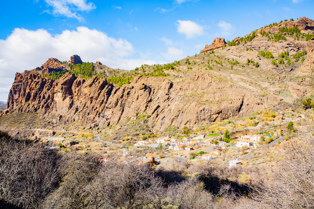
The small village of Ayacata is part of the municipality of San Bartolomé de Tirajana and is situated in one of the most spectacular landscapes of central Gran Canaria. It’s located at more than 1,300 metres above sea level and has less than 40 inhabitants.
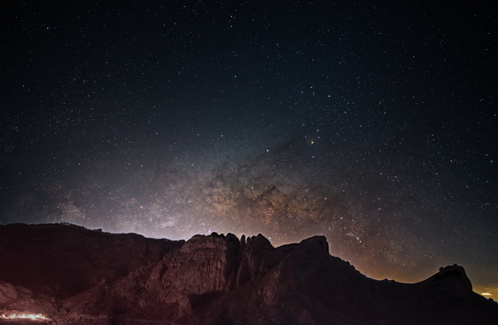
Situated at the base of the south face of the basaltic formation of the natural symbol of Gran Canaria, Roque Nublo, it offers spectacular views of the island's peaks and cliffs. Ayacata is one of the best places to practice classic climbing and has numerous walls with more than 100 routes suitable for climbing different pitches.
It consists of the small village below the cliff and the ravine. Ayacata, located between the ancient phonolitic lava flows of the Roque Nublo eruption, bears witness to the most important volcanic eruption in the history of Gran Canaria, which occurred more than three million years ago.
Discover the varied volcanic landscapes of the island and enjoy the views from the peaks of Gran Canaria, such as the longest ravine on the island, Arguineguín, or the largest dam on the island, Soria.
Etymology of Ayacata
The name "Aquerata", which appears in the famous "Acta de Zumeta" around 1400, probably refers to Ayacata. But it’s certain that the name, with some other variants such as "Aycata", begins to appear with some frequency in the documents of the Repartimientos of Gran Canaria from 1543 onwards. On the other hand, "aya-" may be a prefix of other Guanche names, meaning "depression", while "aga-" means "elevation". However, the origin of 'Ayacata' cannot be determined exactly.
Climbing on the island's peaks
Ayacata has routes of varying degrees of difficulty. If you’re looking for an adventure, here you’ll find some of the most challenging routes on Gran Canaria. For those who want to climb Roque Nublo, there are also several routes of all levels of difficulty.
The walls of La Librería and El Frontón
Near Ayacata you’ll find the El Frontón wall which, together with La Librería, is one of the most popular and frequented walls. Both are crossed by numerous routes, some of which are very emblematic and reach a height of 150 metres. Other well-known and higher walls are the cliff of El Laurel and the wall of El Pino, which reach 200 metres.
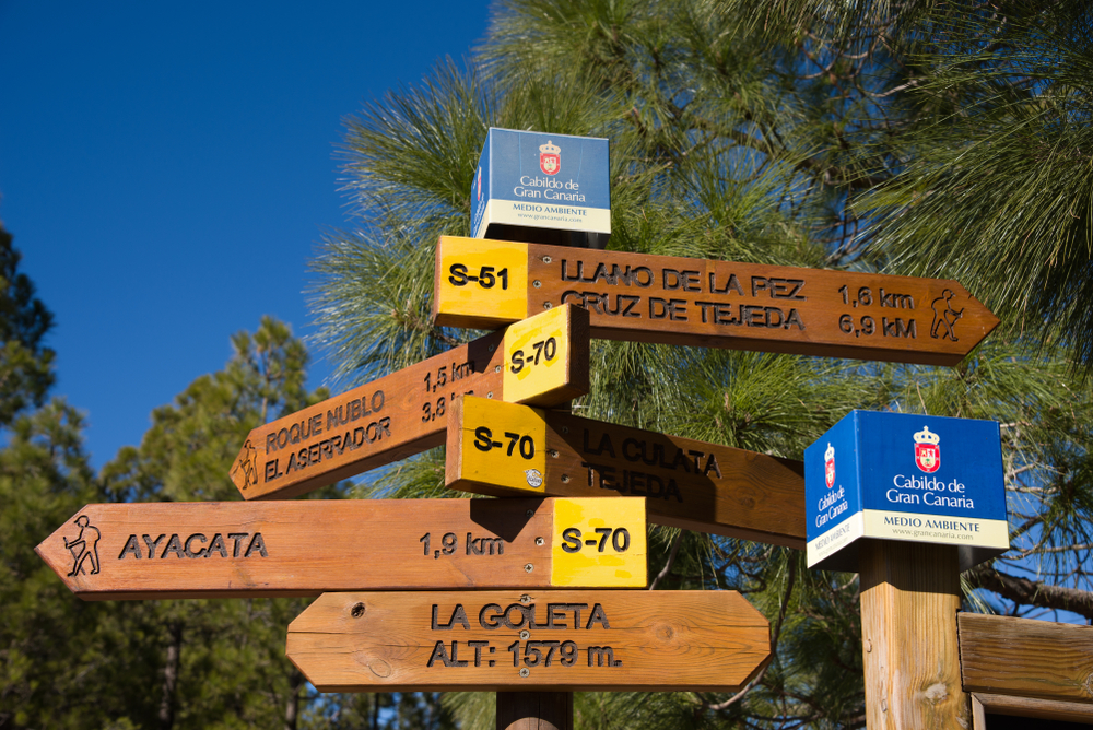
The Ayacata circular path
If you like hiking, this 10-kilometre route may be of interest to you.
Distance
10 km
Difficulty
Easy
Minimum altitude
1250 m
Maximum altitude
1630 m
Difference in altitude
640 m
This trail starts from the village of Ayacata and leads through important places such as Piedra del Almogarén, Degollada de la Goleta, Culata de Tejeda, Barranquillo del Agua, Cruz de Juan Pérez, Esquina del Morro, Casa del Pino, Lomo de la Mancha Verde, Cañada de los Gaspares and Degollada Blanca, among others. Follow the route here → Ruta Circular Ayacata.
Accommodation in Gran Canaria
If you’re looking for accommodation in Gran Canaria where to spend the night or your holiday stay on the island, in VillaGranCanaria we have a wide catalogue of properties for all tastes, from villas, bungalows, apartments to charming country houses in the middle of nature. Choose the type of accommodation that best suits your needs, such as with private pool, in nature, near the beach... Enjoy all the exclusivity and experience that Gran Canaria has to offer.
array(4) { [0]=> array(31) { ["num"]=> string(3) "428" ["createdDate"]=> string(19) "2022-10-26 12:41:45" ["createdByUserNum"]=> string(3) "440" ["updatedDate"]=> string(19) "2022-10-26 13:21:46" ["updatedByUserNum"]=> string(3) "440" ["dragSortOrder"]=> string(3) "106" ["enlace"]=> string(28) "/experiences/roque-bentayga/" ["title"]=> string(48) "Roque Bentayga: the small brother of Roque Nublo" ["content"]=> string(11468) "<p><span style="background-color:transparent;">Roque Bentayga is one of the <strong>unique geological formations</strong> of Gran Canaria and, together with the caves <strong>Cuevas del Rey</strong> and the <strong>Roque Camello necropolis</strong>, forms part of the <strong>three archaeological sites in the area</strong>. It’s located inside the volcanic caldera of <strong>Tejeda</strong>, in the heart of the island. Bentayga is within the Network of <strong>Protected Natural Spaces</strong>.</span><br> </p><p><span style="background-color:transparent;">Roque Bentayga is considered an archaeological monument because it has an <i>almogarén </i>on its east face, that is, a sacred place where the aborigines carried out their ritual and religious practices. It’s also an interesting place for children.</span></p><p> </p><p><span style="background-color:transparent;">The landscape that surrounds Roque Bentayga was defined as a "petrified tempest" by Miguel de Unamuno. If you're in Gran Canaria, and you're thinking of a trip to Tejeda, don't miss Roque Bentayga!</span><br> </p><h2 class="text-3xl m-0 mb-3"><span style="background-color:transparent;">Route to Roque Bentayga</span></h2><p><span style="background-color:transparent;">There are several <strong>hiking routes</strong> to the Roque Bentayga. For the <strong>shortest route</strong>, which leaves from the <strong>interpretation centre</strong>, you can leave your car in a car park at the foot of the Roque. The trail is well-marked out, so it’s not very difficult and is also <strong>accessible for children</strong>. It’s <strong>less than 2 kilometres long</strong> and can be reached in <strong>less than an hour</strong>. However, the path is quite steep. In less than half an hour you’ll reach one of the caves, and you can discover more about how the aborigines buried their dead or how they kept their food.</span><br> </p><h2 class="text-3xl m-0 mb-3"><span style="background-color:transparent;">Characteristics</span></h2><p><span style="background-color:transparent;">Roque Bentayga is one of the <strong>most symbolic natural monuments</strong> on the island. As for its characteristics, it has <strong>basaltic pitons</strong> typical of the island's geological structure. Its height reaches more than 1,400 metres above sea level. On the other hand, Bentayga is located within the <strong>Nublo Rural Park</strong>. In fact, the two Roques are often confused because of their similar appearance.</span></p><p> </p><h2 class="text-3xl m-0 mb-3"><span style="background-color:transparent;">History of Roque Bentayga</span></h2><p><span style="background-color:transparent;">The Roque served as a <strong>fortress</strong> for the aboriginal Canary Islanders until the end of the 15th century with the arrival of the Castilian troops. Nowadays, it serves as an <strong>equinoctial marker</strong> and is of great astronomical value.</span></p><p> </p><h2 class="text-3xl m-0 mb-3"><span style="background-color:transparent;">What to see in Roque Bentayga</span></h2><figure class="image w-full max-w-full flex flex-wrap justify-center mx-auto"><img class="w-full" src="https://villagrancanaria.com/cms/uploads/shutterstock_415398127_1.jpg" alt="roque bentayga with the caldera de tejeda at the background"></figure><p><span style="background-color:transparent;">Roque Bentayga offers a unique spectacle from a scenic point of view, among them:</span><br> </p><ul style="list-style-type:disc;"><li class="relative ml-5"><span style="background-color:transparent;"><strong>Caves</strong>: we highlight the caves of <strong>El Rey</strong> and <strong>Roque Camello</strong>, which are an ancient <strong>aboriginal Canarian settlement</strong> with <strong>more than a hundred caves</strong> with rooms etc.</span></li><li class="relative ml-5"><span style="background-color:transparent;">Cave paintings, inscriptions, walls... such as the <i>almogarén</i> of Bentayga, located on the eastern side of the base. Other sources indicate that it was used as a defensive bastion. In addition, rock engravings have been found in the Libyco-Berber alphabet.</span></li><li class="relative ml-5"><span style="background-color:transparent;">The <strong>Tejeda Ravine</strong> (or <i><strong>Barranco Grande</strong></i>).</span></li></ul><p> </p><h3 class="text-2xl m-0 mb-3"><span style="background-color:transparent;">The Sacred Mountains of Gran Canaria</span></h3><p><span style="background-color:transparent;">The Montañas Sagradas of Gran Canaria have been a <strong>UNESCO World Heritage Site</strong> since <strong>2019</strong>. From the top of Roque Bentayga you’ll have spectacular views.</span></p><p> </p><h3 class="text-2xl m-0 mb-3"><span style="background-color:transparent;">Interpretation Centre and Viewpoint</span></h3><p><span style="background-color:transparent;">Next to the car park is the Roque Bentayga <strong>Interpretation Centre</strong> and <strong>Viewpoint,</strong> where you can learn all the archaeological details of the Sierra de Bentayga. <strong>Entry is free</strong>. Here you’ll find several rooms with panels and interactive screens. <strong>Open from Monday to Sunday</strong>. We also recommend the free half-hour guided tour of the Roque offered by the Centre.</span></p><p> </p><h3 class="text-2xl m-0 mb-3"><span style="background-color:transparent;">Tejeda</span></h3><figure class="image w-full max-w-full flex flex-wrap justify-center mx-auto"><img class="w-full" src="https://villagrancanaria.com/cms/uploads/shutterstock_601291901_1.jpg" alt="village of tejeda with its white houses"></figure><p><span style="background-color:transparent;">Tejeda is considered one of the <strong>most beautiful villages in Spain</strong> - discover it here! → </span><a href="https://villagrancanaria.com/experiences/tejeda-gran-canaria/"><span style="background-color:transparent;"><strong><u>Tejeda</u></strong></span></a></p><p><span style="background-color:transparent;">We also recommend some of <strong>Tejeda's hiking trails</strong> that pass through the <strong>Charco de la Paloma</strong> (where, with luck, you can see a <strong>natural </strong></span><a href="https://villagrancanaria.com/blog/gran-canaria-waterfalls/"><span style="background-color:transparent;"><strong><u>waterfall</u></strong></span></a><span style="background-color:transparent;">), the Cruz de Timagada and the Culata de Tejeda. They offer spectacular views of Roque Bentayga from afar.</span></p><p> </p><h3 class="text-2xl m-0 mb-3"><span style="background-color:transparent;">Roque Nublo Natural Monument</span></h3><figure class="image w-full max-w-full flex flex-wrap justify-center mx-auto"><img class="w-full" src="https://villagrancanaria.com/cms/uploads/shutterstock_1601326954_4.jpg" alt="roque nublo with the caldera de tejeda at the background"></figure><p><a href="https://villagrancanaria.com/en/experiences/roque-nublo/"><span style="background-color:transparent;"><strong><u>Roque Nublo</u></strong></span></a><span style="background-color:transparent;"> is often confused with Roque Bentayga. Roque Nublo is the <strong>highest rock on the island</strong> and is one of the largest natural rocks in the world.</span></p><p> </p><h3 class="text-2xl m-0 mb-3"><span style="background-color:transparent;">The big basket</span></h3><figure class="image w-full max-w-full flex flex-wrap justify-center mx-auto"><img class="w-full" src="https://villagrancanaria.com/cms/uploads/shutterstock_2200916003_1.jpg" alt="the big basket of roque bentayga"></figure><p><span style="background-color:transparent;">On the way to Roque Bentayga, passing Tejeda, you’ll see a huge basket (<i>Gran Cesta</i>). The basket is a spectacular photo opportunity where you can frame the Roque Bentayga in the background. Don't miss this souvenir of your trip!</span></p><p> </p><h2 class="text-3xl m-0 mb-3" style="text-align:center;"><span style="background-color:transparent;">FAQ</span></h2><h3 class="text-2xl m-0 mb-3"><span style="background-color:transparent;">How long does it take to climb Roque Bentayga?</span></h3><p><span style="background-color:transparent;">It takes <strong>less than an hour</strong> to climb Roque Bentayga.</span><br> </p><h3 class="text-2xl m-0 mb-3"><span style="background-color:transparent;">What does Bentayga mean?</span></h3><p><span style="background-color:transparent;">There are different theories about the <strong>meaning</strong> of Bentayga, as the information gathered during the conquest is contradictory, as well as irregularities in the way the Roque was written and referred to.</span><br> </p><ul style="list-style-type:disc;"><li class="relative ml-5"><span style="background-color:transparent;">The most popular interpretation is that "ben-" means "place of", thus meaning "place that supports". This theory is in line with the religious and cosmological ideas of the Guanches, who considered the place an <i>axis mundi</i>.</span></li><li class="relative ml-5"><span style="background-color:transparent;">The second interpretation is that it’s a compound of the Numidian word "bent-", meaning "mountain", and the Mycenaean word "aiga", meaning "sacred".</span></li><li class="relative ml-5"><span style="background-color:transparent;">The third interpretation suggests that the prefix "ben-" has a meaning of belonging, while "(t)aiga" may refer to the Tenerife word Tigaiga or the Lanzarote word Taiga. It would mean, then, "the one from taiga".</span></li></ul><p> </p><h3 class="text-2xl m-0 mb-3"><span style="background-color:transparent;">How to get to Roque Bentayga?</span></h3><p><span style="background-color:transparent;">You can get to Roque Bentayga via the GC-607 road and, at kilometre 10, turn off towards El Espinillo. Follow the road for half a kilometre, and you’ll come to the car park.</span></p><p> </p><h3 class="text-2xl m-0 mb-3"><span style="background-color:transparent;">When to visit Roque Bentayga?</span></h3><p><span style="background-color:transparent;">The best time to visit Roque Bentayga is between <strong>January and February</strong>, as it coincides with the <strong>almond blossom</strong>.</span></p><p> </p><h3 class="text-2xl m-0 mb-3"><span style="background-color:transparent;">Accommodation</span></h3><p><span style="background-color:transparent;">If you want to stay near Roque Bentayga or other important monuments in Gran Canaria, we offer you a wide range of holiday rentals: </span><a href="https://villagrancanaria.com/country-houses/"><span style="background-color:transparent;"><u>country houses</u></span></a><span style="background-color:transparent;"> in the middle of nature, majestic villas with </span><a href="https://villagrancanaria.com/private-pool/"><span style="background-color:transparent;"><u>private pools</u></span></a><span style="background-color:transparent;">, </span><a href="https://villagrancanaria.com/city-apartment/"><span style="background-color:transparent;"><u>apartments in the city</u></span></a><span style="background-color:transparent;"> and much more. Don't miss out!</span></p>" ["titulo_de_pagina"]=> string(49) "Roque Bentayga in Gran Canaria | VillaGranCanaria" ["metatag_descripcion"]=> string(131) "Discover the rock formation Roque Bentayga on Gran Canaria: hiking route, viewpoint, history, characteristics, what to see and FAQ." ["experience_type"]=> string(1) "8" ["short_description"]=> string(75) "Roque Bentayga is the small brother of Roque Nublo. Discover all around it!" ["city"]=> string(3) "100" ["related_experiences"]=> string(29) " 397 366 360 359 345 339 324 " ["visible"]=> string(1) "1" ["draft"]=> string(1) "0" ["admin_only_section"]=> string(1) "0" ["autosaved"]=> string(1) "0" ["builder"]=> string(0) "" ["controlador"]=> string(0) "" ["precontrolador"]=> string(0) "" ["tableName"]=> string(11) "experiences" ["image"]=> array(1) { [0]=> array(12) { ["num"]=> string(6) "473028" ["tableName"]=> string(11) "experiences" ["fieldName"]=> string(5) "image" ["recordNum"]=> string(3) "428" ["filePath"]=> string(84) "/var/www/vhosts/villagrancanaria.com/httpdocs/cms/uploads/shutterstock_415398127.jpg" ["urlPath"]=> string(39) "/cms/uploads/shutterstock_415398127.jpg" ["info1"]=> string(0) "" ["info2"]=> string(0) "" ["info3"]=> string(0) "" ["info4"]=> string(0) "" ["info5"]=> string(0) "" ["alt"]=> string(48) "roque bentayga con la caldera de tejeda de fondo" } } ["main_image"]=> array(0) { } ["gallery"]=> array(0) { } ["experience_type_bd"]=> array(1) { [0]=> array(17) { ["num"]=> string(1) "8" ["createdDate"]=> string(19) "2020-01-30 15:23:50" ["createdByUserNum"]=> string(3) "102" ["updatedDate"]=> string(19) "2022-03-29 09:42:16" ["updatedByUserNum"]=> string(3) "514" ["dragSortOrder"]=> string(1) "9" ["enlace"]=> string(24) "/experiences/excursions/" ["name"]=> string(10) "Excursions" ["titulo_de_pagina"]=> string(31) "Excursions - Villa Gran Canaria" ["metatag_descripcion"]=> string(142) "Discover everything about excursions in the Canary Islands thanks to Villa Gran Canaria, the leading holiday rental portal in the archipelago." ["visible"]=> string(1) "1" ["tableName"]=> string(16) "experience_types" ["image"]=> array(1) { [0]=> array(12) { ["num"]=> string(3) "973" ["tableName"]=> string(16) "experience_types" ["fieldName"]=> string(5) "image" ["recordNum"]=> string(1) "8" ["filePath"]=> string(84) "/var/www/vhosts/villagrancanaria.plandeweb.com/httpdocs/cms/uploads/experience_8.png" ["urlPath"]=> string(29) "/cms/uploads/experience_8.png" ["info1"]=> string(11) "Excursiones" ["info2"]=> string(0) "" ["info3"]=> string(0) "" ["info4"]=> string(0) "" ["info5"]=> string(0) "" ["alt"]=> string(0) "" } } ["icon"]=> array(1) { [0]=> array(12) { ["num"]=> string(4) "1054" ["tableName"]=> string(16) "experience_types" ["fieldName"]=> string(4) "icon" ["recordNum"]=> string(1) "8" ["filePath"]=> string(75) "/var/www/vhosts/villagrancanaria.plandeweb.com/httpdocs/cms/uploads/map.png" ["urlPath"]=> string(20) "/cms/uploads/map.png" ["info1"]=> string(0) "" ["info2"]=> string(0) "" ["info3"]=> string(0) "" ["info4"]=> string(0) "" ["info5"]=> string(0) "" ["alt"]=> string(0) "" } } ["banner_images"]=> array(1) { [0]=> array(12) { ["num"]=> string(4) "1090" ["tableName"]=> string(16) "experience_types" ["fieldName"]=> string(13) "banner_images" ["recordNum"]=> string(1) "8" ["filePath"]=> string(107) "/var/www/vhosts/villagrancanaria.plandeweb.com/httpdocs/cms/uploads/dino_reichmuth_A5rCN8626Ck_unsplash.jpg" ["urlPath"]=> string(52) "/cms/uploads/dino_reichmuth_A5rCN8626Ck_unsplash.jpg" ["info1"]=> string(0) "" ["info2"]=> string(0) "" ["info3"]=> string(0) "" ["info4"]=> string(0) "" ["info5"]=> string(0) "" ["alt"]=> string(0) "" } } ["breadcrumbField"]=> string(0) "" ["mainFieldBreadcrumb"]=> string(10) "Excursions" } } ["city_bd"]=> array(1) { [0]=> array(38) { ["num"]=> string(1) "1" ["createdDate"]=> string(19) "2020-09-10 16:08:18" ["createdByUserNum"]=> string(1) "1" ["updatedDate"]=> string(19) "2023-12-22 16:11:47" ["updatedByUserNum"]=> string(1) "1" ["dragSortOrder"]=> string(10) "1703261507" ["name"]=> string(12) "Gran Canaria" ["booki_id"]=> string(3) "100" ["booki_name"]=> string(12) "GRAN CANARIA" ["booki_active"]=> string(1) "1" ["enlace"]=> string(14) "/gran-canaria/" ["description"]=> string(249) "Gran Canaria is a miniature continent where you'll find lots of special things to do. Sail out to watch whales, walk in the Canary pine forests, have fun at a water park, wander its shopping streets, visit museums or just relax on a beautiful beach." ["visible"]=> string(1) "1" ["visible_experiencias"]=> string(1) "1" ["booki_exists"]=> string(1) "1" ["titulo_de_pagina"]=> string(50) "Holiday Rentals in Gran Canaria | VillaGranCanaria" ["metatag_descripcion"]=> string(132) "Find and book Holiday Rentals in Gran Canaria at the best price. Apartments, houses, villas, bungalows... Enjoy a unique experience." ["h1"]=> string(36) "Book Holiday Rentals in Gran Canaria" ["content"]=> string(21014) "<h2 class="text-3xl m-0 mb-3">Gran Canaria Holiday Rentals</h2><p>Gran Canaria offers a wide range of activities and attractions for visitors to enjoy. One of the main draws of the island is its <strong>stunning beaches</strong>. From the bustling Playa del Inglés to the more secluded Maspalomas, there are plenty of options to relax, sunbathe, and swim in the crystal-clear waters of the Atlantic Ocean. Water sports enthusiasts can also indulge in activities like surfing, windsurfing, and diving in popular spots such as Las Canteras and Puerto de Mogán.</p><p> </p><p>Aside from its beautiful coastline, Gran Canaria is renowned for its diverse landscapes. The island is home to stunning natural wonders like the dramatic cliffs of Puerto de Mogán, the rugged mountains of Roque Nublo, and the lush forests of Doramas Rural Park. Hiking and biking trails are abundant, allowing visitors to explore the island's unique flora and fauna.</p><p> </p><p><strong>Culture and history</strong> enthusiasts will be fascinated by Gran Canaria's rich heritage. The capital city of Las Palmas de Gran Canaria boasts historical sites like the grand <strong>Cathedral of Santa Ana</strong> and the <i><strong>Casa de Colón</strong></i>, a museum dedicated to Christopher Columbus. The picturesque towns of Teror and Arucas are also worth a visit, with their charming colonial architecture and scenic plazas.</p><p> </p><p>For those seeking <strong>entertainment and nightlife</strong>, Gran Canaria doesn't disappoint. The island is famous for its vibrant nightlife scene, particularly in popular areas like Playa del Inglés and Puerto Rico. Visitors can enjoy a variety of bars, clubs, and live music venues, ensuring there is always something happening after the sun goes down.</p><p> </p><p>In summary, Gran Canaria offers a diverse range of activities and sights to satisfy all types of travelers. From its stunning beaches to its picturesque landscapes and rich cultural heritage, there is something for everyone to enjoy on this beautiful island.</p><p> </p><h2 class="text-3xl m-0 mb-3">The weather in Gran Canaria</h2><p style="text-align:justify;">Did you know that the days in Gran Canaria are long and sunny with mild temperatures and few variations? In fact, Gran Canaria is one of the regions in Europe with <strong>more hours of sunlight</strong> – over 3,000.</p><p style="text-align:justify;"> </p><p style="text-align:justify;">Its geographical location also favours long days that are full of sunlight all year round. In winter, the sun rises at 7:30am and sets at 6:30pm; in summer it’s sunrise at 7:00am and sunset at 8:30pm.</p><p style="text-align:justify;"> </p><h2 class="text-3xl m-0 mb-3">Accommodation options in Gran Canaria</h2><p style="text-align:justify;">Have you already decided that you want to spend your next holiday on the beautiful island of Gran Canaria and you need a holiday rental? Gran Canaria is an island with a huge offer of accommodation of all kinds and for all tastes.</p><p style="text-align:justify;"> </p><h3 class="text-2xl m-0 mb-3">Villas</h3><p style="text-align:justify;">A villa is probably the best option for those looking for maximum privacy. At VillaGranCanaria we are experts in renting villas of all types:</p><p style="text-align:justify;"> </p><ul class='bullet'><li class="relative ml-5 list-disc" style="text-align:justify;"><strong>Villas with private pool:</strong> the best option to enjoy a good bath without sharing space with other people.</li><li class="relative ml-5 list-disc" style="text-align:justify;"><strong>Luxury villas:</strong> if you are looking to treat yourself, the best is a deluxe villa with all kinds of comforts and magnificent views.</li><li class="relative ml-5 list-disc" style="text-align:justify;"><strong>Beach villas:</strong> look no further if you want to wake up to the gentle sea breeze or be mesmerised by the coastal sunsets.</li><li class="relative ml-5 list-disc" style="text-align:justify;"><strong>Cheap villas:</strong> the best high quality accommodation at an affordable price and with the greatest possible comfort.</li><li class="relative ml-5 list-disc" style="text-align:justify;"><strong>Group villas:</strong> the ultimate choice for families with children or groups of friends looking for peace and quiet and a higher degree of privacy.</li></ul><p style="text-align:justify;"> </p><h3 class="text-2xl m-0 mb-3">Apartments</h3><p style="text-align:justify;">Those who prefer to stay in a holiday flat are generally looking to spend more time outside than inside. Even so, at VillaGranCanaria we have great alternatives:</p><p style="text-align:justify;"> </p><ul class='bullet'><li class="relative ml-5 list-disc" style="text-align:justify;"><strong>Beach apartments:</strong> a flat just a few metres from the sea is the best choice for ocean addicts.</li><li class="relative ml-5 list-disc" style="text-align:justify;"><strong>City apartments:</strong> urbanites are in luck because an urban flat is the best way to discover the city's corners.</li><li class="relative ml-5 list-disc" style="text-align:justify;"><strong>Luxury apartments:</strong> if you prefer to live large, a deluxe flat is the perfect option for you.</li><li class="relative ml-5 list-disc" style="text-align:justify;"><strong>Cheap apartments:</strong> if you prefer a cheap flat with the best value for money on the market... stop looking!</li></ul><p style="text-align:justify;"> </p><h3 class="text-2xl m-0 mb-3">Bungalows</h3><p style="text-align:justify;">One of the most popular options on the market are bungalows. Fortunately, at VillaGranCanaria we have the best bungalows on the island at your disposal:</p><p style="text-align:justify;"> </p><ul class='bullet'><li class="relative ml-5 list-disc" style="text-align:justify;"><strong>Beach bungalows:</strong> Imagine spending a day on the sand and just a few steps from your bungalow... The best possible location!</li><li class="relative ml-5 list-disc" style="text-align:justify;"><strong>Luxury bungalows:</strong> a deluxe bungalow is a great option to enjoy the highest comfort in a unique accommodation.</li><li class="relative ml-5 list-disc" style="text-align:justify;"><strong>Cheap bungalows:</strong> the budget bungalows are ideal for sharing, always keeping in mind the best value for money.</li><li class="relative ml-5 list-disc" style="text-align:justify;"><strong>Bungalows with private pool:</strong> if you prefer not to leave the bungalow and enjoy the pool without "neighbours"... This is your option!</li></ul><p style="text-align:justify;"> </p><h3 class="text-2xl m-0 mb-3">Country houses</h3><p style="text-align:justify;">Nature lovers are in luck because this island has spectacular natural landscapes. Discover them by staying in the rural houses of VillaGranCanaria:</p><p style="text-align:justify;"> </p><ul class='bullet'><li class="relative ml-5 list-disc" style="text-align:justify;"><strong>Luxury country houses:</strong> the ideal option to enjoy nature to the maximum with the best comforts in a unique accommodation with incredible views.</li><li class="relative ml-5 list-disc" style="text-align:justify;"><strong>Family country houses:</strong> the alternative for families who want to enjoy the interior of Gran Canaria doing activities with their children.</li></ul><p style="text-align:justify;"> </p><h2 class="text-3xl m-0 mb-3">Travel information for your holiday rentals on Gran Canaria</h2><p style="text-align:justify;">If you're thinking of a holiday rental in Gran Canaria, mark your calendar because this beautiful island is more than just sun, beach and spectacular scenery. Not for nothing is it known as the miniature continent.</p><p style="text-align:justify;"> </p><h3 class="text-2xl m-0 mb-3">Southern Gran Canaria: idyllic beaches surrounded by tradition</h3><p style="text-align:justify;">Being one of the most important tourist destinations in Spain, it is not surprising that most of the tourists who decide to book their holidays in Gran Canaria do so attracted by its dream beaches. And the closest places to enjoy the island's coastline to the full are Salobre Golf, Maspalomas, Meloneras or Pasito Blanco, among others.</p><p style="text-align:justify;"> </p><h3 class="text-2xl m-0 mb-3">Northern Gran Canaria: extraordinary landscapes of cliffs and volcanoes</h3><p style="text-align:justify;">However, more and more people are visiting this destination for rural tourism, hiking, water sports or cycling, and to discover fascinating places such as Roque Nublo, Roque Bentayga or Pico de las Nieves. Be sure to discover charming villages such as Tejeda, San Mateo, Teror, Arucas, Gáldar and Agaete, among others.</p><p style="text-align:justify;"> </p><h3 class="text-2xl m-0 mb-3">Las Palmas de Gran Canaria: the best cultural, commercial and leisure offer on the island</h3><p style="text-align:justify;">The island's capital, a cosmopolitan city open to the sea, is Gran Canaria's main cultural, commercial and leisure attraction. Here you will find everything: shopping centres, museums, restaurants, the kilometre-long and impressive Las Canteras beach, the majestic Alfredo Kraus Auditorium, the historic Cathedral of Santa Ana... the list goes on and on!</p><p style="text-align:justify;"> </p><h2 class="text-3xl m-0 mb-3">How to get to your holiday rental in Gran Canaria</h2><p style="text-align:justify;">The best way to travel to Gran Canaria is by air to the Gran Canaria Airport (LPA), which is located around the middle of the east coast of the island. It is situated more or less at the same distance (about 25 kilometres) from the capital, Las Palmas de Gran Canaria, and the southern part, a true sunny paradise.</p><p style="text-align:justify;"> </p><p style="text-align:justify;">No matter the location of your Gran Canaria holiday home, it will likely be accessible by transportation from the airport. Buses, coaches and taxis are all available for you to bring you to your destination. Rental cars are also available at the airport, which ensure a quicker and more comfortable journey.</p><p style="text-align:justify;"> </p><h2 class="text-3xl m-0 mb-3">Gran Canaria and its gastronomy</h2><p style="text-align:justify;">The local cuisine of the Canary Islands comprises a variety of fresh vegetables and a mix of seafood and meat. This gastronomy is influenced by many cultures, most prevalently Spanish, North African, Latin American and even historical aboriginal themes also influence the vibrant local dishes.</p><p style="text-align:justify;"> </p><p style="text-align:justify;">We encourage you to choose from the large variety of traditional restaurants called bochinches or guachinches throughout the island if a true Canarian culinary experience is what you are after. Nevertheless, there are plenty of restaurants where international gastronomy can be found.</p><p style="text-align:justify;"> </p><h2 class="text-3xl m-0 mb-3">What to do in Gran Canaria with children</h2><p style="text-align:justify;">For a different and fun family holiday, there is nothing better than a visit to Gran Canaria. The island has everything the little ones need to have a great time: water parks, theme parks, amusement parks, outdoor activities, zoos, aquariums and the chance to live unforgettable experiences and adventures in places where fun for young and old is always guaranteed.</p><p style="text-align:justify;"> </p><h3 class="text-2xl m-0 mb-3">Water parks</h3><p style="text-align:justify;">Although all the water parks are ideal for having a great time, spending a day at Aqualand Maspalomas or Lago Taurito (100% salt water) is an unforgettable experience not to be missed if you are travelling to Gran Canaria with children.</p><p style="text-align:justify;"> </p><h3 class="text-2xl m-0 mb-3">Theme parks</h3><p style="text-align:justify;">Children always have a great time at theme parks. It's a safe bet. And in Gran Canaria there are two of the best: Sioux City Park (where they will feel like a western sheriff) and GrancAventura (a different adventure park...).</p><p style="text-align:justify;"> </p><h3 class="text-2xl m-0 mb-3">Amusement parks</h3><p style="text-align:justify;">The classic amusement parks are also a great attraction for children. Here you will find two spectacular ones: Angry Birds Activity Park (for action-packed fun) and Holidayworld Maspalomas (with countless attractions, bowling, escape room, karaoke...).</p><p style="text-align:justify;"> </p><h3 class="text-2xl m-0 mb-3">Zoos and aquariums</h3><p style="text-align:justify;">Gran Canaria also has zoos and aquariums where you can discover all kinds of exotic animals up close: Palmitos Park (with a large number of birds, plants, reptiles, mammals...) and Poema del Mar (with three well-differentiated areas and thousands of marine species).</p><p style="text-align:justify;"> </p><h2 class="text-3xl m-0 mb-3">Practising sports in Gran Canaria</h2><p style="text-align:justify;">Gran Canaria is famous for its magnificent beaches of fine sand and crystal-clear waters, but also offers much more than sun and sand. Its lush forests, mountains, trails, ravines, beaches, reefs and clean skies are some of the natural spaces in Gran Canaria that invite you to do active tourism, without forgetting relaxation, fun and adventure. Some of the most practiced sports on the island are:</p><p style="text-align:justify;"> </p><h3 class="text-2xl m-0 mb-3">Golf</h3><p style="text-align:justify;">Gran Canaria provides fully equipped infrastructures and top-class courses adapted for all handicaps designed by world champions and reputed architects like Salobre Golf. The climate here means you can enjoy golf all year round to focus on your game and disconnect from it all. And after a few swings, there’s practically no better plan than to spend a while relaxing on the beach, for professionals and amateurs alike.</p><p style="text-align:justify;"> </p><h3 class="text-2xl m-0 mb-3">Cycling</h3><p style="text-align:justify;">Gran Canaria has a huge variety of ideal routes for road cycling, with paved tracks and roads with slopes and gradients that cross volcanic passes posing a great challenge for cyclists of all levels. The unchanging temperatures throughout the year and the low rainfall enable you to go cycling every day of the year.</p><p style="text-align:justify;"> </p><h3 class="text-2xl m-0 mb-3">Water sports</h3><p style="text-align:justify;">The sea around the island allows for many water sports to be practiced, like the following ones:</p><p style="text-align:justify;"> </p><ul class='bullet'><li class="relative ml-5 list-disc" style="text-align:justify;">Surfing</li><li class="relative ml-5 list-disc" style="text-align:justify;">Windsurfing</li><li class="relative ml-5 list-disc" style="text-align:justify;">Kitesurfing</li><li class="relative ml-5 list-disc" style="text-align:justify;">Bodyboarding</li><li class="relative ml-5 list-disc" style="text-align:justify;">Stand up paddle</li><li class="relative ml-5 list-disc" style="text-align:justify;">Scuba diving</li><li class="relative ml-5 list-disc" style="text-align:justify;">Snorkeling</li><li class="relative ml-5 list-disc" style="text-align:justify;">Sailing</li><li class="relative ml-5 list-disc" style="text-align:justify;">Parasailing</li><li class="relative ml-5 list-disc" style="text-align:justify;">Kayaking</li><li class="relative ml-5 list-disc" style="text-align:justify;">Fishing</li><li class="relative ml-5 list-disc" style="text-align:justify;">Jet skiing</li></ul><p style="text-align:justify;"> </p><h3 class="text-2xl m-0 mb-3">Mountain sports</h3><p style="text-align:justify;">Of course, apart from sea sports there are lots of mountain sports you can do on the island:</p><p style="text-align:justify;"> </p><ul class='bullet'><li class="relative ml-5 list-disc" style="text-align:justify;">Hiking</li><li class="relative ml-5 list-disc" style="text-align:justify;">Trail running</li><li class="relative ml-5 list-disc" style="text-align:justify;">Climbing</li><li class="relative ml-5 list-disc" style="text-align:justify;">Mountain biking</li><li class="relative ml-5 list-disc" style="text-align:justify;">Trekking</li><li class="relative ml-5 list-disc" style="text-align:justify;">Orienteering</li><li class="relative ml-5 list-disc" style="text-align:justify;">Canyoning</li><li class="relative ml-5 list-disc" style="text-align:justify;">Paragliding</li></ul><p style="text-align:justify;"> </p><h2 class="text-3xl m-0 mb-3">Museums in Gran Canaria</h2><p style="text-align:justify;">Theatre, dance, concerts and plastic arts go hand in hand in the island's cultural agenda.</p><p style="text-align:justify;"> </p><h3 class="text-2xl m-0 mb-3">1. Museo Néstor</h3><p style="text-align:justify;">In the Museo Néstor, named after the local artist Néstor de la Torre, you can see his portraits and most important works. It is located in the Pueblo Canario, in the capital of Gran Canaria.</p><p style="text-align:justify;"> </p><h3 class="text-2xl m-0 mb-3">2. Casa de Colón</h3><p style="text-align:justify;">The Casa de Colón, located in the Vegueta district of the historic quarter of Las Palmas de Gran Canaria, is the best option for discovering the island's relationship with the American continent and what oceanic voyages were like.</p><p style="text-align:justify;"> </p><h3 class="text-2xl m-0 mb-3">3. CAAM</h3><p style="text-align:justify;">Nearby, the Centro Atlántico de Arte Moderno (CAAM or Atlantic Centre of Modern Art) is the archipelago's leading contemporary art museum. Highly recommended for those looking for a different kind of museum.</p><p style="text-align:justify;"> </p><h3 class="text-2xl m-0 mb-3">4. Museo Canario</h3><p style="text-align:justify;">What were the ancient Canarians like and how did they live? The answer to these and many more questions can be found at the Museo Canario in Las Palmas. Its large collection of aboriginal mummies will leave you speechless.</p><p style="text-align:justify;"> </p><h3 class="text-2xl m-0 mb-3">5. Museo Elder</h3><p style="text-align:justify;">The Elder Museum of Science and Technology has one rule that everyone who enters the museum must obey: it is strictly forbidden not to touch. Young and old alike will have a great time in a 100% interactive museum.</p><p style="text-align:justify;"> </p><h2 class="text-3xl m-0 mb-3">Nightlife in Gran Canaria</h2><p style="text-align:justify;">If nightlife is your thing, Gran Canaria is the place to go, with a vibrant and fun atmosphere throughout the cities on the island. Choose from a range of pubs, bars, clubs and discos, in cities like Las Palmas, Playa del Inglés, Maspalomas and Meloneras.</p><p style="text-align:justify;"> </p><p style="text-align:justify;">In fact, in certain areas the island seems to never sleep, and parties deep into the night. If you are looking for a quieter atmosphere, skip the clubs and check out the numerous stylish bars, cafés and casinos throughout the cities on the island.</p><p style="text-align:justify;"> </p><h2 class="text-3xl m-0 mb-3">What to see in Gran Canaria</h2><p style="text-align:justify;">On an island that offers as much to the visitor as Gran Canaria, you should not miss the most attractive places on the island:</p><p style="text-align:justify;"> </p><h3 class="text-2xl m-0 mb-3">1. Maspalomas Dunes</h3><p style="text-align:justify;">Located on the south coast of the island, the dunes of Maspalomas were formed from ocean sand during the Ice Age and are now a nature reserve.</p><p style="text-align:justify;"> </p><h3 class="text-2xl m-0 mb-3">2. Roque Nublo</h3><p style="text-align:justify;">The Roque Nublo, located in Tejeda and 67 metres high, was formed by a volcanic eruption millions of years ago and was used by the ancient Canarians for rituals.</p><p style="text-align:justify;"> </p><h3 class="text-2xl m-0 mb-3">3. Las Canteras Beach</h3><p style="text-align:justify;">This urban beach is one of the best in Gran Canaria. It is almost 4 kilometres long and is protected by La Barra, a rock formation with abundant marine life.</p><p style="text-align:justify;"> </p><h3 class="text-2xl m-0 mb-3">4. Vegueta</h3><p style="text-align:justify;">With its narrow cobbled streets, this old part of Las Palmas transports visitors back to the 15th century, with beautiful buildings, galleries and museums steeped in history.</p><p style="text-align:justify;"> </p><h3 class="text-2xl m-0 mb-3">5. Puerto de Mogán</h3><p style="text-align:justify;">The canals that link the marina with the fishing port gave the town its name of Little Venice. It is a place to enjoy fresh fish on a daily basis.</p>" ["experiences_heading"]=> string(31) "Top Experiences in Gran Canaria" ["experiences"]=> string(13) " 362 357 308 " ["faq"]=> string(381) "[{"question":"157"},{"question":"158"},{"question":"159"},{"question":"160"},{"question":"161"},{"question":"162"},{"question":"163"},{"question":"164"},{"question":"165"},{"question":"166"},{"question":"167"},{"question":"168"},{"question":"169"},{"question":"170"},{"question":"171"},{"question":"172"},{"question":"173"},{"question":"174"},{"question":"175"},{"question":"176"}]" ["featured_links_heading"]=> string(0) "" ["faq_heading"]=> string(64) "Frequently asked questions about holiday rentals in Gran Canaria" ["featured_links_heading_2"]=> string(0) "" ["admin_only_section"]=> string(1) "0" ["autosaved"]=> string(1) "0" ["builder"]=> string(0) "" ["controlador"]=> string(0) "" ["precontrolador"]=> string(0) "" ["tableName"]=> string(6) "cities" ["image"]=> array(1) { [0]=> array(12) { ["num"]=> string(4) "1025" ["tableName"]=> string(6) "cities" ["fieldName"]=> string(5) "image" ["recordNum"]=> string(1) "1" ["filePath"]=> string(94) "/var/www/vhosts/villagrancanaria.plandeweb.com/httpdocs/cms/uploads/shutterstock_373706371.jpg" ["urlPath"]=> string(39) "/cms/uploads/shutterstock_373706371.jpg" ["info1"]=> string(0) "" ["info2"]=> string(0) "" ["info3"]=> string(0) "" ["info4"]=> string(0) "" ["info5"]=> string(0) "" ["alt"]=> string(28) "holiday rentals gran canaria" } } ["experience_banner_images"]=> array(2) { [0]=> array(12) { ["num"]=> string(4) "1051" ["tableName"]=> string(6) "cities" ["fieldName"]=> string(24) "experience_banner_images" ["recordNum"]=> string(1) "1" ["filePath"]=> string(105) "/var/www/vhosts/villagrancanaria.plandeweb.com/httpdocs/cms/uploads/tom_keighley_9dnY4x0MKVY_unsplash.jpg" ["urlPath"]=> string(50) "/cms/uploads/tom_keighley_9dnY4x0MKVY_unsplash.jpg" ["info1"]=> string(0) "" ["info2"]=> string(0) "" ["info3"]=> string(0) "" ["info4"]=> string(0) "" ["info5"]=> string(0) "" ["alt"]=> string(31) "gran canaria casas vacacionales" } [1]=> array(12) { ["num"]=> string(5) "20146" ["tableName"]=> string(6) "cities" ["fieldName"]=> string(24) "experience_banner_images" ["recordNum"]=> string(1) "1" ["filePath"]=> string(103) "/var/www/vhosts/villagrancanaria.plandeweb.com/httpdocs/cms/uploads//cms/uploads/2018/03/maspalomas.jpg" ["urlPath"]=> string(35) "/cms/uploads/2018/03/maspalomas.jpg" ["info1"]=> string(0) "" ["info2"]=> string(0) "" ["info3"]=> string(0) "" ["info4"]=> string(0) "" ["info5"]=> string(0) "" ["alt"]=> string(23) "vacaciones gran canaria" } } ["featured_links"]=> array(0) { } ["featured_links_2"]=> array(0) { } ["faq_bd"]=> array(20) { [0]=> array(1) { ["question"]=> string(3) "157" } [1]=> array(1) { ["question"]=> string(3) "158" } [2]=> array(1) { ["question"]=> string(3) "159" } [3]=> array(1) { ["question"]=> string(3) "160" } [4]=> array(1) { ["question"]=> string(3) "161" } [5]=> array(1) { ["question"]=> string(3) "162" } [6]=> array(1) { ["question"]=> string(3) "163" } [7]=> array(1) { ["question"]=> string(3) "164" } [8]=> array(1) { ["question"]=> string(3) "165" } [9]=> array(1) { ["question"]=> string(3) "166" } [10]=> array(1) { ["question"]=> string(3) "167" } [11]=> array(1) { ["question"]=> string(3) "168" } [12]=> array(1) { ["question"]=> string(3) "169" } [13]=> array(1) { ["question"]=> string(3) "170" } [14]=> array(1) { ["question"]=> string(3) "171" } [15]=> array(1) { ["question"]=> string(3) "172" } [16]=> array(1) { ["question"]=> string(3) "173" } [17]=> array(1) { ["question"]=> string(3) "174" } [18]=> array(1) { ["question"]=> string(3) "175" } [19]=> array(1) { ["question"]=> string(3) "176" } } ["breadcrumbField"]=> string(0) "" ["mainFieldBreadcrumb"]=> string(12) "Gran Canaria" } } ["related_experiences_bd"]=> array(7) { [0]=> array(28) { ["num"]=> string(3) "397" ["createdDate"]=> string(19) "2022-02-09 10:25:25" ["createdByUserNum"]=> string(3) "440" ["updatedDate"]=> string(19) "2022-03-30 10:25:03" ["updatedByUserNum"]=> string(3) "514" ["dragSortOrder"]=> string(2) "77" ["enlace"]=> string(46) "/experiences/fortaleza-de-ansite-gran-canaria/" ["title"]=> string(74) "The Fortress of Ansite, the last bastion of the aborigines in Gran Canaria" ["content"]=> string(8982) "<h1 class="text-4xl m-0 mb-3" style="text-align:center;"><span style="background-color:transparent;">The Fortress of Ansite, the last bastion of the aborigines in Gran Canaria</span></h1><p style="text-align:justify;"><span style="background-color:transparent;">In this new VillaGranCanaria article we’ll present to you one of the most significant </span><a href="https://villagrancanaria.com/blog/ancient-history-gran-canaria/"><span style="background-color:transparent;"><u>archaeological sites</u></span></a><span style="background-color:transparent;"> in Gran Canaria, not only on the island, but in the whole of the Canary Islands: the Fortress of Ansite.</span></p><p> </p><p style="text-align:justify;"><span style="background-color:transparent;">Who said that stones don't talk? Anyone who comes here and listens carefully will be able to tell of the infinite number of colours that emerge from the mountains and the skies.</span></p><p> </p><p style="text-align:justify;"><span style="background-color:transparent;">You’ll also discover the reliefs and lose yourself in the nature, you’ll soon feel small in the face of the immensity of which you’re a part.</span><br> </p><h2 class="text-3xl m-0 mb-3" style="text-align:justify;"><span style="background-color:transparent;">What is the Fortress of Ansite on Gran Canaria?</span><br><br><img class="inline-flex align-bottom" src="https://villagrancanaria.com/cms/uploads/Ansite_7_scaled_1.jpg"></h2><p style="text-align:justify;"><span style="background-color:transparent;">It’s the best example of a fortified settlement of the ancient aboriginal society of Gran Canaria, declared an Asset of Cultural Interest and made up of three rocks: La Fortaleza Grande, La Fortaleza Chica and Titana.</span><br> </p><p style="text-align:justify;"><span style="background-color:transparent;">The first inhabitants of the island used it for more than a thousand years as a habitat in caves and houses, as a burial space, a storage place, etc. In fact, the oldest dates of Gran Canaria are found here (4th century).</span><br> </p><p style="text-align:justify;"><span style="background-color:transparent;">Of the Fortaleza Grande, the best-known rock of the site, the thing that stands out the most is the tunnel that crosses the mountain and its summit. The dangerous climb to the top is marked by a series of cave engravings and multiple walls erected to make the ascent easier.</span><br> </p><p style="text-align:justify;"><span style="background-color:transparent;">The remains of two individuals were recovered from the summit in the 19th century, and there were also a series of stone structures. The excavation of these structures yielded many faunal remains. Furthermore, there was observed a high recurrence of fires.</span><br> </p><p style="text-align:justify;"><span style="background-color:transparent;">It’s believed that certain cultural manifestations may have taken place in this area, in particular commensal rituals where the ancestors of the first inhabitants of this area were commemorated.</span><br> </p><p style="text-align:justify;"><span style="background-color:transparent;">Around 1483, only a few fortifications remained on Gran Canaria to protect the island from the European conquerors, one of them being La Fortaleza. It was here that the islanders resisted the siege of Pedro de Vera's troops. </span></p><p> </p><p style="text-align:justify;"><span style="background-color:transparent;">Thus, it’s believed that the Canary Island chief Bentejuí, on 29 April 1483, threw himself from the top of the fortress with the cry of 'Atis Tirma', thus avoiding being taken prisoner by the Castilian troops and playing a leading role in one of the most famous chapters of the conquest of the island.</span></p><p> </p><p style="text-align:justify;"><span style="background-color:transparent;">The archaeological wealth of La Fortaleza (habitat, burial, storage, cultural and cave paintings) led to the area being listed as an Asset of Cultural Interest, the highest level of protection for cultural heritage in the Canary Islands.</span><br> </p><h2 class="text-3xl m-0 mb-3" style="text-align:justify;"><span style="background-color:transparent;">How to get to the Fortress of Ansite</span></h2><p style="text-align:justify;"><span style="background-color:transparent;">The fortress is located in the municipality of Santa Lucía de Tirajana in the southeast of the island, an hour's drive from the capital. From Las Palmas de Gran Canaria take the GC-1 motorway and turn off towards Vecindario.</span></p><p> </p><p style="text-align:justify;"><span style="background-color:transparent;">From here, drive in the direction of Santa Lucía and, shortly before reaching the centre of the village, turn left onto the GC-65 road in the direction of Vecindario and follow the signs to La Fortaleza-La Sorrueda. The route is well signposted, so you can't get lost.</span><br> </p><h2 class="text-3xl m-0 mb-3" style="text-align:justify;"><span style="background-color:transparent;">What to visit in the area around La Fortaleza</span></h2><p style="text-align:justify;"><span style="background-color:transparent;">Among the various points of interest near La Fortaleza are the following:</span></p><h3 class="text-2xl m-0 mb-3" style="text-align:justify;"><span style="background-color:transparent;">La Fortaleza Interpretation Centre</span><br> </h3><p style="text-align:justify;"><span style="background-color:transparent;">This is one, if not the most important, of Gran Canaria's main heritage resources. The centre has exhibition resources that allow visitors to learn not only about aspects of the archaeological site of La Fortaleza, but also to understand and interpret the uniqueness of the island's archaeological heritage.</span><br> </p><ul class='bullet'><li class="relative ml-5 list-disc"><span style="background-color:transparent;"><strong>Opening hours</strong>: Tuesday to Sunday from 10:00 to 17:00 (closed on Mondays).</span></li><li class="relative ml-5 list-disc"><span style="background-color:transparent;"><strong>Address</strong>: Hoya del Rábano, 48 - GC-651, KM 1,9 - La Sorrueda, 35280, Santa Lucía de Tirajana</span></li><li class="relative ml-5 list-disc"><span style="background-color:transparent;"><strong>Phone number</strong>: (+34) 928 798 580</span></li><li class="relative ml-5 list-disc"><span style="background-color:transparent;"><strong>Email</strong>: </span><a href="mailto:info@lafortaleza.es"><span style="background-color:transparent;"><u>info@lafortaleza.es</u></span></a><span style="background-color:transparent;"> </span></li><li class="relative ml-5 list-disc"><span style="background-color:transparent;"><strong>Web</strong>: </span><a href="http://www.lafortaleza.es"><span style="background-color:transparent;"><u>www.lafortaleza.es</u></span></a><span style="background-color:transparent;"> </span><br> </li></ul><h3 class="text-2xl m-0 mb-3" style="text-align:justify;"><span style="background-color:transparent;">La Sorrueda Dam</span> </h3><p style="text-align:justify;"><span style="background-color:transparent;">Both this dam and its palm-fringed surroundings are unique landscapes.</span><br> </p><h3 class="text-2xl m-0 mb-3" style="text-align:justify;"><a href="https://villagrancanaria.com/es/experiencias/parque-natural-pilancones/"><span style="background-color:transparent;"><u>Pilancones Natural Park</u></span></a></h3><p style="text-align:justify;"><span style="background-color:transparent;">It’s located in the mountainous interior of Gran Canaria, in the municipality of San Bartolomé de Tirajana and covers some 5,800 hectares. It offers hiking enthusiasts an infinite number of routes.</span><br> </p><h2 class="text-3xl m-0 mb-3" style="text-align:justify;"><span style="background-color:transparent;">Where to stay to enjoy La Fortaleza in Gran Canaria</span></h2><div class="raw-html-embed"><iframe src="https://www.google.com/maps/embed?pb=!1m14!1m8!1m3!1d17798.44468677324!2d-15.5290802!3d27.882732!3m2!1i1024!2i768!4f13.1!3m3!1m2!1s0x0%3A0x9490244e6e25ed73!2sLa%20Fortaleza.%20Santa%20Luc%C3%ADa%20de%20Tirajana!5e1!3m2!1ses!2ses!4v1643812088938!5m2!1ses!2ses" width="600" height="450" style="border:0;" allowfullscreen="" loading="lazy"></iframe></div><p style="text-align:justify;"><br> </p><p style="text-align:justify;"><span style="background-color:transparent;">If you want to contemplate La Fortaleza de Ansite in all its splendour, there’s no better option than staying in any of the nearby accommodations that </span><a href="https://villagrancanaria.com/canary-islands/?num_people=2&zones=56%2C74%2C59%2C71"><span style="background-color:transparent;"><u>VillaGranCanaria</u></span></a><span style="background-color:transparent;"> has prepared for you.</span></p>" ["titulo_de_pagina"]=> string(53) "▷ Ansite Fortress - Gran Canaria | VillaGranCanaria" ["metatag_descripcion"]=> string(157) "Discover here ⬆️ one of the most important archaelogical sites on Gran Canaria. La Fortaleza de Ansite is the last bastion of the aborigines in Gran... " ["experience_type"]=> string(1) "3" ["short_description"]=> string(53) "What to see and how to get to the Fortress of Ansite." ["city"]=> string(3) "100" ["related_experiences"]=> string(13) " 366 360 359 " ["visible"]=> string(1) "1" ["draft"]=> string(1) "0" ["admin_only_section"]=> string(1) "0" ["autosaved"]=> string(1) "0" ["builder"]=> string(2) "[]" ["controlador"]=> string(0) "" ["precontrolador"]=> string(0) "" ["tableName"]=> string(11) "experiences" ["image"]=> array(1) { [0]=> array(12) { ["num"]=> string(6) "470806" ["tableName"]=> string(11) "experiences" ["fieldName"]=> string(5) "image" ["recordNum"]=> string(3) "397" ["filePath"]=> string(73) "/var/www/vhosts/villagrancanaria.com/httpdocs/cms/uploads/yacimiento4.jpg" ["urlPath"]=> string(28) "/cms/uploads/yacimiento4.jpg" ["info1"]=> string(0) "" ["info2"]=> string(0) "" ["info3"]=> string(0) "" ["info4"]=> string(0) "" ["info5"]=> string(0) "" ["alt"]=> string(0) "" } } ["main_image"]=> array(0) { } ["gallery"]=> array(0) { } ["breadcrumbField"]=> string(0) "" ["mainFieldBreadcrumb"]=> string(74) "The Fortress of Ansite, the last bastion of the aborigines in Gran Canaria" } [1]=> array(28) { ["num"]=> string(3) "366" ["createdDate"]=> string(19) "2021-05-05 16:37:14" ["createdByUserNum"]=> string(2) "68" ["updatedDate"]=> string(19) "2021-05-06 10:01:51" ["updatedByUserNum"]=> string(2) "68" ["dragSortOrder"]=> string(2) "46" ["enlace"]=> string(22) "/experiences/guanches/" ["title"]=> string(62) "The Guanches, the aboriginal inhabitants of the Canary Islands" ["content"]=> string(13800) "<p style="text-align:justify;">The Guanches were a people who lived in the Canary Islands until the archipelago was officially conquered by the Castilians in 1496.</p><p style="text-align:justify;"> </p><p style="text-align:justify;">Although the ancient Canarians had common roots, each island had its own laws and customs, which led to regular clashes.</p><p style="text-align:justify;"> </p><p style="text-align:justify;">But... Who were they, where did they come from, what language did they speak, what did they believe in? All these questions, and more, will be answered in this article.</p><h2 class="text-2xl">Origin of the Guanches</h2><p style="text-align:justify;">They are the only people who lived in the Macaronesia region, which also includes the archipelagos of Azores, Madeira and Cape Verde, where no evidence of cultures prior to the arrival of Europeans has been found.</p><p style="text-align:justify;"> </p><p style="text-align:justify;">It is estimated that the original inhabitants arrived on the islands around the 5th century BC, so for almost two millennia they lived in isolation, developing their own culture and way of life.</p><p style="text-align:justify;"> </p><p style="text-align:justify;">The first indigenous Canarians were Berber tribes who came from North Africa. Although the causes are not clear, the main hypothesis is that it was due to the expansion of other civilisations in the Maghreb (Phoenicians, Punics, Romans, etc.).</p><p style="text-align:justify;"> </p><p style="text-align:justify;">These peoples have been physically classified into two groups: the Cro-Magnoids, with a broad, robust face and smaller body size, and the Mediterranoids, with a thinner, straighter face and larger stature.</p><p style="text-align:justify;"> </p><p style="text-align:justify;">It is known that their arrival caused the extinction of some large island reptiles and mammals, such as the giant lizard <i>Gallotia goliath</i> (which could reach up to a metre or more), the <i>Canariomys bravoi</i> (giant rat of Tenerife) or the <i>Canariomys tamarani</i> (giant rat of Gran Canaria), among others.</p><figure class="image m-1 w-full max-w-full flex flex-wrap justify-center mx-auto"><img class="border my-3" src="https://villagrancanaria.com/cms/uploads/01_Aborigen_hombre_1.png"></figure><h2 class="text-2xl">Names of the aborigines of the Canary Islands</h2><p style="text-align:justify;">Although they are popularly known as Guanches, it should be borne in mind that this term only refers to the ancient inhabitants of Tenerife. Nowadays, the correct name is aboriginal Canary Islanders, and for each island in particular it is as follows:</p><p style="text-align:justify;"> </p><ul class='bullet'><li class="relative ml-5 list-disc" style="text-align:justify;">El Hierro (Heró): <i>bimbaches</i></li><li class="relative ml-5 list-disc" style="text-align:justify;">Fuerteventura (Maxorata) and Lanzarote (Tyterogaka): <i>majos</i></li><li class="relative ml-5 list-disc" style="text-align:justify;">Gran Canaria (Tamarán): <i>canarios</i></li><li class="relative ml-5 list-disc" style="text-align:justify;">La Gomera (Gomara): <i>gomeritas</i></li><li class="relative ml-5 list-disc" style="text-align:justify;">La Palma (Benahoare): <i>benahoaritas</i></li><li class="relative ml-5 list-disc" style="text-align:justify;">Tenerife (Achinech): <i>guanches</i></li></ul><h2 class="text-2xl">Social organisation of the indigenous Canary Islanders</h2><p style="text-align:justify;">Early Canarian society was patriarchal and matrilineal, and was categorised into strata defined by wealth, especially in terms of livestock. Each island was subdivided into territories whose king was the <i>guanarteme</i> or <i>mencey</i>.</p><p style="text-align:justify;"> </p><p style="text-align:justify;">Although the class system was also different on each island, it can be summarised by the categories of nobility and people. Purity of blood among high-ranking nobles was total, and to become a chief you had to prove your purity.</p><p style="text-align:justify;"> </p><p style="text-align:justify;">It is believed that the kings owned most of the livestock, as well as the quarries for the extraction of raw materials (the <a href="https://villagrancanaria.com/blog/canarian-clay-stamps/"><i><strong>pintaderas</strong></i></a> were used for this purpose). To maintain this hierarchy, which depended on the service of others, their children were taught stories defining social inequalities, the origin of which was divine.</p><p style="text-align:justify;"> </p><p style="text-align:justify;">Justice was given in the public square or <i>tagoror</i> by a group of notables, and according to early visitors to the islands, was excessively harsh.</p><p style="text-align:justify;"> </p><p style="text-align:justify;">Evidence of female infanticide and polyandry has been found on several islands, which has been interpreted as a cultural adaptation to resource scarcity in the form of population control.</p><figure class="image m-1 w-full max-w-full flex flex-wrap justify-center mx-auto"><img class="border my-3" src="https://villagrancanaria.com/cms/uploads/adornos_de_los_antiguos_canarios_2.png"></figure><h2 class="text-2xl">Religion of the ancient Canarians</h2><p style="text-align:justify;">The religious beliefs of the aborigines were closely linked to objects and phenomena related to nature. They worshipped the sun (god <i>Magec</i>) and the moon (god <i>Achuguayo</i>) and performed rituals to promote rain and fertile fields (<i>Achamán</i>, god of the sky and supreme god).</p><p style="text-align:justify;"> </p><p style="text-align:justify;">Some geographical elements such as mountains and rocks were considered sacred, as they were believed to be close to these gods and allowed contact with them, such as Roque Bentayga in Gran Canaria, Montaña de Tindaya in Fuerteventura, Roque Idafe in La Palma and Teide in Tenerife.</p><p style="text-align:justify;"> </p><p style="text-align:justify;">They also practised mummification, which consisted of removing the viscera from the body, washing it, drying it in the sun and filling it with natural substances to help preserve it. The body was then wrapped in skins and bound with strips of leather.</p><p style="text-align:justify;"> </p><p style="text-align:justify;">The rites were conducted by the <i>faycán</i>, a kind of priest-judge, who was assisted in certain celebrations by an institution of holy women called <i>harimaguadas</i>.</p><h2 class="text-2xl">Technological and cultural development of the Guanches</h2><p style="text-align:justify;">With regard to their historical cataloguing, which is based on the technological development of the peoples, the ancient Canary Islanders were Neolithic peoples, as the islands lacked metals due to their volcanic origin.</p><p style="text-align:justify;"> </p><p style="text-align:justify;">However, these aboriginal peoples are characterised by an advanced cultural development, corresponding to a protohistoric cultural horizon and the result of the influence of the aforementioned civilisations.</p><p style="text-align:justify;"> </p><p style="text-align:justify;">There is also evidence of the existence of rock engravings in which alphabetic signs appear, identified as features of a Libyco-Berber script, as well as another form of writing that is difficult to classify, which has been called "Libyco-Canarian".</p><p style="text-align:justify;"> </p><p style="text-align:justify;">The indigenous societies of the archipelago oriented and astronomically aligned some sanctuaries and observation points, shrines, temples and even necropolises. The relationship between the rising and setting of the sun, the moon and some planets and stars with elements of the islands' landscape and with their orographic profile over the ocean allowed them to establish calendars, organise food-producing activities, social practices and their beliefs.</p><p style="text-align:justify;"> </p><p style="text-align:justify;">Unlike most ancient cultures that arose around isolated oceanic islands, no archaeological or documentary evidence of seafaring vessels or knowledge of navigation has been found in the Canary Islands.</p><p style="text-align:justify;"> </p><p style="text-align:justify;">The chronicles of the first Europeans to arrive on the islands record the fact that the settlers had completely lost knowledge of navigation, so that the different islands were isolated from each other for centuries, developing distinct cultural modes.</p><figure class="image m-1 w-full max-w-full flex flex-wrap justify-center mx-auto"><img class="border my-3" src="https://villagrancanaria.com/cms/uploads/02_Aborigen_mujer_1.png"></figure><h2 class="text-2xl">Habitat of the Guanches</h2><p style="text-align:justify;">The ancient Canarians lived mainly in natural caves or volcanic tubes, although they also lived in stone shelters, huts and surface settlements, with evident differences in the type of habitat depending on the island.</p><p style="text-align:justify;"> </p><p style="text-align:justify;">For example, on Lanzarote the dwellings, which formed settlements, were generally made of dry stone and roofed with a false vault, following a construction scheme similar to that of the "deep houses" found in other areas of the Maghreb.</p><p style="text-align:justify;"> </p><p style="text-align:justify;">Meanwhile, on Gran Canaria there are both settlements of houses built on the surface, as can be seen in the <a href="https://villagrancanaria.com/experiences/cueva-pintada-galdar/"><strong>Cueva Pintada in Gáldar</strong></a>, as well as cave dwellings, either natural or carved out of the stone. On the other islands, the most common habitat was the natural cave.</p><figure class="image m-1 w-full max-w-full flex flex-wrap justify-center mx-auto"><img class="border my-3" src="https://villagrancanaria.com/cms/uploads/kisspng_canary_islands_primary_education_eso_guanches_lomce_5b52b9f5cc5799.936285631532148213837_1.png"></figure><h2 class="text-2xl">Economy and subsistence of the primitive Canarians</h2><p style="text-align:justify;">The aboriginal economy was based mainly on livestock farming, except in Gran Canaria where the development of agriculture was more important (proof of this is the <a href="https://villagrancanaria.com/experiences/cenobio-de-valeron/"><strong>Cenobio de Valerón</strong></a>). Due to the virtual non-existence of mammals native to the Canary Islands, the livestock available to the first islanders were transported from their areas of origin in North Africa and adapted to the environmental characteristics of the islands.</p><p style="text-align:justify;"> </p><p style="text-align:justify;">These consisted mainly of goats and a type of sheep with smooth skin and no wool, similar to the type of sheep that inhabited North Africa for millennia and whose descendants now live in the Sahel area.</p><p style="text-align:justify;"> </p><p style="text-align:justify;">The goat and sheep played a fundamental role in subsistence, and their meat, milk and butter were used, as well as their skins for clothing, their bones for an important bone industry, and their antlers.</p><p style="text-align:justify;"> </p><p style="text-align:justify;">Agriculture was basically cereal-based, with wheat and barley species being grown, as well as peas and other legumes. One of the main uses of cereals was the production of the traditional gofio.</p><p style="text-align:justify;"> </p><p style="text-align:justify;">Subsistence in the archipelago was completed with the gathering of wild plant species; hunting animals, mainly birds and large reptiles; fishing and shellfishing using rudimentary methods, etc.</p><h2 class="text-2xl">Guanches survivors and their descendants</h2><p style="text-align:justify;">A recent <a href="https://www.ull.es/portal/noticias/2019/rosa-fregel-en-busca-adn-antiguo/"><strong>study</strong></a> found that "the overall Canary Islands population has an aboriginal ancestry through the maternal line of 55.9%, while the European and sub-Saharan African components are 39.8% and 4.3%, respectively".</p><p style="text-align:justify;"> </p><p style="text-align:justify;">If the calculation is done separately for each island, the results are very different. The highest values of indigenous ancestry are found in La Gomera (55.5%) and La Palma (41.0%), while the lowest are in Tenerife (22.0%) and El Hierro (0.0%).</p><p style="text-align:justify;"> </p><p style="text-align:justify;">Whether they were clichés or legends of the time, the truth is that the Guanches were not so different from the Canary Islanders of today.</p><figure class="image m-1 w-full max-w-full flex flex-wrap justify-center mx-auto"><img class="border my-3" src="https://villagrancanaria.com/cms/uploads/kisspng_conquest_of_the_canary_islands_guanches_guanartema_canarias_5b2a37af72f915.7861613415294934234709_1.png"></figure><h2 class="text-2xl">Sources</h2><ul class='bullet'><li class="relative ml-5 list-disc" style="text-align:justify;"><a href="https://www3.gobiernodecanarias.org/medusa/ecoblog/asanramf/files/2014/10/Historia-de-Canarias.pdf"><strong>Gobierno de Canarias</strong></a></li><li class="relative ml-5 list-disc" style="text-align:justify;"><a href="https://www.holaislascanarias.com/experiencias/la-historia-de-los-aborigenes-canarios/"><strong>Hola Islas Canarias</strong></a></li><li class="relative ml-5 list-disc" style="text-align:justify;"><a href="https://es.wikipedia.org/wiki/Abor%C3%ADgenes_canarios"><strong>Wikipedia</strong></a></li></ul>" ["titulo_de_pagina"]=> string(57) "▷ The Guanches of the Canary Islands - VillaGranCanaria" ["metatag_descripcion"]=> string(160) "Find out here ⬆️ all about the Guanches of the Canary Islands. ✅ This aboriginal people originating from North Africa left a deep mark on the archipelago!" ["experience_type"]=> string(1) "3" ["short_description"]=> string(54) "The Guanches have always been surrounded by mystery..." ["city"]=> string(0) "" ["related_experiences"]=> string(0) "" ["visible"]=> string(1) "1" ["draft"]=> string(1) "0" ["admin_only_section"]=> string(1) "0" ["autosaved"]=> string(1) "0" ["builder"]=> NULL ["controlador"]=> NULL ["precontrolador"]=> NULL ["tableName"]=> string(11) "experiences" ["image"]=> array(1) { [0]=> array(12) { ["num"]=> string(5) "66844" ["tableName"]=> string(11) "experiences" ["fieldName"]=> string(5) "image" ["recordNum"]=> string(3) "366" ["filePath"]=> string(78) "/var/www/vhosts/villagrancanaria.com/httpdocs/cms/uploads/Familia_aborigen.png" ["urlPath"]=> string(33) "/cms/uploads/Familia_aborigen.png" ["info1"]=> string(0) "" ["info2"]=> string(0) "" ["info3"]=> string(0) "" ["info4"]=> string(0) "" ["info5"]=> string(0) "" ["alt"]=> string(19) "aborigenes canarios" } } ["main_image"]=> array(0) { } ["gallery"]=> array(0) { } ["breadcrumbField"]=> string(0) "" ["mainFieldBreadcrumb"]=> string(62) "The Guanches, the aboriginal inhabitants of the Canary Islands" } [2]=> array(28) { ["num"]=> string(3) "360" ["createdDate"]=> string(19) "2021-03-02 12:51:26" ["createdByUserNum"]=> string(2) "68" ["updatedDate"]=> string(19) "2023-12-07 09:07:32" ["updatedByUserNum"]=> string(4) "1340" ["dragSortOrder"]=> string(2) "40" ["enlace"]=> string(34) "/experiences/cueva-pintada-galdar/" ["title"]=> string(84) "Cueva Pintada de Gáldar, the canvas of the ancient aborigines of the Canary Islands" ["content"]=> string(10381) "<p style="text-align:justify;">The Cueva Pintada de Gáldar (literally, the <i>Painted Cave</i>) is one of those archaeological sites that could well be the subject of a feature film. In fact, it can be compared to (on a smaller scale, of course) the Altamira Cave or the Atapuerca Site.</p><p style="text-align:justify;"> </p><p style="text-align:justify;">Canarian aborigines are believed to have arrived in the archipelago around the 5th century BC, so for almost two millennia the first settlers lived in isolation on the islands, creating their own culture and lifestyle adapted to the wild, volcanic environment.</p><p style="text-align:justify;"> </p><p style="text-align:justify;">Although most of them lived in caves, in the north of Gran Canaria there are remains of an ancient settlement whose economy was based on hunting, livestock and agriculture, sectors which they used to the maximum for their survival.</p><p style="text-align:justify;"> </p><p style="text-align:justify;">Undoubtedly, the ancient settlers are an example of development in an extreme habitat that today can be seen at first hand thanks to the important legacy and archaeological trace that they have left throughout history in magical places like this one.</p><h2 class="text-3xl m-0 mb-3">What is the Cueva Pintada Museum and Archaeological Park in Gáldar?</h2><figure class="media"><div data-oembed-url="https://www.youtube.com/watch?v=fRoioRSDW9Q"><div style="position: relative; padding-bottom: 100%; height: 0; padding-bottom: 56.2493%;"><iframe src="https://www.youtube.com/embed/fRoioRSDW9Q" style="position: absolute; width: 100%; height: 100%; top: 0; left: 0;" frameborder="0" allow="autoplay; encrypted-media" allowfullscreen=""></iframe></div></div></figure><p style="text-align:justify;">The Cueva Pintada is, together with the <a target="_blank" rel="noopener" rel="noopener noreferrer" href="https://villagrancanaria.com/experiences/cenobio-de-valeron/"><strong>Cenobio de Valerón</strong></a>, one of the most important archaeological sites in the Canary Islands. It’s located in Gran Canaria, specifically in the northern municipality of Gáldar, which was one of the two <i>guanartematos</i> or kingdoms into which the island of <i>Tamarán</i> was divided, together with Telde.</p><p style="text-align:justify;"> </p><p style="text-align:justify;">In recent years it has become a must-see for anyone who wants to learn about the history of the Canary Islands first-hand, as it’s a complex made up of a hamlet surrounding a cavern carved out of the rock.</p><p style="text-align:justify;"> </p><p style="text-align:justify;">To get there, you first have to cross a walkway over the ruins of an ancient settlement where you can see how the ancient dwellings of the aborigines were organised and laid out.</p><p style="text-align:justify;"> </p><p style="text-align:justify;">Once inside the cave, you can see the geometric motifs that decorate the walls, clear evidence of the artistic representations of the time, which, thanks to the glass dome that protects the entire vault, can be seen up close.</p><p style="text-align:justify;"> </p><p style="text-align:justify;">The fact is that to enter the past through the cave paintings is an experience that’s not easily forgotten: walking in front of authentic archaeological discoveries and not a recreation is astonishing.</p><h2 class="text-3xl m-0 mb-3">How to get to the archaeological site Cueva Pintada de Gáldar</h2><h3 class="text-2xl m-0 mb-3">By private vehicle</h3><p style="text-align:justify;">To get to this museum and archaeological park located in the municipality of Gáldar, take the GC-2, the motorway that runs parallel to the north coast of the island, until you reach exit 25.</p><p style="text-align:justify;"> </p><p style="text-align:justify;">Then, at the roundabout, turn right towards the village of Gáldar and take the first street on the left (Calle Maninidra).</p><p style="text-align:justify;"> </p><p style="text-align:justify;">As this village is full of intricate streets, it’s recommended to continue along this street until the end of it and leave your car in the car park on the left hand side.</p><p style="text-align:justify;"> </p><p style="text-align:justify;">Then just walk for about 4 minutes along Guaires Street to the end, turn right into Andamana Street, then left into Facaracas Street and finally right into Bentejuí Street.</p><h3 class="text-2xl m-0 mb-3">By public transport</h3><p style="text-align:justify;">Global, the bus company of Gran Canaria (called guaguas in the archipelago) connects the capital of the island with the village of Gáldar through <a target="_blank" rel="noopener" rel="noopener noreferrer" href="https://www.guaguasglobal.com/pdflineas/linea105.pdf"><strong>line 105</strong></a>.</p><p style="text-align:justify;"> </p><p style="text-align:justify;">The route ends at the Gáldar Bus Station, from where you have to walk to the archaeological site for about 9 minutes.</p><p style="text-align:justify;"> </p><p style="text-align:justify;">Just follow the main road, connect with Capitán Quesada Street until the end, where you turn left into Plaza de Santiago square (the end point of the <a target="_blank" rel="noopener" rel="noopener noreferrer" href="https://villagrancanaria.com/experiences/way-saint-james-gran-canaria/"><strong>Way of Saint James in Gran Canaria</strong></a>) and finish a few metres along Bentejuí Street.</p><h2 class="text-3xl m-0 mb-3">Useful information for visiting the Painted Cave of Gáldar</h2><p style="text-align:justify;">Some important facts about this archaeological site on Gran Canaria are as follows.</p><figure class="image w-full max-w-full flex flex-wrap justify-center mx-auto"><img class="w-full" src="https://villagrancanaria.com/cms/uploads/Cueva_Pintada_en_Galdar_1.jpg"></figure><h3 class="text-2xl m-0 mb-3">Distances and times</h3><ul class='bullet'><li class="relative ml-5 list-disc" style="text-align:justify;"><strong>From Las Palmas de Gran Canaria:</strong> 22 km (30 minutes)</li><li class="relative ml-5 list-disc" style="text-align:justify;"><strong>From Maspalomas:</strong> 77 km (1 hour)</li><li class="relative ml-5 list-disc" style="text-align:justify;"><strong>From Puerto de Mogán:</strong> 98 km (1 hour and 20 minutes)</li></ul><h3 class="text-2xl m-0 mb-3">Opening hours</h3><p style="text-align:justify;"><strong>October to May</strong></p><ul class='bullet'><li class="relative ml-5 list-disc" style="text-align:justify;">Tuesday to Saturday from 10:00 to 18:00 h. (last guided tour at 16:30).</li><li class="relative ml-5 list-disc" style="text-align:justify;">Sundays and public holidays from 11:00 to 18:00 h. (last guided tour at 16:30 p.m.).</li></ul><p style="text-align:justify;"><strong>June to September</strong></p><ul class='bullet'><li class="relative ml-5 list-disc" style="text-align:justify;">Tuesday to Saturday from 10:30 to 19:30 h. (last guided tour at 18:00).</li><li class="relative ml-5 list-disc" style="text-align:justify;">Sundays and public holidays from 11:00 to 19:00 h. (last guided tour at 17:30).</li></ul><p style="text-align:justify;">The museum and archaeological park are open until half an hour before closing time (although it’s not possible to visit the entire museum during this time).</p><p style="text-align:justify;"> </p><p style="text-align:justify;">Closed every Monday of the year; 1, 5 and 6 January; 1 May; 24, 25 and 31 December.</p><p style="text-align:justify;"> </p><p style="text-align:justify;"><strong>IMPORTANT:</strong> for conservation reasons, seating is limited and tickets are available until full.</p><p style="text-align:justify;"> </p><p style="text-align:justify;"><strong>COVID-19:</strong> please consult the new visiting conditions on the official website.</p><h3 class="text-2xl m-0 mb-3">Price</h3><ul class='bullet'><li class="relative ml-5 list-disc" style="text-align:justify;"><strong>General ticket:</strong> €6.</li><li class="relative ml-5 list-disc" style="text-align:justify;"><strong>Reduced ticket:</strong> €3 (over 65s, pensioners and students up to 23 years of age).</li><li class="relative ml-5 list-disc" style="text-align:justify;"><strong>Group and large family tickets:</strong> €4 (14 or more people and members of large families).</li><li class="relative ml-5 list-disc" style="text-align:justify;"><strong>Free admission:</strong> children under 18, school groups, unemployed, people with disabilities and accompanying persons, ICOM card holders, teachers, accredited guides and professional visitors.</li><li class="relative ml-5 list-disc" style="text-align:justify;"><strong>Free admission days:</strong> every Sunday throughout the year, plus 18 April, 18 and 30 May, 25 and 26 July and 27 September, unless they’re compulsory closure days.</li></ul><figure class="image w-full max-w-full flex flex-wrap justify-center mx-auto"><img class="w-full" src="https://villagrancanaria.com/cms/uploads/Cueva_Pintada_1.jpg"></figure><h3 class="text-2xl m-0 mb-3">Address</h3><p style="text-align:justify;">Calle Audiencia, 2, 35460, Gáldar, Gran Canaria, Las Palmas, España.</p><h3 class="text-2xl m-0 mb-3">Phone</h3><p style="text-align:justify;">(+34) 928 895 746</p><h3 class="text-2xl m-0 mb-3">Email</h3><p style="text-align:justify;"><a href="mailto:cuevapintada@grancanaria.com"><strong>cuevapintada@grancanaria.com</strong></a></p><h3 class="text-2xl m-0 mb-3">Web</h3><p style="text-align:justify;"><a target="_blank" rel="noopener" rel="noopener noreferrer" href="http://www.cuevapintada.com/"><strong>http://www.cuevapintada.com/</strong></a></p><h2 class="text-3xl m-0 mb-3">Cueva Pintada de Gáldar Sources</h2><ul class='bullet'><li class="relative ml-5 list-disc" style="text-align:justify;"><a target="_blank" rel="noopener" rel="noopener noreferrer" href="https://www.grancanaria.com/turismo/en/culture/native-culture/cueva-pintada-museum/"><strong>Gran Canaria Tourism Board</strong></a></li><li class="relative ml-5 list-disc" style="text-align:justify;"><a target="_blank" rel="noopener" rel="noopener noreferrer" href="https://www.hellocanaryislands.com/museums-and-places-interest/gran-canaria/cueva-pintada/"><strong>Hello Canary Islands</strong></a></li></ul>" ["titulo_de_pagina"]=> string(62) "Cueva Pintada de Gáldar 【 2024 GUIDE 】 - VillaGranCanaria" ["metatag_descripcion"]=> string(140) "Discover here ⬆️ all about the Cueva Pintada de Gáldar. ✅ Get to know one of the most important archaeological sites in Gran Canaria!" ["experience_type"]=> string(1) "3" ["short_description"]=> string(76) "The Cueva Pintada Museum and Archaeological Park in Gáldar is a must visit." ["city"]=> string(3) "100" ["related_experiences"]=> string(13) " 359 331 319 " ["visible"]=> string(1) "1" ["draft"]=> string(1) "0" ["admin_only_section"]=> string(1) "0" ["autosaved"]=> string(1) "0" ["builder"]=> string(0) "" ["controlador"]=> string(0) "" ["precontrolador"]=> string(0) "" ["tableName"]=> string(11) "experiences" ["image"]=> array(1) { [0]=> array(12) { ["num"]=> string(5) "59741" ["tableName"]=> string(11) "experiences" ["fieldName"]=> string(5) "image" ["recordNum"]=> string(3) "360" ["filePath"]=> string(95) "/var/www/vhosts/villagrancanaria.com/httpdocs/cms/uploads/Cueva_Pintada_Galdar_Gran_Canaria.jpg" ["urlPath"]=> string(50) "/cms/uploads/Cueva_Pintada_Galdar_Gran_Canaria.jpg" ["info1"]=> string(0) "" ["info2"]=> string(0) "" ["info3"]=> string(0) "" ["info4"]=> string(0) "" ["info5"]=> string(0) "" ["alt"]=> string(33) "cueva pintada galdar gran canaria" } } ["main_image"]=> array(0) { } ["gallery"]=> array(0) { } ["breadcrumbField"]=> string(0) "" ["mainFieldBreadcrumb"]=> string(84) "Cueva Pintada de Gáldar, the canvas of the ancient aborigines of the Canary Islands" } [3]=> array(28) { ["num"]=> string(3) "359" ["createdDate"]=> string(19) "2021-02-22 14:42:23" ["createdByUserNum"]=> string(2) "68" ["updatedDate"]=> string(19) "2023-10-06 10:54:12" ["updatedByUserNum"]=> string(3) "440" ["dragSortOrder"]=> string(2) "39" ["enlace"]=> string(32) "/experiences/cenobio-de-valeron/" ["title"]=> string(67) "Cenobio de Valerón, the Granary of the Ancient Canarian Aborigines" ["content"]=> string(7368) "<p style="text-align:justify;">The Cenobio de Valerón is clear proof of the enormous cultural development that Gran Canaria achieved during the pre-Hispanic period. In fact, on the island you can visit ancient archaeological sites and see cave paintings and burial mounds built on lava.</p><p style="text-align:justify;"> </p><p style="text-align:justify;">One of these magical places is to be found in the north of Gran Canaria, in caves that are, in essence, a collective granary of enormous dimensions that the ancient aborigines created to store cereal, the real basis of their diet, as can be seen in one of the culinary delights: gofio.</p><p style="text-align:justify;"> </p><p style="text-align:justify;">This is a set of more than 300 hollows drilled more than 800 years ago by stone peaks in the soft rock, connected to each other at different levels of a high escarpment of the Montaña del Gallego mountain.</p><p style="text-align:justify;"> </p><p style="text-align:justify;">It’s an authentic work of prehistoric engineering worthy of a visit because of its heritage and cultural value, not only for the island but for the whole of the Canary Islands. In addition, the strategic nature of the site made it a real natural fortress, as it was unnoticed from the outside due to its location on an almost vertical mountain wall.</p><p> </p><h2 class="text-3xl m-0 mb-3">What is a cenobio in Gran Canaria?</h2><p style="text-align:justify;">According to the Diccionario de la lengua española (Dictionary of the Spanish language) of the Real Academia Española (Royal Spanish Academy), the word <a href="https://dle.rae.es/cenobio?m=form"><i><strong>cenobio</strong></i></a> comes from the late Latin <i>coenobĭum</i>, and this from the Bizantine Greek κοινόβιον <i>koinóbion</i>; literally 'life in common', thus monastery.</p><p style="text-align:justify;"> </p><p style="text-align:justify;">However, in Gran Canaria this term is linked to a false idea that has been completely discarded today, according to which the silos or chambers of the site were like the rooms of a convent where the young women of the noble class were locked up until they married, under the care of the <i>harimaguadas</i> or priestesses of great social and religious influence.</p><p> </p><h2 class="text-3xl m-0 mb-3">How to get to the Cenobio de Valerón archaeological site</h2><figure class="image w-full max-w-full flex flex-wrap justify-center mx-auto"><img class="w-full" src="https://villagrancanaria.com/cms/uploads/Cenobio_de_Valeron_en_Gran_Canaria_1.png"></figure><p style="text-align:justify;">This old grain store is located in the north of Gran Canaria, in the municipality of Santa María de Guía.</p><p style="text-align:justify;"> </p><p style="text-align:justify;">Access to the site can be made in either direction from the GC-2 motorway, at exit number 20, which is clearly signposted on the road signs.</p><p style="text-align:justify;"> </p><p style="text-align:justify;">Then take the GC-291 and in less than five minutes we will reach the site simply by following the signs.</p><p> </p><h2 class="text-3xl m-0 mb-3">Useful information</h2><p style="text-align:justify;">Some important facts about this archaeological site on Gran Canaria are as follows.</p><p style="text-align:justify;"> </p><h3 class="text-2xl m-0 mb-3">Distances and times</h3><ul class='bullet'><li class="relative ml-5 list-disc" style="text-align:justify;"><strong>From Las Palmas de Gran Canaria:</strong> 22 km (30 minutes)</li><li class="relative ml-5 list-disc" style="text-align:justify;"><strong>From Maspalomas:</strong> 77 km (1 hour)</li><li class="relative ml-5 list-disc" style="text-align:justify;"><strong>From Puerto de Mogán:</strong> 98 km (1 hour and 20 minutes)</li></ul><p> </p><h3 class="text-2xl m-0 mb-3">Opening hours</h3><p><strong>WINTER HOURS</strong> (October - March)<br>Tuesday to Sunday: 10.00 - 17.00h</p><p><br><strong>SUMMER OPENING HOURS</strong> (April - September)<br>Tuesday to Sunday: 10.00 - 18.00h<br>Closed every Monday and on 1, 5 and 6 January, 1 May, 24, 25 and 31 December.</p><p> </p><h3 class="text-2xl m-0 mb-3">Price</h3><ul class='bullet'><li class="relative ml-5 list-disc" style="text-align:justify;"><strong>General price:</strong> 3 €.</li><li class="relative ml-5 list-disc" style="text-align:justify;"><strong>Reduced price*:</strong> 2 € (school groups, except local school; groups of over 10 people with prior appointment; children between the ages of 10 and 14; student card holders; and people over 65 years old.</li><li class="relative ml-5 list-disc" style="text-align:justify;"><strong>Special free entry</strong> for educational groups from the municipality with prior appointment; tourist guides and teachers accompanying groups; and children under 10; people with functional diversity.</li><li class="relative ml-5 list-disc" style="text-align:justify;"><strong>Combo 5 €</strong> including a visit to Maipés de Agaete included.</li></ul><p style="text-align:justify;"><strong>*</strong>To qualify for the reduced fee, visitors must show all the appropriate documentation.</p><p style="text-align:justify;"> </p><p style="text-align:justify;">Guided tours, activities and workshops are available to school groups or private groups of over 10 individuals.</p><p style="text-align:justify;"> </p><p style="text-align:justify;">Guided tours have to be requested by prior appointment.</p><p> </p><h3 class="text-2xl m-0 mb-3">Address</h3><p style="text-align:justify;">Cuesta de Silva, s/n, 35450, Santa María de Guía, Las Palmas, España</p><p style="text-align:justify;"> </p><h3 class="text-2xl m-0 mb-3">Phone</h3><p style="text-align:justify;">(+34) 618 607 896</p><p style="text-align:justify;"> </p><h3 class="text-2xl m-0 mb-3">Email</h3><p style="text-align:justify;"><a href="mailto:museosyarqueologia@arqueocanaria.com">museosyarqueologia@arqueocanaria.com</a></p><p> </p><h3 class="text-2xl m-0 mb-3">Web</h3><p style="text-align:justify;"><a href="http://www.arqueologiacanaria.com/Arqueologia_Canaria/Cenobio_de_Valeron.html">http://www.arqueologiacanaria.com/Arqueologia_Canaria/Cenobio_de_Valeron.html</a></p><figure class="image w-full max-w-full flex flex-wrap justify-center mx-auto"><img class="w-full" src="https://villagrancanaria.com/cms/uploads/Cenobio_de_Valeron_en_Canarias_1.jpeg"></figure><h2 class="text-3xl m-0 mb-3">Cenobio de Valerón Sources</h2><ul class='bullet'><li class="relative ml-5 list-disc" style="text-align:justify;"><a href="https://www3.gobiernodecanarias.org/medusa/wiki/index.php?title=Cenobio_de_Valer%C3%B3n"><strong>Canary Islands Government</strong></a></li><li class="relative ml-5 list-disc" style="text-align:justify;"><a href="https://www.grancanaria.com/turismo/en/culture/archaeological-sites/cenobio-de-valeron/"><strong>Gran Canaria Tourism Board</strong></a></li><li class="relative ml-5 list-disc" style="text-align:justify;"><a href="https://www.hellocanaryislands.com/museums-and-places-interest/gran-canaria/cenobio-de-valeron/"><strong>Hello Canary Islands</strong></a></li><li class="relative ml-5 list-disc" style="text-align:justify;"><a href="https://en.wikipedia.org/wiki/Caves_of_Valeron"><strong>Wikipedia</strong></a></li></ul>" ["titulo_de_pagina"]=> string(65) "▷ Cenobio de Valerón 【 COMPLETE GUIDE 】 - VillaGranCanaria" ["metatag_descripcion"]=> string(144) "Discover here ⬆️ everything about the Cenobio de Valerón. ✅ ¡Get to know one of the most important archaeological sites of Gran Canaria!" ["experience_type"]=> string(1) "3" ["short_description"]=> string(65) "Enjoy one of the most important aboriginal sites of Gran Canaria." ["city"]=> string(3) "100" ["related_experiences"]=> string(13) " 360 331 319 " ["visible"]=> string(1) "1" ["draft"]=> string(1) "0" ["admin_only_section"]=> string(1) "0" ["autosaved"]=> string(1) "0" ["builder"]=> string(0) "" ["controlador"]=> string(0) "" ["precontrolador"]=> string(0) "" ["tableName"]=> string(11) "experiences" ["image"]=> array(1) { [0]=> array(12) { ["num"]=> string(5) "59736" ["tableName"]=> string(11) "experiences" ["fieldName"]=> string(5) "image" ["recordNum"]=> string(3) "359" ["filePath"]=> string(80) "/var/www/vhosts/villagrancanaria.com/httpdocs/cms/uploads/Cenobio_de_Valeron.jpg" ["urlPath"]=> string(35) "/cms/uploads/Cenobio_de_Valeron.jpg" ["info1"]=> string(0) "" ["info2"]=> string(0) "" ["info3"]=> string(0) "" ["info4"]=> string(0) "" ["info5"]=> string(0) "" ["alt"]=> string(18) "cenobio de valeron" } } ["main_image"]=> array(0) { } ["gallery"]=> array(0) { } ["breadcrumbField"]=> string(0) "" ["mainFieldBreadcrumb"]=> string(67) "Cenobio de Valerón, the Granary of the Ancient Canarian Aborigines" } [4]=> array(28) { ["num"]=> string(3) "345" ["createdDate"]=> string(19) "2021-01-20 15:20:19" ["createdByUserNum"]=> string(2) "68" ["updatedDate"]=> string(19) "2023-04-12 15:29:20" ["updatedByUserNum"]=> string(3) "514" ["dragSortOrder"]=> string(2) "35" ["enlace"]=> string(48) "/experiences/tejeda-almond-blossom-hiking-route/" ["title"]=> string(34) "Tejeda Almond Blossom Hiking Route" ["content"]=> string(8173) "<p style="text-align:justify;">The Tejeda Almond Blossom hiking route is a classic for all those hikers who enjoy a good walk in the middle of unique places during the first flowering of the year in Gran Canaria.</p><p style="text-align:justify;"> </p><p style="text-align:justify;">At the foot of the Roque Nublo and surrounded by almond trees hides one of the secrets of the island: Tejeda, a heaven of peace that was already sacred to the natives before the arrival of the Europeans to Gran Canaria.</p><p style="text-align:justify;"> </p><p style="text-align:justify;">Miguel de Unamuno, one of the great authors of the Generation of '98, passed through these lands back in 1910 and wrote some words with the most repeated and famous definition of the summit:</p><p style="text-align:justify;"> </p><p style="text-align:center;"><i>“The show is impressive. All those black walls of the great caldera, with their crenellated crests, with their upright rocks, offer the appearance of a Dantesque vision. It's a tremendous petrified storm, a storm of fire, of lava, more than of water”.</i></p><p style="text-align:justify;"> </p><p style="text-align:justify;">Without a doubt, these lines are a good proof of the wild nature at the top of Gran Canaria. If you add to this the fact that during the months of January and February the almond trees blossom, the result is an unforgettable walk.</p><h2 class="text-3xl m-0 mb-3">Tejeda Almond Blossom Hiking Trail Route in Gran Canaria</h2><figure class="image w-full max-w-full flex flex-wrap justify-center mx-auto"><img class="w-full" src="https://villagrancanaria.com/cms/uploads/Itinerario_Ruta_del_Almendro_en_Flor_en_Tejeda_1.jpg"></figure><p style="text-align:justify;">After travelling along a road with countless bends from any point on the island you’ll arrive at Tejeda, officially considered one of the <a href="https://www.lospueblosmasbonitosdeespana.org/en/canarias/https-tejeda-eu" target="_blank" rel="noopener" rel="noopener noreferrer"><strong>most beautiful villages in Spain</strong></a> with around 2,000 inhabitants.</p><p style="text-align:justify;"> </p><p style="text-align:justify;">Imagine walking along a path where you can contemplate a sunset between mountains that look like seas. At the top of Gran Canaria there’s an impressive landscape of volcanic origin, with steep ravines and mist-covered rocks.</p><p style="text-align:justify;"> </p><p style="text-align:justify;">The route begins at the Cruz de Tejeda and ends in the village of Tejeda itself. Apart from the almond trees, along the way you can enjoy species such as the yellow broom, the lavender or the cragwood.</p><p style="text-align:justify;"> </p><p style="text-align:justify;">From the Cruz de Tejeda we start the descent with the Risco Chapí in front of us, on the northern wall of the Caldera de Tejeda, and we wind through the bush vegetation of the area. The view is spectacular: the Roque Bentayga rock, the Roque Nublo rock, the Pajonales pine forest, the Güi-Güi Massif, the Mesa de Acusa plateau, the Altavista Massif, and even the village of La Aldea de San Nicolás in the background.</p><p style="text-align:justify;"> </p><p style="text-align:justify;">We follow this beautiful and spectacular route of the Almond Blossom in Tejeda and soon we’ll come across a small hill covered with yellow broom on the right. If we look down the slope we’ll see old dikes exhumed by erosion and large rocks fallen down the slope that rest next to an old abandoned alpine tree.</p><p style="text-align:justify;"> </p><p style="text-align:justify;">After about 15-20 minutes we’ll reach a section of the road in the direction of Tejeda-Artenara. After 27 kilometres, we take a sharp bend to the left, leave the tarmac road on the right and follow a new path that starts next to an old almond tree.</p><p style="text-align:justify;"> </p><p style="text-align:justify;">In the background we can see the village of Tejeda and, in the distance, the Roque Bentayga rock. When the path reaches a small lamppost, we continue to the right, parallel to the road, and we’ll see a stone wall.</p><p style="text-align:justify;"> </p><p style="text-align:justify;">When we reach it, we turn right to return to a path that passes near another light pole. A few metres further on, and changing direction to NW, we’ll be walking alongside a large, whitish-coloured stone. The path now runs between the dry stone walls of old farming terraces.</p><p style="text-align:justify;"> </p><p style="text-align:justify;">Underneath we can see the El Rincón neighbourhood. When we reach a dirt track, we go down on the right to a new concrete path that leads to a nearby road.</p><p style="text-align:justify;"> </p><p style="text-align:justify;">We carry on to the roundabout and continue for about 300 metres until we reach a new crossroads, and for about a kilometre we pass the entrances to the neighbourhoods of Las Crucitas, Erilla and Majuelo, and finally reach Tejeda.</p><figure class="image w-full max-w-full flex flex-wrap justify-center mx-auto"><img class="w-full" src="https://villagrancanaria.com/cms/uploads/Perfil_Ruta_del_Almendro_en_Flor_en_Tejeda_2.jpg"></figure><h2 class="text-3xl m-0 mb-3">Cruz de Tejeda-Tejeda Itinerary</h2><ul class='bullet'><li class="relative ml-5 list-disc" style="text-align:justify;"><strong>Length:</strong> 2.850 meters</li><li class="relative ml-5 list-disc" style="text-align:justify;"><strong>Duration:</strong> 1 hour and 10 minutes</li><li class="relative ml-5 list-disc" style="text-align:justify;"><strong>Slope:</strong> +350 metres</li><li class="relative ml-5 list-disc" style="text-align:justify;"><strong>Gradient:</strong> 12.28% or 7</li><li class="relative ml-5 list-disc" style="text-align:justify;"><strong>Course:</strong> O-S</li><li class="relative ml-5 list-disc" style="text-align:justify;"><strong>Surface:</strong> earth and asphalt</li><li class="relative ml-5 list-disc" style="text-align:justify;"><strong>Difficulty:</strong> easy</li></ul><h2 class="text-3xl m-0 mb-3">Tejeda Almond Festival in Gran Canaria</h2><figure class="image w-full max-w-full flex flex-wrap justify-center mx-auto"><img class="w-full" src="https://villagrancanaria.com/cms/uploads/Fiesta_del_Almendro_en_Flor_en_Tejeda_1.jpg"></figure><p style="text-align:justify;">Every year in the middle of winter, the village of Tejeda celebrates the Almond Blossom Festival, the first pagan celebration established as such in Gran Canaria and one of the first in the whole archipelago. The Canary Islands Government declared it a <a href="http://www.gobiernodecanarias.org/turismo/fiestas/index.html" target="_blank" rel="noopener" rel="noopener noreferrer"><strong>Festival of Tourist Interest</strong></a> on 23rd January 2014.</p><p style="text-align:justify;"> </p><p style="text-align:justify;">This celebration, which coincides with the flowering of the almond trees in January and February, still maintains the reminiscence of its origins, the feeling of a people for the customs and traditions that, despite the passing of time and changes in society have managed to remain year after year as an unmistakable symbol of the Canary Islands.</p><p style="text-align:justify;"> </p><p style="text-align:justify;">Dances, traditional music concerts and culinary recipes based on almonds are some of the activities included in the programme of the festival each year. Obviously, there’s no shortage of craft stalls and tributes to the ancient trades.</p><p style="text-align:justify;"> </p><p style="text-align:justify;">Without doubt, there’s no better way to celebrate the arrival of spring than to fully immerse yourself in the island's culture than this traditional festival after walking the Almond Blossom Trail in Tejeda.</p><h2 class="text-3xl m-0 mb-3">Sources</h2><ul class='bullet'><li class="relative ml-5 list-disc" style="text-align:justify;"><a href="https://tejeda.eu/en/turismo" target="_blank" rel="noopener" rel="noopener noreferrer"><strong>Tejeda City Council</strong></a></li></ul>" ["titulo_de_pagina"]=> string(57) "▷ Tejeda Almond Blossom Hiking Route - VillaGranCanaria" ["metatag_descripcion"]=> string(144) "Find out here ⬆️ the route of the Almond Blossom in Tejeda. ✅ Do you dare to walk a unique hiking route around the summit of Gran Canaria?" ["experience_type"]=> string(1) "1" ["short_description"]=> string(62) "Enjoy one of the most beautiful hiking routes in Gran Canaria." ["city"]=> string(3) "100" ["related_experiences"]=> string(29) " 364 358 357 346 344 325 326 " ["visible"]=> string(1) "1" ["draft"]=> string(1) "0" ["admin_only_section"]=> string(1) "0" ["autosaved"]=> string(1) "0" ["builder"]=> string(0) "" ["controlador"]=> string(0) "" ["precontrolador"]=> string(0) "" ["tableName"]=> string(11) "experiences" ["image"]=> array(1) { [0]=> array(12) { ["num"]=> string(5) "59728" ["tableName"]=> string(11) "experiences" ["fieldName"]=> string(5) "image" ["recordNum"]=> string(3) "345" ["filePath"]=> string(97) "/var/www/vhosts/villagrancanaria.com/httpdocs/cms/uploads/Ruta_del_Almendro_en_Flor_en_Tejeda.jpg" ["urlPath"]=> string(52) "/cms/uploads/Ruta_del_Almendro_en_Flor_en_Tejeda.jpg" ["info1"]=> string(0) "" ["info2"]=> string(0) "" ["info3"]=> string(0) "" ["info4"]=> string(0) "" ["info5"]=> string(0) "" ["alt"]=> string(28) "ruta almendro en flor tejeda" } } ["main_image"]=> array(0) { } ["gallery"]=> array(0) { } ["breadcrumbField"]=> string(0) "" ["mainFieldBreadcrumb"]=> string(34) "Tejeda Almond Blossom Hiking Route" } [5]=> array(28) { ["num"]=> string(3) "339" ["createdDate"]=> string(19) "2018-07-20 00:00:00" ["createdByUserNum"]=> string(1) "1" ["updatedDate"]=> string(19) "2023-04-12 14:58:11" ["updatedByUserNum"]=> string(3) "514" ["dragSortOrder"]=> string(2) "28" ["enlace"]=> string(33) "/experiences/tejeda-gran-canaria/" ["title"]=> string(56) "Discover Tejeda in Gran Canaria, the Heart of the island" ["content"]=> string(9216) "<p>The municipality of <strong>Tejeda in Gran Canaria</strong> is situated south-west of the island Las Palmas de Gran Canaria. A place considers one of the most rural villages to visit in Europe. How we’ll tell you later, Tejada is a city with a big protagonist in several ways. It is formed by the old village of Tejeda in the center, Cuevas Caídas, El Carrizal, El Chorrillo, El Espinillo, El Juncal, La Solana and La Tosca.<br><br>In contrast, the landscapes in Tejeda invite you to venture and touch it. Moreover, tourists who spend a while there, they insist on the charming and lively of its town folks. Especially thank the weather and the opportunity to get a new outfit or taste new flavors on the market.<br><br>It’s the second smallest city on the island. It has much more than you think. Let’s us show you more:<br> </p><h2 class="text-3xl m-0 mb-3">Transport to Tejeda</h2><p><br>Between Las Palmas (the Capital) to Tejada the distance is 44 kilometers, there are a few ways of transportation. <strong>By car, you have the possibility to take the GC 15 and the road will show you nice scenery,</strong> through the municipalities of San Brígida and San Mateo, for almost an hour.<br><br>Instead, if you choose the public transport from the Bus Station in Las Palmas and take the number 303 bus to San Mateo and once there, you take the number 18.<br><br> </p><figure class="image w-full max-w-full flex flex-wrap justify-center mx-auto"><img class="w-full" src="https://villagrancanaria.com/cms/uploads/2018/07/1-14.jpg" alt="Transport-tejada-villa-gran-canaria"></figure><p><br> </p><h2 class="text-3xl m-0 mb-3">Things you didn't know about Tejeda in Gran Canaria</h2><p><br>We are always showing you the best from Gran Canaria. And this time, we have big news for you because Tejeda in Gran Canaria has unexpected curiosities:<br> </p><h3 class="text-2xl m-0 mb-3">A movie place</h3><p><br><strong>Many cinematographic productions have chosen Gran Canaria Island</strong> to shoot important scenes. Game of Thrones, Doctor Who, Fast and Furious 6 is examples of that.<br><br>However, Tejeda has two great productions on its own: a chapter of <i>“Black Mirror series”</i> and the movie “<i>When the Dinosaurs ruled the Earth”</i> from 1970.<br> </p><h2 class="text-3xl m-0 mb-3">What to do in Tejeda in Gran Canaria<br> </h2><h3 class="text-2xl m-0 mb-3">The Museums that you shouldn’t miss</h3><p><br> </p><ul class='bullet'><li class="relative ml-5 list-disc"><strong>The Abraham Cárdenes Sculptures Museum.</strong> An exhibition of works by Abraham Cárdenes, the most famous sculptor born in Gran Canaria. As well as an art gallery with temporary exhibitions.</li><li class="relative ml-5 list-disc"><strong>Ethnographic Museum.</strong> It will allow you to understand better the traditional living of the people between the XIX and XX century. It’s located on the poet Tomás Morales’ house.</li><li class="relative ml-5 list-disc"><strong>Medical Plants Centre.</strong> Tejeda in Gran Canaria has one of the most important sources of medical plants in Spain. With a quiet atmosphere to walk and learn something new.</li><li class="relative ml-5 list-disc"><strong>Las Tres Cruces Museum.</strong> Full of traditional items for farming and raising activities. It shows illustrations and pictures about that.</li><li class="relative ml-5 list-disc"><strong>Folk Museum.</strong> An emblematic building dedicated to present traditions and customs of Tejeda in Gran Canaria. Showing several situations and disputes about lands.</li></ul><p><br> </p><h3 class="text-2xl m-0 mb-3">2 Recommended Attractions in Tejeda in Gran Canaria<br> </h3><figure class="image w-full max-w-full flex flex-wrap justify-center mx-auto"><img class="w-full" src="https://villagrancanaria.com/cms/uploads/2018/07/2-14.jpg" alt="roque-nublo-tejada-villa-gran-canaria"></figure><p><br> </p><ul class='bullet'><li class="relative ml-5 list-disc"><strong>Roque Rublo.</strong> The main symbol of Las Palmas located in Tejeda. With a height of 80 meters, on top of this natural volcanic phenomenon, the view is splendid.</li><li class="relative ml-5 list-disc"><strong>Cruz de Tejeda.</strong> Close to the Parador named the same. It’s a chaotic landscape surrounded by volcanic remains. You can try the artisan honey from the mountains or maybe take a coffee with local cheese.</li></ul><p><br> </p><h3 class="text-2xl m-0 mb-3">Archeological places in Tejeda in Gran Canaria</h3><p><br>Tejeda is rich in archeological wealth on the island. Under the surfaces; caves, rock carving, painting and hidden houses show a historical attraction for the most adventurous tourists.<br><br><strong>The King’s caves</strong> are an example of that. It was constructed in a bizarre line archeological formation. Inside we can find out numerous paintings telling us about the existence of a pre-Hispanic society.<br><br>The <strong>Betayga Archeological Park</strong> is an ecological museum where you’ll get information about the natural space and its history. The views from there are so grand that you shouldn’t miss it.<br> </p><h3 class="text-2xl m-0 mb-3">The Almond Trees in Flower Festival</h3><p><br>This celebration has been celebrating since 1970, between the last week of January and the first week of February. In Tejeda, in Gran Canaria, the exact dates are on 3<sup>rd</sup> and 4<sup>th</sup> of February.<br><br>It’s an inherent part of the history on Gran Canaria. The interested and particular taste accompanied by a little volcanic soil. The warmer weather in Gran Canaria helps to the grown of this tree. Gran Canaria islands are full of thousands of almond trees come into blossom.<br><br>These days you can appreciate <strong>traditional Canarian music, artisan markets, gastronomic exhibitions and dancers on the street. </strong><br> </p><h2 class="text-3xl m-0 mb-3">The Gastronomy in Tejeda<br> </h2><figure class="image w-full max-w-full flex flex-wrap justify-center mx-auto"><img class="w-full" src="https://villagrancanaria.com/cms/uploads/2018/07/3-10.jpg" alt="Gastronomy-tejada-villa-gran-canaria"></figure><p><br><br>As other areas, Tejada in Gran Canaria has special dishes which are made with the native nourishment from the location. Basically, <strong>the main ingredient is almond</strong>. In this case, two are the protagonists and they are consumed throughout Spain and Europe:<br> </p><ul class='bullet'><li class="relative ml-5 list-disc">A traditional dish and it’s a Canarian version of the Spanish <i>Bienmesabe Antequerano</i> from Málaga in Andalucía. The meaning of the name is “<i>it tasted good to me”</i>. Let it transport you to the pleasure made a dish.<br> </li><li class="relative ml-5 list-disc">A cake destined above all to Christmas Season. It’s normal that Spanish people eat this sweet during this time.</li></ul><p><br> </p><h3 class="text-2xl m-0 mb-3">Top 5 best restaurants in Tejeda, Gran Canaria</h3><p><br> </p><figure class="image w-full max-w-full flex flex-wrap justify-center mx-auto"><img class="w-full" src="https://villagrancanaria.com/cms/uploads/2018/07/4-9.jpg" alt="Best-restaurants-tejada-villa-gran-canaria"></figure><p><br> </p><ul class='bullet'><li class="relative ml-5 list-disc"><strong>Casa del Caminero.</strong> The favorite family restaurant of the travelers who are walking the “<i>Caminos Reales”</i> and they do desire take a quiet lunch passing through Tejeda. People from Germany and the UK are the most habitual clients.</li><li class="relative ml-5 list-disc"><strong>El Refugio Restaurant.</strong></li><li class="relative ml-5 list-disc"><strong>Asador-Grill El Almendro Restaurant.</strong> You’ll need to book a table in case you want the terrace, the favorite position for everybody. A meat and grill unique in Tejada to have a long and interesting meal.</li><li class="relative ml-5 list-disc"><strong>La Dorotea Restaurant.</strong> Simple and traditional dishes for who want to enjoy long holidays in Tejada and its surroundings. The views invite you to sit down and let the time pass.</li><li class="relative ml-5 list-disc"><strong>Asador Grill Hemingway Restaurant.</strong> The museum of the meat and grill. If you love it it’s your place. The fantastic smell is the first impression of the customer. Imagine if the smell it’s like that, how it’ll be the food.</li><li class="relative ml-5 list-disc"><strong>Parador de Cruz Hotel.</strong> It offers a panoramic view and the typical Canarian cuisine as the roast goat, watercress stew, and mojo garlic sauce. We left this option at the end because of the amazing positive opinions about it. The restaurant is an elegant an minimalist spaces to enjoy your time in Tejeda.</li></ul><p><br>Truly, Tejeda is one of the wonders you’ll find out if you’re coming to Gran Canaria. Check <a href="https://villagrancanaria.com/contact/" target="_blank" rel="noopener" rel="noopener noreferrer"><strong>our website</strong></a> out for more holiday options. Gran Canary is full of fun and beautiful treasures.</p>" ["titulo_de_pagina"]=> string(41) "Tejeda in Gran Canaria - VillaGranCanaria" ["metatag_descripcion"]=> string(91) "Discover one of the most beautiful villages in Spain: Tejeda on the island of Gran Canaria." ["experience_type"]=> string(1) "8" ["short_description"]=> string(61) "Discover one of the most beautiful villages in Spain: Tejeda." ["city"]=> string(3) "100" ["related_experiences"]=> string(0) "" ["visible"]=> string(1) "1" ["draft"]=> string(1) "0" ["admin_only_section"]=> string(1) "0" ["autosaved"]=> string(1) "0" ["builder"]=> string(0) "" ["controlador"]=> string(0) "" ["precontrolador"]=> string(0) "" ["tableName"]=> string(11) "experiences" ["image"]=> array(1) { [0]=> array(12) { ["num"]=> string(5) "39985" ["tableName"]=> string(11) "experiences" ["fieldName"]=> string(5) "image" ["recordNum"]=> string(3) "339" ["filePath"]=> string(80) "/var/www/vhosts/villagrancanaria.com/httpdocs/cms/uploads/2018/07/PORTADA-14.jpg" ["urlPath"]=> string(35) "/cms/uploads/2018/07/PORTADA-14.jpg" ["info1"]=> string(0) "" ["info2"]=> string(0) "" ["info3"]=> string(0) "" ["info4"]=> string(0) "" ["info5"]=> string(0) "" ["alt"]=> string(0) "" } } ["main_image"]=> array(0) { } ["gallery"]=> array(0) { } ["breadcrumbField"]=> string(0) "" ["mainFieldBreadcrumb"]=> string(56) "Discover Tejeda in Gran Canaria, the Heart of the island" } [6]=> array(28) { ["num"]=> string(3) "324" ["createdDate"]=> string(19) "2020-03-11 16:41:20" ["createdByUserNum"]=> string(1) "1" ["updatedDate"]=> string(19) "2022-09-02 16:13:19" ["updatedByUserNum"]=> string(3) "440" ["dragSortOrder"]=> string(1) "4" ["enlace"]=> string(28) "/en/experiences/roque-nublo/" ["title"]=> string(47) "How to get to Roque Nublo, what to see and more" ["content"]=> string(10040) "<p><span style="background-color:transparent;">Roque Nublo is one of the <strong>most emblematic landmarks of Gran Canaria</strong>. Located in the municipality of Tejeda, it’s one of the <strong>largest natural rocks in the world</strong>. It’s more than 80 metres high and is located more than 1,800 metres above sea level. Roque Nublo began as a place of worship for the indigenous people, and in 1987 it was declared a <strong>nature reserve</strong> and <strong>Protected Natural Area</strong>. It also forms part of one of the <strong>best hiking and trekking routes in Gran Canaria</strong>.</span><br> </p><h2 class="text-3xl m-0 mb-3"><span style="background-color:transparent;">How to get to Roque Nublo</span></h2><figure class="image w-full max-w-full flex flex-wrap justify-center mx-auto"><img class="w-full" src="https://villagrancanaria.com/cms/uploads/shutterstock_1601326954_1.jpg" alt="roque nublo views and landscape"></figure><p><span style="background-color:transparent;">Roque Nublo is located in the municipality of Tejeda, in the Nublo Rural Park. To get there, we recommend driving from Las Palmas de Gran Canaria to Santa Brígida and then get to Tejeda via Vega de San Mateo. It takes about 90 minutes from Las Palmas, although it takes about the same time from Maspalomas, via the Fataga road.</span></p><div class="raw-html-embed"><iframe src="https://www.google.com/maps/embed?pb=!1m18!1m12!1m3!1d28190.681906866255!2d-15.628342912599516!3d27.968331741794064!2m3!1f0!2f0!3f0!3m2!1i1024!2i768!4f13.1!3m3!1m2!1s0xc408ffc0bcc0911%3A0xd9606a0159b3abdc!2sMonumento%20natural%20del%20Roque%20Nublo!5e0!3m2!1ses!2ses!4v1662131401373!5m2!1ses!2ses" width="400" height="300" style="border:0;" allowfullscreen="" loading="lazy" referrerpolicy="no-referrer-when-downgrade"></iframe></div><p><span style="background-color:transparent;">We recommend including breaks to eat and drink, take photos and enjoy the spectacular views. We also recommend a stop at the <strong>Cruz de Tejeda viewpoint</strong>, where you can try typical foods such as cheese and honey from the municipality. </span></p><p> </p><p><span style="background-color:transparent;">We continue to the viewpoint of <strong>Degollada de Becerra</strong>, from where you can see <strong>Roque Nublo</strong>, <strong>Roque Bentayga</strong>, the municipality of <strong>Tejeda</strong> and the <strong>Caldera de Tejeda</strong> in the distance. When you’re lucky and with good weather, you can even see the silhouette of Tenerife's Teide <strong>volcano</strong>. In the car park near Degollada de Becerra is the starting point of the Roque Nublo hiking route.</span></p><p> </p><h2 class="text-3xl m-0 mb-3"><span style="background-color:transparent;">Hiking with views of the peaks of Gran Canaria</span></h2><p><span style="background-color:transparent;">Are you passionate about hiking? Do you feel like hiking in the mountains of Gran Canaria? Then Roque Nublo is the ideal hiking route for you. </span><br> </p><p><span style="background-color:transparent;">The hiking route starts on the main road, which we follow for 1.5 kilometres to the natural monument of <strong>Roque de La Rana</strong>. On the way, we pass <strong>Roque El Fraile</strong>, another natural monument. The Roque Nublo hiking route is <strong>five kilometres long</strong> and offers impressive views of the dams <strong>Soria</strong>, <strong>Las Niñas</strong> and <strong>Chira</strong>, as well as charming places such as <strong>Artenara</strong> and <strong>Acusa</strong>. But what makes Roque Nublo, so special are its panoramic views of the interior of the island, with the <strong>Caldera de Tejeda</strong>, the <strong>Llanos de la Pez</strong> and the <strong>Pozo de las Nieves</strong>.</span></p><p> </p><p><span style="background-color:transparent;">We recommend visiting Roque Nublo in the afternoon, so you can enjoy one of the <strong>most spectacular sunsets </strong>on the island. Another advantage is that it’s less crowded.</span><br> </p><p><span style="background-color:transparent;">Because of its easy accessibility, Roque Nublo is also suitable for <strong>children</strong>, so you can take your kids with you on the adventure!</span></p><p> </p><h2 class="text-3xl m-0 mb-3"><span style="background-color:transparent;">What to see at Roque Nublo Rural Park</span></h2><figure class="image w-full max-w-full flex flex-wrap justify-center mx-auto"><img class="w-full" src="https://villagrancanaria.com/cms/uploads/roque_nublo_con_paisajes_verdes_1.jpg" alt="roque nublo views and green landscape"></figure><p><span style="background-color:transparent;">Roque Nublo is a wonderful place and is, without a doubt, one of the <strong>best excursions in Gran Canaria</strong>. It’s surrounded by Canary Island <strong>pine trees</strong>, which are known for their ability to sprout and recover easily after a fire.</span></p><p> </p><h3 class="text-2xl m-0 mb-3"><span style="background-color:transparent;">Abundant fauna and flora</span></h3><p><span style="background-color:transparent;">Throughout the Roque Nublo area you can see numerous species of animals, such as reptiles (lizards, <i>perenquenes</i>, geckos or giant lizards), birds (woodpeckers, Gran Canaria blue chaffinch, crows, gnatcatchers, wild canaries or birds of prey [buzzards, sparrowhawks and kestrels], such as owls and pygmy owls), mammals (wild hares) and many more.</span></p><p> </p><h3 class="text-2xl m-0 mb-3"><span style="background-color:transparent;">Magical natural areas</span></h3><p><span style="background-color:transparent;">The surroundings of Roque Nublo offer many different landscapes and breathtaking views. Among the most outstanding places are the following:</span><br> </p><ul style="list-style-type:disc;"><li class="relative ml-5"><span style="background-color:transparent;"><strong>Pico de las Nieves</strong>: Pico de las Nieves is the <strong>highest mountain in Gran Canaria</strong>. From here you can see several nature reserves such as the protected landscape of <strong>Las Cumbres</strong> and the <strong>Riscos de Tirajana</strong>.</span></li><li class="relative ml-5"><span style="background-color:transparent;"><strong>Tejeda</strong>: This village, of volcanic origin, was named one of the <strong>most beautiful villages in Spain in 2017</strong>. You can stroll through its streets and see the picturesque white houses, as well as visit one of its restaurants and taste the local cuisine. We recommend trying the <strong>almond sweets</strong> that are made in the same municipality.</span></li><li class="relative ml-5"><span style="background-color:transparent;"><strong>Caldera de Tejeda</strong> </span></li><li class="relative ml-5"><span style="background-color:transparent;"><strong>Roque Bentayga</strong>: On this imposing basaltic rock, settlements of ancient Canary Island aborigines have been found in the caves of <strong>El Rey</strong> and <strong>Roque Camello</strong>.</span></li><li class="relative ml-5"><span style="background-color:transparent;"><strong>Roque de la Rana</strong>: Roque de la Rana is located on a kind of rectangular plain (El tablón del Nublo), next to Roque Nublo. Its name comes from the fact that the rock is shaped like a frog.</span></li></ul><p> </p><h2 class="text-3xl m-0 mb-3"><span style="background-color:transparent;">Recommendations before hiking to Roque Nublo</span></h2><figure class="image w-full max-w-full flex flex-wrap justify-center mx-auto"><img class="w-full" src="https://villagrancanaria.com/cms/uploads/shutterstock_165952466_1.jpg" alt="roque nublo and roque de la rana"></figure><p><span style="background-color:transparent;">Here are some suggestions before you set off on your trip to Roque Nublo:</span></p><p> </p><ul style="list-style-type:disc;"><li class="relative ml-5"><span style="background-color:transparent;">Wear the <strong>right footwear</strong>. As this is a mountain hiking route, it’s important to wear <strong>hiking shoes</strong>, as the path is steep at some points.</span></li><li class="relative ml-5"><span style="background-color:transparent;">Take plenty of <strong>water and food</strong>. After all, hiking is a sport, and you need to be sufficiently hydrated.</span></li><li class="relative ml-5"><span style="background-color:transparent;">Don't forget to bring <strong>sunscreen and a hat</strong>. Don't underestimate the sun, protect yourself from it to avoid heat stroke or unpleasant sunburns.</span></li><li class="relative ml-5"><span style="background-color:transparent;">Take a <strong>jacket</strong>. With the difference in altitude, it can get colder, especially in winter.</span></li><li class="relative ml-5"><span style="background-color:transparent;">You can also take mosquito or insect repellent.</span></li></ul><p> </p><h2 class="text-3xl m-0 mb-3"><span style="background-color:transparent;">Accommodation near Roque Nublo</span></h2><p><span style="background-color:transparent;">Are you looking for </span><a href="https://villagrancanaria.com/rural-secrets/country-houses/?num_people=2?num_people=2"><span style="background-color:transparent;"><strong>country houses</strong></span></a><span style="background-color:transparent;"><strong> in the mountains</strong>? Don't miss our <strong>rural secrets</strong> and enjoy a private pool with mountain views and much more. At </span><a href="https://villagrancanaria.com/"><span style="background-color:transparent;"><strong><u>VillaGranCanaria</u></strong></span></a><span style="background-color:transparent;"> we have luxury accommodation, villas, flats and holiday homes with private pool and much more, we’re waiting for you!</span></p>" ["titulo_de_pagina"]=> string(51) "Roque Nublo: How to get there, What to see & Hiking" ["metatag_descripcion"]=> string(141) "Roque Nublo is the emblem of Gran Canaria. Discover everything you need to know for one of the best hiking routes and landmark on the island." ["experience_type"]=> string(1) "1" ["short_description"]=> string(80) "Discover Roque Nublo, one of the most important landmarks of the Canary Islands." ["city"]=> string(3) "100" ["related_experiences"]=> string(61) " 403 396 395 391 388 365 364 358 346 345 344 312 325 326 327 " ["visible"]=> string(1) "1" ["draft"]=> string(1) "0" ["admin_only_section"]=> string(1) "0" ["autosaved"]=> string(1) "0" ["builder"]=> string(0) "" ["controlador"]=> string(0) "" ["precontrolador"]=> string(0) "" ["tableName"]=> string(11) "experiences" ["image"]=> array(1) { [0]=> array(12) { ["num"]=> string(6) "472529" ["tableName"]=> string(11) "experiences" ["fieldName"]=> string(5) "image" ["recordNum"]=> string(3) "324" ["filePath"]=> string(88) "/var/www/vhosts/villagrancanaria.com/httpdocs/cms/uploads/roque_nublo_teide_de_fondo.jpg" ["urlPath"]=> string(43) "/cms/uploads/roque_nublo_teide_de_fondo.jpg" ["info1"]=> string(0) "" ["info2"]=> string(0) "" ["info3"]=> string(0) "" ["info4"]=> string(0) "" ["info5"]=> string(0) "" ["alt"]=> string(77) "roque nublo mountain in gran canaria with the vulcano teide in the background" } } ["main_image"]=> array(0) { } ["gallery"]=> array(0) { } ["breadcrumbField"]=> string(0) "" ["mainFieldBreadcrumb"]=> string(47) "How to get to Roque Nublo, what to see and more" } } ["breadcrumbField"]=> string(0) "" ["mainFieldBreadcrumb"]=> string(48) "Roque Bentayga: the small brother of Roque Nublo" } [1]=> array(31) { ["num"]=> string(3) "406" ["createdDate"]=> string(19) "2022-03-25 14:45:38" ["createdByUserNum"]=> string(3) "440" ["updatedDate"]=> string(19) "2023-04-12 14:53:00" ["updatedByUserNum"]=> string(3) "514" ["dragSortOrder"]=> string(2) "86" ["enlace"]=> string(45) "/en/experiences/barranco-fataga-gran-canaria/" ["title"]=> string(55) "Barranco de Fataga: the Valley of a Thousand Palm Trees" ["content"]=> string(7407) "<p style="text-align:justify;"><span style="background-color:transparent;">Those who’ve ever visited the white villages of the province of Cadiz (such as Arcos de la Frontera, Grazalema or Setenil de las Bodegas, among others) will think that Fataga is a parallel universe to this picturesque city in Andalusia.</span></p><p> </p><p style="text-align:justify;"><span style="background-color:transparent;">In fact, this little oasis, decorated with white houses, hides from all the noise of a main city. It’s located on the southern slopes of the island , and it could very well be a picture of the mountains of Cádiz. It’s one of the few white villages in Gran Canaria, apart from Agaete in the northwest, Tufia in the east and Mogán in the south.</span><br> </p><h2 class="text-3xl m-0 mb-3" style="text-align:justify;"><span style="background-color:transparent;">What to see in and around the ravine of Fataga</span></h2><p style="text-align:justify;"><span style="background-color:transparent;">The village and its surroundings have many attractions for visitors. We recommend the following:</span><br> </p><h3 class="text-2xl m-0 mb-3" style="text-align:justify;"><span style="background-color:transparent;">The panoramic view from the Mirador de la Degollada de las Yeguas viewpoint</span></h3><p style="text-align:justify;"><span style="background-color:transparent;">Some call this area the Grand Canyon of Gran Canaria. From the Degollada de las Yeguas viewpoint (also known as the Fataga viewpoint) you can see the coast of Maspalomas on one side and the Barranco de Fataga ravine with its famous palm groves on the other. This is undoubtedly one of the most spectacular </span><a href="https://villagrancanaria.com/blog/viewpoints-gran-canaria/" target="_blank" rel="noopener" rel="noopener noreferrer"><span style="background-color:transparent;"><u>viewpoints in Gran Canaria</u></span></a><span style="background-color:transparent;">.</span><br> </p><h3 class="text-2xl m-0 mb-3" style="text-align:justify;"><span style="background-color:transparent;">Pilancones Nature Reserve</span></h3><p style="text-align:justify;"><span style="background-color:transparent;">The </span><a href="https://villagrancanaria.com/experiences/pilancones-natural-park/" target="_blank" rel="noopener" rel="noopener noreferrer"><span style="background-color:transparent;"><u>Pilancones Nature Park</u></span></a><span style="background-color:transparent;"> is located in the southern half of Gran Canaria, practically in the centre of the island. It covers around 5,794 hectares and is located entirely within the municipality of San Bartolomé de Tirajana.</span><br> </p><h3 class="text-2xl m-0 mb-3" style="text-align:justify;"><span style="background-color:transparent;">Arteara Archaeological Site</span></h3><p style="text-align:justify;"><span style="background-color:transparent;">Arteara is a magical village made up of a few old white houses surrounded by mountains and palm groves that boasts a unique archaeological site: the Arteara necropolis.</span></p><p> </p><p style="text-align:justify;"><span style="background-color:transparent;">It’s the largest and most representative aboriginal cemetery in Gran Canaria with about 900 tombs. Access costs €4 and includes several walks and a visit to the interpretation centre. It’s open every day from 10:00 to 14:00.</span><br> </p><h3 class="text-2xl m-0 mb-3" style="text-align:justify;"><span style="background-color:transparent;">Visiting El Molino de Agua</span></h3><p style="text-align:justify;"><span style="background-color:transparent;">El Molino de Agua is located in Fataga. It’s a finca with an organic vegetable garden, restaurant, swimming pool, guesthouse and space for caravans. Its name comes from the fact that it’s located in the vicinity of the water mill Molino de Los Cazorla, declared an Asset of Cultural Interest.</span></p><p style="text-align:justify;"><br><span style="background-color:transparent;">It was built in 1880 by Sebastián Cazorla Jiménez according to the canons of traditional rural architecture of the time. Today it’s an icon of the island's cultural landscape, and is the subject of photographs and the interest of those passing along the road from the south to the centre of the island.</span><br> </p><h3 class="text-2xl m-0 mb-3" style="text-align:justify;"><span style="background-color:transparent;">Camel riding in the Valley of a Thousand Palms</span></h3><figure class="image w-full max-w-full flex flex-wrap justify-center mx-auto"><img class="w-full" src="https://villagrancanaria.com/cms/uploads/pexels_ankit_gupta_2491829_1.jpg"></figure><p style="text-align:justify;"><span style="background-color:transparent;">Do you want to feel like those travellers who travelled the famous Silk Road to the Orient on camel caravans? In Fataga that’s possible! You can take an exotic excursion with breathtaking views through the Valley of the Thousand Palms.</span><br> </p><h2 class="text-3xl m-0 mb-3" style="text-align:justify;"><span style="background-color:transparent;">How to get to the Fataga ravine</span></h2><p style="text-align:justify;"><span style="background-color:transparent;">To get to Fataga from the island's capital, Las Palmas de Gran Canaria, take the GC-<strong>1</strong> motorway southbound, take exit <strong>45</strong> and join the GC<strong>-60</strong> road in Maspalomas to ascend the Fataga ravine until you reach the village. The distance of this route is about 66 km (approximately one hour).</span></p><p style="text-align:justify;"><br><span style="background-color:transparent;">When you arrive at this picturesque village you’ll find the green Fataga Valley, a spectacular palm tree orchard, a huge contrast to the placid and delightful corner formed by the well-preserved whitewashed houses of the village. It’s situated on the edge of small, narrow streets criss-crossed with an abundance of flowers.</span></p><h2 class="text-3xl m-0 mb-3" style="text-align:justify;"><span style="background-color:transparent;">Where to stay to enjoy Fataga</span></h2><p style="text-align:justify;"><span style="background-color:transparent;">Choose the best accommodation where you can stay to enjoy the Fataga ravine in all its splendour at </span><a href="https://villagrancanaria.com/canary-islands/?num_people=2&zones=51%2C73%2C52%2C60" target="_blank" rel="noopener" rel="noopener noreferrer"><span style="background-color:transparent;"><u>VillaGranCanaria</u></span></a><span style="background-color:transparent;">. If you are looking for privacy and tranquillity on your next holiday, then you need a </span><a href="https://villagrancanaria.com/gran-canaria/country-houses/" target="_blank" rel="noopener" rel="noopener noreferrer"><span style="background-color:transparent;"><strong>country house</strong></span></a><span style="background-color:transparent;">. Imagine waking up every morning surrounded by nature and its sounds, as well as having the opportunity to explore the beautiful landscapes of the island.</span></p><p style="text-align:justify;"> </p><p style="text-align:justify;"><span style="background-color:transparent;">Take a look at the available options we have on our website at the best prices on the market. We’re waiting for you!</span></p>" ["titulo_de_pagina"]=> string(65) "▷ Fataga village: Valley of a Thousand Palms - VillaGranCanaria" ["metatag_descripcion"]=> string(155) "Fataga is one of the fet white villages in Gran Canaria. What you can’t miss if you’re visiting the Barranco de Fataga and surroundings! What to see…" ["experience_type"]=> string(1) "8" ["short_description"]=> string(56) "Descubre uno de los pueblos más pintorescos de la isla." ["city"]=> string(3) "100" ["related_experiences"]=> string(49) " 396 391 365 364 358 346 345 344 312 325 326 327 " ["visible"]=> string(1) "1" ["draft"]=> string(1) "0" ["admin_only_section"]=> string(1) "0" ["autosaved"]=> string(1) "0" ["builder"]=> string(0) "" ["controlador"]=> string(0) "" ["precontrolador"]=> string(0) "" ["tableName"]=> string(11) "experiences" ["image"]=> array(1) { [0]=> array(12) { ["num"]=> string(6) "470944" ["tableName"]=> string(11) "experiences" ["fieldName"]=> string(5) "image" ["recordNum"]=> string(3) "406" ["filePath"]=> string(84) "/var/www/vhosts/villagrancanaria.com/httpdocs/cms/uploads/shutterstock_565605274.jpg" ["urlPath"]=> string(39) "/cms/uploads/shutterstock_565605274.jpg" ["info1"]=> string(0) "" ["info2"]=> string(0) "" ["info3"]=> string(0) "" ["info4"]=> string(0) "" ["info5"]=> string(0) "" ["alt"]=> string(0) "" } } ["main_image"]=> array(0) { } ["gallery"]=> array(0) { } ["experience_type_bd"]=> array(1) { [0]=> array(17) { ["num"]=> string(1) "8" ["createdDate"]=> string(19) "2020-01-30 15:23:50" ["createdByUserNum"]=> string(3) "102" ["updatedDate"]=> string(19) "2022-03-29 09:42:16" ["updatedByUserNum"]=> string(3) "514" ["dragSortOrder"]=> string(1) "9" ["enlace"]=> string(24) "/experiences/excursions/" ["name"]=> string(10) "Excursions" ["titulo_de_pagina"]=> string(31) "Excursions - Villa Gran Canaria" ["metatag_descripcion"]=> string(142) "Discover everything about excursions in the Canary Islands thanks to Villa Gran Canaria, the leading holiday rental portal in the archipelago." ["visible"]=> string(1) "1" ["tableName"]=> string(16) "experience_types" ["image"]=> array(1) { [0]=> array(12) { ["num"]=> string(3) "973" ["tableName"]=> string(16) "experience_types" ["fieldName"]=> string(5) "image" ["recordNum"]=> string(1) "8" ["filePath"]=> string(84) "/var/www/vhosts/villagrancanaria.plandeweb.com/httpdocs/cms/uploads/experience_8.png" ["urlPath"]=> string(29) "/cms/uploads/experience_8.png" ["info1"]=> string(11) "Excursiones" ["info2"]=> string(0) "" ["info3"]=> string(0) "" ["info4"]=> string(0) "" ["info5"]=> string(0) "" ["alt"]=> string(0) "" } } ["icon"]=> array(1) { [0]=> array(12) { ["num"]=> string(4) "1054" ["tableName"]=> string(16) "experience_types" ["fieldName"]=> string(4) "icon" ["recordNum"]=> string(1) "8" ["filePath"]=> string(75) "/var/www/vhosts/villagrancanaria.plandeweb.com/httpdocs/cms/uploads/map.png" ["urlPath"]=> string(20) "/cms/uploads/map.png" ["info1"]=> string(0) "" ["info2"]=> string(0) "" ["info3"]=> string(0) "" ["info4"]=> string(0) "" ["info5"]=> string(0) "" ["alt"]=> string(0) "" } } ["banner_images"]=> array(1) { [0]=> array(12) { ["num"]=> string(4) "1090" ["tableName"]=> string(16) "experience_types" ["fieldName"]=> string(13) "banner_images" ["recordNum"]=> string(1) "8" ["filePath"]=> string(107) "/var/www/vhosts/villagrancanaria.plandeweb.com/httpdocs/cms/uploads/dino_reichmuth_A5rCN8626Ck_unsplash.jpg" ["urlPath"]=> string(52) "/cms/uploads/dino_reichmuth_A5rCN8626Ck_unsplash.jpg" ["info1"]=> string(0) "" ["info2"]=> string(0) "" ["info3"]=> string(0) "" ["info4"]=> string(0) "" ["info5"]=> string(0) "" ["alt"]=> string(0) "" } } ["breadcrumbField"]=> string(0) "" ["mainFieldBreadcrumb"]=> string(10) "Excursions" } } ["city_bd"]=> array(1) { [0]=> array(38) { ["num"]=> string(1) "1" ["createdDate"]=> string(19) "2020-09-10 16:08:18" ["createdByUserNum"]=> string(1) "1" ["updatedDate"]=> string(19) "2023-12-22 16:11:47" ["updatedByUserNum"]=> string(1) "1" ["dragSortOrder"]=> string(10) "1703261507" ["name"]=> string(12) "Gran Canaria" ["booki_id"]=> string(3) "100" ["booki_name"]=> string(12) "GRAN CANARIA" ["booki_active"]=> string(1) "1" ["enlace"]=> string(14) "/gran-canaria/" ["description"]=> string(249) "Gran Canaria is a miniature continent where you'll find lots of special things to do. Sail out to watch whales, walk in the Canary pine forests, have fun at a water park, wander its shopping streets, visit museums or just relax on a beautiful beach." ["visible"]=> string(1) "1" ["visible_experiencias"]=> string(1) "1" ["booki_exists"]=> string(1) "1" ["titulo_de_pagina"]=> string(50) "Holiday Rentals in Gran Canaria | VillaGranCanaria" ["metatag_descripcion"]=> string(132) "Find and book Holiday Rentals in Gran Canaria at the best price. Apartments, houses, villas, bungalows... Enjoy a unique experience." ["h1"]=> string(36) "Book Holiday Rentals in Gran Canaria" ["content"]=> string(21014) "<h2 class="text-3xl m-0 mb-3">Gran Canaria Holiday Rentals</h2><p>Gran Canaria offers a wide range of activities and attractions for visitors to enjoy. One of the main draws of the island is its <strong>stunning beaches</strong>. From the bustling Playa del Inglés to the more secluded Maspalomas, there are plenty of options to relax, sunbathe, and swim in the crystal-clear waters of the Atlantic Ocean. Water sports enthusiasts can also indulge in activities like surfing, windsurfing, and diving in popular spots such as Las Canteras and Puerto de Mogán.</p><p> </p><p>Aside from its beautiful coastline, Gran Canaria is renowned for its diverse landscapes. The island is home to stunning natural wonders like the dramatic cliffs of Puerto de Mogán, the rugged mountains of Roque Nublo, and the lush forests of Doramas Rural Park. Hiking and biking trails are abundant, allowing visitors to explore the island's unique flora and fauna.</p><p> </p><p><strong>Culture and history</strong> enthusiasts will be fascinated by Gran Canaria's rich heritage. The capital city of Las Palmas de Gran Canaria boasts historical sites like the grand <strong>Cathedral of Santa Ana</strong> and the <i><strong>Casa de Colón</strong></i>, a museum dedicated to Christopher Columbus. The picturesque towns of Teror and Arucas are also worth a visit, with their charming colonial architecture and scenic plazas.</p><p> </p><p>For those seeking <strong>entertainment and nightlife</strong>, Gran Canaria doesn't disappoint. The island is famous for its vibrant nightlife scene, particularly in popular areas like Playa del Inglés and Puerto Rico. Visitors can enjoy a variety of bars, clubs, and live music venues, ensuring there is always something happening after the sun goes down.</p><p> </p><p>In summary, Gran Canaria offers a diverse range of activities and sights to satisfy all types of travelers. From its stunning beaches to its picturesque landscapes and rich cultural heritage, there is something for everyone to enjoy on this beautiful island.</p><p> </p><h2 class="text-3xl m-0 mb-3">The weather in Gran Canaria</h2><p style="text-align:justify;">Did you know that the days in Gran Canaria are long and sunny with mild temperatures and few variations? In fact, Gran Canaria is one of the regions in Europe with <strong>more hours of sunlight</strong> – over 3,000.</p><p style="text-align:justify;"> </p><p style="text-align:justify;">Its geographical location also favours long days that are full of sunlight all year round. In winter, the sun rises at 7:30am and sets at 6:30pm; in summer it’s sunrise at 7:00am and sunset at 8:30pm.</p><p style="text-align:justify;"> </p><h2 class="text-3xl m-0 mb-3">Accommodation options in Gran Canaria</h2><p style="text-align:justify;">Have you already decided that you want to spend your next holiday on the beautiful island of Gran Canaria and you need a holiday rental? Gran Canaria is an island with a huge offer of accommodation of all kinds and for all tastes.</p><p style="text-align:justify;"> </p><h3 class="text-2xl m-0 mb-3">Villas</h3><p style="text-align:justify;">A villa is probably the best option for those looking for maximum privacy. At VillaGranCanaria we are experts in renting villas of all types:</p><p style="text-align:justify;"> </p><ul class='bullet'><li class="relative ml-5 list-disc" style="text-align:justify;"><strong>Villas with private pool:</strong> the best option to enjoy a good bath without sharing space with other people.</li><li class="relative ml-5 list-disc" style="text-align:justify;"><strong>Luxury villas:</strong> if you are looking to treat yourself, the best is a deluxe villa with all kinds of comforts and magnificent views.</li><li class="relative ml-5 list-disc" style="text-align:justify;"><strong>Beach villas:</strong> look no further if you want to wake up to the gentle sea breeze or be mesmerised by the coastal sunsets.</li><li class="relative ml-5 list-disc" style="text-align:justify;"><strong>Cheap villas:</strong> the best high quality accommodation at an affordable price and with the greatest possible comfort.</li><li class="relative ml-5 list-disc" style="text-align:justify;"><strong>Group villas:</strong> the ultimate choice for families with children or groups of friends looking for peace and quiet and a higher degree of privacy.</li></ul><p style="text-align:justify;"> </p><h3 class="text-2xl m-0 mb-3">Apartments</h3><p style="text-align:justify;">Those who prefer to stay in a holiday flat are generally looking to spend more time outside than inside. Even so, at VillaGranCanaria we have great alternatives:</p><p style="text-align:justify;"> </p><ul class='bullet'><li class="relative ml-5 list-disc" style="text-align:justify;"><strong>Beach apartments:</strong> a flat just a few metres from the sea is the best choice for ocean addicts.</li><li class="relative ml-5 list-disc" style="text-align:justify;"><strong>City apartments:</strong> urbanites are in luck because an urban flat is the best way to discover the city's corners.</li><li class="relative ml-5 list-disc" style="text-align:justify;"><strong>Luxury apartments:</strong> if you prefer to live large, a deluxe flat is the perfect option for you.</li><li class="relative ml-5 list-disc" style="text-align:justify;"><strong>Cheap apartments:</strong> if you prefer a cheap flat with the best value for money on the market... stop looking!</li></ul><p style="text-align:justify;"> </p><h3 class="text-2xl m-0 mb-3">Bungalows</h3><p style="text-align:justify;">One of the most popular options on the market are bungalows. Fortunately, at VillaGranCanaria we have the best bungalows on the island at your disposal:</p><p style="text-align:justify;"> </p><ul class='bullet'><li class="relative ml-5 list-disc" style="text-align:justify;"><strong>Beach bungalows:</strong> Imagine spending a day on the sand and just a few steps from your bungalow... The best possible location!</li><li class="relative ml-5 list-disc" style="text-align:justify;"><strong>Luxury bungalows:</strong> a deluxe bungalow is a great option to enjoy the highest comfort in a unique accommodation.</li><li class="relative ml-5 list-disc" style="text-align:justify;"><strong>Cheap bungalows:</strong> the budget bungalows are ideal for sharing, always keeping in mind the best value for money.</li><li class="relative ml-5 list-disc" style="text-align:justify;"><strong>Bungalows with private pool:</strong> if you prefer not to leave the bungalow and enjoy the pool without "neighbours"... This is your option!</li></ul><p style="text-align:justify;"> </p><h3 class="text-2xl m-0 mb-3">Country houses</h3><p style="text-align:justify;">Nature lovers are in luck because this island has spectacular natural landscapes. Discover them by staying in the rural houses of VillaGranCanaria:</p><p style="text-align:justify;"> </p><ul class='bullet'><li class="relative ml-5 list-disc" style="text-align:justify;"><strong>Luxury country houses:</strong> the ideal option to enjoy nature to the maximum with the best comforts in a unique accommodation with incredible views.</li><li class="relative ml-5 list-disc" style="text-align:justify;"><strong>Family country houses:</strong> the alternative for families who want to enjoy the interior of Gran Canaria doing activities with their children.</li></ul><p style="text-align:justify;"> </p><h2 class="text-3xl m-0 mb-3">Travel information for your holiday rentals on Gran Canaria</h2><p style="text-align:justify;">If you're thinking of a holiday rental in Gran Canaria, mark your calendar because this beautiful island is more than just sun, beach and spectacular scenery. Not for nothing is it known as the miniature continent.</p><p style="text-align:justify;"> </p><h3 class="text-2xl m-0 mb-3">Southern Gran Canaria: idyllic beaches surrounded by tradition</h3><p style="text-align:justify;">Being one of the most important tourist destinations in Spain, it is not surprising that most of the tourists who decide to book their holidays in Gran Canaria do so attracted by its dream beaches. And the closest places to enjoy the island's coastline to the full are Salobre Golf, Maspalomas, Meloneras or Pasito Blanco, among others.</p><p style="text-align:justify;"> </p><h3 class="text-2xl m-0 mb-3">Northern Gran Canaria: extraordinary landscapes of cliffs and volcanoes</h3><p style="text-align:justify;">However, more and more people are visiting this destination for rural tourism, hiking, water sports or cycling, and to discover fascinating places such as Roque Nublo, Roque Bentayga or Pico de las Nieves. Be sure to discover charming villages such as Tejeda, San Mateo, Teror, Arucas, Gáldar and Agaete, among others.</p><p style="text-align:justify;"> </p><h3 class="text-2xl m-0 mb-3">Las Palmas de Gran Canaria: the best cultural, commercial and leisure offer on the island</h3><p style="text-align:justify;">The island's capital, a cosmopolitan city open to the sea, is Gran Canaria's main cultural, commercial and leisure attraction. Here you will find everything: shopping centres, museums, restaurants, the kilometre-long and impressive Las Canteras beach, the majestic Alfredo Kraus Auditorium, the historic Cathedral of Santa Ana... the list goes on and on!</p><p style="text-align:justify;"> </p><h2 class="text-3xl m-0 mb-3">How to get to your holiday rental in Gran Canaria</h2><p style="text-align:justify;">The best way to travel to Gran Canaria is by air to the Gran Canaria Airport (LPA), which is located around the middle of the east coast of the island. It is situated more or less at the same distance (about 25 kilometres) from the capital, Las Palmas de Gran Canaria, and the southern part, a true sunny paradise.</p><p style="text-align:justify;"> </p><p style="text-align:justify;">No matter the location of your Gran Canaria holiday home, it will likely be accessible by transportation from the airport. Buses, coaches and taxis are all available for you to bring you to your destination. Rental cars are also available at the airport, which ensure a quicker and more comfortable journey.</p><p style="text-align:justify;"> </p><h2 class="text-3xl m-0 mb-3">Gran Canaria and its gastronomy</h2><p style="text-align:justify;">The local cuisine of the Canary Islands comprises a variety of fresh vegetables and a mix of seafood and meat. This gastronomy is influenced by many cultures, most prevalently Spanish, North African, Latin American and even historical aboriginal themes also influence the vibrant local dishes.</p><p style="text-align:justify;"> </p><p style="text-align:justify;">We encourage you to choose from the large variety of traditional restaurants called bochinches or guachinches throughout the island if a true Canarian culinary experience is what you are after. Nevertheless, there are plenty of restaurants where international gastronomy can be found.</p><p style="text-align:justify;"> </p><h2 class="text-3xl m-0 mb-3">What to do in Gran Canaria with children</h2><p style="text-align:justify;">For a different and fun family holiday, there is nothing better than a visit to Gran Canaria. The island has everything the little ones need to have a great time: water parks, theme parks, amusement parks, outdoor activities, zoos, aquariums and the chance to live unforgettable experiences and adventures in places where fun for young and old is always guaranteed.</p><p style="text-align:justify;"> </p><h3 class="text-2xl m-0 mb-3">Water parks</h3><p style="text-align:justify;">Although all the water parks are ideal for having a great time, spending a day at Aqualand Maspalomas or Lago Taurito (100% salt water) is an unforgettable experience not to be missed if you are travelling to Gran Canaria with children.</p><p style="text-align:justify;"> </p><h3 class="text-2xl m-0 mb-3">Theme parks</h3><p style="text-align:justify;">Children always have a great time at theme parks. It's a safe bet. And in Gran Canaria there are two of the best: Sioux City Park (where they will feel like a western sheriff) and GrancAventura (a different adventure park...).</p><p style="text-align:justify;"> </p><h3 class="text-2xl m-0 mb-3">Amusement parks</h3><p style="text-align:justify;">The classic amusement parks are also a great attraction for children. Here you will find two spectacular ones: Angry Birds Activity Park (for action-packed fun) and Holidayworld Maspalomas (with countless attractions, bowling, escape room, karaoke...).</p><p style="text-align:justify;"> </p><h3 class="text-2xl m-0 mb-3">Zoos and aquariums</h3><p style="text-align:justify;">Gran Canaria also has zoos and aquariums where you can discover all kinds of exotic animals up close: Palmitos Park (with a large number of birds, plants, reptiles, mammals...) and Poema del Mar (with three well-differentiated areas and thousands of marine species).</p><p style="text-align:justify;"> </p><h2 class="text-3xl m-0 mb-3">Practising sports in Gran Canaria</h2><p style="text-align:justify;">Gran Canaria is famous for its magnificent beaches of fine sand and crystal-clear waters, but also offers much more than sun and sand. Its lush forests, mountains, trails, ravines, beaches, reefs and clean skies are some of the natural spaces in Gran Canaria that invite you to do active tourism, without forgetting relaxation, fun and adventure. Some of the most practiced sports on the island are:</p><p style="text-align:justify;"> </p><h3 class="text-2xl m-0 mb-3">Golf</h3><p style="text-align:justify;">Gran Canaria provides fully equipped infrastructures and top-class courses adapted for all handicaps designed by world champions and reputed architects like Salobre Golf. The climate here means you can enjoy golf all year round to focus on your game and disconnect from it all. And after a few swings, there’s practically no better plan than to spend a while relaxing on the beach, for professionals and amateurs alike.</p><p style="text-align:justify;"> </p><h3 class="text-2xl m-0 mb-3">Cycling</h3><p style="text-align:justify;">Gran Canaria has a huge variety of ideal routes for road cycling, with paved tracks and roads with slopes and gradients that cross volcanic passes posing a great challenge for cyclists of all levels. The unchanging temperatures throughout the year and the low rainfall enable you to go cycling every day of the year.</p><p style="text-align:justify;"> </p><h3 class="text-2xl m-0 mb-3">Water sports</h3><p style="text-align:justify;">The sea around the island allows for many water sports to be practiced, like the following ones:</p><p style="text-align:justify;"> </p><ul class='bullet'><li class="relative ml-5 list-disc" style="text-align:justify;">Surfing</li><li class="relative ml-5 list-disc" style="text-align:justify;">Windsurfing</li><li class="relative ml-5 list-disc" style="text-align:justify;">Kitesurfing</li><li class="relative ml-5 list-disc" style="text-align:justify;">Bodyboarding</li><li class="relative ml-5 list-disc" style="text-align:justify;">Stand up paddle</li><li class="relative ml-5 list-disc" style="text-align:justify;">Scuba diving</li><li class="relative ml-5 list-disc" style="text-align:justify;">Snorkeling</li><li class="relative ml-5 list-disc" style="text-align:justify;">Sailing</li><li class="relative ml-5 list-disc" style="text-align:justify;">Parasailing</li><li class="relative ml-5 list-disc" style="text-align:justify;">Kayaking</li><li class="relative ml-5 list-disc" style="text-align:justify;">Fishing</li><li class="relative ml-5 list-disc" style="text-align:justify;">Jet skiing</li></ul><p style="text-align:justify;"> </p><h3 class="text-2xl m-0 mb-3">Mountain sports</h3><p style="text-align:justify;">Of course, apart from sea sports there are lots of mountain sports you can do on the island:</p><p style="text-align:justify;"> </p><ul class='bullet'><li class="relative ml-5 list-disc" style="text-align:justify;">Hiking</li><li class="relative ml-5 list-disc" style="text-align:justify;">Trail running</li><li class="relative ml-5 list-disc" style="text-align:justify;">Climbing</li><li class="relative ml-5 list-disc" style="text-align:justify;">Mountain biking</li><li class="relative ml-5 list-disc" style="text-align:justify;">Trekking</li><li class="relative ml-5 list-disc" style="text-align:justify;">Orienteering</li><li class="relative ml-5 list-disc" style="text-align:justify;">Canyoning</li><li class="relative ml-5 list-disc" style="text-align:justify;">Paragliding</li></ul><p style="text-align:justify;"> </p><h2 class="text-3xl m-0 mb-3">Museums in Gran Canaria</h2><p style="text-align:justify;">Theatre, dance, concerts and plastic arts go hand in hand in the island's cultural agenda.</p><p style="text-align:justify;"> </p><h3 class="text-2xl m-0 mb-3">1. Museo Néstor</h3><p style="text-align:justify;">In the Museo Néstor, named after the local artist Néstor de la Torre, you can see his portraits and most important works. It is located in the Pueblo Canario, in the capital of Gran Canaria.</p><p style="text-align:justify;"> </p><h3 class="text-2xl m-0 mb-3">2. Casa de Colón</h3><p style="text-align:justify;">The Casa de Colón, located in the Vegueta district of the historic quarter of Las Palmas de Gran Canaria, is the best option for discovering the island's relationship with the American continent and what oceanic voyages were like.</p><p style="text-align:justify;"> </p><h3 class="text-2xl m-0 mb-3">3. CAAM</h3><p style="text-align:justify;">Nearby, the Centro Atlántico de Arte Moderno (CAAM or Atlantic Centre of Modern Art) is the archipelago's leading contemporary art museum. Highly recommended for those looking for a different kind of museum.</p><p style="text-align:justify;"> </p><h3 class="text-2xl m-0 mb-3">4. Museo Canario</h3><p style="text-align:justify;">What were the ancient Canarians like and how did they live? The answer to these and many more questions can be found at the Museo Canario in Las Palmas. Its large collection of aboriginal mummies will leave you speechless.</p><p style="text-align:justify;"> </p><h3 class="text-2xl m-0 mb-3">5. Museo Elder</h3><p style="text-align:justify;">The Elder Museum of Science and Technology has one rule that everyone who enters the museum must obey: it is strictly forbidden not to touch. Young and old alike will have a great time in a 100% interactive museum.</p><p style="text-align:justify;"> </p><h2 class="text-3xl m-0 mb-3">Nightlife in Gran Canaria</h2><p style="text-align:justify;">If nightlife is your thing, Gran Canaria is the place to go, with a vibrant and fun atmosphere throughout the cities on the island. Choose from a range of pubs, bars, clubs and discos, in cities like Las Palmas, Playa del Inglés, Maspalomas and Meloneras.</p><p style="text-align:justify;"> </p><p style="text-align:justify;">In fact, in certain areas the island seems to never sleep, and parties deep into the night. If you are looking for a quieter atmosphere, skip the clubs and check out the numerous stylish bars, cafés and casinos throughout the cities on the island.</p><p style="text-align:justify;"> </p><h2 class="text-3xl m-0 mb-3">What to see in Gran Canaria</h2><p style="text-align:justify;">On an island that offers as much to the visitor as Gran Canaria, you should not miss the most attractive places on the island:</p><p style="text-align:justify;"> </p><h3 class="text-2xl m-0 mb-3">1. Maspalomas Dunes</h3><p style="text-align:justify;">Located on the south coast of the island, the dunes of Maspalomas were formed from ocean sand during the Ice Age and are now a nature reserve.</p><p style="text-align:justify;"> </p><h3 class="text-2xl m-0 mb-3">2. Roque Nublo</h3><p style="text-align:justify;">The Roque Nublo, located in Tejeda and 67 metres high, was formed by a volcanic eruption millions of years ago and was used by the ancient Canarians for rituals.</p><p style="text-align:justify;"> </p><h3 class="text-2xl m-0 mb-3">3. Las Canteras Beach</h3><p style="text-align:justify;">This urban beach is one of the best in Gran Canaria. It is almost 4 kilometres long and is protected by La Barra, a rock formation with abundant marine life.</p><p style="text-align:justify;"> </p><h3 class="text-2xl m-0 mb-3">4. Vegueta</h3><p style="text-align:justify;">With its narrow cobbled streets, this old part of Las Palmas transports visitors back to the 15th century, with beautiful buildings, galleries and museums steeped in history.</p><p style="text-align:justify;"> </p><h3 class="text-2xl m-0 mb-3">5. Puerto de Mogán</h3><p style="text-align:justify;">The canals that link the marina with the fishing port gave the town its name of Little Venice. It is a place to enjoy fresh fish on a daily basis.</p>" ["experiences_heading"]=> string(31) "Top Experiences in Gran Canaria" ["experiences"]=> string(13) " 362 357 308 " ["faq"]=> string(381) "[{"question":"157"},{"question":"158"},{"question":"159"},{"question":"160"},{"question":"161"},{"question":"162"},{"question":"163"},{"question":"164"},{"question":"165"},{"question":"166"},{"question":"167"},{"question":"168"},{"question":"169"},{"question":"170"},{"question":"171"},{"question":"172"},{"question":"173"},{"question":"174"},{"question":"175"},{"question":"176"}]" ["featured_links_heading"]=> string(0) "" ["faq_heading"]=> string(64) "Frequently asked questions about holiday rentals in Gran Canaria" ["featured_links_heading_2"]=> string(0) "" ["admin_only_section"]=> string(1) "0" ["autosaved"]=> string(1) "0" ["builder"]=> string(0) "" ["controlador"]=> string(0) "" ["precontrolador"]=> string(0) "" ["tableName"]=> string(6) "cities" ["image"]=> array(1) { [0]=> array(12) { ["num"]=> string(4) "1025" ["tableName"]=> string(6) "cities" ["fieldName"]=> string(5) "image" ["recordNum"]=> string(1) "1" ["filePath"]=> string(94) "/var/www/vhosts/villagrancanaria.plandeweb.com/httpdocs/cms/uploads/shutterstock_373706371.jpg" ["urlPath"]=> string(39) "/cms/uploads/shutterstock_373706371.jpg" ["info1"]=> string(0) "" ["info2"]=> string(0) "" ["info3"]=> string(0) "" ["info4"]=> string(0) "" ["info5"]=> string(0) "" ["alt"]=> string(28) "holiday rentals gran canaria" } } ["experience_banner_images"]=> array(2) { [0]=> array(12) { ["num"]=> string(4) "1051" ["tableName"]=> string(6) "cities" ["fieldName"]=> string(24) "experience_banner_images" ["recordNum"]=> string(1) "1" ["filePath"]=> string(105) "/var/www/vhosts/villagrancanaria.plandeweb.com/httpdocs/cms/uploads/tom_keighley_9dnY4x0MKVY_unsplash.jpg" ["urlPath"]=> string(50) "/cms/uploads/tom_keighley_9dnY4x0MKVY_unsplash.jpg" ["info1"]=> string(0) "" ["info2"]=> string(0) "" ["info3"]=> string(0) "" ["info4"]=> string(0) "" ["info5"]=> string(0) "" ["alt"]=> string(31) "gran canaria casas vacacionales" } [1]=> array(12) { ["num"]=> string(5) "20146" ["tableName"]=> string(6) "cities" ["fieldName"]=> string(24) "experience_banner_images" ["recordNum"]=> string(1) "1" ["filePath"]=> string(103) "/var/www/vhosts/villagrancanaria.plandeweb.com/httpdocs/cms/uploads//cms/uploads/2018/03/maspalomas.jpg" ["urlPath"]=> string(35) "/cms/uploads/2018/03/maspalomas.jpg" ["info1"]=> string(0) "" ["info2"]=> string(0) "" ["info3"]=> string(0) "" ["info4"]=> string(0) "" ["info5"]=> string(0) "" ["alt"]=> string(23) "vacaciones gran canaria" } } ["featured_links"]=> array(0) { } ["featured_links_2"]=> array(0) { } ["faq_bd"]=> array(20) { [0]=> array(1) { ["question"]=> string(3) "157" } [1]=> array(1) { ["question"]=> string(3) "158" } [2]=> array(1) { ["question"]=> string(3) "159" } [3]=> array(1) { ["question"]=> string(3) "160" } [4]=> array(1) { ["question"]=> string(3) "161" } [5]=> array(1) { ["question"]=> string(3) "162" } [6]=> array(1) { ["question"]=> string(3) "163" } [7]=> array(1) { ["question"]=> string(3) "164" } [8]=> array(1) { ["question"]=> string(3) "165" } [9]=> array(1) { ["question"]=> string(3) "166" } [10]=> array(1) { ["question"]=> string(3) "167" } [11]=> array(1) { ["question"]=> string(3) "168" } [12]=> array(1) { ["question"]=> string(3) "169" } [13]=> array(1) { ["question"]=> string(3) "170" } [14]=> array(1) { ["question"]=> string(3) "171" } [15]=> array(1) { ["question"]=> string(3) "172" } [16]=> array(1) { ["question"]=> string(3) "173" } [17]=> array(1) { ["question"]=> string(3) "174" } [18]=> array(1) { ["question"]=> string(3) "175" } [19]=> array(1) { ["question"]=> string(3) "176" } } ["breadcrumbField"]=> string(0) "" ["mainFieldBreadcrumb"]=> string(12) "Gran Canaria" } } ["related_experiences_bd"]=> array(12) { [0]=> array(28) { ["num"]=> string(3) "396" ["createdDate"]=> string(19) "2022-02-09 10:15:41" ["createdByUserNum"]=> string(3) "440" ["updatedDate"]=> string(19) "2022-02-10 10:50:47" ["updatedByUserNum"]=> string(3) "440" ["dragSortOrder"]=> string(2) "76" ["enlace"]=> string(46) "/experiences/arco-del-coronadero-gran-canaria/" ["title"]=> string(66) "Discover the route of the Arco del Coronadero arch in Gran Canaria" ["content"]=> string(5986) "<h1 class="text-4xl m-0 mb-3" style="text-align:center;"><span style="background-color:transparent;">Discover the route of the Arco del Coronadero arch in Gran Canaria</span></h1><p style="text-align:justify;"><span style="background-color:transparent;">The Arco del Coronadero is a unique rocky structure located on the edge of one of the most impressive ravines of Gran Canaria, the so-called Barranco Hondo. Curiously, and despite its grandeur, not many people know about this area of Amurga.</span></p><p> </p><p style="text-align:justify;"><span style="background-color:transparent;">It’s a spectacular double arch that extends almost horizontally over the slope of the ravine. Because of its position, you can’t see it very well from a distance, which means that you have to get quite close to it to see it in all its splendour.</span></p><figure class="image w-full max-w-full flex flex-wrap justify-center mx-auto"><img src="https://villagrancanaria.com/cms/uploads/11475080Master.jpg"></figure><p style="text-align:justify;"><span style="background-color:transparent;">If you’re adventurous and would like to get to know a remote, lost and abandoned place, far from civilization, where the geological spectacles are protected by the grandeur of the volcanic nature that created them, you can’t miss el Arco del Coronadero.</span></p><p> </p><p style="text-align:justify;"><span style="background-color:transparent;">Many people, stunned by the geological spectacle, compare the whole area to the Grand Canyon of the Colorado and the Arches National Park in Utah, both located in the southwest of the USA.</span></p><p> </p><p style="text-align:justify;"><span style="background-color:transparent;">Like that, the hiker, on the backs of slabs of phonolithic lava flows some 12 million years old, discovers what Amurga has to offer, ranging from geological, archaeological, ethnographic and botanical values to botanical ones.</span><br> </p><h2 class="text-3xl m-0 mb-3" style="text-align:justify;"><span style="background-color:transparent;">Arco del Coronadero and Barranco Hondo hiking route</span></h2><p style="text-align:justify;"><span style="background-color:transparent;">Every prize requires an effort and enjoying this incredible natural arch is no exception. To get there you have to follow a short hiking route that can take two paths: along the bed of the ravine or along the upper part of it.</span></p><p> </p><p style="text-align:justify;"><span style="background-color:transparent;">On your way, you’ll enjoy majestic views of the Barranco Hondo channel from the top, while on the return journey you can observe the natural spectacle of the rock canyons that rise up at the top.</span></p><p> </p><p style="text-align:justify;"><span style="background-color:transparent;">On this route it’s totally impossible to discover everything, since you only pass by a small part of the 5,810 hectares of the terrain of Amurga, centred between the Tirajana and Fataga ravines.</span><br> </p><p style="text-align:justify;"><span style="background-color:transparent;">To get to the arch you have to walk less than 5 km from the village of Juan Grande, on the land next to an aggregate crusher. You can leave the car in a small dirt area on the side of the road, before passing the fence that gives access to the crusher, to the south of the motorway.</span></p><p> </p><p style="text-align:justify;"><span style="background-color:transparent;">Bear in mind that the barrier is lowered when the industry closes, so you can get stuck with your car if you continue. As the first stretch towards the Arco del Coronadero is along the side of the road, extreme caution should be taken as there’s a lot of lorry traffic.</span></p><p> </p><div class="raw-html-embed"><iframe src="https://www.google.com/maps/embed?pb=!1m14!1m8!1m3!1d17809.83799018021!2d-15.5119728!3d27.8133318!3m2!1i1024!2i768!4f13.1!3m3!1m2!1s0x0%3A0x7806e5e56c5dd744!2sArco%20del%20Coronadero!5e1!3m2!1ses!2ses!4v1643801911585!5m2!1ses!2ses" width="600" height="450" style="border:0;" allowfullscreen="" loading="lazy"></iframe></div><p style="text-align:justify;"><span style="background-color:transparent;">At first the trail is quite unattractive and boring because it runs through a flat and somewhat desolate landscape. However, the further inland you go, the more interesting the landscape becomes. Once you reach the vicinity of the arch, leave the path to the right to reach its exact location.</span></p><p> </p><p style="text-align:justify;"><span style="background-color:transparent;">The descent to start the return journey begins by returning to the path after passing the arch. From there you have to look for a path that descends almost vertically towards the bottom of the ravine. This descent can be seen once you’re there, but gets lost at times.</span><br> </p><p style="text-align:justify;"><span style="background-color:transparent;">The slope down to the bottom of the ravine is dangerous, so you should be very careful. Once you reach the riverbed, you can't get lost on the way back.</span><br> </p><p style="text-align:justify;"><span style="background-color:transparent;">When you reach the end of the hiking route, you’ll feel like having won two prizes instead of one: in addition to the discovery of the Arco del Coronadero arch, you’ll discover the Barranco Hondo itself.</span></p><p> </p><p style="text-align:justify;"><span style="background-color:transparent;">If you want to discover the marvellous nature in first person, we recommend you to stay in an accommodation nearby. Don't hesitate to look at all the available options we’ve prepared for you at </span><a href="https://villagrancanaria.com/canary-islands/?num_people=2&zones=56%2C74"><span style="background-color:transparent;"><u>VillaGranCanaria</u></span></a><span style="background-color:transparent;">.</span></p>" ["titulo_de_pagina"]=> string(53) "Arco del Coronadero - Gran Canaria | VillaGranCanaria" ["metatag_descripcion"]=> string(146) "Discover the trail of Arco del Coronadero through the ravine Barranco Hondo. It’s a unique rocky structure and the biggest arch on Gran Canaria." ["experience_type"]=> string(1) "1" ["short_description"]=> string(49) "Hiking route to the biggest arch on Gran Canaria." ["city"]=> string(3) "100" ["related_experiences"]=> string(21) " 397 396 395 387 366 " ["visible"]=> string(1) "1" ["draft"]=> string(1) "0" ["admin_only_section"]=> string(1) "0" ["autosaved"]=> string(1) "0" ["builder"]=> string(2) "[]" ["controlador"]=> string(0) "" ["precontrolador"]=> string(0) "" ["tableName"]=> string(11) "experiences" ["image"]=> array(1) { [0]=> array(12) { ["num"]=> string(6) "470805" ["tableName"]=> string(11) "experiences" ["fieldName"]=> string(5) "image" ["recordNum"]=> string(3) "396" ["filePath"]=> string(88) "/var/www/vhosts/villagrancanaria.com/httpdocs/cms/uploads/ArcoDelCoronadero_1_scaled.jpg" ["urlPath"]=> string(43) "/cms/uploads/ArcoDelCoronadero_1_scaled.jpg" ["info1"]=> string(0) "" ["info2"]=> string(0) "" ["info3"]=> string(0) "" ["info4"]=> string(0) "" ["info5"]=> string(0) "" ["alt"]=> string(0) "" } } ["main_image"]=> array(0) { } ["gallery"]=> array(0) { } ["breadcrumbField"]=> string(0) "" ["mainFieldBreadcrumb"]=> string(66) "Discover the route of the Arco del Coronadero arch in Gran Canaria" } [1]=> array(28) { ["num"]=> string(3) "391" ["createdDate"]=> string(19) "2022-01-25 15:18:12" ["createdByUserNum"]=> string(3) "155" ["updatedDate"]=> string(19) "2022-09-06 09:53:12" ["updatedByUserNum"]=> string(3) "514" ["dragSortOrder"]=> string(2) "71" ["enlace"]=> string(45) "/experiences/caldera-de-bandama-hiking-route/" ["title"]=> string(31) "Caldera de Bandama Hiking Route" ["content"]=> string(9647) "<p style="text-align:justify;"><span style="background-color:transparent;">The<strong> Canary Islands</strong> have a <strong>volcanic origin</strong>. Each and every one of them has volcanoes or calderas that make up a very striking landscape that is rarely seen in other places. However, there is a site, a <strong>few minutes from the city center</strong>, that guards a privileged natural environment<strong>, Bandama in Gran Canaria.</strong></span></p><p style="text-align:justify;"> </p><p style="text-align:justify;"><span style="background-color:transparent;">The <strong>Caldera de Bandama</strong> is located at a crossroads <strong>between 3 municipalities</strong>: <strong>Las Palmas de Gran Canaria, Telde and Santa Brigida</strong>, in the interior of the island of Gran Canaria and stands out for its unique landscape and for having one of the most beautiful trails from every island.</span></p><p style="text-align:justify;"> </p><p style="text-align:justify;"><span style="background-color:transparent;">In this new entry we are going to give you all the information about the caldera: <strong>how it was formed, how you can get to it and most importantly, how you can take the route that will guide you inside.</strong></span></p><h2 class="text-3xl m-0 mb-3" style="text-align:justify;"><span style="background-color:transparent;">Caldera de Bandama</span></h2><p style="text-align:justify;"><span style="background-color:transparent;">The Caldera de Bandama is a <strong>volcanic depression that is about 200 meters deep and about 100 meters in diameter.</strong></span><br> </p><p style="text-align:justify;"><span style="background-color:transparent;">Its formation is conditioned by the <strong>volcanic eruptions</strong> that took place over time to <strong>shape the island. </strong></span></p><p style="text-align:justify;"> </p><p style="text-align:justify;"><span style="background-color:transparent;">However,<strong> its name</strong>, Bandama, comes from the famous Flemish merchant <strong>Daniel Van Damme</strong>, who in the <strong>16th century</strong> bought a series of lands in the area to dedicate himself to the cultivation of vines.</span><br> </p><p style="text-align:justify;"><span style="background-color:transparent;">Currently, the <strong>volcano </strong>is completely<strong> inactive </strong>, so there is no risk to travel through it.</span><br> </p><p style="text-align:justify;"><span style="background-color:transparent;">In the surroundings, he erected one of the most important golf courses on the island, the<strong> Bandama Golf Club (the first golf course that opened in Spain)</strong>, as well as some <strong>restaurants or interpretation centers</strong> where you can see what the area was like in past centuries and how the work of grape harvesting and wine making.</span></p><figure class="image w-full max-w-full flex flex-wrap justify-center mx-auto"><img class="w-full" src="https://villagrancanaria.com/cms/uploads/Caldera_Bandama_1.jpeg" alt="caldera bandama"></figure><h2 class="text-3xl m-0 mb-3" style="text-align:justify;"><span style="background-color:transparent;">How to get to Bandama?</span></h2><p style="text-align:justify;"><span style="background-color:transparent;">In order to get to the Caldera de Bandama, the first thing you should know is that it is about <strong>20 minutes by car from Las Palmas de Gran Canaria</strong>. To do this, you can take the<strong> GC-802</strong>, from the Monte Lentiscal roundabout.</span><br> </p><p style="text-align:justify;"><span style="background-color:transparent;">You can also get there by <strong>public transport by taking line 311</strong> of the Global bus company. The stop is located right at the beginning of the path, in the car park, so you won't have to walk far to get to the beginning of the path.</span></p><h2 class="text-3xl m-0 mb-3" style="text-align:justify;"><span style="background-color:transparent;">Hiking through the Caldera de Bandama</span></h2><p style="text-align:justify;"><span style="background-color:transparent;"><strong>Bandama</strong> and its caldera have <strong>two trails</strong>. The first, approximately<strong> 3 kilometers </strong>long. It is a path that <strong>borders </strong>it and you can see the majestic caldera from above.</span><br> </p><p style="text-align:justify;"><span style="background-color:transparent;">Likewise, it is a<strong> route that can be carried out very easily</strong>, with <strong>suitable footwear</strong> and <strong>comfortable clothing</strong>, you will be able to explore its surroundings<strong> in less than an hour.</strong> Therefore, it is a route that is ideal to enjoy with family and friends.</span><br> </p><p style="text-align:justify;"><span style="background-color:transparent;">Throughout the route you will be able to find <strong>fauna such as the tajinaste or the beautiful eucalyptus trees</strong>. It will also take you to one of the emblems of the area, popularly known as<strong> Casa de Agustinito</strong>, with a lot of history.</span></p><p style="text-align:justify;"> </p><p style="text-align:justify;"><span style="background-color:transparent;">However, <strong>the second trail</strong> is for those who <strong>are intrepid, adventurous and have extensive hiking experience</strong>. We recommend that you choose the route that takes you inside the caldera, which is longer but much more spectacular.</span><br> </p><p style="text-align:justify;"><span style="background-color:transparent;">This route is approximately <strong>6.3 kilometers long</strong> and has a slightly<strong> more technical feeling</strong>, with <strong>slopes that can exceed 18%</strong> and that can take between <strong>3 and 4 hours</strong> to complete.</span></p><p style="text-align:justify;"> </p><p style="text-align:justify;"><span style="background-color:transparent;">This route,<strong> a bit narrow</strong>, is worth it because, when you reach the bottom of the caldera, you will be able <strong>to admire and contemplate it in all its splendor</strong>, next to the mythical <strong>El Culatón</strong> that is located in the deepest par</span><br> </p><p style="text-align:justify;"><span style="background-color:transparent;">Our recommendation for this route is:</span></p><p style="text-align:justify;"> </p><ul class='bullet'><li class="relative ml-5" style="text-align:justify;"><span style="background-color:transparent;"><strong>Wear suitable footwear, if possible</strong><i><strong> trekking</strong></i><strong> shoes that do not slip.</strong></span></li><li class="relative ml-5" style="text-align:justify;"><span style="background-color:transparent;"><strong>Water to face the hours of travel.</strong></span></li><li class="relative ml-5" style="text-align:justify;"><span style="background-color:transparent;"><strong>Some food in case you need it.</strong></span></li><li class="relative ml-5" style="text-align:justify;"><span style="background-color:transparent;"><strong>Mobile phone.</strong></span></li><li class="relative ml-5" style="text-align:justify;"><span style="background-color:transparent;"><strong>Carry out the route always in company.</strong></span><br> </li></ul><p><span style="background-color:transparent;">At the end of either of the two routes, you can return to your vehicle and reach the top of <strong>Pico de Bandama</strong>. In it, there is one of the most famous viewpoints of the entire island, where you can <strong>contemplate views of the summit, the municipality of Telde, Santa Brigida</strong></span> and even <a href="https://villagrancanaria.com/las-palmas-de-gc-city-center/" target="_blank" rel="noopener" rel="noopener noreferrer"><span style="background-color:transparent;"><strong>Las Palmas de Gran Canaria</strong></span></a><span style="background-color:transparent;"><strong>.</strong></span><br> </p><p style="text-align:justify;"><span style="background-color:transparent;">To crown this day at the<strong> Caldera de Bandama,</strong> we recommend that you take a walk around the area, through the <strong>small bars that offer the best Canarian food. </strong>In addition, you can tour the <strong>small wineries</strong> that are in the surrounding area and taste the best <strong>wines of the land.</strong></span></p><p style="text-align:justify;"> </p><p style="text-align:justify;"><span style="background-color:transparent;">This is the end of our post dedicated to one of the most famous places on the island. You will have verified that,<strong> to enjoy nature and history, you do not need to travel many kilometers</strong>.</span></p><p style="text-align:justify;"> </p><p style="text-align:justify;"><span style="background-color:transparent;">Just <strong>20 minutes from the capital</strong>, you can enjoy a <strong>volcanic environment</strong>, vegetation that is found in few places and some <strong>trails </strong>that allow you to see the wonders of this caldera in all its splendor.</span><br> </p><p style="text-align:justify;"><span style="background-color:transparent;">In short, <strong>to visit Bandama in Gran Canaria </strong>is to get to know the origin of the island a little better<strong>, soak up its history</strong> and be able to taste the best wines on the islands.</span></p>" ["titulo_de_pagina"]=> string(54) "▷ Caldera de Bandama Hiking Route - VillaGranCanaria" ["metatag_descripcion"]=> string(113) "Discover how to get to the Caldera de Bandama and the hiking route you should not miss if you visit Gran Canaria." ["experience_type"]=> string(1) "1" ["short_description"]=> string(69) "Discover this hiking route through a volcanic crater in Gran Canaria." ["city"]=> string(3) "100" ["related_experiences"]=> string(17) " 365 364 358 327 " ["visible"]=> string(1) "1" ["draft"]=> string(1) "0" ["admin_only_section"]=> string(1) "0" ["autosaved"]=> string(1) "0" ["builder"]=> string(0) "" ["controlador"]=> string(0) "" ["precontrolador"]=> string(0) "" ["tableName"]=> string(11) "experiences" ["image"]=> array(1) { [0]=> array(12) { ["num"]=> string(6) "470702" ["tableName"]=> string(11) "experiences" ["fieldName"]=> string(5) "image" ["recordNum"]=> string(3) "391" ["filePath"]=> string(81) "/var/www/vhosts/villagrancanaria.com/httpdocs/cms/uploads/Caldera_de_Bandama.jpeg" ["urlPath"]=> string(36) "/cms/uploads/Caldera_de_Bandama.jpeg" ["info1"]=> string(0) "" ["info2"]=> string(0) "" ["info3"]=> string(0) "" ["info4"]=> string(0) "" ["info5"]=> string(0) "" ["alt"]=> string(18) "caldera de bandama" } } ["main_image"]=> array(0) { } ["gallery"]=> array(0) { } ["breadcrumbField"]=> string(0) "" ["mainFieldBreadcrumb"]=> string(31) "Caldera de Bandama Hiking Route" } [2]=> array(28) { ["num"]=> string(3) "365" ["createdDate"]=> string(19) "2021-04-13 16:22:20" ["createdByUserNum"]=> string(2) "68" ["updatedDate"]=> string(19) "2023-04-12 14:54:28" ["updatedByUserNum"]=> string(3) "514" ["dragSortOrder"]=> string(2) "45" ["enlace"]=> string(52) "/experiences/barranco-de-azuaje-ravine-hiking-route/" ["title"]=> string(38) "Barranco de Azuaje Ravine Hiking Route" ["content"]=> string(14637) "<p style="text-align:justify;">The Barranco de Azuaje ravine is one of the best places for <a href="https://villagrancanaria.com/blog/hiking-gran-canaria/" target="_blank" rel="noopener" rel="noopener noreferrer"><strong>hiking in Gran Canaria</strong></a>. In fact, it is living proof that this island is a true miniature continent, where you can hike through arid landscapes in the south or visit jungle refuges in the north like this one.</p><p style="text-align:justify;"> </p><p style="text-align:justify;">Indeed, this paradise is a symbol of a past that was completely covered by the lush Selva de Doramas jungle, a large wooded area of laurel forest that covered the north of Gran Canaria and which can still be seen today here and in a few other places, such as Los Tilos de Moya.</p><p style="text-align:justify;"> </p><p style="text-align:justify;">The origin of the name of this majestic ravine comes from the surname of Francisco de Azuaje, a former alderman and sugar industrialist of the Guadalupe ravine. This spectacular ravine starts at the summit at an altitude of 1,600 metres in the upper part of the municipality of Valleseco, exactly in the Degollada de Las Palomas hill.</p><p style="text-align:justify;"> </p><p style="text-align:justify;">There it gets the name of Barranco de Crespo ravine, then becomes known as Barranco de La Virgen ravine, then Barranco de Las Madres ravine, then Barranco de Guadalupe ravine and finally takes the name of Barranco de Azuaje ravine until it flows into the sea in the locality of San Andrés, on the coast of Arucas.</p><h2 class="text-3xl m-0 mb-3">Barranco de Azuaje ravine walking route on Gran Canaria</h2><figure class="image w-full max-w-full flex flex-wrap justify-center mx-auto"><img class="w-full" src="https://villagrancanaria.com/cms/uploads/Ruta_del_Barranco_de_Azuaje_1.png" alt="barranco de azuaje hiking route"></figure><p style="text-align:justify;">The narrow, boxed-in bed of this ravine is one of the best options for hikers and amateurs of all levels to give free rein to their passion along a simple and complete route that can even be done with children.</p><p style="text-align:justify;"> </p><p style="text-align:justify;">The verticality of the walls of Azuaje make it the deepest ravine in the north, with a V-shaped profile. It also has a permanent flow of water, which is very evident in some sections of its trajectory. This gives it an extraordinary biological richness, making a visit to it more than justified.</p><p style="text-align:justify;"> </p><p style="text-align:justify;">As the ravine has a long extension (as we have said, it goes from the summit to the north coast of Gran Canaria), we will focus on a short route suitable for all audiences and, above all, to do with children.</p><p style="text-align:justify;"> </p><p style="text-align:justify;">This circular hiking route starts at the intersection of the ravine with the GC-350 road, where the route begins by ascending the ravine. We leave a parking area on our right and, as we continue walking, the Balneario de Azuaje spa, which we will talk about later, will majestically appear on our left.</p><p style="text-align:justify;"> </p><p style="text-align:justify;">On this simple route of only about 3.2 km in total, we will be accompanied by stretches of a small stream with a spectacular leafy landscape that will delight all walkers.</p><p style="text-align:justify;"> </p><p style="text-align:justify;">The ascent will end when we reach an area of large rocks with ropes that we will have to climb if we want to go even further. However, we will turn around and walk back to the starting point.</p><h3 class="text-2xl m-0 mb-3">Technical data of the route</h3><figure class="image w-full max-w-full flex flex-wrap justify-center mx-auto"><img class="w-full" src="https://villagrancanaria.com/cms/uploads/Perfil_de_la_ruta_de_senderismo_del_Barranco_de_Azuaje_1.png" alt="azuaje route profile"></figure><ul class='bullet'><li class="relative ml-5 list-disc" style="text-align:justify;"><strong>Difficulty:</strong> low</li><li class="relative ml-5 list-disc" style="text-align:justify;"><strong>Distance:</strong> 3,2 kilometres</li><li class="relative ml-5 list-disc" style="text-align:justify;"><strong>Duration:</strong> 42 minutes</li></ul><h2 class="text-3xl m-0 mb-3">How to get to Barranco de Azuaje ravine</h2><figure class="image w-full max-w-full flex flex-wrap justify-center mx-auto"><img class="w-full" src="https://villagrancanaria.com/cms/uploads/Ruta_del_Barranco_de_Azuaje_1.jpeg" alt="barranco de azuaje ravine walking route"></figure><p style="text-align:justify;">The easiest way to reach the starting point of our route is from the north, where we will have to take the GC-2 motorway and take exit 15 and follow the signs in the direction of Moya.</p><p style="text-align:justify;"> </p><p style="text-align:justify;">We will join the GC-75 road until we reach a crossroads where we will have to turn left when we see the sign (Buen Lugar, Firgas, Arucas) and connect with the GC-350 until we reach the ravine and turn right onto a narrow road where we can enter and, after about 100 metres, reach the small car park.</p><h2 class="text-3xl m-0 mb-3">Azuaje Special Nature Reserve</h2><figure class="image w-full max-w-full flex flex-wrap justify-center mx-auto"><img class="w-full" src="https://villagrancanaria.com/cms/uploads/Reserva_Natural_Especial_de_Azuaje_1.jpeg" alt="azuaje special nature reserve"></figure><p style="text-align:justify;">The area of the ravine over the spa forms the <a href="https://web.archive.org/web/20160324221234/http://www.gobiernodecanarias.org/cmayot/espaciosnaturales/espaciosnaturales/grancanaria/c4.html" target="_blank" rel="noopener" rel="noopener noreferrer"><strong>Special Nature Reserve of Azuaje</strong></a>, so it enjoys important legislative protection. It is also a Special Area of Conservation (<a href="http://www.gobiernodecanarias.org/medioambiente/piac/descargas/descargas/Red-Natura/Planes-ZEC/gran-canaria/ES7010004_Plan_Gestion_Azuaje.pdf" target="_blank" rel="noopener" rel="noopener noreferrer"><strong>ES7010004 Azuaje</strong></a>) of the Red Natura 2000 network.</p><h3 class="text-2xl m-0 mb-3">Features</h3><p style="text-align:justify;">This small reserve with a surface area of 61.1 hectares located between the municipalities of Firgas and Moya is concentrated in 5 kilometres of ravine, open to the north and deeply excavated in recent basaltic materials.</p><p style="text-align:justify;"> </p><p style="text-align:justify;">It has been slowly filled in by the deposit of alluvial materials derived from its own function. Subsequently, these have been incised, which has given rise to the current bed of the ravine.</p><p style="text-align:justify;"> </p><p style="text-align:justify;">This continuous action of erosion and filling in of materials has produced a very particular landscape, with deep ravines and steep slopes, reaching a height of 200 metres at some points.</p><p style="text-align:justify;"> </p><p style="text-align:justify;">There are no known large-scale uses in the area, but there are small terraces in the northern part of the reserve, which bear witness to minor agricultural use. There are also numerous water springs in the interior of the ravine, and the abundant remains of fossils that appear in different places on the slopes are also of great interest.</p><h3 class="text-2xl m-0 mb-3">Flora</h3><figure class="image w-full max-w-full flex flex-wrap justify-center mx-auto"><img class="w-full" src="https://villagrancanaria.com/cms/uploads/Flora_del_Barranco_de_Azuaje_1.jpeg" alt="azuaje ravine flora"></figure><p style="text-align:justify;">With regard to the vegetation of the Barranco de Azuaje ravine, it has an aquatic habitat, with freshwater species from the small permanent watercourse that runs through it.</p><p style="text-align:justify;"> </p><p style="text-align:justify;">There is also important rock flora on the steep slopes, together with examples of laurel forest. Some of these species are endangered, such as the <i>Sambucus palmensis</i>, which has the only known populations in Gran Canaria.</p><p style="text-align:justify;"> </p><p style="text-align:justify;">Its escarpments are home to botanical rarities on the verge of extinction, such as the <i>Solanum vespertilio ssp. doramae</i>, the <i>Isoplexis chalcantha</i>, exclusive to some of the relicts of monteverde on Gran Canaria, and two species endemic to the islands of Tenerife and Gran Canaria: the <i>Pleiomeris canariensis</i> and the <i>Dorycnium broussonetti</i>.</p><p style="text-align:justify;"> </p><p style="text-align:justify;">It also collects traces of plants imprinted on calcareous tuffs from around 500,000 years ago, in the Middle Pleistocene. The most striking of these are dragon tree leaves (<i>Dracaena draco</i>).</p><h3 class="text-2xl m-0 mb-3">Fauna</h3><figure class="image w-full max-w-full flex flex-wrap justify-center mx-auto"><img class="w-full" src="https://villagrancanaria.com/cms/uploads/Fauna_del_Barranco_de_Azuaje_1.jpeg" alt="azuaje ravine fauna"></figure><p style="text-align:justify;">As for the animals, these are mainly represented by a mammal, the Osorio's shrew (<i>Crocidura Osorio</i>), originally from the south of the Iberian Peninsula, which arrived on the island via the ports. There are also nocturnal birds of prey such as the short-eared owl (<i>Asio otus canariensis</i>).</p><p style="text-align:justify;"> </p><p style="text-align:justify;">It is also an area of introduction of the rabiche pigeon (<i>Collumba junoniae</i>), an endemic species that became extinct in Gran Canaria at the beginning of the 20th century, as part of the <a href="https://liferabiche.com/" target="_blank" rel="noopener" rel="noopener noreferrer"><strong>Life + Rabiche</strong></a> project in the Barranco de Azuaje ravine.</p><h2 class="text-3xl m-0 mb-3">Balneario de Azuaje spa</h2><figure class="media"><div data-oembed-url="https://www.youtube.com/watch?v=-k-4gtxWtpY"><div style="position: relative; padding-bottom: 100%; height: 0; padding-bottom: 56.2493%;"><iframe src="https://www.youtube.com/embed/-k-4gtxWtpY" style="position: absolute; width: 100%; height: 100%; top: 0; left: 0;" frameborder="0" allow="autoplay; encrypted-media" allowfullscreen=""></iframe></div></div></figure><p style="text-align:justify;">The volcanic nature of Gran Canaria has caused the birth of springs with mineral-medicinal waters with varied contents such as iron, silicates, carbonic gas, hydrosulphuric...</p><p style="text-align:justify;"> </p><p style="text-align:justify;">This meant that at the end of the 19th century, when the development of industrial capitalism made medicinal water spas popular among the European wealthy classes, the first tourists came to Gran Canaria to try out the curative properties of the new spas, which were surrounded by an extraordinary natural environment.</p><p style="text-align:justify;"> </p><p style="text-align:justify;">Thus, the Hotel-Balneario de Azuaje spa was inaugurated in 1868, generating an offer of accommodation in inns occupied by bathers who came to this privileged place for health. In addition, islanders used to come here, especially to celebrate their honeymoon.</p><p style="text-align:justify;"> </p><p style="text-align:justify;">Unfortunately, the spa was closed around 1938 due to health reasons and the negative circumstances of the Spanish Civil War. Even so, dances continued to be held here until the huge flood caused by the storm of October 1955 destroyed the baths and the surroundings deteriorated.</p><h2 class="text-3xl m-0 mb-3">Mirador de Azuaje viewpoint</h2><div class="raw-html-embed"><center><iframe src="https://www.google.com/maps/d/embed?mid=16XGmoz5R8SyyEt09vUUTlgIsDnQ" width="640" height="480"></iframe></center></div><p style="text-align:justify;">From the Mirador de Azuaje lookout you can contemplate all the splendour of this ravine of the same name from its beginning at the summit to its mouth at the coast. It is located in Buen Lugar, a small village a few minutes north of Firgas.</p><p style="text-align:justify;"> </p><p style="margin-left:0px;text-align:justify;"><span style="background-color:transparent;">If you are looking for privacy and tranquillity on your next holiday, then you need a </span><a href="https://villagrancanaria.com/gran-canaria/country-houses/" target="_blank" rel="noopener" rel="noopener noreferrer"><span style="background-color:transparent;"><strong>country house</strong></span></a><span style="background-color:transparent;">. Imagine waking up every morning surrounded by nature and its sounds, as well as having the opportunity to explore the beautiful landscapes of the island.</span></p><p style="margin-left:0px;text-align:justify;"> </p><p style="margin-left:0px;text-align:justify;"><span style="background-color:transparent;">Take a look at the available options we have on our website </span><a href="https://villagrancanaria.com/"><span style="background-color:transparent;"><strong>VillaGranCanaria</strong></span></a><span style="background-color:transparent;"> at the best prices on the market. We’re waiting for you!</span></p><h2 class="text-3xl m-0 mb-3">Sources on the Barranco de Azuaje ravine</h2><ul class='bullet'><li class="relative ml-5 list-disc" style="text-align:justify;"><a href="https://www.atlasruraldegrancanaria.com/fichas/barranco-de-azuaje/" target="_blank" rel="noopener" rel="noopener noreferrer"><strong>Atlas Rural de Gran Canaria</strong></a></li><li class="relative ml-5 list-disc" style="text-align:justify;"><a href="https://www.grancanariawalkingfestival.com/es/pinar-de-vida-nadelwald-des-lebens-biosphaerenreservat-2018/7-noticias/515-barranco-de-azuaje" target="_blank" rel="noopener" rel="noopener noreferrer"><strong>Gran Canaria Walking Festival</strong></a></li><li class="relative ml-5 list-disc" style="text-align:justify;"><a href="https://www.gevic.net/info/contenidos/mostrar_contenidos.php?idcat=37&idcap=75&idcon=402#RNEAzuaje" target="_blank" rel="noopener" rel="noopener noreferrer"><strong>Gran Enciclopedia Virtual Islas Canarias</strong></a></li><li class="relative ml-5 list-disc" style="text-align:justify;"><a href="https://www.grancanaria.com/turismo/es/naturaleza/red-de-miradores/mirador-azuaje/" target="_blank" rel="noopener" rel="noopener noreferrer"><strong>Patronato de Turismo de Gran Canaria</strong></a></li></ul>" ["titulo_de_pagina"]=> string(64) "Barranco de Azuaje Ravine 【 HIKING ROUTE】 - VillaGranCanaria" ["metatag_descripcion"]=> string(144) "Find out here ⬆️ all about the Barranco de Azuaje ravine walking route. ✅ This hike in Gran Canaria has a water flow with lush vegetation!" ["experience_type"]=> string(1) "1" ["short_description"]=> string(94) "Azuaje is a special place where you can spend a pleasant time walking in the middle of nature." ["city"]=> string(3) "100" ["related_experiences"]=> string(25) " 364 358 357 346 345 344 " ["visible"]=> string(1) "1" ["draft"]=> string(1) "0" ["admin_only_section"]=> string(1) "0" ["autosaved"]=> string(1) "0" ["builder"]=> string(0) "" ["controlador"]=> string(0) "" ["precontrolador"]=> string(0) "" ["tableName"]=> string(11) "experiences" ["image"]=> array(1) { [0]=> array(12) { ["num"]=> string(5) "66812" ["tableName"]=> string(11) "experiences" ["fieldName"]=> string(5) "image" ["recordNum"]=> string(3) "365" ["filePath"]=> string(81) "/var/www/vhosts/villagrancanaria.com/httpdocs/cms/uploads/Barranco_de_Azuaje.jpeg" ["urlPath"]=> string(36) "/cms/uploads/Barranco_de_Azuaje.jpeg" ["info1"]=> string(0) "" ["info2"]=> string(0) "" ["info3"]=> string(0) "" ["info4"]=> string(0) "" ["info5"]=> string(0) "" ["alt"]=> string(18) "barranco de azuaje" } } ["main_image"]=> array(0) { } ["gallery"]=> array(0) { } ["breadcrumbField"]=> string(0) "" ["mainFieldBreadcrumb"]=> string(38) "Barranco de Azuaje Ravine Hiking Route" } [3]=> array(28) { ["num"]=> string(3) "364" ["createdDate"]=> string(19) "2021-04-06 10:28:09" ["createdByUserNum"]=> string(2) "68" ["updatedDate"]=> string(19) "2023-04-12 14:55:14" ["updatedByUserNum"]=> string(3) "514" ["dragSortOrder"]=> string(2) "44" ["enlace"]=> string(60) "/experiences/barranco-de-los-cernicalos-ravine-hiking-route/" ["title"]=> string(51) "Los Cernícalos Ravine Hiking Route in Gran Canaria" ["content"]=> string(9821) "<p style="text-align:justify;">Los Cernícalos Ravine hiking route is one of the most spectacular experiences of the island. Therefore, it is not surprising that it is visited by countless hikers, amateurs and pros alike, looking to enjoy <a href="https://villagrancanaria.com/blog/hiking-gran-canaria/"><strong>hiking in Gran Canaria</strong></a> in all its glory.</p><p style="text-align:justify;"> </p><p style="text-align:justify;">And one of the wonders of this ravine are its magnificent waterfalls through which water flows non-stop throughout the year. Hopefully it will be a rainy year that will help the stream to continue having the strength and splendor of a lifetime!</p><h2 class="text-3xl m-0 mb-3">Hiking itinerary in the Barranco de los Cernícalos ravine</h2><figure class="image w-full max-w-full flex flex-wrap justify-center mx-auto"><img class="w-full" src="https://villagrancanaria.com/cms/uploads/Merenderos_Barranco_de_los_Cernicalos_1.jpeg"></figure><p style="text-align:justify;">Hiking through the Barranco de los Cernícalos is very easy and fun. In fact, it is a fortunate area because there is always water flowing and its vegetation remains green and lush.</p><p style="text-align:justify;"> </p><p style="text-align:justify;">It is perfect for hiking with children and show them the natural wonders of Gran Canaria. It is, without a doubt, a special occasion for them to learn to take care of it while they explore.</p><p style="text-align:justify;"> </p><p style="text-align:justify;">The trail is a round trip along the same route and runs along the medium-high bed of the ravine. The outward path is almost 7 kilometres, so the total is about 14 kilometres with a low level of difficulty.</p><p style="text-align:justify;"> </p><p style="text-align:justify;">Here you can find one of the largest Canary willow forests in the archipelago. In addition, more than half of the <a href="https://villagrancanaria.com/blog/canary-islands-plants/"><strong>Canary Islands plants</strong></a> that live here is endemic, 10% of it being exclusive to Gran Canaria.</p><p style="text-align:justify;"> </p><p style="text-align:justify;"><strong>IMPORTANT:</strong> some people may not be able to reach the last waterfall, as the path can be difficult. However, the most beautiful point of the route, the great waterfall, is located only about 3 kilometres from the start.</p><h2 class="text-3xl m-0 mb-3">How to get to Los Cernícalos ravine in Gran Canaria</h2><figure class="image w-full max-w-full flex flex-wrap justify-center mx-auto"><img class="w-full" src="https://villagrancanaria.com/cms/uploads/Como_llegar_al_Barranco_de_los_Cernicalos_1.jpeg"></figure><p style="text-align:justify;">The bed of this ravine is located both in the Los Marteles Special Natural Reserve (Valsequillo) and in the Lomo Magullo Protected Landscape (Telde), so technically the ravine runs through part of these municipalities.</p><p style="text-align:justify;"> </p><p style="text-align:justify;">To get there, the easiest way is to enter in any GPS or Google Maps <i>Merenderos Barranco de los Cernícalos</i>, which will take us to an area with tables and benches where we can leave the car before the start of the trail.</p><p style="text-align:justify;"> </p><p style="text-align:justify;">From Las Palmas de Gran Canaria the journey by car to the starting point is about 26 kilometres or 34 minutes, while if you come from the south (for example, Maspalomas) the journey is about 50 kilometres or about 45 minutes.</p><p style="text-align:justify;"> </p><p style="text-align:justify;">You have to cross the city of Telde (the second most populated of the island) from east to west and take the detour to the left leaving behind the towns of Valle de los Nueve, Lomo Magullo and Los Arenales until you reach the picnic areas.</p><h2 class="text-3xl m-0 mb-3">When to hike in the Barranco de los Cernícalos ravine</h2><figure class="image w-full max-w-full flex flex-wrap justify-center mx-auto"><img class="w-full" src="https://villagrancanaria.com/cms/uploads/Senderismo_por_el_Barranco_de_los_Cernicalos_1.jpeg"></figure><p style="text-align:justify;">To make the most of this impressive tour, it is advisable to take into account the following.</p><h3 class="text-2xl m-0 mb-3">Avoid going on weekends or holidays</h3><p style="text-align:justify;">Although the area has a capacity of up to 16 well-parked cars, on holidays or weekends there are usually more visitors. Thus, both the number of walkers and vehicles multiplies making the area a chaos.</p><p style="text-align:justify;"> </p><p style="text-align:justify;">Not only this, but the more people there are, the less space to walk quietly and the more noise there is, whether from people shouting, listening to music, whistling, etc.</p><h3 class="text-2xl m-0 mb-3">Go early in the morning</h3><p style="text-align:justify;">In case you can’t go during the week, the ideal is to start the route early in the morning. The sensation of walking through the ravine accompanied by the whistling of birds and the murmur of rushing water is an unparalleled experience.</p><h2 class="text-3xl m-0 mb-3">The weather in the Barranco de los Cernícalos ravine</h2><figure class="image w-full max-w-full flex flex-wrap justify-center mx-auto"><img class="w-full" src="https://villagrancanaria.com/cms/uploads/El_tiempo_en_el_Barranco_de_los_Cernicalos_1.jpeg"></figure><p style="text-align:justify;">The temperature in Gran Canaria is pleasant throughout the year thanks to the influence of the trade winds blowing from the north, which cool the atmosphere in summer and soften it in winter.</p><p style="text-align:justify;"> </p><p style="text-align:justify;">Be that as it may, it is always advisable to bring something warm if the hiking route through this ravine is done in the winter season or on rainy days, logically.</p><h2 class="text-3xl m-0 mb-3">Technical data of the Barranco de los Cernícalos hiking trail</h2><div class="raw-html-embed"><center><iframe frameborder="0" scrolling="no" src="https://es.wikiloc.com/wikiloc/spatialArtifacts.do?event=view&id=60618762&measures=off&title=on&near=off&images=off&maptype=H" width="500" height="400"></iframe><div style="color:#777;font-size:11px;line-height:16px;">Powered by <a style="color:#06d;font-size:11px;line-height:16px;" target="_blank" rel="noopener" href="https://es.wikiloc.com">Wikiloc</a></div></center></div><p style="text-align:justify;">Although 90% of the route is flat and has no major dangers, it does not mean that you don’t have to pay attention. Indeed, there are some climbs and gorge areas where you will have to hold on to rocks or branches.</p><p style="text-align:justify;"> </p><ul class='bullet'><li class="relative ml-5 list-disc" style="text-align:justify;"><strong>Difficulty:</strong> low</li><li class="relative ml-5 list-disc" style="text-align:justify;"><strong>Distance:</strong> 7 kilometres</li><li class="relative ml-5 list-disc" style="text-align:justify;"><strong>Duration:</strong> 3 hours and 30 minutes</li><li class="relative ml-5 list-disc" style="text-align:justify;"><strong>Circular:</strong> no</li><li class="relative ml-5 list-disc" style="text-align:justify;"><strong>Picnic area:</strong> yes</li></ul><p style="text-align:justify;">Of course, it is advisable to wear appropriate footwear, especially because there may be wet areas where there is a risk of slipping. In addition, it goes without saying that any garbage generated must be collected and left in the appropriate containers.</p><h2 class="text-3xl m-0 mb-3" style="margin-left:0px;text-align:justify;"><span style="background-color:transparent;">Where to stay to enjoy Barranco de los Cernícalos</span></h2><p style="margin-left:0px;text-align:justify;"><span style="background-color:transparent;">Choose the best accommodation where you can stay to enjoy the Barranco de los Cernícalos in all its splendour at </span><a href="https://villagrancanaria.com/canary-islands/?num_people=2&zones=51%2C73%2C52%2C60"><span style="background-color:transparent;"><strong><u>VillaGranCanaria</u></strong></span></a><span style="background-color:transparent;">. If you are looking for privacy and tranquillity on your next holiday, then you need a </span><a href="https://villagrancanaria.com/gran-canaria/country-houses/" target="_blank" rel="noopener" rel="noopener noreferrer"><span style="background-color:transparent;"><strong>country house</strong></span></a><span style="background-color:transparent;">. Imagine waking up every morning surrounded by nature and its sounds, as well as having the opportunity to explore the beautiful landscapes of the island.</span></p><p style="margin-left:0px;text-align:justify;"> </p><p style="margin-left:0px;text-align:justify;"><span style="background-color:transparent;">Take a look at the available options we have on our website at the best prices on the market. We’re waiting for you!</span></p><h2 class="text-3xl m-0 mb-3">Sources on the Barranco de los Cernícalos ravine</h2><ul class='bullet'><li class="relative ml-5 list-disc" style="text-align:justify;"><a href="https://www.grancanaria.com/blog/en/article/los-cernicalos-walk-along-with-water/"><strong>Gran Canaria Tourism Board</strong></a></li><li class="relative ml-5 list-disc" style="text-align:justify;"><a href="https://www.senderismograncanaria.com/barranco-de-los-cernicalos-como-llegar-sin-equivocarse/"><strong>Senderismo Gran Canaria</strong></a></li><li class="relative ml-5 list-disc" style="text-align:justify;"><a href="https://es.wikiloc.com/rutas-senderismo/barranco-de-los-cernicalos-gran-canaria-60618762"><strong>Wikiloc</strong></a></li></ul>" ["titulo_de_pagina"]=> string(65) "Barranco de los Cernícalos Ravine 【ROUTE】 - VillaGranCanaria" ["metatag_descripcion"]=> string(141) "Discover here ⬆️ everything about the Barranco de los Cernícalos ravine hiking route. ✅ This walk in Gran Canaria even has waterfalls!" ["experience_type"]=> string(1) "1" ["short_description"]=> string(89) "Did you know that there are waterfalls between Valsequillo and Telde? Discover them here!" ["city"]=> string(3) "100" ["related_experiences"]=> string(21) " 358 357 346 345 344 " ["visible"]=> string(1) "1" ["draft"]=> string(1) "0" ["admin_only_section"]=> string(1) "0" ["autosaved"]=> string(1) "0" ["builder"]=> string(0) "" ["controlador"]=> string(0) "" ["precontrolador"]=> string(0) "" ["tableName"]=> string(11) "experiences" ["image"]=> array(1) { [0]=> array(12) { ["num"]=> string(5) "59754" ["tableName"]=> string(11) "experiences" ["fieldName"]=> string(5) "image" ["recordNum"]=> string(3) "364" ["filePath"]=> string(89) "/var/www/vhosts/villagrancanaria.com/httpdocs/cms/uploads/Barranco_de_los_Cernicalos.jpeg" ["urlPath"]=> string(44) "/cms/uploads/Barranco_de_los_Cernicalos.jpeg" ["info1"]=> string(0) "" ["info2"]=> string(0) "" ["info3"]=> string(0) "" ["info4"]=> string(0) "" ["info5"]=> string(0) "" ["alt"]=> string(26) "barranco de los cernicalos" } } ["main_image"]=> array(0) { } ["gallery"]=> array(0) { } ["breadcrumbField"]=> string(0) "" ["mainFieldBreadcrumb"]=> string(51) "Los Cernícalos Ravine Hiking Route in Gran Canaria" } [4]=> array(28) { ["num"]=> string(3) "358" ["createdDate"]=> string(19) "2021-02-17 15:17:57" ["createdByUserNum"]=> string(2) "68" ["updatedDate"]=> string(19) "2022-04-04 13:02:07" ["updatedByUserNum"]=> string(3) "514" ["dragSortOrder"]=> string(2) "38" ["enlace"]=> string(48) "/experiences/la-plata-hiking-route-gran-canaria/" ["title"]=> string(37) "La Plata Hiking Route in Gran Canaria" ["content"]=> string(6826) "<p style="text-align:justify;">The La Plata hiking route in Gran Canaria (literally, the Silver Route) crosses the beautiful and rugged interior of the island along a path that for a long time served as a means of communication between the southern and northern slopes of the island.</p><p style="text-align:justify;"> </p><p style="text-align:justify;">This route has its origins in the need to transport the large herds of cattle in search of the abundant pastures of the southern lands after the winter rainy season. This transhumance was known as the ‘mudá del ganado’.</p><p style="text-align:justify;"> </p><p style="text-align:justify;">Thus, it’s a route that endured a huge commercial bustle and was also used intensively by the pilgrims who walked the <a target="_blank" rel="noopener" rel="noopener noreferrer" href="https://villagrancanaria.com/experiences/way-saint-james-gran-canaria/"><strong>Way of Saint James in Gran Canaria</strong></a> every July to venerate the Apostle in Tunte.</p><p style="text-align:justify;"> </p><p style="text-align:justify;">It’s undoubtedly one of the most spectacular works of road engineering in the Canary Islands, with a socio-economic importance of incalculable value for the inhabitants of the round island.</p><p style="text-align:justify;"> </p><p style="text-align:justify;">This amazing creation in Gran Canaria, which in the past facilitated the transit of traders, livestock and shepherds, muleteers, beasts of burden, artisans, neighbours and pilgrims, is now travelled by tourists, mountaineers and hikers.</p><h2 class="text-3xl m-0 mb-3">La Plata Hiking Trail Route in Gran Canaria (9,6 km)</h2><figure class="image w-full max-w-full flex flex-wrap justify-center mx-auto"><img class="w-full" src="https://villagrancanaria.com/cms/uploads/Camino_de_la_Plata_en_Gran_Canaria_2.png"></figure><p style="text-align:justify;">This trekking route follows a road used by humans and livestock that the ancient settlers of Gran Canaria used to move their animals in search of the best pastures each season.</p><p style="text-align:justify;"> </p><p style="text-align:justify;">With the improvements paid for out of pocket by a wealthy landowner at the end of the 19th century, the Gran Canarian people were able to avoid the geographical features of the peaks to the south when road communications were non-existent.</p><p style="text-align:justify;"> </p><p style="text-align:justify;">Today, this route has been adapted for hikers and pilgrims. Thus, among pine forests and endemic plants such as tajinastes and verodes, this hiking trail crosses places of high biological value such as Degollada de Becerra, El Garañón, Paso de la Plata and Tunte.</p><p style="text-align:justify;"> </p><p style="text-align:justify;">Of course, it’s advisable not to forget sun protection and to bring appropriate footwear, as well as food and drink to enjoy moments of rest along the way.</p><h2 class="text-3xl m-0 mb-3">Itinerary of the La Plata Hiking Route in Gran Canaria</h2><figure class="image w-full max-w-full flex flex-wrap justify-center mx-auto"><img class="w-full" src="https://villagrancanaria.com/cms/uploads/Itinerario_de_la_ruta_de_la_plata_en_Gran_Canaria_2.png"></figure><p style="text-align:justify;">The itinerary of this hiking route in the heights of Gran Canaria begins at the popular campsite located in Llano del Garañón, at the foot of Pico de las Nieves (the highest point of the island at 1,949 metres above sea level).</p><p style="text-align:justify;"> </p><p style="text-align:justify;">The route then crosses the GC-600 road (Ayacata-Los Llanos) and continues parallel to it through a pine forest that gradually opens up as it descends towards the Llano and Cortijo de Pargana.</p><p style="text-align:justify;"> </p><p style="text-align:justify;">On reaching the Paso de la Plata, between the impressive rocky outcrop of El Puntón and the cliff of Las Carapachas, the eyes cannot believe the spectacle unfolding before them: a cobbled path that winds its way hugging the rock, dodging the sinuous abyss that winds its way towards the Degollada de la Cruz Grande, just where the paths from the southeast meet those from the southwest. If you have vertigo, you probably won't have a good time...</p><p style="text-align:justify;"> </p><p style="text-align:justify;">The spectacle is immense, as the arid, rugged and wild south of Gran Canaria meets the humid, lush and magical north of the island. Thus, it’s no surprise that this island is known as the miniature continent.</p><p style="text-align:justify;"> </p><p style="text-align:justify;">At the cut-off point (kilometre 6 of the route), after crossing the road, we follow the path towards Tunte through a pine forest that decorates the slopes of the Montaña de la Cruz Grande.</p><p style="text-align:justify;"> </p><p style="text-align:justify;">Crossing the Barranquillo del Agua and the Cañada Honda, before passing the Toscas Blancas, the village of Tunte appears in front of us, which is reached via the San Antonio neighbourhood. The end is at the church, home to the image of Saint James at an altitude of about 900 metres.</p><h2 class="text-3xl m-0 mb-3">La Plata Hiking Route in Gran Canaria Technical Data</h2><figure class="image w-full max-w-full flex flex-wrap justify-center mx-auto"><img class="w-full" src="https://villagrancanaria.com/cms/uploads/Paso_de_la_Plata_1.png"></figure><ul class='bullet'><li class="relative ml-5 list-disc" style="text-align:justify;"><strong>Distance:</strong> 9,6 km</li><li class="relative ml-5 list-disc" style="text-align:justify;"><strong>Maximum height:</strong> 1.657 m</li><li class="relative ml-5 list-disc" style="text-align:justify;"><strong>Minimum height:</strong> 892 m</li><li class="relative ml-5 list-disc" style="text-align:justify;"><strong>Difficulty:</strong> medium</li><li class="relative ml-5 list-disc" style="text-align:justify;"><strong>Duration:</strong> 2:30 hours</li></ul><h2 class="text-3xl m-0 mb-3">Sources</h2><ul class='bullet'><li class="relative ml-5 list-disc" style="text-align:justify;"><a target="_blank" rel="noopener" rel="noopener noreferrer" href="https://atlasruraldegrancanaria.com/"><strong>Atlas Rural de Gran Canaria</strong></a></li><li class="relative ml-5 list-disc" style="text-align:justify;"><a target="_blank" rel="noopener" rel="noopener noreferrer" href="https://www.hellocanaryislands.com/hiking/gran-canaria/ruta-de-la-plata/"><strong>Hello Canary Islands</strong></a></li><li class="relative ml-5 list-disc" style="text-align:justify;"><a target="_blank" rel="noopener" rel="noopener noreferrer" href="https://www.revistabinter.com/2018/01/29/ruta-la-plata/"><strong>Revista Binter</strong></a></li></ul>" ["titulo_de_pagina"]=> string(60) "▷ La Plata Hiking Route in Gran Canaria - VillaGranCanaria" ["metatag_descripcion"]=> string(153) "Discover here ⬆️ the La Plata Hiking Route in Gran Canaria. ✅ Do you dare to walk along a historic hiking trail through the interior of the island?" ["experience_type"]=> string(1) "1" ["short_description"]=> string(61) "Enjoy one of the most historic hiking routes in Gran Canaria." ["city"]=> string(3) "100" ["related_experiences"]=> string(29) " 364 357 346 345 344 325 326 " ["visible"]=> string(1) "1" ["draft"]=> string(1) "0" ["admin_only_section"]=> string(1) "0" ["autosaved"]=> string(1) "0" ["builder"]=> string(0) "" ["controlador"]=> string(0) "" ["precontrolador"]=> string(0) "" ["tableName"]=> string(11) "experiences" ["image"]=> array(1) { [0]=> array(12) { ["num"]=> string(5) "59735" ["tableName"]=> string(11) "experiences" ["fieldName"]=> string(5) "image" ["recordNum"]=> string(3) "358" ["filePath"]=> string(94) "/var/www/vhosts/villagrancanaria.com/httpdocs/cms/uploads/Ruta_de_la_Plata_en_Gran_Canaria.jpg" ["urlPath"]=> string(49) "/cms/uploads/Ruta_de_la_Plata_en_Gran_Canaria.jpg" ["info1"]=> string(0) "" ["info2"]=> string(0) "" ["info3"]=> string(0) "" ["info4"]=> string(0) "" ["info5"]=> string(0) "" ["alt"]=> string(26) "ruta la plata gran canaria" } } ["main_image"]=> array(0) { } ["gallery"]=> array(0) { } ["breadcrumbField"]=> string(0) "" ["mainFieldBreadcrumb"]=> string(37) "La Plata Hiking Route in Gran Canaria" } [5]=> array(28) { ["num"]=> string(3) "346" ["createdDate"]=> string(19) "2021-02-01 13:03:17" ["createdByUserNum"]=> string(2) "68" ["updatedDate"]=> string(19) "2023-04-12 15:07:38" ["updatedByUserNum"]=> string(3) "514" ["dragSortOrder"]=> string(2) "36" ["enlace"]=> string(53) "/experiences/valsequillo-blue-tajinaste-hiking-route/" ["title"]=> string(39) "Valsequillo Blue Tajinaste Hiking Route" ["content"]=> string(9510) "<p style="text-align:justify;">The Blue Tajinaste Azul route in Valsequillo allows hikers and nature lovers to enjoy a wide variety of endemic plant species, including, of course, the tajinaste.</p><p style="text-align:justify;"> </p><p style="text-align:justify;">Before the start of the summer season, one of the most impressive natural spectacles in Gran Canaria begins: the flowering of the tajinaste. This is a natural explosion of the delicate, the ephemeral and the magical that can be seen on the island.</p><p style="text-align:justify;"> </p><p style="text-align:justify;">These branchless bushes, which can grow up to two metres high, decorate the blue canvas of the <a href="https://www.grancanaria.com/turismo/en/nature/natural-spots/listado/espacio-natural/?id_recurso_natural=34&idioma=2&cHash=94a6329d0d" target="_blank" rel="noopener" rel="noopener noreferrer"><strong>Los Marteles Special Nature Reserve</strong></a>, providing a real spectacle for the senses, and it is not for nothing that they are the protagonists of countless photos!</p><p style="text-align:justify;"> </p><p style="text-align:justify;">This unique volcanic landscape, which accounts for 2.2% of the surface area of Gran Canaria, is located on the eastern slopes of the island and covers a large part of the highest areas of the eastern and south-eastern municipalities of the island.</p><p style="text-align:justify;"> </p><p style="text-align:justify;">So, if you want to discover one of the most representative <a href="https://villagrancanaria.com/blog/canary-islands-plants/" target="_blank" rel="noopener" rel="noopener noreferrer"><strong>Canary Islands plants</strong></a> in all its splendour, this hiking route through Gran Canaria is a great opportunity for the more adventurous to discover the authentic nature of the archipelago in greater depth.</p><h2 class="text-3xl m-0 mb-3">Valsequillo Blue Tajinaste Hiking Trail Route in Gran Canaria</h2><figure class="image w-full max-w-full flex flex-wrap justify-center mx-auto"><img class="w-full" src="https://villagrancanaria.com/cms/uploads/Caldera_de_los_Marteles_1.jpg"></figure><p style="text-align:justify;">The route that goes from the Caldera de Los Marteles to the village of Tenteniguada in the municipality of Valsequillo is one of those corners of Gran Canaria that seem to have been created to make walkers fall in love with it. And the proof is right in front of our eyes.</p><p style="text-align:justify;"> </p><p style="text-align:justify;">We start from the Caldera de los Marteles (a formation around 80 metres deep and 550 metres in diameter, the result of volcanic lava mixed with underground water pockets), specifically from a pine forest to its north.</p><p style="text-align:justify;"> </p><p style="text-align:justify;">We leave the pine forest and continue for about 960 metres until turning right, along the path in a northerly direction towards an area known as Morro del Aguililla, at the base of which there are several caves used by livestock during transhumance.</p><p style="text-align:justify;"> </p><p style="text-align:justify;">After about 340 metres of descent we join a slightly slippery forest track. We then continue for about 540 metres in a northerly direction towards Degollada de los Cardos, named after the Tenteniguada thistle (<i>Onopordon carduelium</i>).</p><p style="text-align:justify;"> </p><p style="text-align:justify;">We continue for about 830 metres to a viewpoint over the Macizo del Mocanal massif and a place called La Mesa. The next part of the route is a flat, zigzagging 530 metres to the Bajada de Los Alfaques.</p><p style="text-align:justify;"> </p><p style="text-align:justify;">We then walk for about 2 kilometres with numerous bends until we reach the end of the path, where we will find some houses. We continue along the road for about 660 metres towards the end of the route: the village of Tenteniguada.</p><h2 class="text-3xl m-0 mb-3">Caldera de los Marteles-Tenteniguada Itinerary</h2><figure class="image w-full max-w-full flex flex-wrap justify-center mx-auto"><img class="w-full" src="https://villagrancanaria.com/cms/uploads/Perfil_de_la_ruta_4.png"></figure><ul class='bullet'><li class="relative ml-5 list-disc" style="text-align:justify;"><strong>Starting point altitude:</strong> 1,529 metres</li><li class="relative ml-5 list-disc" style="text-align:justify;"><strong>Arrival point altitude:</strong> 767 metres</li><li class="relative ml-5 list-disc" style="text-align:justify;"><strong>Length:</strong> 5,880 metres</li><li class="relative ml-5 list-disc" style="text-align:justify;"><strong>Duration:</strong> 2 hours and 15 minutes</li><li class="relative ml-5 list-disc" style="text-align:justify;"><strong>Direction:</strong> SW-NE</li><li class="relative ml-5 list-disc" style="text-align:justify;"><strong>Slope:</strong> +762 metres</li><li class="relative ml-5 list-disc" style="text-align:justify;"><strong>Difficulty:</strong> low</li></ul><h2 class="text-3xl m-0 mb-3">Blue Tajinaste</h2><figure class="image w-full max-w-full flex flex-wrap justify-center mx-auto"><img class="w-full" src="https://villagrancanaria.com/cms/uploads/Tajinaste_de_Tenteniguada_1.png"></figure><p style="text-align:justify;"><i>Echium callithyrsum</i> is a Gran Canarian endemism also known as Tenteniguada tajinaste.</p><h3 class="text-2xl m-0 mb-3">Description</h3><p style="text-align:justify;">It is a branched shrubby plant that can grow up to 4 metres high and has rough bark and branching, with rough, hairy, lance-shaped leaves.</p><p style="text-align:justify;"> </p><p style="text-align:justify;">The inflorescences are conical in shape, often branching at the base, and blue, fuchsia or white in colour, or a combination of these.</p><p style="text-align:justify;"> </p><p style="text-align:justify;">Flowering takes place between January and April and fruiting from March to July. As regards reproduction, it is hermaphroditic and reproduces easily by brown seeds.</p><h3 class="text-2xl m-0 mb-3">Distribution</h3><figure class="image w-full max-w-full flex flex-wrap justify-center mx-auto"><img class="w-full" src="https://villagrancanaria.com/cms/uploads/Ha_bitat_1.png"></figure><p style="text-align:justify;">It grows in different areas in the north and northwest of Gran Canaria, areas influenced by the trade winds between 450 and 1,500 metres above sea level, which are probably the remnants of larger and more numerous populations.</p><p style="text-align:justify;"> </p><p style="text-align:justify;">Today, this species is quantified at around 70,000 specimens located in 14 populations occupying some 975 hectares, although the greatest number can be seen near Tenteniguada.</p><h3 class="text-2xl m-0 mb-3">Taxonomy</h3><ul class='bullet'><li class="relative ml-5 list-disc" style="text-align:justify;"><strong>Kingdom:</strong> <i>Plantae</i></li><li class="relative ml-5 list-disc" style="text-align:justify;"><strong>Division:</strong> <i>Spermatophyta</i></li><li class="relative ml-5 list-disc" style="text-align:justify;"><strong>Class:</strong> <i>Magnoliopsida</i></li><li class="relative ml-5 list-disc" style="text-align:justify;"><strong>Order:</strong> <i>Boraginales</i></li><li class="relative ml-5 list-disc" style="text-align:justify;"><strong>Family:</strong> <i>Boraginaceae</i></li><li class="relative ml-5 list-disc" style="text-align:justify;"><strong>Species:</strong> <i>Echium callithyrsum</i></li></ul><h3 class="text-2xl m-0 mb-3">Conservation Status</h3><figure class="image w-full max-w-full flex flex-wrap justify-center mx-auto"><img class="w-full" src="https://villagrancanaria.com/cms/uploads/Estado_de_conservacio_n_1.png"></figure><p style="text-align:justify;">According to the <strong>International Union for Conservation of Nature and Natural Resources Red List of Threatened Species</strong>, the blue tajinaste is a rare threatened species and has the category of vulnerable.</p><h2 class="text-3xl m-0 mb-3">Sources</h2><ul class='bullet'><li class="relative ml-5 list-disc" style="text-align:justify;"><a href="https://atlasruraldegrancanaria.com/fichas_int.php?n=477" target="_blank" rel="noopener" rel="noopener noreferrer"><strong>Atlas Rural de Gran Canaria</strong></a></li><li class="relative ml-5 list-disc" style="text-align:justify;"><a href="https://www.canariainfo.com/en/52-attractions/642-hiking-route-9-los-marteles-caldera-tenteniguada-via-los-alfaques-blue-tajinaste-routes" target="_blank" rel="noopener" rel="noopener noreferrer"><strong>Canariainfo</strong></a></li><li class="relative ml-5 list-disc" style="text-align:justify;"><a href="https://www.hellocanaryislands.com/paths/gran-canaria/tenteniguada-caldera-de-los-marteles/?_ga=2.96821591.974703591.1612171724-1116241871.1609410011" target="_blank" rel="noopener" rel="noopener noreferrer"><strong>Hello Canary Islands</strong></a></li><li class="relative ml-5 list-disc" style="text-align:justify;"><a href="https://www.grancanaria.com/turismo/en/the-island/the-island-with-557-different-faces/on-the-magical-route-of-the-blue-tajinaste/" target="_blank" rel="noopener" rel="noopener noreferrer"><strong>Gran Canaria Tourism Board</strong></a></li><li class="relative ml-5 list-disc" style="text-align:justify;"><a href="https://turismovalsequillo.com/en/" target="_blank" rel="noopener" rel="noopener noreferrer"><strong>Valsequillo City Council</strong></a></li></ul>" ["titulo_de_pagina"]=> string(62) "▷ Valsequillo Blue Tajinaste Hiking Route - VillaGranCanaria" ["metatag_descripcion"]=> string(162) "Discover here ⬆️ the Blue Tajinaste hiking route in Valsequillo de Gran Canaria. ✅ Enjoy this hiking trail from the Caldera de los Marteles to Tenteniguada!" ["experience_type"]=> string(1) "1" ["short_description"]=> string(64) "Enjoy one of the most spectacular hiking routes in Gran Canaria." ["city"]=> string(3) "100" ["related_experiences"]=> string(29) " 364 358 357 345 344 325 326 " ["visible"]=> string(1) "1" ["draft"]=> string(1) "0" ["admin_only_section"]=> string(1) "0" ["autosaved"]=> string(1) "0" ["builder"]=> string(0) "" ["controlador"]=> string(0) "" ["precontrolador"]=> string(0) "" ["tableName"]=> string(11) "experiences" ["image"]=> array(1) { [0]=> array(12) { ["num"]=> string(5) "59730" ["tableName"]=> string(11) "experiences" ["fieldName"]=> string(5) "image" ["recordNum"]=> string(3) "346" ["filePath"]=> string(76) "/var/www/vhosts/villagrancanaria.com/httpdocs/cms/uploads/Tajinaste_azul.jpg" ["urlPath"]=> string(31) "/cms/uploads/Tajinaste_azul.jpg" ["info1"]=> string(0) "" ["info2"]=> string(0) "" ["info3"]=> string(0) "" ["info4"]=> string(0) "" ["info5"]=> string(0) "" ["alt"]=> string(14) "tajinaste azul" } } ["main_image"]=> array(0) { } ["gallery"]=> array(0) { } ["breadcrumbField"]=> string(0) "" ["mainFieldBreadcrumb"]=> string(39) "Valsequillo Blue Tajinaste Hiking Route" } [6]=> array(28) { ["num"]=> string(3) "345" ["createdDate"]=> string(19) "2021-01-20 15:20:19" ["createdByUserNum"]=> string(2) "68" ["updatedDate"]=> string(19) "2023-04-12 15:29:20" ["updatedByUserNum"]=> string(3) "514" ["dragSortOrder"]=> string(2) "35" ["enlace"]=> string(48) "/experiences/tejeda-almond-blossom-hiking-route/" ["title"]=> string(34) "Tejeda Almond Blossom Hiking Route" ["content"]=> string(8173) "<p style="text-align:justify;">The Tejeda Almond Blossom hiking route is a classic for all those hikers who enjoy a good walk in the middle of unique places during the first flowering of the year in Gran Canaria.</p><p style="text-align:justify;"> </p><p style="text-align:justify;">At the foot of the Roque Nublo and surrounded by almond trees hides one of the secrets of the island: Tejeda, a heaven of peace that was already sacred to the natives before the arrival of the Europeans to Gran Canaria.</p><p style="text-align:justify;"> </p><p style="text-align:justify;">Miguel de Unamuno, one of the great authors of the Generation of '98, passed through these lands back in 1910 and wrote some words with the most repeated and famous definition of the summit:</p><p style="text-align:justify;"> </p><p style="text-align:center;"><i>“The show is impressive. All those black walls of the great caldera, with their crenellated crests, with their upright rocks, offer the appearance of a Dantesque vision. It's a tremendous petrified storm, a storm of fire, of lava, more than of water”.</i></p><p style="text-align:justify;"> </p><p style="text-align:justify;">Without a doubt, these lines are a good proof of the wild nature at the top of Gran Canaria. If you add to this the fact that during the months of January and February the almond trees blossom, the result is an unforgettable walk.</p><h2 class="text-3xl m-0 mb-3">Tejeda Almond Blossom Hiking Trail Route in Gran Canaria</h2><figure class="image w-full max-w-full flex flex-wrap justify-center mx-auto"><img class="w-full" src="https://villagrancanaria.com/cms/uploads/Itinerario_Ruta_del_Almendro_en_Flor_en_Tejeda_1.jpg"></figure><p style="text-align:justify;">After travelling along a road with countless bends from any point on the island you’ll arrive at Tejeda, officially considered one of the <a href="https://www.lospueblosmasbonitosdeespana.org/en/canarias/https-tejeda-eu" target="_blank" rel="noopener" rel="noopener noreferrer"><strong>most beautiful villages in Spain</strong></a> with around 2,000 inhabitants.</p><p style="text-align:justify;"> </p><p style="text-align:justify;">Imagine walking along a path where you can contemplate a sunset between mountains that look like seas. At the top of Gran Canaria there’s an impressive landscape of volcanic origin, with steep ravines and mist-covered rocks.</p><p style="text-align:justify;"> </p><p style="text-align:justify;">The route begins at the Cruz de Tejeda and ends in the village of Tejeda itself. Apart from the almond trees, along the way you can enjoy species such as the yellow broom, the lavender or the cragwood.</p><p style="text-align:justify;"> </p><p style="text-align:justify;">From the Cruz de Tejeda we start the descent with the Risco Chapí in front of us, on the northern wall of the Caldera de Tejeda, and we wind through the bush vegetation of the area. The view is spectacular: the Roque Bentayga rock, the Roque Nublo rock, the Pajonales pine forest, the Güi-Güi Massif, the Mesa de Acusa plateau, the Altavista Massif, and even the village of La Aldea de San Nicolás in the background.</p><p style="text-align:justify;"> </p><p style="text-align:justify;">We follow this beautiful and spectacular route of the Almond Blossom in Tejeda and soon we’ll come across a small hill covered with yellow broom on the right. If we look down the slope we’ll see old dikes exhumed by erosion and large rocks fallen down the slope that rest next to an old abandoned alpine tree.</p><p style="text-align:justify;"> </p><p style="text-align:justify;">After about 15-20 minutes we’ll reach a section of the road in the direction of Tejeda-Artenara. After 27 kilometres, we take a sharp bend to the left, leave the tarmac road on the right and follow a new path that starts next to an old almond tree.</p><p style="text-align:justify;"> </p><p style="text-align:justify;">In the background we can see the village of Tejeda and, in the distance, the Roque Bentayga rock. When the path reaches a small lamppost, we continue to the right, parallel to the road, and we’ll see a stone wall.</p><p style="text-align:justify;"> </p><p style="text-align:justify;">When we reach it, we turn right to return to a path that passes near another light pole. A few metres further on, and changing direction to NW, we’ll be walking alongside a large, whitish-coloured stone. The path now runs between the dry stone walls of old farming terraces.</p><p style="text-align:justify;"> </p><p style="text-align:justify;">Underneath we can see the El Rincón neighbourhood. When we reach a dirt track, we go down on the right to a new concrete path that leads to a nearby road.</p><p style="text-align:justify;"> </p><p style="text-align:justify;">We carry on to the roundabout and continue for about 300 metres until we reach a new crossroads, and for about a kilometre we pass the entrances to the neighbourhoods of Las Crucitas, Erilla and Majuelo, and finally reach Tejeda.</p><figure class="image w-full max-w-full flex flex-wrap justify-center mx-auto"><img class="w-full" src="https://villagrancanaria.com/cms/uploads/Perfil_Ruta_del_Almendro_en_Flor_en_Tejeda_2.jpg"></figure><h2 class="text-3xl m-0 mb-3">Cruz de Tejeda-Tejeda Itinerary</h2><ul class='bullet'><li class="relative ml-5 list-disc" style="text-align:justify;"><strong>Length:</strong> 2.850 meters</li><li class="relative ml-5 list-disc" style="text-align:justify;"><strong>Duration:</strong> 1 hour and 10 minutes</li><li class="relative ml-5 list-disc" style="text-align:justify;"><strong>Slope:</strong> +350 metres</li><li class="relative ml-5 list-disc" style="text-align:justify;"><strong>Gradient:</strong> 12.28% or 7</li><li class="relative ml-5 list-disc" style="text-align:justify;"><strong>Course:</strong> O-S</li><li class="relative ml-5 list-disc" style="text-align:justify;"><strong>Surface:</strong> earth and asphalt</li><li class="relative ml-5 list-disc" style="text-align:justify;"><strong>Difficulty:</strong> easy</li></ul><h2 class="text-3xl m-0 mb-3">Tejeda Almond Festival in Gran Canaria</h2><figure class="image w-full max-w-full flex flex-wrap justify-center mx-auto"><img class="w-full" src="https://villagrancanaria.com/cms/uploads/Fiesta_del_Almendro_en_Flor_en_Tejeda_1.jpg"></figure><p style="text-align:justify;">Every year in the middle of winter, the village of Tejeda celebrates the Almond Blossom Festival, the first pagan celebration established as such in Gran Canaria and one of the first in the whole archipelago. The Canary Islands Government declared it a <a href="http://www.gobiernodecanarias.org/turismo/fiestas/index.html" target="_blank" rel="noopener" rel="noopener noreferrer"><strong>Festival of Tourist Interest</strong></a> on 23rd January 2014.</p><p style="text-align:justify;"> </p><p style="text-align:justify;">This celebration, which coincides with the flowering of the almond trees in January and February, still maintains the reminiscence of its origins, the feeling of a people for the customs and traditions that, despite the passing of time and changes in society have managed to remain year after year as an unmistakable symbol of the Canary Islands.</p><p style="text-align:justify;"> </p><p style="text-align:justify;">Dances, traditional music concerts and culinary recipes based on almonds are some of the activities included in the programme of the festival each year. Obviously, there’s no shortage of craft stalls and tributes to the ancient trades.</p><p style="text-align:justify;"> </p><p style="text-align:justify;">Without doubt, there’s no better way to celebrate the arrival of spring than to fully immerse yourself in the island's culture than this traditional festival after walking the Almond Blossom Trail in Tejeda.</p><h2 class="text-3xl m-0 mb-3">Sources</h2><ul class='bullet'><li class="relative ml-5 list-disc" style="text-align:justify;"><a href="https://tejeda.eu/en/turismo" target="_blank" rel="noopener" rel="noopener noreferrer"><strong>Tejeda City Council</strong></a></li></ul>" ["titulo_de_pagina"]=> string(57) "▷ Tejeda Almond Blossom Hiking Route - VillaGranCanaria" ["metatag_descripcion"]=> string(144) "Find out here ⬆️ the route of the Almond Blossom in Tejeda. ✅ Do you dare to walk a unique hiking route around the summit of Gran Canaria?" ["experience_type"]=> string(1) "1" ["short_description"]=> string(62) "Enjoy one of the most beautiful hiking routes in Gran Canaria." ["city"]=> string(3) "100" ["related_experiences"]=> string(29) " 364 358 357 346 344 325 326 " ["visible"]=> string(1) "1" ["draft"]=> string(1) "0" ["admin_only_section"]=> string(1) "0" ["autosaved"]=> string(1) "0" ["builder"]=> string(0) "" ["controlador"]=> string(0) "" ["precontrolador"]=> string(0) "" ["tableName"]=> string(11) "experiences" ["image"]=> array(1) { [0]=> array(12) { ["num"]=> string(5) "59728" ["tableName"]=> string(11) "experiences" ["fieldName"]=> string(5) "image" ["recordNum"]=> string(3) "345" ["filePath"]=> string(97) "/var/www/vhosts/villagrancanaria.com/httpdocs/cms/uploads/Ruta_del_Almendro_en_Flor_en_Tejeda.jpg" ["urlPath"]=> string(52) "/cms/uploads/Ruta_del_Almendro_en_Flor_en_Tejeda.jpg" ["info1"]=> string(0) "" ["info2"]=> string(0) "" ["info3"]=> string(0) "" ["info4"]=> string(0) "" ["info5"]=> string(0) "" ["alt"]=> string(28) "ruta almendro en flor tejeda" } } ["main_image"]=> array(0) { } ["gallery"]=> array(0) { } ["breadcrumbField"]=> string(0) "" ["mainFieldBreadcrumb"]=> string(34) "Tejeda Almond Blossom Hiking Route" } [7]=> array(28) { ["num"]=> string(3) "344" ["createdDate"]=> string(19) "2021-01-20 09:03:39" ["createdByUserNum"]=> string(2) "68" ["updatedDate"]=> string(19) "2023-04-12 15:31:24" ["updatedByUserNum"]=> string(3) "514" ["dragSortOrder"]=> string(2) "34" ["enlace"]=> string(51) "/experiences/valsequillo-strawberries-hiking-route/" ["title"]=> string(37) "Valsequillo Strawberries Hiking Route" ["content"]=> string(7177) "<p style="text-align:justify;">The Valsequillo Strawberry Hiking Route is one of the great attractions of this Gran Canarian village that doesn’t face the Atlantic. Its neighbours enjoy a spectacular landscape of mountains and small valleys where green is the dominant colour.</p><p style="text-align:justify;"> </p><p style="text-align:justify;">Among the native flora, the blue tajinastes (one of the endemic <a href="https://villagrancanaria.com/blog/canary-islands-plants/"><strong>plants of the Canary Islands</strong></a>) and the green of an agriculture that has in the strawberry cultivation its most striking showcase will give the eye an incredible picture.</p><p style="text-align:justify;"> </p><p style="text-align:justify;">Valsequillo de Gran Canaria is the village of a million strawberries. Therefore, it isn’t surprising that it’s one of the products of which its inhabitants are most proud – if not the most.</p><p style="text-align:justify;"> </p><p style="text-align:justify;">Thus, to know first-hand the importance of this coveted fruit in the municipality there is nothing better than walking around its fertile ground towards the most important strawberry farms in Valsequillo.</p><p style="text-align:justify;"> </p><p style="text-align:justify;">Prepare your hiking equipment, get the appropriate clothing and footwear, put on some sunscreen (because in Gran Canaria the sun is hard even when it's cloudy in winter), get some water and... go for a walk!</p><h2 class="text-3xl m-0 mb-3">Valsequillo de Gran Canaria Strawberries Hiking Trail Route</h2><figure class="image w-full max-w-full flex flex-wrap justify-center mx-auto"><img class="w-full" src="https://villagrancanaria.com/cms/uploads/Fresas_en_Valsequillo_1.jpg"></figure><p style="text-align:justify;">Did you know that the strawberry is a fruit that is perfectly adapted to many types of climate? However, probably one of the most favourable is the climate of Valsequillo, which enjoys an optimum temperature of around 10-13ºC at night and 18-22ºC during the day.</p><p style="text-align:justify;"> </p><p style="text-align:justify;">When it’s in its first flowering period (around October), the buzzing of bees and bumblebees in the strawberry plantations is so intense that hardly any other sound is heard.</p><p style="text-align:justify;"> </p><p style="text-align:justify;">Their presence is controlled, as the farmers use them to pollinate the strawberries for two months. Strawberry bugs are also used to eat insects that damage strawberries, as well as to plant garlic among them to keep other pests away.</p><p style="text-align:justify;"> </p><p style="text-align:justify;">Of course, you have to take into account that, although the pleasant climate of Gran Canaria allows you to enjoy this path all year round, it’s advisable to check the weather information before practising any activity in nature.</p><h2 class="text-3xl m-0 mb-3">Circular Route of the Strawberry Hiking Trail in Valsequillo</h2><figure class="image w-full max-w-full flex flex-wrap justify-center mx-auto"><img class="w-full" src="https://villagrancanaria.com/cms/uploads/Itinerario_de_la_ruta_1.png"></figure><p style="text-align:justify;">We leave from the Town Hall of Valsequillo de Gran Canaria (located in Calle León y Castillo, 1, 35217) and go down the main road GC-41 (Calle Juan Carlos I) until we reach the third bus stop (called <i>guaguas</i> in the Canary Islands and the Caribbean).</p><p style="text-align:justify;"> </p><p style="text-align:justify;">At this junction we turn left into Calle El Pilón until we reach our first stop: Finca Miguel Cruz Martel. From here, we continue along the same street until we reach the next intersection, where we turn right onto Calle Cántaro.</p><p style="text-align:justify;"> </p><p style="text-align:justify;">We follow this street for a while and turn left on the first street we see: the Calle Dorada. Then we continue along this path until we reach our second stop: Finca La Palma.</p><p style="text-align:justify;"> </p><p style="text-align:justify;">From here, we continue along the same path until we reach the next crossroad, where we turn left, taking the Camino al Cercado. Ahead of us we have a long and constant climb in which we will connect with the Calle Fernández Galar.</p><p style="text-align:justify;"> </p><p style="text-align:justify;">We continue along this street until we reach the GC-810 road, which we will travel back to our starting point. As you have seen, this is a simple walking route suitable for everyone.</p><p style="text-align:justify;"> </p><ul class='bullet'><li class="relative ml-5 list-disc" style="text-align:justify;"><strong>Length:</strong> 4,9 kilometres</li><li class="relative ml-5 list-disc" style="text-align:justify;"><strong>Duration:</strong> 1 hour y 3 minutes</li><li class="relative ml-5 list-disc" style="text-align:justify;"><strong>Difficulty:</strong> low</li><li class="relative ml-5 list-disc" style="text-align:justify;"><strong>Slope:</strong> +103 metres, -103 metres</li></ul><figure class="image w-full max-w-full flex flex-wrap justify-center mx-auto"><img class="w-full" src="https://villagrancanaria.com/cms/uploads/Perfil_de_la_ruta_1.png"></figure><h2 class="text-3xl m-0 mb-3">Strawberry Fair in Valsequillo de Gran Canaria</h2><figure class="image w-full max-w-full flex flex-wrap justify-center mx-auto"><img class="w-full" src="https://villagrancanaria.com/cms/uploads/Feria_de_la_Fresa_en_Valsequillo_1.jpg"></figure><p style="text-align:justify;">Every May, Valsequillo celebrates its famous Strawberry Fair, which is attended by more than 15,000 people. The unique flavour of this product is a sign of the town's identity, and there is also an attractive programme of activities with which to taste and get to know all its qualities first hand.</p><p style="text-align:justify;"> </p><p style="text-align:justify;">The good atmosphere that prevails in this town, which is so devoted to the visitor, makes each edition a perfect family day with more than 1,000 kilos of strawberries courtesy of the local strawberry farmers, who delight everyone.</p><p style="text-align:justify;"> </p><p style="text-align:justify;">You will be able to taste them in their natural state, with cream, in tartlets, smoothies, ice creams and even caramelised, as well as learning about the characteristics of their cultivation and the climate and orography that give them the colour and flavour that make them unique.</p><p style="text-align:justify;"> </p><p style="text-align:justify;">Anyone who wants to can immerse themselves in this fruit through interesting guided tours of the strawberry farms in the area on foot, starting from the historic centre, similar to the Valsequillo Strawberries Hiking Route in Valsequillo.</p><h2 class="text-3xl m-0 mb-3" style="text-align:justify;">Sources</h2><ul class='bullet'><li class="relative ml-5 list-disc" style="text-align:justify;"><a href="https://www.valsequillogc.es/"><strong>Valsequillo de Gran Canaria Town Council</strong></a></li></ul>" ["titulo_de_pagina"]=> string(60) "▷ Valsequillo Strawberries Hiking Route - VillaGranCanaria" ["metatag_descripcion"]=> string(151) "Discover here ⬆️ the Valsequillo Strawberry Hiking Route. ✅ Do you dare to go on a spectacular hiking trail through the interior of Gran Canaria?" ["experience_type"]=> string(1) "1" ["short_description"]=> string(60) "Enjoy one of the most "tasty" hiking routes in Gran Canaria." ["city"]=> string(3) "100" ["related_experiences"]=> string(29) " 364 358 357 346 345 325 326 " ["visible"]=> string(1) "1" ["draft"]=> string(1) "0" ["admin_only_section"]=> string(1) "0" ["autosaved"]=> string(1) "0" ["builder"]=> string(0) "" ["controlador"]=> string(0) "" ["precontrolador"]=> string(0) "" ["tableName"]=> string(11) "experiences" ["image"]=> array(1) { [0]=> array(12) { ["num"]=> string(5) "59727" ["tableName"]=> string(11) "experiences" ["fieldName"]=> string(5) "image" ["recordNum"]=> string(3) "344" ["filePath"]=> string(95) "/var/www/vhosts/villagrancanaria.com/httpdocs/cms/uploads/Ruta_de_las_Fresas_en_Valsequillo.jpg" ["urlPath"]=> string(50) "/cms/uploads/Ruta_de_las_Fresas_en_Valsequillo.jpg" ["info1"]=> string(0) "" ["info2"]=> string(0) "" ["info3"]=> string(0) "" ["info4"]=> string(0) "" ["info5"]=> string(0) "" ["alt"]=> string(23) "ruta fresas valsequillo" } } ["main_image"]=> array(0) { } ["gallery"]=> array(0) { } ["breadcrumbField"]=> string(0) "" ["mainFieldBreadcrumb"]=> string(37) "Valsequillo Strawberries Hiking Route" } [8]=> array(28) { ["num"]=> string(3) "312" ["createdDate"]=> string(19) "2019-09-27 09:00:06" ["createdByUserNum"]=> string(1) "1" ["updatedDate"]=> string(19) "2023-02-13 10:57:19" ["updatedByUserNum"]=> string(3) "514" ["dragSortOrder"]=> string(2) "15" ["enlace"]=> string(31) "/experiences/dams-gran-canaria/" ["title"]=> string(20) "Dams in Gran Canaria" ["content"]=> string(7225) "<p style="text-align:justify;">Would you like to breathe some fresh air on your next holiday in Gran Canaria? If so, the route of the dams in Gran Canaria won’t disappoint you, whether you are one of those who likes to practice active tourism or if you’re looking for places to enjoy the nature of the island on your next trip.</p><p style="text-align:justify;"> </p><p style="text-align:justify;">In our blog about tourist activities in Gran Canaria we’ve already recommended several places to enjoy the exotic landscapes of the island such as:</p><p style="text-align:justify;"> </p><ul class='bullet'><li class="relative ml-5 list-disc" style="text-align:justify;">Hiking routes in Gran Canaria that you should not miss</li><li class="relative ml-5 list-disc" style="text-align:justify;">Risco Caído, a World Heritage Site by UNESCO</li></ul><p style="text-align:justify;"> </p><p style="text-align:justify;">On this occasion we would like to introduce you to the Gran Canaria dams; a set of reservoirs that, apart from managing and distributing the island's water, have an exuberant beauty and are ideal for spending a day in the countryside with the family.</p><p style="text-align:justify;"> </p><p style="text-align:justify;">Keep reading because we’re sure that after this post this route through nature will be one of the must visits of your next trip.</p><figure class="image m-1 w-full max-w-full flex flex-wrap justify-center mx-auto"><img class="border my-3" src="https://villagrancanaria.com/cms/uploads/mapa_presas_gran_canaria.jpg"></figure><h2 class="text-2xl">What activities can you do in the dams of Gran Canaria?</h2><p style="text-align:justify;">If you’re one of those who can't get enough of spending long days on the best beaches of Gran Canaria and you prefer to relax with active tourism activities, the route of the dams of Gran Canaria is ideal for you.<br><br>This group of reservoirs has a 12-kilometre trekking route where you can discover impressive landscapes.</p><p style="text-align:justify;"> </p><p style="text-align:justify;">Apart from being the ideal place for hiking lovers, you can also organize a small picnic with the family in one of its dams, enjoy comforting baths in fresh water and even discover the famous cave houses while you walk around.</p><p style="text-align:justify;"> </p><p style="text-align:justify;">These dams are also a perfect place for those who enjoy active tourism activities such as rappelling, fishing or kayaking routes.</p><h2 class="text-2xl">Dams in Gran Canaria: 5 places you can’t miss</h2><p style="text-align:justify;">These dams are the result of a great work of engineering from the last century, created by the need to supply a growing population.</p><p style="text-align:justify;"> </p><p style="text-align:justify;">The arrival of new techniques for the desalination of seawater and the reuse of treated water means that their use is no longer necessary and they remain inert as a historical legacy of great beauty.</p><p style="text-align:justify;"> </p><p style="text-align:justify;">At present, the route of the dams on the island has 168 dams. Below we highlight which are the dams that must be visited in this wonderful paradise.</p><figure class="image m-1 w-full max-w-full flex flex-wrap justify-center mx-auto"><img class="border my-3" src="https://villagrancanaria.com/cms/uploads/presa_de_las_nin_as_en_gran_canaria.jpg"></figure><h3 class="text-xl">1. Las Niñas</h3><p style="text-align:justify;">Do you like camping in nature? If so, this place is ideal for it. In this little corner you can enjoy a comforting bath in fresh water and see the stars at night surrounded by an unmatched natural environment.</p><p style="text-align:justify;"> </p><p style="text-align:justify;">All trekking fans consider the Las Niñas dam as the base camp or starting point from which they can carry out their routes. You can access this dam from the municipality of Tejeda, next to the Arguineguín ravine.</p><h3 class="text-xl">2. Chira</h3><p style="text-align:justify;">The Chira dam belongs to the municipality of San Bartolomé de Tirajana, and is one of the most beautiful on this route.</p><p style="text-align:justify;"> </p><p style="text-align:justify;">It's located at 875 metres above sea level. The dam is surrounded by an environment full of pines, and endless endemic species.</p><p style="text-align:justify;"> </p><p style="text-align:justify;">Nearby you can visit the village of Cercados de Araña with its dispersed houses and palm trees.</p><h3 class="text-xl">3. Soria</h3><p style="text-align:justify;">It's a majestic construction dating from the 60s and 70s. It's the highest and most voluminous dam in Gran Canaria with its 32 cubic hectometres that have never been filled.</p><p style="text-align:justify;"> </p><p style="text-align:justify;">If there's one thing that attracts attention on the route of the dams, it's the grandiloquence of this hydraulic monument, built in the last century.</p><h3 class="text-xl">4. La Sorrueda</h3><p style="text-align:justify;">Located in the interior of the island, it has an unrivalled landscape surrounded by mountains, ravines and Canary Island palm groves.</p><p style="text-align:justify;"> </p><p style="text-align:justify;">It's a quiet place barely frequented by tourists, so it can be said to be one of the best kept secrets of the island.</p><p style="text-align:justify;"> </p><p style="text-align:justify;">Near the dam is the viewpoint of La Sorrueda where you can see some beautiful views that prove, once again, that Gran Canaria is more than just beautiful beaches.</p><p style="text-align:justify;"> </p><p style="text-align:justify;">Furthermore, five minutes away is La Fortaleza de Ansite, one of the most important archaeological sites in Gran Canaria.</p><p style="text-align:justify;"> </p><p style="text-align:justify;">According to history, it was here in 1483 that the Canarian aborigines surrendered to the Castilian troops.</p><h3 class="text-xl">5. El Mulato</h3><p style="text-align:justify;">This one cubic hectometre reservoir is one of the most important in Mogán and its function is vital for the agriculture of the area.</p><p style="text-align:justify;"> </p><p style="text-align:justify;">Its landscape is ideal for resting, relaxing and letting time go by; leaving routine aside, while enjoying its leafy pine forests.</p><figure class="image m-1 w-full max-w-full flex flex-wrap justify-center mx-auto"><img class="border my-3" src="https://villagrancanaria.com/cms/uploads/presa_de_la_sorrueda.jpg"></figure><p style="text-align:justify;">Now that you know which are the best landscapes you can see on the route of the dams on the island, you have no excuse to come and check that what they say is true and that their natural beauty is unmatched.</p><p style="text-align:justify;"> </p><p style="text-align:justify;">Are you looking for rural accommodation to see the dams in Gran Canaria and other areas in the centre of the island? In VillaGranCanaria we can help you, we have the best villas in different natural environments.</p>" ["titulo_de_pagina"]=> string(43) "▷ Dams of Gran Canaria | VillaGranCanaria" ["metatag_descripcion"]=> string(112) "Get to know the most important structures in Spain: dams of Gran Canaria. ✅ Enjoy a route to get to know them." ["experience_type"]=> string(1) "1" ["short_description"]=> string(101) "Get to know the most important structures in Spain: dams in Gran Canaria. Enjoy a route to know them!" ["city"]=> string(3) "100" ["related_experiences"]=> string(0) "" ["visible"]=> string(1) "1" ["draft"]=> string(1) "0" ["admin_only_section"]=> string(1) "0" ["autosaved"]=> string(1) "0" ["builder"]=> string(0) "" ["controlador"]=> string(0) "" ["precontrolador"]=> string(0) "" ["tableName"]=> string(11) "experiences" ["image"]=> array(1) { [0]=> array(12) { ["num"]=> string(4) "1308" ["tableName"]=> string(11) "experiences" ["fieldName"]=> string(5) "image" ["recordNum"]=> string(3) "312" ["filePath"]=> string(115) "/var/www/vhosts/villagrancanaria.plandeweb.com/httpdocs/cms/uploads//cms/uploads/2019/09/presas-de-gran-canaria.jpg" ["urlPath"]=> string(47) "/cms/uploads/2019/09/presas-de-gran-canaria.jpg" ["info1"]=> string(0) "" ["info2"]=> string(0) "" ["info3"]=> string(0) "" ["info4"]=> string(0) "" ["info5"]=> string(0) "" ["alt"]=> string(22) "presas de gran canaria" } } ["main_image"]=> array(0) { } ["gallery"]=> array(0) { } ["breadcrumbField"]=> string(0) "" ["mainFieldBreadcrumb"]=> string(20) "Dams in Gran Canaria" } [9]=> array(28) { ["num"]=> string(3) "325" ["createdDate"]=> string(19) "2020-08-10 14:54:58" ["createdByUserNum"]=> string(1) "1" ["updatedDate"]=> string(19) "2024-01-04 10:44:03" ["updatedByUserNum"]=> string(4) "1340" ["dragSortOrder"]=> string(1) "3" ["enlace"]=> string(46) "/experiences/inagua-hiking-route-gran-canaria/" ["title"]=> string(45) "Hiking in Gran Canaria - Trail through Inagua" ["content"]=> string(6271) "<p>There is no secret that Gran Canaria is a paradise for hiking lovers. Due to its orography and the many ravines that have been created, many paths open up, making <strong>hiking in Gran Canaria</strong> a wonderful pastime. Not that known is the <strong>hiking trail through Inagua</strong>.<br><br>Hiking lovers will not be disappointed in Gran Canaria, especially because the weather is great all year round and the temperatures are between 17 and 24 degrees. That makes hiking a great experience.<br><br>If you enjoy hiking and you are looking for challenges, Gran Canaria is perfect for you if you want to practice one of the healthiest sports: Hiking. In the following we will explain one of the <strong>most beautiful hiking trails in Gran Canaria</strong> and give you some important tips you should consider before you start.<br> </p><h2 class="text-2xl">What to know about starting the hiking trail through Inagua</h2><p><br>The <strong>nature reserve of Inagua</strong>, which shares its name with many islands of the Caribbean, consists of the pine forests of Inagua, Ojeda and and Pajonales. These are the best preserved ones and they are located between Mogán, La Aldea de San Nicolás and Tejeda.<br><br>From these areas the most important ravines of the southeast of Gran Canaria start. They are important for the protection of the groundwater and the soil. It is therefore not surprising that many hiking enthusiasts enjoy visiting this area, which is over 1000m high.<br><br> </p><figure class="image m-1 w-full max-w-full flex flex-wrap justify-center mx-auto"><img class="border my-3" src="https://villagrancanaria.com/cms/uploads/2020/08/Ruta-senderista-Inagua.jpg" alt="ruta senderista inagua"><figcaption><strong>Source:</strong> http://canaryzone.com/es/actividades/11-senderismo-y-caminatas</figcaption></figure><p><br><br>Besides Ojeda and Pajonales, the flora and fauna of the pine forest of Inagua are unique. Here you can find, among other things, some <a href="https://villagrancanaria.com/blog/canary-islands-plants/"><strong>endemic plants</strong></a> of Gran Canaria:<br> </p><ul class='bullet'><li class="relative ml-5 list-disc"><strong>Canary Island pine</strong> (<i>Pinus canariensis</i>)</li><li class="relative ml-5 list-disc"><strong>Rockrose</strong> (<i>Cistus monspeliensis</i>)</li><li class="relative ml-5 list-disc"><strong>Tree lucerne</strong> (<i>Chamaecytisus proliferus</i>)</li><li class="relative ml-5 list-disc"><strong>Flowering plant</strong> (<i>Euphorbia regis-jubae</i>)</li><li class="relative ml-5 list-disc"><strong>Teline</strong> (<i>Teline rosmarinifolia</i>)</li><li class="relative ml-5 list-disc"><strong>Helianthenum</strong> (<i>Helianthemum inaguae</i>)</li><li class="relative ml-5 list-disc"><strong>Gran Canaria blue chaffinch</strong> (<i>Fringilla polatzeki</i>)</li><li class="relative ml-5 list-disc"><strong>Woodpecker</strong> (<i>Dendrocopos major thanneri</i>)</li><li class="relative ml-5 list-disc"><strong>African blue tit</strong> (<i>Parus caeruleus teneriffae</i>)</li><li class="relative ml-5 list-disc"><strong>Egyptian vulture</strong> (<i>Neophron percnopterus</i>)</li></ul><p><br>As on any normal hike it is important to take the following things with you:<br> </p><ul class='bullet'><li class="relative ml-5 list-disc">Sturdy shoes and solid clothing</li><li class="relative ml-5 list-disc">Sun protection for the head</li><li class="relative ml-5 list-disc">Hiking poles if needed</li><li class="relative ml-5 list-disc">Sun cream with at least sun protection factor 50 (UV radiation is much stronger in the Canary Islands)</li><li class="relative ml-5 list-disc">Water</li></ul><p><br>In addition, we recommend that you have the following items with you:<br> </p><ul class='bullet'><li class="relative ml-5 list-disc">GPS or mobile phone, as many routes are not marked (112 for all emergencies)</li><li class="relative ml-5 list-disc">Stay away from abysses, as there is often a lot of wind and you never know if it is safe. It is better to sit down</li><li class="relative ml-5 list-disc">Never light a fire, as the island is very dry and the consequences can be quite serious</li><li class="relative ml-5 list-disc">In winter definitely take a jacket with you, as you don't know what to expect suddenly</li><li class="relative ml-5 list-disc">Leave early so that you can get back before it gets dark</li></ul><p><br> </p><h2 class="text-2xl">Circular route Pajonales - Inagua passing Lomo Barbuzano</h2><p><br> </p><figure class="image m-1 w-full max-w-full flex flex-wrap justify-center mx-auto"><img class="border my-3" src="https://villagrancanaria.com/cms/uploads/2020/08/Ruta-senderismo-Inagua.png" alt="ruta senderismo inagua"><figcaption><strong>Source:</strong> https://es.wikiloc.com/rutas-senderismo/lomo-barbuzano-pajonales-inagua-circular-gran-canaria-18187153</figcaption></figure><p><br><br>This unique <strong>hiking trail in Gran Canaria</strong> starts at kilometre 11 of the GC-605, very close to the reservoir Presa de las Niñas. The <strong>circular trail</strong> is approximately 10 kilometres long, takes approximately 4 hours and the degree of difficulty is medium.<br><br>The route starts at 918 m above sea level and already in the first quarter you reach the highest point. It is a longer ascent from the beginning, but it is easy to manage. After that, the rest of the route is almost only downhill with a lot of vegetation and even a small tunnel for which the flashlight of the mobile phone is enough.<br><br>This circular path offers a great panorama to the inner part of the island and to the neighboured island Tenerife with the Teide (highest mountain of Spain with 3718 m over the sea level).<br> </p><h2 class="text-2xl">Hiking through Inagua - a unique experience</h2><p><br>As you may have noticed, the <strong>Inagua Integral Natural Reserve</strong> is an ideal place for all hiking lovers to feel free by living their passion. Gran Canaria is known as the "continent in miniature" for its diversity of landscapes, among which the impressive interior is dominated by the giant the <a href="https://villagrancanaria.com/roque-nublo-in-gran-canaria/"><strong>Roque Nublo</strong></a>.</p>" ["titulo_de_pagina"]=> string(55) "Hiking Gran Canaria Inagua【GUIDE】- VillaGranCanaria" ["metatag_descripcion"]=> string(123) "Find out here ⬆️ everything about the hiking route of Inagua. ✅ Gran Canaria is the perfect island for hiking lovers." ["experience_type"]=> string(1) "1" ["short_description"]=> string(149) "Discover here everything about the hiking route through Inagua. The island of Gran Canaria is a paradise for hikers because of its incredible routes!" ["city"]=> string(3) "100" ["related_experiences"]=> string(25) " 358 357 346 345 344 326 " ["visible"]=> string(1) "1" ["draft"]=> string(1) "0" ["admin_only_section"]=> string(1) "0" ["autosaved"]=> string(1) "0" ["builder"]=> string(0) "" ["controlador"]=> string(0) "" ["precontrolador"]=> string(0) "" ["tableName"]=> string(11) "experiences" ["image"]=> array(1) { [0]=> array(12) { ["num"]=> string(4) "1321" ["tableName"]=> string(11) "experiences" ["fieldName"]=> string(5) "image" ["recordNum"]=> string(3) "325" ["filePath"]=> string(110) "/var/www/vhosts/villagrancanaria.plandeweb.com/httpdocs/cms/uploads//cms/uploads/2020/08/Senderismo-Inagua.jpg" ["urlPath"]=> string(42) "/cms/uploads/2020/08/Senderismo-Inagua.jpg" ["info1"]=> string(0) "" ["info2"]=> string(0) "" ["info3"]=> string(0) "" ["info4"]=> string(0) "" ["info5"]=> string(0) "" ["alt"]=> string(0) "" } } ["main_image"]=> array(0) { } ["gallery"]=> array(0) { } ["breadcrumbField"]=> string(0) "" ["mainFieldBreadcrumb"]=> string(45) "Hiking in Gran Canaria - Trail through Inagua" } [10]=> array(28) { ["num"]=> string(3) "326" ["createdDate"]=> string(19) "2020-06-26 10:59:51" ["createdByUserNum"]=> string(1) "1" ["updatedDate"]=> string(19) "2023-12-07 09:35:12" ["updatedByUserNum"]=> string(4) "1340" ["dragSortOrder"]=> string(1) "2" ["enlace"]=> string(52) "/experiences/los-azulejos-hiking-route-gran-canaria/" ["title"]=> string(25) "Los Azulejos Hiking Route" ["content"]=> string(5912) "<p>Not everything Gran Canaria has is beach and sunshine. It is an island that keeps a very important historical, natural and patrimonial heritage in the Canary Islands. Within this natural legacy, we can find numerous hiking routes, one of which is the Los Azulejos hiking route in Gran Canaria.<br><br>The Los Azulejos fountain is located between the municipalities of Mogán and the village of San Nicolás and can be seen from the G-200 road. However, the most interesting part of the route is undoubtedly the trekking route that runs through the whole area of Inagua in Gran Canaria, a real spectacle of nature.<br><br>The name Los Azulejos (The Tiles) is given by the locals of the area, because of its resemblance to the walls tiled with tiles, with bright colours that have been declared of geological interest by the Spanish Geomining Technological Institute.<br><br>As this is a very little known route for both tourists and local inhabitants of the island, with this article we intend to highlight this route and the Inagua Integral Nature Reserve, showing you a trail with which you can enjoy this environment and its views that will surely leave you with your mouth open.<br> </p><h2 class="text-2xl">Inagua Integral Nature Reserve</h2><p><br>This reserve is included within the area of the Nublo Natural Park, between the municipalities of Tejeda, Mogán and La Aldea de San Nicolás. In 1987 it was declared known as Ojeda Pajonales and Inagua Natural Park and finally in 1994 it was renamed to Inagua Natural Park.<br><br>Also, it was declared peripheral zone of birds and is home to the Inagua, Ojeda and Pajonales National Refuge for Hunting.<br><br>The group of mountains of Inagua, Pajonales and Ojeda, where Los Azulejos is located in Gran Canaria, is one of the best preserved pine forests on the island. This, together with the fact that it has one of the great headwaters of important ravines in Gran Canaria, such as Mogán, or Mulato, gives it a fundamental role in the recharge of underground water.<br><br>In addition, the flora and fauna found in the area are protected. There are also several endemic species that are threatened, so that for some species, such as the blue finch, the pine forests in this area are their main refuge.<br> </p><h2 class="text-2xl">Los Azulejos Route</h2><p><br>Now that you know the whole environment that encompasses the Los Azulejos ravine, it is time to get down to business and discover the Los Azulejos hiking route.<br><br>The first thing you should know is that there are many paths that run through this environment, from Tejeda, Artenara, the Tamadaba Pine Forest, etc. But we are going to show you what, in our opinion, is the most attractive route and one where you can contemplate and enjoy this geological environment to the fullest.<br> </p><figure class="image"><img src="https://villagrancanaria.com/cms/uploads/2020/06/Los-Azulejos-hiking-route-Gran-Canaria.jpg" alt="los azulejos hiking route gran canaria"></figure><p><br><br> </p><h2 class="text-2xl">Degollada de La Aldea-Montaña del Viso-Los Azulejos Route</h2><p><br>This route starts at the intersection of the G-200, a road that links the municipalities of Mogán and La Aldea de San Nicolás. The starting point towards the Los Azulejos ravine in Gran Canaria is the Degollada de la Aldea on the way to the Montaña del Viso.<br><br>This first stage is easy, with a constant climb but not excessively difficult, except for a small stretch of hardness. As you pass it, you will be able to see an excellent view of the Hogarzales Mountain, Lobas and La Aldea de San Nicolás.<br><br>At the end of the ascent, the route will take us to the Cruz del Viso, where, if we decide to leave the path a few metres away, we will be able to see, on the one hand, the Teide and La Aldea and, on the other, the Roque Nublo and the Roque Bentayga. Once we return to the trail we will follow the road that will lead us to Inagua.<br><br>Here, is where the last stage of the climb from Cruz del Viso to the pine forest begins and we will reach an area quite similar to the one you have found at the beginning of the trail. From here you will have views of Güi-Güí, the Tasarte ravine and the Veneguera ravine.<br><br>From here, the descent begins, very smooth and not very pronounced, towards the Inagua Nature Classroom. The next thing will be to walk on a dirt track for a few kilometers and cross the La Manta ravine. To get to Los Azulejos in Gran Canaria, you have to make a somewhat winding, fast descent with some added difficulty, so you have to be especially careful.<br><br>Once you have reached the end of the route, you will return to the the ravine and begin to see Los Azulejos in Gran Canaria, a geological spectacle that will make the end of the route even more enjoyable.<br><br>The most important data of the route:<br> </p><ul class='bullet'><li><strong>Distance:</strong> 16 kilometres.</li><li><strong>Duration:</strong> approximately 6 hours, taking into account the different stops for hydration and feeding.</li><li><strong>Difficulty:</strong> medium-low difficulty with small parts of high difficulty.</li><li><strong>Recommendations:</strong> comfortable footwear, fresh clothing, water, food, hat or cap and, if possible, a GPS.</li></ul><p><br>As you have seen throughout this article, this route, although unknown to the general public, hides a natural heritage that few parts of the island have.<br><br>The privileged environment in which it is located, within the Integral Natural Reserve of Inagua, where you can contemplate views of the imposing cliffs of the north, mountains with historical significance as Hogarzales or see emblems of the island as the Roque Nublo.<br><br>In short, enjoying a hiking day around Los Azulejos in Gran Canaria is a magnificent way of discovering the hidden corners of the north of the island.</p>" ["titulo_de_pagina"]=> string(59) "Los Azulejos Hiking Route【 GUIDE 】 | Villa Gran Canaria" ["metatag_descripcion"]=> string(159) "Discover here ⬆️ the Los Azulejos hiking route in Gran Canaria and know the wildest part of the island. ✅ Put on comfortable clothes and shoes and enjoy!" ["experience_type"]=> string(1) "1" ["short_description"]=> string(160) "Discover here the trekking route of Los Azulejos in Gran Canaria and get to know the wildest part of the island. Put on comfortable clothes and shoes and enjoy!" ["city"]=> string(3) "100" ["related_experiences"]=> string(25) " 358 357 346 345 344 325 " ["visible"]=> string(1) "1" ["draft"]=> string(1) "0" ["admin_only_section"]=> string(1) "0" ["autosaved"]=> string(1) "0" ["builder"]=> string(0) "" ["controlador"]=> string(0) "" ["precontrolador"]=> string(0) "" ["tableName"]=> string(11) "experiences" ["image"]=> array(1) { [0]=> array(12) { ["num"]=> string(4) "1322" ["tableName"]=> string(11) "experiences" ["fieldName"]=> string(5) "image" ["recordNum"]=> string(3) "326" ["filePath"]=> string(118) "/var/www/vhosts/villagrancanaria.plandeweb.com/httpdocs/cms/uploads//cms/uploads/2020/06/Los-Azulejos-Gran-Canaria.jpg" ["urlPath"]=> string(50) "/cms/uploads/2020/06/Los-Azulejos-Gran-Canaria.jpg" ["info1"]=> string(0) "" ["info2"]=> string(0) "" ["info3"]=> string(0) "" ["info4"]=> string(0) "" ["info5"]=> string(0) "" ["alt"]=> string(0) "" } } ["main_image"]=> array(0) { } ["gallery"]=> array(0) { } ["breadcrumbField"]=> string(0) "" ["mainFieldBreadcrumb"]=> string(25) "Los Azulejos Hiking Route" } [11]=> array(28) { ["num"]=> string(3) "327" ["createdDate"]=> string(19) "2020-03-17 17:48:37" ["createdByUserNum"]=> string(1) "1" ["updatedDate"]=> string(19) "2022-09-13 11:06:26" ["updatedByUserNum"]=> string(3) "440" ["dragSortOrder"]=> string(1) "1" ["enlace"]=> string(45) "/experiences/barranco-las-vacas-gran-canaria/" ["title"]=> string(85) "Excursion to the small Canyon of the Canary Islands: the Barranco de las Vacas ravine" ["content"]=> string(9780) "<p><span style="background-color:transparent;">In this article, we’d like to introduce you to a popular geological treasure of the Canary Islands: the <strong>Barranco de las Vacas</strong> canyon. This unique rock formation is similar to the canyon in the USA. "<i>Tobas de Colores Barranco de las Vacas</i>", as the canyon is called in Spanish, is very popular among all visitors, whether tourists or Canarian residents, and offers a dreamlike photo motif with its coloured rocks (Tobas de Colores). The warm play of colours has been carved into the rock layers by water over many years. These impressive volcanic rock formations are not to be missed!</span></p><p> </p><p><span style="background-color:transparent;">The Barranco de las Vacas is located in the valley of Agüimes-Temisas, in the south-east of Gran Canaria. A trip to this gorge is a great way to connect and visit the two municipalities of Santa Lucía and San Bartolomé.</span></p><p> </p><p><span style="background-color:transparent;">Barranco de las Vacas is a great excursion in Gran Canaria where you can get to know the special play of colours and shapes of these unique rock formations. Ready to find out why the Barranco is so popular and why it attracts visitors every day?</span></p><p> </p><h2 class="text-3xl m-0 mb-3"><span style="background-color:transparent;">How to get to Barranco Las Vacas</span></h2><figure class="image w-full max-w-full flex flex-wrap justify-center mx-auto"><img class="w-full" src="https://villagrancanaria.com/cms/uploads/barranco_de_las_vacas_colores_c_lidos_2.jpg" alt="warm colors in the ravine barranco de las vacas in gran canaria"></figure><p><span style="background-color:transparent;">The valley is located between the picturesque villages of Agüimes and Temisas, in the direction of Santa Lucía, on the GC-551. By car, take the GC-550 to kilometre 14. You can park nearby in a small car park on the road. Afterwards, you can walk through the barranco for about 10 minutes. As there’s little parking, we recommend visiting the gorge in the late afternoon or morning. It’s also important to wear suitable footwear, as it’s a gorge/barranco with rocks and cliffs. </span></p><p><span style="background-color:transparent;"><strong>By bus</strong>: The ravine is located on the GC-550, above Agüimes. We recommend taking a bus to Cruce de Arinaga, and changing there to bus number <strong>34</strong>. There’s a bus stop at the junction of GC-551 and GC-550 (bus stop number 37002, <strong>Cruce Corralillos</strong>). This is about 3 km from the gorge, to which you have to hike.</span></p><p> </p><h3 class="text-2xl m-0 mb-3"><span style="background-color:transparent;">Map of Barranco de las Vacas</span></h3><p><span style="background-color:transparent;">Park here:</span></p><div class="raw-html-embed"><iframe src="https://www.google.com/maps/embed?pb=!1m18!1m12!1m3!1d18289.54441161085!2d-15.47835032428556!3d27.908370140694544!2m3!1f0!2f0!3f0!3m2!1i1024!2i768!4f13.1!3m3!1m2!1s0!2zMjfCsDU0JzM1LjkiTiAxNcKwMjgnMjUuNCJX!5e0!3m2!1ses!2ses!4v1663059491736!5m2!1ses!2ses" width="400" height="300" style="border:0;" allowfullscreen="" loading="lazy" referrerpolicy="no-referrer-when-downgrade"></iframe></div><p> </p><p><span style="background-color:transparent;">And access to the Barranco de las Vacas here:</span></p><div class="raw-html-embed"><iframe src="https://www.google.com/maps/embed?pb=!1m18!1m12!1m3!1d3525.6585700037967!2d-15.476299784581546!3d27.912449123054625!2m3!1f0!2f0!3f0!3m2!1i1024!2i768!4f13.1!3m3!1m2!1s0!2zMjfCsDU0JzQ0LjgiTiAxNcKwMjgnMjYuOCJX!5e0!3m2!1ses!2ses!4v1663059524904!5m2!1ses!2ses" width="400" height="300" style="border:0;" allowfullscreen="" loading="lazy" referrerpolicy="no-referrer-when-downgrade"></iframe> </div><p> </p><h3 class="text-2xl m-0 mb-3"><span style="background-color:transparent;">Route to the Barranco de las Vacas in Agüimes</span></h3><p><span style="background-color:transparent;">To get to the Barranco de las Vacas, follow the trail that leaves the road on the left. At the bottom of the barranco, follow the path under the subway of the road. Barranco las Vacas is not large in itself, so you can do the excursion <strong>in less than an hour</strong>. This excursion is also suitable for children! </span></p><p> </p><p><span style="background-color:transparent;">A small frame and small stairs carved into the rocks provide the perfect place for a souvenir picture and selfie at these natural rock formations. Welcome to the Canary Islands mini Grand Canyon! </span></p><p> </p><h2 class="text-3xl m-0 mb-3"><span style="background-color:transparent;">Light and shadow play in the Barranco de las Vacas</span></h2><figure class="image w-full max-w-full flex flex-wrap justify-center mx-auto"><img class="w-full" src="https://villagrancanaria.com/cms/uploads/barranco_de_las_vacas_naranja_gris_liso_2.jpg" alt="light and shadow play in the ravine barranco de las vacas in gran canaria"></figure><p><span style="background-color:transparent;">Such a beautiful and natural rock formation is hard to find. Below, we give you some tips and notes for your excursion:</span></p><p> </p><h3 class="text-2xl m-0 mb-3"><span style="background-color:transparent;">When should you visit Barranco de las Vacas?</span></h3><p><span style="background-color:transparent;">The least busy times are during the week and early in the morning, as there can be a lot of locals there at the weekend, or in the afternoon when the sun is setting. For photography, however, it's best at midday. At these times of the day you can enjoy Las Vacas in peace and photograph it.</span></p><p> </p><h3 class="text-2xl m-0 mb-3"><span style="background-color:transparent;">How big is the Barranco de las Vacas?</span></h3><p><span style="background-color:transparent;">The part with colourful volcanic layers is relatively small, so it's best not to get your hopes up. Nevertheless, you should definitely see the colourful tuff layers once.</span></p><p> </p><h3 class="text-2xl m-0 mb-3"><span style="background-color:transparent;">More tips for visiting the Barranco de las Vacas on Gran Canaria</span></h3><figure class="image w-full max-w-full flex flex-wrap justify-center mx-auto"><img class="w-full" src="https://villagrancanaria.com/cms/uploads/barranco_de_las_vacas_naranja_gris_2.jpg" alt="view on the inside of the tobas de colores ravine"></figure><ul style="list-style-type:disc;"><li class="relative ml-5"><span style="background-color:transparent;">Set off in good time to avoid crowds. The Barranco de Las Vacas has become a real social media phenomenon, especially on Instagram. There are now <strong>over 8000 posts</strong> under the hashtag #barrancodelasvacas.</span></li><li class="relative ml-5"><span style="background-color:transparent;">Don't forget your trainers! Although Las Vacas is rather small, and cannot be compared to a kilometre-long hiking trail through the mountains of Gran Canaria, we recommend comfortable footwear and clothing to enjoy this magical place to the fullest and in comfort.</span></li><li class="relative ml-5"><span style="background-color:transparent;">Make sure the directions on the map are correct. Download them to use them offline, just in case. </span></li><li class="relative ml-5"><span style="background-color:transparent;">Plan a full itinerary to fully enjoy the day, as Las Vacas takes no more than half an hour. The Barranco is more for a stopover. The island of Gran Canaria is diverse and offers a wide range of all kinds of places and dreamlike landscapes. Visit them all, from north to south!</span></li><li class="relative ml-5"><span style="background-color:transparent;">Visit the picturesque coastal village of </span><a href="https://villagrancanaria.com/en/experiences/arinaga-beach-gran-canaria/"><span style="background-color:transparent;"><u>Arinaga</u></span></a><span style="background-color:transparent;">, especially the beach of Arinaga and the fishing village itself.</span></li><li class="relative ml-5"><span style="background-color:transparent;">Also of interest is the </span><a href="https://villagrancanaria.com/en/experiences/cave-of-thousand-colors-gran-canaria/"><span style="background-color:transparent;"><strong><u>Cave of a Thousand Colours</u></strong></span></a><span style="background-color:transparent;"> in Gran Canaria, in Telde. Check out our </span><a href="https://villagrancanaria.com/blog/"><span style="background-color:transparent;"><strong><u>blog</u></strong></span></a><span style="background-color:transparent;"> to find your perfect getaway! We have articles on Arinaga, the perfect village for water sports, hiking routes through stunning barrancos and much more!</span></li></ul><p> </p><h2 class="text-3xl m-0 mb-3"><span style="background-color:transparent;">Accommodation nearby</span></h2><p><span style="background-color:transparent;">Are you looking for <strong>accommodation in Gran Canaria</strong>? We have two beautiful </span><a href="https://villagrancanaria.com/arinaga/?num_people=2"><span style="background-color:transparent;"><strong><u>holiday homes in Arinaga</u></strong></span></a><span style="background-color:transparent;"> for up to 4 people, perfect for a family holiday. Choose your villa, bungalow or holiday home from our catalogue: with private pool? Near the beach? In the city? Or do you prefer rural secrets? We at </span><a href="https://villagrancanaria.com/"><span style="background-color:transparent;"><u>VillaGranCanaria</u></span></a><span style="background-color:transparent;"> have everything your heart desires.</span></p>" ["titulo_de_pagina"]=> string(55) "Barranco de las Vacas in Gran Canaria: how to get there" ["metatag_descripcion"]=> string(154) "Barranco de las Vacas is a colourful ravine in Gran Canaria. It resembles the Canyon in the USA. Discover how to get to the “Tobas de Colores” ravine." ["experience_type"]=> string(1) "1" ["short_description"]=> string(54) "Everything you need to know about the canarian Canyon!" ["city"]=> string(3) "100" ["related_experiences"]=> string(0) "" ["visible"]=> string(1) "1" ["draft"]=> string(1) "0" ["admin_only_section"]=> string(1) "0" ["autosaved"]=> string(1) "0" ["builder"]=> string(0) "" ["controlador"]=> string(0) "" ["precontrolador"]=> string(0) "" ["tableName"]=> string(11) "experiences" ["image"]=> array(1) { [0]=> array(12) { ["num"]=> string(6) "472691" ["tableName"]=> string(11) "experiences" ["fieldName"]=> string(5) "image" ["recordNum"]=> string(3) "327" ["filePath"]=> string(93) "/var/www/vhosts/villagrancanaria.com/httpdocs/cms/uploads/barranco_de_las_vacas_naranja_1.jpg" ["urlPath"]=> string(48) "/cms/uploads/barranco_de_las_vacas_naranja_1.jpg" ["info1"]=> string(0) "" ["info2"]=> string(0) "" ["info3"]=> string(0) "" ["info4"]=> string(0) "" ["info5"]=> string(0) "" ["alt"]=> string(52) "barranco de las vacas en gran canaria luces naranjas" } } ["main_image"]=> array(0) { } ["gallery"]=> array(0) { } ["breadcrumbField"]=> string(0) "" ["mainFieldBreadcrumb"]=> string(85) "Excursion to the small Canyon of the Canary Islands: the Barranco de las Vacas ravine" } } ["breadcrumbField"]=> string(0) "" ["mainFieldBreadcrumb"]=> string(55) "Barranco de Fataga: the Valley of a Thousand Palm Trees" } [2]=> array(31) { ["num"]=> string(3) "403" ["createdDate"]=> string(19) "2022-03-18 14:18:39" ["createdByUserNum"]=> string(3) "440" ["updatedDate"]=> string(19) "2023-03-22 16:22:34" ["updatedByUserNum"]=> string(3) "865" ["dragSortOrder"]=> string(2) "83" ["enlace"]=> string(39) "/en/experiences/barranco-de-guayadeque/" ["title"]=> string(68) "Barranco de Guayadeque, where hiking and eating in caves is possible" ["content"]=> string(16080) "<p style="text-align:justify;"><span style="background-color:transparent;">The <strong>Guayadeque Ravine</strong> (or <i>Barranco)</i> is a small natural treasure shared by the municipalities of Agüimes and Ingenio, in the southeast of Gran Canaria.</span></p><p style="text-align:justify;"><br><span style="background-color:transparent;">Here you can walk along spectacular trails, eat in a restaurant inside a cave or discover the archaeology of the area.</span><br> </p><h2 class="text-3xl m-0 mb-3" style="text-align:justify;"><span style="background-color:transparent;">Eating in caves in the Guayadeque ravine</span></h2><p style="text-align:justify;"><span style="background-color:transparent;">Here you’ll get the sensation of being in a fairytale place. Have a look at the famous cave houses in the ravine, natural grottoes that have been adapted as private homes, rural tourism houses and, of course, restaurants.</span></p><p style="text-align:justify;"><br><span style="background-color:transparent;">You can find the following establishments in this spectacular setting:</span><br> </p><ul class='bullet'><li class="relative ml-5 list-disc"><span style="background-color:transparent;">Vega</span></li><li class="relative ml-5 list-disc"><span style="background-color:transparent;">Tagoror</span></li><li class="relative ml-5 list-disc"><span style="background-color:transparent;">La Era</span></li><li class="relative ml-5 list-disc"><span style="background-color:transparent;">El Centro</span></li><li class="relative ml-5 list-disc"><span style="background-color:transparent;">Guayadeque</span></li></ul><p> </p><p style="text-align:justify;"><span style="background-color:transparent;">If you visit the place, you should try the abocado wine (a mixture of sweet and red wine, only in Gran Canaria), the cheese of Ingenio or the pure honey of Guayadeque, among other delicacies.</span></p><p style="text-align:justify;"> </p><h2 class="text-3xl m-0 mb-3" style="text-align:justify;"><span style="background-color:transparent;">Hiking route through the Guayadeque ravine</span></h2><p style="text-align:justify;"><span style="background-color:transparent;">This ravine is one of the most suitable in Gran Canaria for a circular hiking route of advanced level. It has <strong>11 km</strong> of route, about <strong>6 hours</strong> of duration and a difference in altitude of almost <strong>1000 metres</strong>.</span></p><p style="text-align:justify;"><br><span style="background-color:transparent;">The path starts at the beginning of the ravine, very close to the first restaurant we come across. From here you have to cross the entire ravine on foot along a ditch until you reach the last restaurant, where you have to take a dirt track towards the Caldera de Los Marteles, even though we won’t reach it.</span></p><p style="text-align:justify;"><br><span style="background-color:transparent;">Just a few metres before that, take the return path along the crest of Montaña de Las Tierras with views of the ravine.</span></p><p> </p><ul class='bullet'><li class="relative ml-5 list-disc"><span style="background-color:transparent;"><strong>Distance</strong>: 11 km</span></li><li class="relative ml-5 list-disc"><span style="background-color:transparent;"><strong>Duration</strong>: 6 h</span></li><li class="relative ml-5 list-disc"><span style="background-color:transparent;"><strong>Circular route</strong>: yes</span></li><li class="relative ml-5 list-disc"><span style="background-color:transparent;"><strong>Picnic area</strong>: yes</span><br> </li></ul><h2 class="text-3xl m-0 mb-3" style="text-align:justify;"><span style="background-color:transparent;">Flora and fauna of the Guayadeque ravine</span></h2><p style="text-align:justify;"><span style="background-color:transparent;">Along the way along the winding course of the ravine you’ll be fascinated by its wild landscape, formed by steep slopes covered by numerous species of autochthonous vegetation and a multitude of vertebrate species.</span><br> </p><h3 class="text-2xl m-0 mb-3" style="text-align:justify;"><span style="background-color:transparent;">Flora of Guayadeque</span></h3><ul class='bullet'><li class="relative ml-5 list-disc"><span style="background-color:transparent;"><i>Tabaiba dulce</i> (Euphorbia balsamifera)</span></li><li class="relative ml-5 list-disc"><span style="background-color:transparent;"><i>Cardón </i>(Euphorbia canariensis)</span></li><li class="relative ml-5 list-disc"><span style="background-color:transparent;">King Juba's Euphorbia (Euphorbia regis-jubae)</span></li><li class="relative ml-5 list-disc"><span style="background-color:transparent;"><i>Balo </i>(Plocama pendula)</span></li><li class="relative ml-5 list-disc"><span style="background-color:transparent;"><i>Acebuche </i>(Olea oleaster)</span></li><li class="relative ml-5 list-disc"><span style="background-color:transparent;"><i>Acebuche salvaje de Canarias</i> (Olea cerssiformis)</span></li><li class="relative ml-5 list-disc"><span style="background-color:transparent;"><i>Lajarilla de Gran Canaria</i> (Helianthemum tholiforme)</span></li><li class="relative ml-5 list-disc"><span style="background-color:transparent;"><i>Pataconejo fina</i> (Polycarpaea filifolia)</span></li><li class="relative ml-5 list-disc"><span style="background-color:transparent;"><i>Palo de sangre</i> (Marcetella moquiniana)</span></li><li class="relative ml-5 list-disc"><span style="background-color:transparent;"><i>Escobilla de Guayadeque</i> (Kunkeliella canariensis)</span></li><li class="relative ml-5 list-disc"><span style="background-color:transparent;"><i>Picopajarito colgante</i> (Kickxia pendula)</span></li><li class="relative ml-5 list-disc"><span style="background-color:transparent;"><i>Sabina </i>(Juniperus turbinata ssp. canariensis)</span></li><li class="relative ml-5 list-disc"><span style="background-color:transparent;"><i>Bejeque </i>(Aeonium hierrense)</span></li><li class="relative ml-5 list-disc"><span style="background-color:transparent;"><i>Bejeque rosado</i> (Aeonium percarneum)</span></li><li class="relative ml-5 list-disc"><span style="background-color:transparent;"><i>Tajinaste </i>(Echium decaisnei)</span></li><li class="relative ml-5 list-disc"><span style="background-color:transparent;"><i>Cerraja </i>(Sonchus canariensis)</span></li><li class="relative ml-5 list-disc"><span style="background-color:transparent;"><i>Cardo </i>(Carduus tenuiflorus)</span></li><li class="relative ml-5 list-disc"><span style="background-color:transparent;"><i>Mato de risco</i> (Sonchus canariensis)</span></li><li class="relative ml-5 list-disc"><span style="background-color:transparent;"><i>Sauce canario o sao</i> (Salix canariensis)</span></li><li class="relative ml-5 list-disc"><span style="background-color:transparent;"><i>Mocán </i>(Visnea mocanera)</span></li><li class="relative ml-5 list-disc"><span style="background-color:transparent;"><i>Barbusano </i>(Apollonias barbujana)</span></li><li class="relative ml-5 list-disc"><span style="background-color:transparent;"><i>Madroño </i>(Arbutus canariensis)</span></li><li class="relative ml-5 list-disc"><span style="background-color:transparent;"><i>Laurel </i>(Laurus novocanariensis)</span></li><li class="relative ml-5 list-disc"><span style="background-color:transparent;"><i>Dama de Guayadeque</i> (Parolinia platypetala)</span></li><li class="relative ml-5 list-disc"><span style="background-color:transparent;">Petrosedum sediforme (Sedum sediforme)</span></li><li class="relative ml-5 list-disc"><span style="background-color:transparent;">Century plant (Agave americana)</span></li><li class="relative ml-5 list-disc"><span style="background-color:transparent;"><i>Tunera </i>(Opuntia maxima)</span><br> </li></ul><h3 class="text-2xl m-0 mb-3" style="text-align:justify;"><span style="background-color:transparent;">Fauna of Guayadeque</span></h3><ul class='bullet'><li class="relative ml-5 list-disc"><span style="background-color:transparent;">Gran Canaria giant lizard (Gallotia stehlini)</span></li><li class="relative ml-5 list-disc"><span style="background-color:transparent;">Gran Canaria skink (Chalcides sexlineatus )</span></li><li class="relative ml-5 list-disc"><span style="background-color:transparent;">Boettger's wall gecko (Tarentola boettgeri)</span></li><li class="relative ml-5 list-disc"><span style="background-color:transparent;">Perez's frog (Pelophylax perezi)</span></li><li class="relative ml-5 list-disc"><span style="background-color:transparent;">Mediterranean tree frog (Hyla meridionalis)</span></li><li class="relative ml-5 list-disc"><span style="background-color:transparent;">European rabbit (Oryctolagus cuniculus)</span></li><li class="relative ml-5 list-disc"><span style="background-color:transparent;">Grey wagtail (Motacilla cinerea)</span></li><li class="relative ml-5 list-disc"><span style="background-color:transparent;">Common buzzard (Buteo buteo)</span></li><li class="relative ml-5 list-disc"><span style="background-color:transparent;"><i>Aguililla </i>(Buteo buteo insularum)</span></li><li class="relative ml-5 list-disc"><span style="background-color:transparent;">Common kestrel (Falco tinnunculus canariensis)</span></li><li class="relative ml-5 list-disc"><span style="background-color:transparent;"><i>Búho chico</i> (Asio otus canariensis)</span></li><li class="relative ml-5 list-disc"><span style="background-color:transparent;">Barn owl (Tyto alba alba)</span></li><li class="relative ml-5 list-disc"><span style="background-color:transparent;">Common raven (Corvus corax)</span></li><li class="relative ml-5 list-disc"><span style="background-color:transparent;"><i>Paloma bravía</i> (Columba livia canariensis)</span></li><li class="relative ml-5 list-disc"><span style="background-color:transparent;">Atlantic canary (Serinus canaria)</span></li><li class="relative ml-5 list-disc"><span style="background-color:transparent;">Common linnet (Acanthis cannabina)</span></li><li class="relative ml-5 list-disc"><span style="background-color:transparent;">European greenfinch (Chloris chloris)</span></li><li class="relative ml-5 list-disc"><span style="background-color:transparent;">European goldfinch (Carduelis carduelis)</span></li><li class="relative ml-5 list-disc"><span style="background-color:transparent;">Eurasian blue tit (Cyanistes caeruleus)</span></li><li class="relative ml-5 list-disc"><span style="background-color:transparent;"><i>Curruca cabecinegra</i> (Sylvia melanocephala leucogastra)</span></li><li class="relative ml-5 list-disc"><span style="background-color:transparent;"><i>Curruca tomillera</i> (Sylvia conspicillata orbitalis)</span></li><li class="relative ml-5 list-disc"><span style="background-color:transparent;">Common blackbird (Turdus merula cabrerae)</span></li><li class="relative ml-5 list-disc"><span style="background-color:transparent;">Barbary dove (Streptopelia risoria)</span></li><li class="relative ml-5 list-disc"><span style="background-color:transparent;">Red-legged partridge (Alectoris rufa)</span></li><li class="relative ml-5 list-disc"><span style="background-color:transparent;">Common quail (Coturnix coturnix)</span></li><li class="relative ml-5 list-disc"><span style="background-color:transparent;">Rock dove (Columba livia)</span></li><li class="relative ml-5 list-disc"><span style="background-color:transparent;">European turtle dove (Streptopelia turtur)</span></li><li class="relative ml-5 list-disc"><span style="background-color:transparent;">Caspian gull (Larus cachinnans)</span></li><li class="relative ml-5 list-disc"><span style="background-color:transparent;">Plutonia tamaranesis</span></li><li class="relative ml-5 list-disc"><span style="background-color:transparent;">Hemicycla ethelema</span></li><li class="relative ml-5 list-disc"><span style="background-color:transparent;"><i>Brosco grancanario </i>(Broscus glaber)</span></li><li class="relative ml-5 list-disc"><span style="background-color:transparent;">Carabus coarctatus</span></li><li class="relative ml-5 list-disc"><span style="background-color:transparent;">Hegeter impressus</span></li><li class="relative ml-5 list-disc"><span style="background-color:transparent;">Cymindis cincta</span></li><li class="relative ml-5 list-disc"><span style="background-color:transparent;"><i>Cucalán cabezón</i> (Nesecinopus fortunstus)</span></li><li class="relative ml-5 list-disc"><span style="background-color:transparent;"><i>Chinche correo pintada </i>(Noualhieria quadripunctata)</span></li><li class="relative ml-5 list-disc"><span style="background-color:transparent;"><i>Zapatero canario</i> (Velia lindbergi)</span></li><li class="relative ml-5 list-disc"><span style="background-color:transparent;"><i>Avispa de tabaiba </i>(Ancistrocerus haematodes rubropictus)</span></li><li class="relative ml-5 list-disc"><span style="background-color:transparent;"><i>Mariposa maculata canaria</i> (Pararge xiphioides)</span></li><li class="relative ml-5 list-disc"><span style="background-color:transparent;"><i>Esfinge canaria de las tabaibas</i> (Hyles tithymali tithymali)</span></li><li class="relative ml-5 list-disc"><span style="background-color:transparent;">Pea blue (Lampides boeticus)</span></li><li class="relative ml-5 list-disc"><span style="background-color:transparent;"><i>Saltamontes común</i> (Calliptamus plebeius)</span></li><li class="relative ml-5 list-disc"><span style="background-color:transparent;"><i>Arminda de Burr</i> (Arminda burri)</span><br> </li></ul><h2 class="text-3xl m-0 mb-3" style="text-align:justify;"><span style="background-color:transparent;">Discovering the archaeology of the Guayadeque ravine</span></h2><p style="text-align:justify;"><span style="background-color:transparent;">The <strong>Guayadeque Ravine Interpretation Centre</strong> offers detailed information about the different archaeological sites in the area, as well as the customs of the ancient aborigines who inhabited the ravine and other environmental information, which explains interesting particularities of this spectacular enclave.</span></p><p> </p><ul class='bullet'><li class="relative ml-5 list-disc"><span style="background-color:transparent;"><strong>Opening hours</strong>: Monday to Sunday from 9:00 to 17:00.</span></li><li class="relative ml-5 list-disc"><span style="background-color:transparent;"><strong>Address</strong>: Carretera del Barranco de Guayadeque (Agüimes)</span></li><li class="relative ml-5 list-disc"><span style="background-color:transparent;"><strong>Number</strong>: 928 172 026</span><br> </li></ul><h2 class="text-3xl m-0 mb-3" style="text-align:justify;"><span style="background-color:transparent;">How to get to the Guayadeque ravine</span></h2><p style="text-align:justify;"><span style="background-color:transparent;">The ravine can be reached from the nearby municipalities of Agüimes and Ingenio, the distance to the restaurants being about 6-7 kilometres. If you’re coming from the island's capital, Las Palmas de Gran Canaria, take the <strong>GC-1</strong> motorway to exit <strong>18 Carrizal-Ingenio</strong> and then head towards <strong>Agüimes</strong> and <strong>Barranco de Guayadeque</strong>.</span></p><p style="text-align:justify;"> </p><p style="text-align:justify;"><a href="https://villagrancanaria.com/"><span style="background-color:transparent;"><strong>VillaGranCanaria</strong></span></a><span style="background-color:transparent;"> is an ideal destination for travellers seeking adventure and tranquillity. In this sense, there is nothing better than staying in </span><a href="https://villagrancanaria.com/gran-canaria/country-houses/"><span style="background-color:transparent;"><strong>country houses</strong></span></a><span style="background-color:transparent;"> that offer everything you need for an unforgettable holiday on the island.</span></p>" ["titulo_de_pagina"]=> string(60) "▷ Barranco de Guayadeque: Caves & More! - VillaGranCanaria" ["metatag_descripcion"]=> string(147) "Discover & Eat in caves at the Ravine of Guayadeque. Flora & Fauna, how to get there and discovering the archaeology… Natural Monument in Gran..." ["experience_type"]=> string(1) "1" ["short_description"]=> string(59) "Discover one of the most spectacular ravines on the island." ["city"]=> string(3) "100" ["related_experiences"]=> string(21) " 406 403 365 364 327 " ["visible"]=> string(1) "1" ["draft"]=> string(1) "0" ["admin_only_section"]=> string(1) "0" ["autosaved"]=> string(1) "0" ["builder"]=> string(0) "" ["controlador"]=> string(0) "" ["precontrolador"]=> string(0) "" ["tableName"]=> string(11) "experiences" ["image"]=> array(1) { [0]=> array(12) { ["num"]=> string(6) "470884" ["tableName"]=> string(11) "experiences" ["fieldName"]=> string(5) "image" ["recordNum"]=> string(3) "403" ["filePath"]=> string(84) "/var/www/vhosts/villagrancanaria.com/httpdocs/cms/uploads/shutterstock_640959475.jpg" ["urlPath"]=> string(39) "/cms/uploads/shutterstock_640959475.jpg" ["info1"]=> string(0) "" ["info2"]=> string(0) "" ["info3"]=> string(0) "" ["info4"]=> string(0) "" ["info5"]=> string(0) "" ["alt"]=> string(0) "" } } ["main_image"]=> array(0) { } ["gallery"]=> array(0) { } ["experience_type_bd"]=> array(1) { [0]=> array(17) { ["num"]=> string(1) "1" ["createdDate"]=> string(19) "2020-01-30 15:20:13" ["createdByUserNum"]=> string(3) "102" ["updatedDate"]=> string(19) "2022-03-29 09:40:29" ["updatedByUserNum"]=> string(3) "514" ["dragSortOrder"]=> string(1) "2" ["enlace"]=> string(20) "/experiences/hiking/" ["name"]=> string(6) "Hiking" ["titulo_de_pagina"]=> string(27) "Hiking - Villa Gran Canaria" ["metatag_descripcion"]=> string(136) "The Canary Islands have a spectacular orography with a multitude of hiking routes that amaze all the hikers who come to the archipelago." ["visible"]=> string(1) "1" ["tableName"]=> string(16) "experience_types" ["image"]=> array(1) { [0]=> array(12) { ["num"]=> string(3) "966" ["tableName"]=> string(16) "experience_types" ["fieldName"]=> string(5) "image" ["recordNum"]=> string(1) "1" ["filePath"]=> string(84) "/var/www/vhosts/villagrancanaria.plandeweb.com/httpdocs/cms/uploads/experience_1.png" ["urlPath"]=> string(29) "/cms/uploads/experience_1.png" ["info1"]=> string(10) "Senderismo" ["info2"]=> string(0) "" ["info3"]=> string(0) "" ["info4"]=> string(0) "" ["info5"]=> string(0) "" ["alt"]=> string(0) "" } } ["icon"]=> array(1) { [0]=> array(12) { ["num"]=> string(4) "1061" ["tableName"]=> string(16) "experience_types" ["fieldName"]=> string(4) "icon" ["recordNum"]=> string(1) "1" ["filePath"]=> string(84) "/var/www/vhosts/villagrancanaria.plandeweb.com/httpdocs/cms/uploads/walk_of_fame.png" ["urlPath"]=> string(29) "/cms/uploads/walk_of_fame.png" ["info1"]=> string(0) "" ["info2"]=> string(0) "" ["info3"]=> string(0) "" ["info4"]=> string(0) "" ["info5"]=> string(0) "" ["alt"]=> string(0) "" } } ["banner_images"]=> array(2) { [0]=> array(12) { ["num"]=> string(4) "1048" ["tableName"]=> string(16) "experience_types" ["fieldName"]=> string(13) "banner_images" ["recordNum"]=> string(1) "1" ["filePath"]=> string(105) "/var/www/vhosts/villagrancanaria.plandeweb.com/httpdocs/cms/uploads/jon_flobrant__r19nfvS3wY_unsplash.jpg" ["urlPath"]=> string(50) "/cms/uploads/jon_flobrant__r19nfvS3wY_unsplash.jpg" ["info1"]=> string(0) "" ["info2"]=> string(0) "" ["info3"]=> string(0) "" ["info4"]=> string(0) "" ["info5"]=> string(0) "" ["alt"]=> string(0) "" } [1]=> array(12) { ["num"]=> string(4) "1049" ["tableName"]=> string(16) "experience_types" ["fieldName"]=> string(13) "banner_images" ["recordNum"]=> string(1) "1" ["filePath"]=> string(106) "/var/www/vhosts/villagrancanaria.plandeweb.com/httpdocs/cms/uploads/toomas_tartes_Yizrl9N_eDA_unsplash.jpg" ["urlPath"]=> string(51) "/cms/uploads/toomas_tartes_Yizrl9N_eDA_unsplash.jpg" ["info1"]=> string(0) "" ["info2"]=> string(0) "" ["info3"]=> string(0) "" ["info4"]=> string(0) "" ["info5"]=> string(0) "" ["alt"]=> string(0) "" } } ["breadcrumbField"]=> string(0) "" ["mainFieldBreadcrumb"]=> string(6) "Hiking" } } ["city_bd"]=> array(1) { [0]=> array(38) { ["num"]=> string(1) "1" ["createdDate"]=> string(19) "2020-09-10 16:08:18" ["createdByUserNum"]=> string(1) "1" ["updatedDate"]=> string(19) "2023-12-22 16:11:47" ["updatedByUserNum"]=> string(1) "1" ["dragSortOrder"]=> string(10) "1703261507" ["name"]=> string(12) "Gran Canaria" ["booki_id"]=> string(3) "100" ["booki_name"]=> string(12) "GRAN CANARIA" ["booki_active"]=> string(1) "1" ["enlace"]=> string(14) "/gran-canaria/" ["description"]=> string(249) "Gran Canaria is a miniature continent where you'll find lots of special things to do. Sail out to watch whales, walk in the Canary pine forests, have fun at a water park, wander its shopping streets, visit museums or just relax on a beautiful beach." ["visible"]=> string(1) "1" ["visible_experiencias"]=> string(1) "1" ["booki_exists"]=> string(1) "1" ["titulo_de_pagina"]=> string(50) "Holiday Rentals in Gran Canaria | VillaGranCanaria" ["metatag_descripcion"]=> string(132) "Find and book Holiday Rentals in Gran Canaria at the best price. Apartments, houses, villas, bungalows... Enjoy a unique experience." ["h1"]=> string(36) "Book Holiday Rentals in Gran Canaria" ["content"]=> string(21014) "<h2 class="text-3xl m-0 mb-3">Gran Canaria Holiday Rentals</h2><p>Gran Canaria offers a wide range of activities and attractions for visitors to enjoy. One of the main draws of the island is its <strong>stunning beaches</strong>. From the bustling Playa del Inglés to the more secluded Maspalomas, there are plenty of options to relax, sunbathe, and swim in the crystal-clear waters of the Atlantic Ocean. Water sports enthusiasts can also indulge in activities like surfing, windsurfing, and diving in popular spots such as Las Canteras and Puerto de Mogán.</p><p> </p><p>Aside from its beautiful coastline, Gran Canaria is renowned for its diverse landscapes. The island is home to stunning natural wonders like the dramatic cliffs of Puerto de Mogán, the rugged mountains of Roque Nublo, and the lush forests of Doramas Rural Park. Hiking and biking trails are abundant, allowing visitors to explore the island's unique flora and fauna.</p><p> </p><p><strong>Culture and history</strong> enthusiasts will be fascinated by Gran Canaria's rich heritage. The capital city of Las Palmas de Gran Canaria boasts historical sites like the grand <strong>Cathedral of Santa Ana</strong> and the <i><strong>Casa de Colón</strong></i>, a museum dedicated to Christopher Columbus. The picturesque towns of Teror and Arucas are also worth a visit, with their charming colonial architecture and scenic plazas.</p><p> </p><p>For those seeking <strong>entertainment and nightlife</strong>, Gran Canaria doesn't disappoint. The island is famous for its vibrant nightlife scene, particularly in popular areas like Playa del Inglés and Puerto Rico. Visitors can enjoy a variety of bars, clubs, and live music venues, ensuring there is always something happening after the sun goes down.</p><p> </p><p>In summary, Gran Canaria offers a diverse range of activities and sights to satisfy all types of travelers. From its stunning beaches to its picturesque landscapes and rich cultural heritage, there is something for everyone to enjoy on this beautiful island.</p><p> </p><h2 class="text-3xl m-0 mb-3">The weather in Gran Canaria</h2><p style="text-align:justify;">Did you know that the days in Gran Canaria are long and sunny with mild temperatures and few variations? In fact, Gran Canaria is one of the regions in Europe with <strong>more hours of sunlight</strong> – over 3,000.</p><p style="text-align:justify;"> </p><p style="text-align:justify;">Its geographical location also favours long days that are full of sunlight all year round. In winter, the sun rises at 7:30am and sets at 6:30pm; in summer it’s sunrise at 7:00am and sunset at 8:30pm.</p><p style="text-align:justify;"> </p><h2 class="text-3xl m-0 mb-3">Accommodation options in Gran Canaria</h2><p style="text-align:justify;">Have you already decided that you want to spend your next holiday on the beautiful island of Gran Canaria and you need a holiday rental? Gran Canaria is an island with a huge offer of accommodation of all kinds and for all tastes.</p><p style="text-align:justify;"> </p><h3 class="text-2xl m-0 mb-3">Villas</h3><p style="text-align:justify;">A villa is probably the best option for those looking for maximum privacy. At VillaGranCanaria we are experts in renting villas of all types:</p><p style="text-align:justify;"> </p><ul class='bullet'><li class="relative ml-5 list-disc" style="text-align:justify;"><strong>Villas with private pool:</strong> the best option to enjoy a good bath without sharing space with other people.</li><li class="relative ml-5 list-disc" style="text-align:justify;"><strong>Luxury villas:</strong> if you are looking to treat yourself, the best is a deluxe villa with all kinds of comforts and magnificent views.</li><li class="relative ml-5 list-disc" style="text-align:justify;"><strong>Beach villas:</strong> look no further if you want to wake up to the gentle sea breeze or be mesmerised by the coastal sunsets.</li><li class="relative ml-5 list-disc" style="text-align:justify;"><strong>Cheap villas:</strong> the best high quality accommodation at an affordable price and with the greatest possible comfort.</li><li class="relative ml-5 list-disc" style="text-align:justify;"><strong>Group villas:</strong> the ultimate choice for families with children or groups of friends looking for peace and quiet and a higher degree of privacy.</li></ul><p style="text-align:justify;"> </p><h3 class="text-2xl m-0 mb-3">Apartments</h3><p style="text-align:justify;">Those who prefer to stay in a holiday flat are generally looking to spend more time outside than inside. Even so, at VillaGranCanaria we have great alternatives:</p><p style="text-align:justify;"> </p><ul class='bullet'><li class="relative ml-5 list-disc" style="text-align:justify;"><strong>Beach apartments:</strong> a flat just a few metres from the sea is the best choice for ocean addicts.</li><li class="relative ml-5 list-disc" style="text-align:justify;"><strong>City apartments:</strong> urbanites are in luck because an urban flat is the best way to discover the city's corners.</li><li class="relative ml-5 list-disc" style="text-align:justify;"><strong>Luxury apartments:</strong> if you prefer to live large, a deluxe flat is the perfect option for you.</li><li class="relative ml-5 list-disc" style="text-align:justify;"><strong>Cheap apartments:</strong> if you prefer a cheap flat with the best value for money on the market... stop looking!</li></ul><p style="text-align:justify;"> </p><h3 class="text-2xl m-0 mb-3">Bungalows</h3><p style="text-align:justify;">One of the most popular options on the market are bungalows. Fortunately, at VillaGranCanaria we have the best bungalows on the island at your disposal:</p><p style="text-align:justify;"> </p><ul class='bullet'><li class="relative ml-5 list-disc" style="text-align:justify;"><strong>Beach bungalows:</strong> Imagine spending a day on the sand and just a few steps from your bungalow... The best possible location!</li><li class="relative ml-5 list-disc" style="text-align:justify;"><strong>Luxury bungalows:</strong> a deluxe bungalow is a great option to enjoy the highest comfort in a unique accommodation.</li><li class="relative ml-5 list-disc" style="text-align:justify;"><strong>Cheap bungalows:</strong> the budget bungalows are ideal for sharing, always keeping in mind the best value for money.</li><li class="relative ml-5 list-disc" style="text-align:justify;"><strong>Bungalows with private pool:</strong> if you prefer not to leave the bungalow and enjoy the pool without "neighbours"... This is your option!</li></ul><p style="text-align:justify;"> </p><h3 class="text-2xl m-0 mb-3">Country houses</h3><p style="text-align:justify;">Nature lovers are in luck because this island has spectacular natural landscapes. Discover them by staying in the rural houses of VillaGranCanaria:</p><p style="text-align:justify;"> </p><ul class='bullet'><li class="relative ml-5 list-disc" style="text-align:justify;"><strong>Luxury country houses:</strong> the ideal option to enjoy nature to the maximum with the best comforts in a unique accommodation with incredible views.</li><li class="relative ml-5 list-disc" style="text-align:justify;"><strong>Family country houses:</strong> the alternative for families who want to enjoy the interior of Gran Canaria doing activities with their children.</li></ul><p style="text-align:justify;"> </p><h2 class="text-3xl m-0 mb-3">Travel information for your holiday rentals on Gran Canaria</h2><p style="text-align:justify;">If you're thinking of a holiday rental in Gran Canaria, mark your calendar because this beautiful island is more than just sun, beach and spectacular scenery. Not for nothing is it known as the miniature continent.</p><p style="text-align:justify;"> </p><h3 class="text-2xl m-0 mb-3">Southern Gran Canaria: idyllic beaches surrounded by tradition</h3><p style="text-align:justify;">Being one of the most important tourist destinations in Spain, it is not surprising that most of the tourists who decide to book their holidays in Gran Canaria do so attracted by its dream beaches. And the closest places to enjoy the island's coastline to the full are Salobre Golf, Maspalomas, Meloneras or Pasito Blanco, among others.</p><p style="text-align:justify;"> </p><h3 class="text-2xl m-0 mb-3">Northern Gran Canaria: extraordinary landscapes of cliffs and volcanoes</h3><p style="text-align:justify;">However, more and more people are visiting this destination for rural tourism, hiking, water sports or cycling, and to discover fascinating places such as Roque Nublo, Roque Bentayga or Pico de las Nieves. Be sure to discover charming villages such as Tejeda, San Mateo, Teror, Arucas, Gáldar and Agaete, among others.</p><p style="text-align:justify;"> </p><h3 class="text-2xl m-0 mb-3">Las Palmas de Gran Canaria: the best cultural, commercial and leisure offer on the island</h3><p style="text-align:justify;">The island's capital, a cosmopolitan city open to the sea, is Gran Canaria's main cultural, commercial and leisure attraction. Here you will find everything: shopping centres, museums, restaurants, the kilometre-long and impressive Las Canteras beach, the majestic Alfredo Kraus Auditorium, the historic Cathedral of Santa Ana... the list goes on and on!</p><p style="text-align:justify;"> </p><h2 class="text-3xl m-0 mb-3">How to get to your holiday rental in Gran Canaria</h2><p style="text-align:justify;">The best way to travel to Gran Canaria is by air to the Gran Canaria Airport (LPA), which is located around the middle of the east coast of the island. It is situated more or less at the same distance (about 25 kilometres) from the capital, Las Palmas de Gran Canaria, and the southern part, a true sunny paradise.</p><p style="text-align:justify;"> </p><p style="text-align:justify;">No matter the location of your Gran Canaria holiday home, it will likely be accessible by transportation from the airport. Buses, coaches and taxis are all available for you to bring you to your destination. Rental cars are also available at the airport, which ensure a quicker and more comfortable journey.</p><p style="text-align:justify;"> </p><h2 class="text-3xl m-0 mb-3">Gran Canaria and its gastronomy</h2><p style="text-align:justify;">The local cuisine of the Canary Islands comprises a variety of fresh vegetables and a mix of seafood and meat. This gastronomy is influenced by many cultures, most prevalently Spanish, North African, Latin American and even historical aboriginal themes also influence the vibrant local dishes.</p><p style="text-align:justify;"> </p><p style="text-align:justify;">We encourage you to choose from the large variety of traditional restaurants called bochinches or guachinches throughout the island if a true Canarian culinary experience is what you are after. Nevertheless, there are plenty of restaurants where international gastronomy can be found.</p><p style="text-align:justify;"> </p><h2 class="text-3xl m-0 mb-3">What to do in Gran Canaria with children</h2><p style="text-align:justify;">For a different and fun family holiday, there is nothing better than a visit to Gran Canaria. The island has everything the little ones need to have a great time: water parks, theme parks, amusement parks, outdoor activities, zoos, aquariums and the chance to live unforgettable experiences and adventures in places where fun for young and old is always guaranteed.</p><p style="text-align:justify;"> </p><h3 class="text-2xl m-0 mb-3">Water parks</h3><p style="text-align:justify;">Although all the water parks are ideal for having a great time, spending a day at Aqualand Maspalomas or Lago Taurito (100% salt water) is an unforgettable experience not to be missed if you are travelling to Gran Canaria with children.</p><p style="text-align:justify;"> </p><h3 class="text-2xl m-0 mb-3">Theme parks</h3><p style="text-align:justify;">Children always have a great time at theme parks. It's a safe bet. And in Gran Canaria there are two of the best: Sioux City Park (where they will feel like a western sheriff) and GrancAventura (a different adventure park...).</p><p style="text-align:justify;"> </p><h3 class="text-2xl m-0 mb-3">Amusement parks</h3><p style="text-align:justify;">The classic amusement parks are also a great attraction for children. Here you will find two spectacular ones: Angry Birds Activity Park (for action-packed fun) and Holidayworld Maspalomas (with countless attractions, bowling, escape room, karaoke...).</p><p style="text-align:justify;"> </p><h3 class="text-2xl m-0 mb-3">Zoos and aquariums</h3><p style="text-align:justify;">Gran Canaria also has zoos and aquariums where you can discover all kinds of exotic animals up close: Palmitos Park (with a large number of birds, plants, reptiles, mammals...) and Poema del Mar (with three well-differentiated areas and thousands of marine species).</p><p style="text-align:justify;"> </p><h2 class="text-3xl m-0 mb-3">Practising sports in Gran Canaria</h2><p style="text-align:justify;">Gran Canaria is famous for its magnificent beaches of fine sand and crystal-clear waters, but also offers much more than sun and sand. Its lush forests, mountains, trails, ravines, beaches, reefs and clean skies are some of the natural spaces in Gran Canaria that invite you to do active tourism, without forgetting relaxation, fun and adventure. Some of the most practiced sports on the island are:</p><p style="text-align:justify;"> </p><h3 class="text-2xl m-0 mb-3">Golf</h3><p style="text-align:justify;">Gran Canaria provides fully equipped infrastructures and top-class courses adapted for all handicaps designed by world champions and reputed architects like Salobre Golf. The climate here means you can enjoy golf all year round to focus on your game and disconnect from it all. And after a few swings, there’s practically no better plan than to spend a while relaxing on the beach, for professionals and amateurs alike.</p><p style="text-align:justify;"> </p><h3 class="text-2xl m-0 mb-3">Cycling</h3><p style="text-align:justify;">Gran Canaria has a huge variety of ideal routes for road cycling, with paved tracks and roads with slopes and gradients that cross volcanic passes posing a great challenge for cyclists of all levels. The unchanging temperatures throughout the year and the low rainfall enable you to go cycling every day of the year.</p><p style="text-align:justify;"> </p><h3 class="text-2xl m-0 mb-3">Water sports</h3><p style="text-align:justify;">The sea around the island allows for many water sports to be practiced, like the following ones:</p><p style="text-align:justify;"> </p><ul class='bullet'><li class="relative ml-5 list-disc" style="text-align:justify;">Surfing</li><li class="relative ml-5 list-disc" style="text-align:justify;">Windsurfing</li><li class="relative ml-5 list-disc" style="text-align:justify;">Kitesurfing</li><li class="relative ml-5 list-disc" style="text-align:justify;">Bodyboarding</li><li class="relative ml-5 list-disc" style="text-align:justify;">Stand up paddle</li><li class="relative ml-5 list-disc" style="text-align:justify;">Scuba diving</li><li class="relative ml-5 list-disc" style="text-align:justify;">Snorkeling</li><li class="relative ml-5 list-disc" style="text-align:justify;">Sailing</li><li class="relative ml-5 list-disc" style="text-align:justify;">Parasailing</li><li class="relative ml-5 list-disc" style="text-align:justify;">Kayaking</li><li class="relative ml-5 list-disc" style="text-align:justify;">Fishing</li><li class="relative ml-5 list-disc" style="text-align:justify;">Jet skiing</li></ul><p style="text-align:justify;"> </p><h3 class="text-2xl m-0 mb-3">Mountain sports</h3><p style="text-align:justify;">Of course, apart from sea sports there are lots of mountain sports you can do on the island:</p><p style="text-align:justify;"> </p><ul class='bullet'><li class="relative ml-5 list-disc" style="text-align:justify;">Hiking</li><li class="relative ml-5 list-disc" style="text-align:justify;">Trail running</li><li class="relative ml-5 list-disc" style="text-align:justify;">Climbing</li><li class="relative ml-5 list-disc" style="text-align:justify;">Mountain biking</li><li class="relative ml-5 list-disc" style="text-align:justify;">Trekking</li><li class="relative ml-5 list-disc" style="text-align:justify;">Orienteering</li><li class="relative ml-5 list-disc" style="text-align:justify;">Canyoning</li><li class="relative ml-5 list-disc" style="text-align:justify;">Paragliding</li></ul><p style="text-align:justify;"> </p><h2 class="text-3xl m-0 mb-3">Museums in Gran Canaria</h2><p style="text-align:justify;">Theatre, dance, concerts and plastic arts go hand in hand in the island's cultural agenda.</p><p style="text-align:justify;"> </p><h3 class="text-2xl m-0 mb-3">1. Museo Néstor</h3><p style="text-align:justify;">In the Museo Néstor, named after the local artist Néstor de la Torre, you can see his portraits and most important works. It is located in the Pueblo Canario, in the capital of Gran Canaria.</p><p style="text-align:justify;"> </p><h3 class="text-2xl m-0 mb-3">2. Casa de Colón</h3><p style="text-align:justify;">The Casa de Colón, located in the Vegueta district of the historic quarter of Las Palmas de Gran Canaria, is the best option for discovering the island's relationship with the American continent and what oceanic voyages were like.</p><p style="text-align:justify;"> </p><h3 class="text-2xl m-0 mb-3">3. CAAM</h3><p style="text-align:justify;">Nearby, the Centro Atlántico de Arte Moderno (CAAM or Atlantic Centre of Modern Art) is the archipelago's leading contemporary art museum. Highly recommended for those looking for a different kind of museum.</p><p style="text-align:justify;"> </p><h3 class="text-2xl m-0 mb-3">4. Museo Canario</h3><p style="text-align:justify;">What were the ancient Canarians like and how did they live? The answer to these and many more questions can be found at the Museo Canario in Las Palmas. Its large collection of aboriginal mummies will leave you speechless.</p><p style="text-align:justify;"> </p><h3 class="text-2xl m-0 mb-3">5. Museo Elder</h3><p style="text-align:justify;">The Elder Museum of Science and Technology has one rule that everyone who enters the museum must obey: it is strictly forbidden not to touch. Young and old alike will have a great time in a 100% interactive museum.</p><p style="text-align:justify;"> </p><h2 class="text-3xl m-0 mb-3">Nightlife in Gran Canaria</h2><p style="text-align:justify;">If nightlife is your thing, Gran Canaria is the place to go, with a vibrant and fun atmosphere throughout the cities on the island. Choose from a range of pubs, bars, clubs and discos, in cities like Las Palmas, Playa del Inglés, Maspalomas and Meloneras.</p><p style="text-align:justify;"> </p><p style="text-align:justify;">In fact, in certain areas the island seems to never sleep, and parties deep into the night. If you are looking for a quieter atmosphere, skip the clubs and check out the numerous stylish bars, cafés and casinos throughout the cities on the island.</p><p style="text-align:justify;"> </p><h2 class="text-3xl m-0 mb-3">What to see in Gran Canaria</h2><p style="text-align:justify;">On an island that offers as much to the visitor as Gran Canaria, you should not miss the most attractive places on the island:</p><p style="text-align:justify;"> </p><h3 class="text-2xl m-0 mb-3">1. Maspalomas Dunes</h3><p style="text-align:justify;">Located on the south coast of the island, the dunes of Maspalomas were formed from ocean sand during the Ice Age and are now a nature reserve.</p><p style="text-align:justify;"> </p><h3 class="text-2xl m-0 mb-3">2. Roque Nublo</h3><p style="text-align:justify;">The Roque Nublo, located in Tejeda and 67 metres high, was formed by a volcanic eruption millions of years ago and was used by the ancient Canarians for rituals.</p><p style="text-align:justify;"> </p><h3 class="text-2xl m-0 mb-3">3. Las Canteras Beach</h3><p style="text-align:justify;">This urban beach is one of the best in Gran Canaria. It is almost 4 kilometres long and is protected by La Barra, a rock formation with abundant marine life.</p><p style="text-align:justify;"> </p><h3 class="text-2xl m-0 mb-3">4. Vegueta</h3><p style="text-align:justify;">With its narrow cobbled streets, this old part of Las Palmas transports visitors back to the 15th century, with beautiful buildings, galleries and museums steeped in history.</p><p style="text-align:justify;"> </p><h3 class="text-2xl m-0 mb-3">5. Puerto de Mogán</h3><p style="text-align:justify;">The canals that link the marina with the fishing port gave the town its name of Little Venice. It is a place to enjoy fresh fish on a daily basis.</p>" ["experiences_heading"]=> string(31) "Top Experiences in Gran Canaria" ["experiences"]=> string(13) " 362 357 308 " ["faq"]=> string(381) "[{"question":"157"},{"question":"158"},{"question":"159"},{"question":"160"},{"question":"161"},{"question":"162"},{"question":"163"},{"question":"164"},{"question":"165"},{"question":"166"},{"question":"167"},{"question":"168"},{"question":"169"},{"question":"170"},{"question":"171"},{"question":"172"},{"question":"173"},{"question":"174"},{"question":"175"},{"question":"176"}]" ["featured_links_heading"]=> string(0) "" ["faq_heading"]=> string(64) "Frequently asked questions about holiday rentals in Gran Canaria" ["featured_links_heading_2"]=> string(0) "" ["admin_only_section"]=> string(1) "0" ["autosaved"]=> string(1) "0" ["builder"]=> string(0) "" ["controlador"]=> string(0) "" ["precontrolador"]=> string(0) "" ["tableName"]=> string(6) "cities" ["image"]=> array(1) { [0]=> array(12) { ["num"]=> string(4) "1025" ["tableName"]=> string(6) "cities" ["fieldName"]=> string(5) "image" ["recordNum"]=> string(1) "1" ["filePath"]=> string(94) "/var/www/vhosts/villagrancanaria.plandeweb.com/httpdocs/cms/uploads/shutterstock_373706371.jpg" ["urlPath"]=> string(39) "/cms/uploads/shutterstock_373706371.jpg" ["info1"]=> string(0) "" ["info2"]=> string(0) "" ["info3"]=> string(0) "" ["info4"]=> string(0) "" ["info5"]=> string(0) "" ["alt"]=> string(28) "holiday rentals gran canaria" } } ["experience_banner_images"]=> array(2) { [0]=> array(12) { ["num"]=> string(4) "1051" ["tableName"]=> string(6) "cities" ["fieldName"]=> string(24) "experience_banner_images" ["recordNum"]=> string(1) "1" ["filePath"]=> string(105) "/var/www/vhosts/villagrancanaria.plandeweb.com/httpdocs/cms/uploads/tom_keighley_9dnY4x0MKVY_unsplash.jpg" ["urlPath"]=> string(50) "/cms/uploads/tom_keighley_9dnY4x0MKVY_unsplash.jpg" ["info1"]=> string(0) "" ["info2"]=> string(0) "" ["info3"]=> string(0) "" ["info4"]=> string(0) "" ["info5"]=> string(0) "" ["alt"]=> string(31) "gran canaria casas vacacionales" } [1]=> array(12) { ["num"]=> string(5) "20146" ["tableName"]=> string(6) "cities" ["fieldName"]=> string(24) "experience_banner_images" ["recordNum"]=> string(1) "1" ["filePath"]=> string(103) "/var/www/vhosts/villagrancanaria.plandeweb.com/httpdocs/cms/uploads//cms/uploads/2018/03/maspalomas.jpg" ["urlPath"]=> string(35) "/cms/uploads/2018/03/maspalomas.jpg" ["info1"]=> string(0) "" ["info2"]=> string(0) "" ["info3"]=> string(0) "" ["info4"]=> string(0) "" ["info5"]=> string(0) "" ["alt"]=> string(23) "vacaciones gran canaria" } } ["featured_links"]=> array(0) { } ["featured_links_2"]=> array(0) { } ["faq_bd"]=> array(20) { [0]=> array(1) { ["question"]=> string(3) "157" } [1]=> array(1) { ["question"]=> string(3) "158" } [2]=> array(1) { ["question"]=> string(3) "159" } [3]=> array(1) { ["question"]=> string(3) "160" } [4]=> array(1) { ["question"]=> string(3) "161" } [5]=> array(1) { ["question"]=> string(3) "162" } [6]=> array(1) { ["question"]=> string(3) "163" } [7]=> array(1) { ["question"]=> string(3) "164" } [8]=> array(1) { ["question"]=> string(3) "165" } [9]=> array(1) { ["question"]=> string(3) "166" } [10]=> array(1) { ["question"]=> string(3) "167" } [11]=> array(1) { ["question"]=> string(3) "168" } [12]=> array(1) { ["question"]=> string(3) "169" } [13]=> array(1) { ["question"]=> string(3) "170" } [14]=> array(1) { ["question"]=> string(3) "171" } [15]=> array(1) { ["question"]=> string(3) "172" } [16]=> array(1) { ["question"]=> string(3) "173" } [17]=> array(1) { ["question"]=> string(3) "174" } [18]=> array(1) { ["question"]=> string(3) "175" } [19]=> array(1) { ["question"]=> string(3) "176" } } ["breadcrumbField"]=> string(0) "" ["mainFieldBreadcrumb"]=> string(12) "Gran Canaria" } } ["related_experiences_bd"]=> array(5) { [0]=> array(28) { ["num"]=> string(3) "406" ["createdDate"]=> string(19) "2022-03-25 14:45:38" ["createdByUserNum"]=> string(3) "440" ["updatedDate"]=> string(19) "2023-04-12 14:53:00" ["updatedByUserNum"]=> string(3) "514" ["dragSortOrder"]=> string(2) "86" ["enlace"]=> string(45) "/en/experiences/barranco-fataga-gran-canaria/" ["title"]=> string(55) "Barranco de Fataga: the Valley of a Thousand Palm Trees" ["content"]=> string(7407) "<p style="text-align:justify;"><span style="background-color:transparent;">Those who’ve ever visited the white villages of the province of Cadiz (such as Arcos de la Frontera, Grazalema or Setenil de las Bodegas, among others) will think that Fataga is a parallel universe to this picturesque city in Andalusia.</span></p><p> </p><p style="text-align:justify;"><span style="background-color:transparent;">In fact, this little oasis, decorated with white houses, hides from all the noise of a main city. It’s located on the southern slopes of the island , and it could very well be a picture of the mountains of Cádiz. It’s one of the few white villages in Gran Canaria, apart from Agaete in the northwest, Tufia in the east and Mogán in the south.</span><br> </p><h2 class="text-3xl m-0 mb-3" style="text-align:justify;"><span style="background-color:transparent;">What to see in and around the ravine of Fataga</span></h2><p style="text-align:justify;"><span style="background-color:transparent;">The village and its surroundings have many attractions for visitors. We recommend the following:</span><br> </p><h3 class="text-2xl m-0 mb-3" style="text-align:justify;"><span style="background-color:transparent;">The panoramic view from the Mirador de la Degollada de las Yeguas viewpoint</span></h3><p style="text-align:justify;"><span style="background-color:transparent;">Some call this area the Grand Canyon of Gran Canaria. From the Degollada de las Yeguas viewpoint (also known as the Fataga viewpoint) you can see the coast of Maspalomas on one side and the Barranco de Fataga ravine with its famous palm groves on the other. This is undoubtedly one of the most spectacular </span><a href="https://villagrancanaria.com/blog/viewpoints-gran-canaria/" target="_blank" rel="noopener" rel="noopener noreferrer"><span style="background-color:transparent;"><u>viewpoints in Gran Canaria</u></span></a><span style="background-color:transparent;">.</span><br> </p><h3 class="text-2xl m-0 mb-3" style="text-align:justify;"><span style="background-color:transparent;">Pilancones Nature Reserve</span></h3><p style="text-align:justify;"><span style="background-color:transparent;">The </span><a href="https://villagrancanaria.com/experiences/pilancones-natural-park/" target="_blank" rel="noopener" rel="noopener noreferrer"><span style="background-color:transparent;"><u>Pilancones Nature Park</u></span></a><span style="background-color:transparent;"> is located in the southern half of Gran Canaria, practically in the centre of the island. It covers around 5,794 hectares and is located entirely within the municipality of San Bartolomé de Tirajana.</span><br> </p><h3 class="text-2xl m-0 mb-3" style="text-align:justify;"><span style="background-color:transparent;">Arteara Archaeological Site</span></h3><p style="text-align:justify;"><span style="background-color:transparent;">Arteara is a magical village made up of a few old white houses surrounded by mountains and palm groves that boasts a unique archaeological site: the Arteara necropolis.</span></p><p> </p><p style="text-align:justify;"><span style="background-color:transparent;">It’s the largest and most representative aboriginal cemetery in Gran Canaria with about 900 tombs. Access costs €4 and includes several walks and a visit to the interpretation centre. It’s open every day from 10:00 to 14:00.</span><br> </p><h3 class="text-2xl m-0 mb-3" style="text-align:justify;"><span style="background-color:transparent;">Visiting El Molino de Agua</span></h3><p style="text-align:justify;"><span style="background-color:transparent;">El Molino de Agua is located in Fataga. It’s a finca with an organic vegetable garden, restaurant, swimming pool, guesthouse and space for caravans. Its name comes from the fact that it’s located in the vicinity of the water mill Molino de Los Cazorla, declared an Asset of Cultural Interest.</span></p><p style="text-align:justify;"><br><span style="background-color:transparent;">It was built in 1880 by Sebastián Cazorla Jiménez according to the canons of traditional rural architecture of the time. Today it’s an icon of the island's cultural landscape, and is the subject of photographs and the interest of those passing along the road from the south to the centre of the island.</span><br> </p><h3 class="text-2xl m-0 mb-3" style="text-align:justify;"><span style="background-color:transparent;">Camel riding in the Valley of a Thousand Palms</span></h3><figure class="image w-full max-w-full flex flex-wrap justify-center mx-auto"><img class="w-full" src="https://villagrancanaria.com/cms/uploads/pexels_ankit_gupta_2491829_1.jpg"></figure><p style="text-align:justify;"><span style="background-color:transparent;">Do you want to feel like those travellers who travelled the famous Silk Road to the Orient on camel caravans? In Fataga that’s possible! You can take an exotic excursion with breathtaking views through the Valley of the Thousand Palms.</span><br> </p><h2 class="text-3xl m-0 mb-3" style="text-align:justify;"><span style="background-color:transparent;">How to get to the Fataga ravine</span></h2><p style="text-align:justify;"><span style="background-color:transparent;">To get to Fataga from the island's capital, Las Palmas de Gran Canaria, take the GC-<strong>1</strong> motorway southbound, take exit <strong>45</strong> and join the GC<strong>-60</strong> road in Maspalomas to ascend the Fataga ravine until you reach the village. The distance of this route is about 66 km (approximately one hour).</span></p><p style="text-align:justify;"><br><span style="background-color:transparent;">When you arrive at this picturesque village you’ll find the green Fataga Valley, a spectacular palm tree orchard, a huge contrast to the placid and delightful corner formed by the well-preserved whitewashed houses of the village. It’s situated on the edge of small, narrow streets criss-crossed with an abundance of flowers.</span></p><h2 class="text-3xl m-0 mb-3" style="text-align:justify;"><span style="background-color:transparent;">Where to stay to enjoy Fataga</span></h2><p style="text-align:justify;"><span style="background-color:transparent;">Choose the best accommodation where you can stay to enjoy the Fataga ravine in all its splendour at </span><a href="https://villagrancanaria.com/canary-islands/?num_people=2&zones=51%2C73%2C52%2C60" target="_blank" rel="noopener" rel="noopener noreferrer"><span style="background-color:transparent;"><u>VillaGranCanaria</u></span></a><span style="background-color:transparent;">. If you are looking for privacy and tranquillity on your next holiday, then you need a </span><a href="https://villagrancanaria.com/gran-canaria/country-houses/" target="_blank" rel="noopener" rel="noopener noreferrer"><span style="background-color:transparent;"><strong>country house</strong></span></a><span style="background-color:transparent;">. Imagine waking up every morning surrounded by nature and its sounds, as well as having the opportunity to explore the beautiful landscapes of the island.</span></p><p style="text-align:justify;"> </p><p style="text-align:justify;"><span style="background-color:transparent;">Take a look at the available options we have on our website at the best prices on the market. We’re waiting for you!</span></p>" ["titulo_de_pagina"]=> string(65) "▷ Fataga village: Valley of a Thousand Palms - VillaGranCanaria" ["metatag_descripcion"]=> string(155) "Fataga is one of the fet white villages in Gran Canaria. What you can’t miss if you’re visiting the Barranco de Fataga and surroundings! What to see…" ["experience_type"]=> string(1) "8" ["short_description"]=> string(56) "Descubre uno de los pueblos más pintorescos de la isla." ["city"]=> string(3) "100" ["related_experiences"]=> string(49) " 396 391 365 364 358 346 345 344 312 325 326 327 " ["visible"]=> string(1) "1" ["draft"]=> string(1) "0" ["admin_only_section"]=> string(1) "0" ["autosaved"]=> string(1) "0" ["builder"]=> string(0) "" ["controlador"]=> string(0) "" ["precontrolador"]=> string(0) "" ["tableName"]=> string(11) "experiences" ["image"]=> array(1) { [0]=> array(12) { ["num"]=> string(6) "470944" ["tableName"]=> string(11) "experiences" ["fieldName"]=> string(5) "image" ["recordNum"]=> string(3) "406" ["filePath"]=> string(84) "/var/www/vhosts/villagrancanaria.com/httpdocs/cms/uploads/shutterstock_565605274.jpg" ["urlPath"]=> string(39) "/cms/uploads/shutterstock_565605274.jpg" ["info1"]=> string(0) "" ["info2"]=> string(0) "" ["info3"]=> string(0) "" ["info4"]=> string(0) "" ["info5"]=> string(0) "" ["alt"]=> string(0) "" } } ["main_image"]=> array(0) { } ["gallery"]=> array(0) { } ["breadcrumbField"]=> string(0) "" ["mainFieldBreadcrumb"]=> string(55) "Barranco de Fataga: the Valley of a Thousand Palm Trees" } [1]=> array(28) { ["num"]=> string(3) "403" ["createdDate"]=> string(19) "2022-03-18 14:18:39" ["createdByUserNum"]=> string(3) "440" ["updatedDate"]=> string(19) "2023-03-22 16:22:34" ["updatedByUserNum"]=> string(3) "865" ["dragSortOrder"]=> string(2) "83" ["enlace"]=> string(39) "/en/experiences/barranco-de-guayadeque/" ["title"]=> string(68) "Barranco de Guayadeque, where hiking and eating in caves is possible" ["content"]=> string(16080) "<p style="text-align:justify;"><span style="background-color:transparent;">The <strong>Guayadeque Ravine</strong> (or <i>Barranco)</i> is a small natural treasure shared by the municipalities of Agüimes and Ingenio, in the southeast of Gran Canaria.</span></p><p style="text-align:justify;"><br><span style="background-color:transparent;">Here you can walk along spectacular trails, eat in a restaurant inside a cave or discover the archaeology of the area.</span><br> </p><h2 class="text-3xl m-0 mb-3" style="text-align:justify;"><span style="background-color:transparent;">Eating in caves in the Guayadeque ravine</span></h2><p style="text-align:justify;"><span style="background-color:transparent;">Here you’ll get the sensation of being in a fairytale place. Have a look at the famous cave houses in the ravine, natural grottoes that have been adapted as private homes, rural tourism houses and, of course, restaurants.</span></p><p style="text-align:justify;"><br><span style="background-color:transparent;">You can find the following establishments in this spectacular setting:</span><br> </p><ul class='bullet'><li class="relative ml-5 list-disc"><span style="background-color:transparent;">Vega</span></li><li class="relative ml-5 list-disc"><span style="background-color:transparent;">Tagoror</span></li><li class="relative ml-5 list-disc"><span style="background-color:transparent;">La Era</span></li><li class="relative ml-5 list-disc"><span style="background-color:transparent;">El Centro</span></li><li class="relative ml-5 list-disc"><span style="background-color:transparent;">Guayadeque</span></li></ul><p> </p><p style="text-align:justify;"><span style="background-color:transparent;">If you visit the place, you should try the abocado wine (a mixture of sweet and red wine, only in Gran Canaria), the cheese of Ingenio or the pure honey of Guayadeque, among other delicacies.</span></p><p style="text-align:justify;"> </p><h2 class="text-3xl m-0 mb-3" style="text-align:justify;"><span style="background-color:transparent;">Hiking route through the Guayadeque ravine</span></h2><p style="text-align:justify;"><span style="background-color:transparent;">This ravine is one of the most suitable in Gran Canaria for a circular hiking route of advanced level. It has <strong>11 km</strong> of route, about <strong>6 hours</strong> of duration and a difference in altitude of almost <strong>1000 metres</strong>.</span></p><p style="text-align:justify;"><br><span style="background-color:transparent;">The path starts at the beginning of the ravine, very close to the first restaurant we come across. From here you have to cross the entire ravine on foot along a ditch until you reach the last restaurant, where you have to take a dirt track towards the Caldera de Los Marteles, even though we won’t reach it.</span></p><p style="text-align:justify;"><br><span style="background-color:transparent;">Just a few metres before that, take the return path along the crest of Montaña de Las Tierras with views of the ravine.</span></p><p> </p><ul class='bullet'><li class="relative ml-5 list-disc"><span style="background-color:transparent;"><strong>Distance</strong>: 11 km</span></li><li class="relative ml-5 list-disc"><span style="background-color:transparent;"><strong>Duration</strong>: 6 h</span></li><li class="relative ml-5 list-disc"><span style="background-color:transparent;"><strong>Circular route</strong>: yes</span></li><li class="relative ml-5 list-disc"><span style="background-color:transparent;"><strong>Picnic area</strong>: yes</span><br> </li></ul><h2 class="text-3xl m-0 mb-3" style="text-align:justify;"><span style="background-color:transparent;">Flora and fauna of the Guayadeque ravine</span></h2><p style="text-align:justify;"><span style="background-color:transparent;">Along the way along the winding course of the ravine you’ll be fascinated by its wild landscape, formed by steep slopes covered by numerous species of autochthonous vegetation and a multitude of vertebrate species.</span><br> </p><h3 class="text-2xl m-0 mb-3" style="text-align:justify;"><span style="background-color:transparent;">Flora of Guayadeque</span></h3><ul class='bullet'><li class="relative ml-5 list-disc"><span style="background-color:transparent;"><i>Tabaiba dulce</i> (Euphorbia balsamifera)</span></li><li class="relative ml-5 list-disc"><span style="background-color:transparent;"><i>Cardón </i>(Euphorbia canariensis)</span></li><li class="relative ml-5 list-disc"><span style="background-color:transparent;">King Juba's Euphorbia (Euphorbia regis-jubae)</span></li><li class="relative ml-5 list-disc"><span style="background-color:transparent;"><i>Balo </i>(Plocama pendula)</span></li><li class="relative ml-5 list-disc"><span style="background-color:transparent;"><i>Acebuche </i>(Olea oleaster)</span></li><li class="relative ml-5 list-disc"><span style="background-color:transparent;"><i>Acebuche salvaje de Canarias</i> (Olea cerssiformis)</span></li><li class="relative ml-5 list-disc"><span style="background-color:transparent;"><i>Lajarilla de Gran Canaria</i> (Helianthemum tholiforme)</span></li><li class="relative ml-5 list-disc"><span style="background-color:transparent;"><i>Pataconejo fina</i> (Polycarpaea filifolia)</span></li><li class="relative ml-5 list-disc"><span style="background-color:transparent;"><i>Palo de sangre</i> (Marcetella moquiniana)</span></li><li class="relative ml-5 list-disc"><span style="background-color:transparent;"><i>Escobilla de Guayadeque</i> (Kunkeliella canariensis)</span></li><li class="relative ml-5 list-disc"><span style="background-color:transparent;"><i>Picopajarito colgante</i> (Kickxia pendula)</span></li><li class="relative ml-5 list-disc"><span style="background-color:transparent;"><i>Sabina </i>(Juniperus turbinata ssp. canariensis)</span></li><li class="relative ml-5 list-disc"><span style="background-color:transparent;"><i>Bejeque </i>(Aeonium hierrense)</span></li><li class="relative ml-5 list-disc"><span style="background-color:transparent;"><i>Bejeque rosado</i> (Aeonium percarneum)</span></li><li class="relative ml-5 list-disc"><span style="background-color:transparent;"><i>Tajinaste </i>(Echium decaisnei)</span></li><li class="relative ml-5 list-disc"><span style="background-color:transparent;"><i>Cerraja </i>(Sonchus canariensis)</span></li><li class="relative ml-5 list-disc"><span style="background-color:transparent;"><i>Cardo </i>(Carduus tenuiflorus)</span></li><li class="relative ml-5 list-disc"><span style="background-color:transparent;"><i>Mato de risco</i> (Sonchus canariensis)</span></li><li class="relative ml-5 list-disc"><span style="background-color:transparent;"><i>Sauce canario o sao</i> (Salix canariensis)</span></li><li class="relative ml-5 list-disc"><span style="background-color:transparent;"><i>Mocán </i>(Visnea mocanera)</span></li><li class="relative ml-5 list-disc"><span style="background-color:transparent;"><i>Barbusano </i>(Apollonias barbujana)</span></li><li class="relative ml-5 list-disc"><span style="background-color:transparent;"><i>Madroño </i>(Arbutus canariensis)</span></li><li class="relative ml-5 list-disc"><span style="background-color:transparent;"><i>Laurel </i>(Laurus novocanariensis)</span></li><li class="relative ml-5 list-disc"><span style="background-color:transparent;"><i>Dama de Guayadeque</i> (Parolinia platypetala)</span></li><li class="relative ml-5 list-disc"><span style="background-color:transparent;">Petrosedum sediforme (Sedum sediforme)</span></li><li class="relative ml-5 list-disc"><span style="background-color:transparent;">Century plant (Agave americana)</span></li><li class="relative ml-5 list-disc"><span style="background-color:transparent;"><i>Tunera </i>(Opuntia maxima)</span><br> </li></ul><h3 class="text-2xl m-0 mb-3" style="text-align:justify;"><span style="background-color:transparent;">Fauna of Guayadeque</span></h3><ul class='bullet'><li class="relative ml-5 list-disc"><span style="background-color:transparent;">Gran Canaria giant lizard (Gallotia stehlini)</span></li><li class="relative ml-5 list-disc"><span style="background-color:transparent;">Gran Canaria skink (Chalcides sexlineatus )</span></li><li class="relative ml-5 list-disc"><span style="background-color:transparent;">Boettger's wall gecko (Tarentola boettgeri)</span></li><li class="relative ml-5 list-disc"><span style="background-color:transparent;">Perez's frog (Pelophylax perezi)</span></li><li class="relative ml-5 list-disc"><span style="background-color:transparent;">Mediterranean tree frog (Hyla meridionalis)</span></li><li class="relative ml-5 list-disc"><span style="background-color:transparent;">European rabbit (Oryctolagus cuniculus)</span></li><li class="relative ml-5 list-disc"><span style="background-color:transparent;">Grey wagtail (Motacilla cinerea)</span></li><li class="relative ml-5 list-disc"><span style="background-color:transparent;">Common buzzard (Buteo buteo)</span></li><li class="relative ml-5 list-disc"><span style="background-color:transparent;"><i>Aguililla </i>(Buteo buteo insularum)</span></li><li class="relative ml-5 list-disc"><span style="background-color:transparent;">Common kestrel (Falco tinnunculus canariensis)</span></li><li class="relative ml-5 list-disc"><span style="background-color:transparent;"><i>Búho chico</i> (Asio otus canariensis)</span></li><li class="relative ml-5 list-disc"><span style="background-color:transparent;">Barn owl (Tyto alba alba)</span></li><li class="relative ml-5 list-disc"><span style="background-color:transparent;">Common raven (Corvus corax)</span></li><li class="relative ml-5 list-disc"><span style="background-color:transparent;"><i>Paloma bravía</i> (Columba livia canariensis)</span></li><li class="relative ml-5 list-disc"><span style="background-color:transparent;">Atlantic canary (Serinus canaria)</span></li><li class="relative ml-5 list-disc"><span style="background-color:transparent;">Common linnet (Acanthis cannabina)</span></li><li class="relative ml-5 list-disc"><span style="background-color:transparent;">European greenfinch (Chloris chloris)</span></li><li class="relative ml-5 list-disc"><span style="background-color:transparent;">European goldfinch (Carduelis carduelis)</span></li><li class="relative ml-5 list-disc"><span style="background-color:transparent;">Eurasian blue tit (Cyanistes caeruleus)</span></li><li class="relative ml-5 list-disc"><span style="background-color:transparent;"><i>Curruca cabecinegra</i> (Sylvia melanocephala leucogastra)</span></li><li class="relative ml-5 list-disc"><span style="background-color:transparent;"><i>Curruca tomillera</i> (Sylvia conspicillata orbitalis)</span></li><li class="relative ml-5 list-disc"><span style="background-color:transparent;">Common blackbird (Turdus merula cabrerae)</span></li><li class="relative ml-5 list-disc"><span style="background-color:transparent;">Barbary dove (Streptopelia risoria)</span></li><li class="relative ml-5 list-disc"><span style="background-color:transparent;">Red-legged partridge (Alectoris rufa)</span></li><li class="relative ml-5 list-disc"><span style="background-color:transparent;">Common quail (Coturnix coturnix)</span></li><li class="relative ml-5 list-disc"><span style="background-color:transparent;">Rock dove (Columba livia)</span></li><li class="relative ml-5 list-disc"><span style="background-color:transparent;">European turtle dove (Streptopelia turtur)</span></li><li class="relative ml-5 list-disc"><span style="background-color:transparent;">Caspian gull (Larus cachinnans)</span></li><li class="relative ml-5 list-disc"><span style="background-color:transparent;">Plutonia tamaranesis</span></li><li class="relative ml-5 list-disc"><span style="background-color:transparent;">Hemicycla ethelema</span></li><li class="relative ml-5 list-disc"><span style="background-color:transparent;"><i>Brosco grancanario </i>(Broscus glaber)</span></li><li class="relative ml-5 list-disc"><span style="background-color:transparent;">Carabus coarctatus</span></li><li class="relative ml-5 list-disc"><span style="background-color:transparent;">Hegeter impressus</span></li><li class="relative ml-5 list-disc"><span style="background-color:transparent;">Cymindis cincta</span></li><li class="relative ml-5 list-disc"><span style="background-color:transparent;"><i>Cucalán cabezón</i> (Nesecinopus fortunstus)</span></li><li class="relative ml-5 list-disc"><span style="background-color:transparent;"><i>Chinche correo pintada </i>(Noualhieria quadripunctata)</span></li><li class="relative ml-5 list-disc"><span style="background-color:transparent;"><i>Zapatero canario</i> (Velia lindbergi)</span></li><li class="relative ml-5 list-disc"><span style="background-color:transparent;"><i>Avispa de tabaiba </i>(Ancistrocerus haematodes rubropictus)</span></li><li class="relative ml-5 list-disc"><span style="background-color:transparent;"><i>Mariposa maculata canaria</i> (Pararge xiphioides)</span></li><li class="relative ml-5 list-disc"><span style="background-color:transparent;"><i>Esfinge canaria de las tabaibas</i> (Hyles tithymali tithymali)</span></li><li class="relative ml-5 list-disc"><span style="background-color:transparent;">Pea blue (Lampides boeticus)</span></li><li class="relative ml-5 list-disc"><span style="background-color:transparent;"><i>Saltamontes común</i> (Calliptamus plebeius)</span></li><li class="relative ml-5 list-disc"><span style="background-color:transparent;"><i>Arminda de Burr</i> (Arminda burri)</span><br> </li></ul><h2 class="text-3xl m-0 mb-3" style="text-align:justify;"><span style="background-color:transparent;">Discovering the archaeology of the Guayadeque ravine</span></h2><p style="text-align:justify;"><span style="background-color:transparent;">The <strong>Guayadeque Ravine Interpretation Centre</strong> offers detailed information about the different archaeological sites in the area, as well as the customs of the ancient aborigines who inhabited the ravine and other environmental information, which explains interesting particularities of this spectacular enclave.</span></p><p> </p><ul class='bullet'><li class="relative ml-5 list-disc"><span style="background-color:transparent;"><strong>Opening hours</strong>: Monday to Sunday from 9:00 to 17:00.</span></li><li class="relative ml-5 list-disc"><span style="background-color:transparent;"><strong>Address</strong>: Carretera del Barranco de Guayadeque (Agüimes)</span></li><li class="relative ml-5 list-disc"><span style="background-color:transparent;"><strong>Number</strong>: 928 172 026</span><br> </li></ul><h2 class="text-3xl m-0 mb-3" style="text-align:justify;"><span style="background-color:transparent;">How to get to the Guayadeque ravine</span></h2><p style="text-align:justify;"><span style="background-color:transparent;">The ravine can be reached from the nearby municipalities of Agüimes and Ingenio, the distance to the restaurants being about 6-7 kilometres. If you’re coming from the island's capital, Las Palmas de Gran Canaria, take the <strong>GC-1</strong> motorway to exit <strong>18 Carrizal-Ingenio</strong> and then head towards <strong>Agüimes</strong> and <strong>Barranco de Guayadeque</strong>.</span></p><p style="text-align:justify;"> </p><p style="text-align:justify;"><a href="https://villagrancanaria.com/"><span style="background-color:transparent;"><strong>VillaGranCanaria</strong></span></a><span style="background-color:transparent;"> is an ideal destination for travellers seeking adventure and tranquillity. In this sense, there is nothing better than staying in </span><a href="https://villagrancanaria.com/gran-canaria/country-houses/"><span style="background-color:transparent;"><strong>country houses</strong></span></a><span style="background-color:transparent;"> that offer everything you need for an unforgettable holiday on the island.</span></p>" ["titulo_de_pagina"]=> string(60) "▷ Barranco de Guayadeque: Caves & More! - VillaGranCanaria" ["metatag_descripcion"]=> string(147) "Discover & Eat in caves at the Ravine of Guayadeque. Flora & Fauna, how to get there and discovering the archaeology… Natural Monument in Gran..." ["experience_type"]=> string(1) "1" ["short_description"]=> string(59) "Discover one of the most spectacular ravines on the island." ["city"]=> string(3) "100" ["related_experiences"]=> string(21) " 406 403 365 364 327 " ["visible"]=> string(1) "1" ["draft"]=> string(1) "0" ["admin_only_section"]=> string(1) "0" ["autosaved"]=> string(1) "0" ["builder"]=> string(0) "" ["controlador"]=> string(0) "" ["precontrolador"]=> string(0) "" ["tableName"]=> string(11) "experiences" ["image"]=> array(1) { [0]=> array(12) { ["num"]=> string(6) "470884" ["tableName"]=> string(11) "experiences" ["fieldName"]=> string(5) "image" ["recordNum"]=> string(3) "403" ["filePath"]=> string(84) "/var/www/vhosts/villagrancanaria.com/httpdocs/cms/uploads/shutterstock_640959475.jpg" ["urlPath"]=> string(39) "/cms/uploads/shutterstock_640959475.jpg" ["info1"]=> string(0) "" ["info2"]=> string(0) "" ["info3"]=> string(0) "" ["info4"]=> string(0) "" ["info5"]=> string(0) "" ["alt"]=> string(0) "" } } ["main_image"]=> array(0) { } ["gallery"]=> array(0) { } ["breadcrumbField"]=> string(0) "" ["mainFieldBreadcrumb"]=> string(68) "Barranco de Guayadeque, where hiking and eating in caves is possible" } [2]=> array(28) { ["num"]=> string(3) "365" ["createdDate"]=> string(19) "2021-04-13 16:22:20" ["createdByUserNum"]=> string(2) "68" ["updatedDate"]=> string(19) "2023-04-12 14:54:28" ["updatedByUserNum"]=> string(3) "514" ["dragSortOrder"]=> string(2) "45" ["enlace"]=> string(52) "/experiences/barranco-de-azuaje-ravine-hiking-route/" ["title"]=> string(38) "Barranco de Azuaje Ravine Hiking Route" ["content"]=> string(14637) "<p style="text-align:justify;">The Barranco de Azuaje ravine is one of the best places for <a href="https://villagrancanaria.com/blog/hiking-gran-canaria/" target="_blank" rel="noopener" rel="noopener noreferrer"><strong>hiking in Gran Canaria</strong></a>. In fact, it is living proof that this island is a true miniature continent, where you can hike through arid landscapes in the south or visit jungle refuges in the north like this one.</p><p style="text-align:justify;"> </p><p style="text-align:justify;">Indeed, this paradise is a symbol of a past that was completely covered by the lush Selva de Doramas jungle, a large wooded area of laurel forest that covered the north of Gran Canaria and which can still be seen today here and in a few other places, such as Los Tilos de Moya.</p><p style="text-align:justify;"> </p><p style="text-align:justify;">The origin of the name of this majestic ravine comes from the surname of Francisco de Azuaje, a former alderman and sugar industrialist of the Guadalupe ravine. This spectacular ravine starts at the summit at an altitude of 1,600 metres in the upper part of the municipality of Valleseco, exactly in the Degollada de Las Palomas hill.</p><p style="text-align:justify;"> </p><p style="text-align:justify;">There it gets the name of Barranco de Crespo ravine, then becomes known as Barranco de La Virgen ravine, then Barranco de Las Madres ravine, then Barranco de Guadalupe ravine and finally takes the name of Barranco de Azuaje ravine until it flows into the sea in the locality of San Andrés, on the coast of Arucas.</p><h2 class="text-3xl m-0 mb-3">Barranco de Azuaje ravine walking route on Gran Canaria</h2><figure class="image w-full max-w-full flex flex-wrap justify-center mx-auto"><img class="w-full" src="https://villagrancanaria.com/cms/uploads/Ruta_del_Barranco_de_Azuaje_1.png" alt="barranco de azuaje hiking route"></figure><p style="text-align:justify;">The narrow, boxed-in bed of this ravine is one of the best options for hikers and amateurs of all levels to give free rein to their passion along a simple and complete route that can even be done with children.</p><p style="text-align:justify;"> </p><p style="text-align:justify;">The verticality of the walls of Azuaje make it the deepest ravine in the north, with a V-shaped profile. It also has a permanent flow of water, which is very evident in some sections of its trajectory. This gives it an extraordinary biological richness, making a visit to it more than justified.</p><p style="text-align:justify;"> </p><p style="text-align:justify;">As the ravine has a long extension (as we have said, it goes from the summit to the north coast of Gran Canaria), we will focus on a short route suitable for all audiences and, above all, to do with children.</p><p style="text-align:justify;"> </p><p style="text-align:justify;">This circular hiking route starts at the intersection of the ravine with the GC-350 road, where the route begins by ascending the ravine. We leave a parking area on our right and, as we continue walking, the Balneario de Azuaje spa, which we will talk about later, will majestically appear on our left.</p><p style="text-align:justify;"> </p><p style="text-align:justify;">On this simple route of only about 3.2 km in total, we will be accompanied by stretches of a small stream with a spectacular leafy landscape that will delight all walkers.</p><p style="text-align:justify;"> </p><p style="text-align:justify;">The ascent will end when we reach an area of large rocks with ropes that we will have to climb if we want to go even further. However, we will turn around and walk back to the starting point.</p><h3 class="text-2xl m-0 mb-3">Technical data of the route</h3><figure class="image w-full max-w-full flex flex-wrap justify-center mx-auto"><img class="w-full" src="https://villagrancanaria.com/cms/uploads/Perfil_de_la_ruta_de_senderismo_del_Barranco_de_Azuaje_1.png" alt="azuaje route profile"></figure><ul class='bullet'><li class="relative ml-5 list-disc" style="text-align:justify;"><strong>Difficulty:</strong> low</li><li class="relative ml-5 list-disc" style="text-align:justify;"><strong>Distance:</strong> 3,2 kilometres</li><li class="relative ml-5 list-disc" style="text-align:justify;"><strong>Duration:</strong> 42 minutes</li></ul><h2 class="text-3xl m-0 mb-3">How to get to Barranco de Azuaje ravine</h2><figure class="image w-full max-w-full flex flex-wrap justify-center mx-auto"><img class="w-full" src="https://villagrancanaria.com/cms/uploads/Ruta_del_Barranco_de_Azuaje_1.jpeg" alt="barranco de azuaje ravine walking route"></figure><p style="text-align:justify;">The easiest way to reach the starting point of our route is from the north, where we will have to take the GC-2 motorway and take exit 15 and follow the signs in the direction of Moya.</p><p style="text-align:justify;"> </p><p style="text-align:justify;">We will join the GC-75 road until we reach a crossroads where we will have to turn left when we see the sign (Buen Lugar, Firgas, Arucas) and connect with the GC-350 until we reach the ravine and turn right onto a narrow road where we can enter and, after about 100 metres, reach the small car park.</p><h2 class="text-3xl m-0 mb-3">Azuaje Special Nature Reserve</h2><figure class="image w-full max-w-full flex flex-wrap justify-center mx-auto"><img class="w-full" src="https://villagrancanaria.com/cms/uploads/Reserva_Natural_Especial_de_Azuaje_1.jpeg" alt="azuaje special nature reserve"></figure><p style="text-align:justify;">The area of the ravine over the spa forms the <a href="https://web.archive.org/web/20160324221234/http://www.gobiernodecanarias.org/cmayot/espaciosnaturales/espaciosnaturales/grancanaria/c4.html" target="_blank" rel="noopener" rel="noopener noreferrer"><strong>Special Nature Reserve of Azuaje</strong></a>, so it enjoys important legislative protection. It is also a Special Area of Conservation (<a href="http://www.gobiernodecanarias.org/medioambiente/piac/descargas/descargas/Red-Natura/Planes-ZEC/gran-canaria/ES7010004_Plan_Gestion_Azuaje.pdf" target="_blank" rel="noopener" rel="noopener noreferrer"><strong>ES7010004 Azuaje</strong></a>) of the Red Natura 2000 network.</p><h3 class="text-2xl m-0 mb-3">Features</h3><p style="text-align:justify;">This small reserve with a surface area of 61.1 hectares located between the municipalities of Firgas and Moya is concentrated in 5 kilometres of ravine, open to the north and deeply excavated in recent basaltic materials.</p><p style="text-align:justify;"> </p><p style="text-align:justify;">It has been slowly filled in by the deposit of alluvial materials derived from its own function. Subsequently, these have been incised, which has given rise to the current bed of the ravine.</p><p style="text-align:justify;"> </p><p style="text-align:justify;">This continuous action of erosion and filling in of materials has produced a very particular landscape, with deep ravines and steep slopes, reaching a height of 200 metres at some points.</p><p style="text-align:justify;"> </p><p style="text-align:justify;">There are no known large-scale uses in the area, but there are small terraces in the northern part of the reserve, which bear witness to minor agricultural use. There are also numerous water springs in the interior of the ravine, and the abundant remains of fossils that appear in different places on the slopes are also of great interest.</p><h3 class="text-2xl m-0 mb-3">Flora</h3><figure class="image w-full max-w-full flex flex-wrap justify-center mx-auto"><img class="w-full" src="https://villagrancanaria.com/cms/uploads/Flora_del_Barranco_de_Azuaje_1.jpeg" alt="azuaje ravine flora"></figure><p style="text-align:justify;">With regard to the vegetation of the Barranco de Azuaje ravine, it has an aquatic habitat, with freshwater species from the small permanent watercourse that runs through it.</p><p style="text-align:justify;"> </p><p style="text-align:justify;">There is also important rock flora on the steep slopes, together with examples of laurel forest. Some of these species are endangered, such as the <i>Sambucus palmensis</i>, which has the only known populations in Gran Canaria.</p><p style="text-align:justify;"> </p><p style="text-align:justify;">Its escarpments are home to botanical rarities on the verge of extinction, such as the <i>Solanum vespertilio ssp. doramae</i>, the <i>Isoplexis chalcantha</i>, exclusive to some of the relicts of monteverde on Gran Canaria, and two species endemic to the islands of Tenerife and Gran Canaria: the <i>Pleiomeris canariensis</i> and the <i>Dorycnium broussonetti</i>.</p><p style="text-align:justify;"> </p><p style="text-align:justify;">It also collects traces of plants imprinted on calcareous tuffs from around 500,000 years ago, in the Middle Pleistocene. The most striking of these are dragon tree leaves (<i>Dracaena draco</i>).</p><h3 class="text-2xl m-0 mb-3">Fauna</h3><figure class="image w-full max-w-full flex flex-wrap justify-center mx-auto"><img class="w-full" src="https://villagrancanaria.com/cms/uploads/Fauna_del_Barranco_de_Azuaje_1.jpeg" alt="azuaje ravine fauna"></figure><p style="text-align:justify;">As for the animals, these are mainly represented by a mammal, the Osorio's shrew (<i>Crocidura Osorio</i>), originally from the south of the Iberian Peninsula, which arrived on the island via the ports. There are also nocturnal birds of prey such as the short-eared owl (<i>Asio otus canariensis</i>).</p><p style="text-align:justify;"> </p><p style="text-align:justify;">It is also an area of introduction of the rabiche pigeon (<i>Collumba junoniae</i>), an endemic species that became extinct in Gran Canaria at the beginning of the 20th century, as part of the <a href="https://liferabiche.com/" target="_blank" rel="noopener" rel="noopener noreferrer"><strong>Life + Rabiche</strong></a> project in the Barranco de Azuaje ravine.</p><h2 class="text-3xl m-0 mb-3">Balneario de Azuaje spa</h2><figure class="media"><div data-oembed-url="https://www.youtube.com/watch?v=-k-4gtxWtpY"><div style="position: relative; padding-bottom: 100%; height: 0; padding-bottom: 56.2493%;"><iframe src="https://www.youtube.com/embed/-k-4gtxWtpY" style="position: absolute; width: 100%; height: 100%; top: 0; left: 0;" frameborder="0" allow="autoplay; encrypted-media" allowfullscreen=""></iframe></div></div></figure><p style="text-align:justify;">The volcanic nature of Gran Canaria has caused the birth of springs with mineral-medicinal waters with varied contents such as iron, silicates, carbonic gas, hydrosulphuric...</p><p style="text-align:justify;"> </p><p style="text-align:justify;">This meant that at the end of the 19th century, when the development of industrial capitalism made medicinal water spas popular among the European wealthy classes, the first tourists came to Gran Canaria to try out the curative properties of the new spas, which were surrounded by an extraordinary natural environment.</p><p style="text-align:justify;"> </p><p style="text-align:justify;">Thus, the Hotel-Balneario de Azuaje spa was inaugurated in 1868, generating an offer of accommodation in inns occupied by bathers who came to this privileged place for health. In addition, islanders used to come here, especially to celebrate their honeymoon.</p><p style="text-align:justify;"> </p><p style="text-align:justify;">Unfortunately, the spa was closed around 1938 due to health reasons and the negative circumstances of the Spanish Civil War. Even so, dances continued to be held here until the huge flood caused by the storm of October 1955 destroyed the baths and the surroundings deteriorated.</p><h2 class="text-3xl m-0 mb-3">Mirador de Azuaje viewpoint</h2><div class="raw-html-embed"><center><iframe src="https://www.google.com/maps/d/embed?mid=16XGmoz5R8SyyEt09vUUTlgIsDnQ" width="640" height="480"></iframe></center></div><p style="text-align:justify;">From the Mirador de Azuaje lookout you can contemplate all the splendour of this ravine of the same name from its beginning at the summit to its mouth at the coast. It is located in Buen Lugar, a small village a few minutes north of Firgas.</p><p style="text-align:justify;"> </p><p style="margin-left:0px;text-align:justify;"><span style="background-color:transparent;">If you are looking for privacy and tranquillity on your next holiday, then you need a </span><a href="https://villagrancanaria.com/gran-canaria/country-houses/" target="_blank" rel="noopener" rel="noopener noreferrer"><span style="background-color:transparent;"><strong>country house</strong></span></a><span style="background-color:transparent;">. Imagine waking up every morning surrounded by nature and its sounds, as well as having the opportunity to explore the beautiful landscapes of the island.</span></p><p style="margin-left:0px;text-align:justify;"> </p><p style="margin-left:0px;text-align:justify;"><span style="background-color:transparent;">Take a look at the available options we have on our website </span><a href="https://villagrancanaria.com/"><span style="background-color:transparent;"><strong>VillaGranCanaria</strong></span></a><span style="background-color:transparent;"> at the best prices on the market. We’re waiting for you!</span></p><h2 class="text-3xl m-0 mb-3">Sources on the Barranco de Azuaje ravine</h2><ul class='bullet'><li class="relative ml-5 list-disc" style="text-align:justify;"><a href="https://www.atlasruraldegrancanaria.com/fichas/barranco-de-azuaje/" target="_blank" rel="noopener" rel="noopener noreferrer"><strong>Atlas Rural de Gran Canaria</strong></a></li><li class="relative ml-5 list-disc" style="text-align:justify;"><a href="https://www.grancanariawalkingfestival.com/es/pinar-de-vida-nadelwald-des-lebens-biosphaerenreservat-2018/7-noticias/515-barranco-de-azuaje" target="_blank" rel="noopener" rel="noopener noreferrer"><strong>Gran Canaria Walking Festival</strong></a></li><li class="relative ml-5 list-disc" style="text-align:justify;"><a href="https://www.gevic.net/info/contenidos/mostrar_contenidos.php?idcat=37&idcap=75&idcon=402#RNEAzuaje" target="_blank" rel="noopener" rel="noopener noreferrer"><strong>Gran Enciclopedia Virtual Islas Canarias</strong></a></li><li class="relative ml-5 list-disc" style="text-align:justify;"><a href="https://www.grancanaria.com/turismo/es/naturaleza/red-de-miradores/mirador-azuaje/" target="_blank" rel="noopener" rel="noopener noreferrer"><strong>Patronato de Turismo de Gran Canaria</strong></a></li></ul>" ["titulo_de_pagina"]=> string(64) "Barranco de Azuaje Ravine 【 HIKING ROUTE】 - VillaGranCanaria" ["metatag_descripcion"]=> string(144) "Find out here ⬆️ all about the Barranco de Azuaje ravine walking route. ✅ This hike in Gran Canaria has a water flow with lush vegetation!" ["experience_type"]=> string(1) "1" ["short_description"]=> string(94) "Azuaje is a special place where you can spend a pleasant time walking in the middle of nature." ["city"]=> string(3) "100" ["related_experiences"]=> string(25) " 364 358 357 346 345 344 " ["visible"]=> string(1) "1" ["draft"]=> string(1) "0" ["admin_only_section"]=> string(1) "0" ["autosaved"]=> string(1) "0" ["builder"]=> string(0) "" ["controlador"]=> string(0) "" ["precontrolador"]=> string(0) "" ["tableName"]=> string(11) "experiences" ["image"]=> array(1) { [0]=> array(12) { ["num"]=> string(5) "66812" ["tableName"]=> string(11) "experiences" ["fieldName"]=> string(5) "image" ["recordNum"]=> string(3) "365" ["filePath"]=> string(81) "/var/www/vhosts/villagrancanaria.com/httpdocs/cms/uploads/Barranco_de_Azuaje.jpeg" ["urlPath"]=> string(36) "/cms/uploads/Barranco_de_Azuaje.jpeg" ["info1"]=> string(0) "" ["info2"]=> string(0) "" ["info3"]=> string(0) "" ["info4"]=> string(0) "" ["info5"]=> string(0) "" ["alt"]=> string(18) "barranco de azuaje" } } ["main_image"]=> array(0) { } ["gallery"]=> array(0) { } ["breadcrumbField"]=> string(0) "" ["mainFieldBreadcrumb"]=> string(38) "Barranco de Azuaje Ravine Hiking Route" } [3]=> array(28) { ["num"]=> string(3) "364" ["createdDate"]=> string(19) "2021-04-06 10:28:09" ["createdByUserNum"]=> string(2) "68" ["updatedDate"]=> string(19) "2023-04-12 14:55:14" ["updatedByUserNum"]=> string(3) "514" ["dragSortOrder"]=> string(2) "44" ["enlace"]=> string(60) "/experiences/barranco-de-los-cernicalos-ravine-hiking-route/" ["title"]=> string(51) "Los Cernícalos Ravine Hiking Route in Gran Canaria" ["content"]=> string(9821) "<p style="text-align:justify;">Los Cernícalos Ravine hiking route is one of the most spectacular experiences of the island. Therefore, it is not surprising that it is visited by countless hikers, amateurs and pros alike, looking to enjoy <a href="https://villagrancanaria.com/blog/hiking-gran-canaria/"><strong>hiking in Gran Canaria</strong></a> in all its glory.</p><p style="text-align:justify;"> </p><p style="text-align:justify;">And one of the wonders of this ravine are its magnificent waterfalls through which water flows non-stop throughout the year. Hopefully it will be a rainy year that will help the stream to continue having the strength and splendor of a lifetime!</p><h2 class="text-3xl m-0 mb-3">Hiking itinerary in the Barranco de los Cernícalos ravine</h2><figure class="image w-full max-w-full flex flex-wrap justify-center mx-auto"><img class="w-full" src="https://villagrancanaria.com/cms/uploads/Merenderos_Barranco_de_los_Cernicalos_1.jpeg"></figure><p style="text-align:justify;">Hiking through the Barranco de los Cernícalos is very easy and fun. In fact, it is a fortunate area because there is always water flowing and its vegetation remains green and lush.</p><p style="text-align:justify;"> </p><p style="text-align:justify;">It is perfect for hiking with children and show them the natural wonders of Gran Canaria. It is, without a doubt, a special occasion for them to learn to take care of it while they explore.</p><p style="text-align:justify;"> </p><p style="text-align:justify;">The trail is a round trip along the same route and runs along the medium-high bed of the ravine. The outward path is almost 7 kilometres, so the total is about 14 kilometres with a low level of difficulty.</p><p style="text-align:justify;"> </p><p style="text-align:justify;">Here you can find one of the largest Canary willow forests in the archipelago. In addition, more than half of the <a href="https://villagrancanaria.com/blog/canary-islands-plants/"><strong>Canary Islands plants</strong></a> that live here is endemic, 10% of it being exclusive to Gran Canaria.</p><p style="text-align:justify;"> </p><p style="text-align:justify;"><strong>IMPORTANT:</strong> some people may not be able to reach the last waterfall, as the path can be difficult. However, the most beautiful point of the route, the great waterfall, is located only about 3 kilometres from the start.</p><h2 class="text-3xl m-0 mb-3">How to get to Los Cernícalos ravine in Gran Canaria</h2><figure class="image w-full max-w-full flex flex-wrap justify-center mx-auto"><img class="w-full" src="https://villagrancanaria.com/cms/uploads/Como_llegar_al_Barranco_de_los_Cernicalos_1.jpeg"></figure><p style="text-align:justify;">The bed of this ravine is located both in the Los Marteles Special Natural Reserve (Valsequillo) and in the Lomo Magullo Protected Landscape (Telde), so technically the ravine runs through part of these municipalities.</p><p style="text-align:justify;"> </p><p style="text-align:justify;">To get there, the easiest way is to enter in any GPS or Google Maps <i>Merenderos Barranco de los Cernícalos</i>, which will take us to an area with tables and benches where we can leave the car before the start of the trail.</p><p style="text-align:justify;"> </p><p style="text-align:justify;">From Las Palmas de Gran Canaria the journey by car to the starting point is about 26 kilometres or 34 minutes, while if you come from the south (for example, Maspalomas) the journey is about 50 kilometres or about 45 minutes.</p><p style="text-align:justify;"> </p><p style="text-align:justify;">You have to cross the city of Telde (the second most populated of the island) from east to west and take the detour to the left leaving behind the towns of Valle de los Nueve, Lomo Magullo and Los Arenales until you reach the picnic areas.</p><h2 class="text-3xl m-0 mb-3">When to hike in the Barranco de los Cernícalos ravine</h2><figure class="image w-full max-w-full flex flex-wrap justify-center mx-auto"><img class="w-full" src="https://villagrancanaria.com/cms/uploads/Senderismo_por_el_Barranco_de_los_Cernicalos_1.jpeg"></figure><p style="text-align:justify;">To make the most of this impressive tour, it is advisable to take into account the following.</p><h3 class="text-2xl m-0 mb-3">Avoid going on weekends or holidays</h3><p style="text-align:justify;">Although the area has a capacity of up to 16 well-parked cars, on holidays or weekends there are usually more visitors. Thus, both the number of walkers and vehicles multiplies making the area a chaos.</p><p style="text-align:justify;"> </p><p style="text-align:justify;">Not only this, but the more people there are, the less space to walk quietly and the more noise there is, whether from people shouting, listening to music, whistling, etc.</p><h3 class="text-2xl m-0 mb-3">Go early in the morning</h3><p style="text-align:justify;">In case you can’t go during the week, the ideal is to start the route early in the morning. The sensation of walking through the ravine accompanied by the whistling of birds and the murmur of rushing water is an unparalleled experience.</p><h2 class="text-3xl m-0 mb-3">The weather in the Barranco de los Cernícalos ravine</h2><figure class="image w-full max-w-full flex flex-wrap justify-center mx-auto"><img class="w-full" src="https://villagrancanaria.com/cms/uploads/El_tiempo_en_el_Barranco_de_los_Cernicalos_1.jpeg"></figure><p style="text-align:justify;">The temperature in Gran Canaria is pleasant throughout the year thanks to the influence of the trade winds blowing from the north, which cool the atmosphere in summer and soften it in winter.</p><p style="text-align:justify;"> </p><p style="text-align:justify;">Be that as it may, it is always advisable to bring something warm if the hiking route through this ravine is done in the winter season or on rainy days, logically.</p><h2 class="text-3xl m-0 mb-3">Technical data of the Barranco de los Cernícalos hiking trail</h2><div class="raw-html-embed"><center><iframe frameborder="0" scrolling="no" src="https://es.wikiloc.com/wikiloc/spatialArtifacts.do?event=view&id=60618762&measures=off&title=on&near=off&images=off&maptype=H" width="500" height="400"></iframe><div style="color:#777;font-size:11px;line-height:16px;">Powered by <a style="color:#06d;font-size:11px;line-height:16px;" target="_blank" rel="noopener" href="https://es.wikiloc.com">Wikiloc</a></div></center></div><p style="text-align:justify;">Although 90% of the route is flat and has no major dangers, it does not mean that you don’t have to pay attention. Indeed, there are some climbs and gorge areas where you will have to hold on to rocks or branches.</p><p style="text-align:justify;"> </p><ul class='bullet'><li class="relative ml-5 list-disc" style="text-align:justify;"><strong>Difficulty:</strong> low</li><li class="relative ml-5 list-disc" style="text-align:justify;"><strong>Distance:</strong> 7 kilometres</li><li class="relative ml-5 list-disc" style="text-align:justify;"><strong>Duration:</strong> 3 hours and 30 minutes</li><li class="relative ml-5 list-disc" style="text-align:justify;"><strong>Circular:</strong> no</li><li class="relative ml-5 list-disc" style="text-align:justify;"><strong>Picnic area:</strong> yes</li></ul><p style="text-align:justify;">Of course, it is advisable to wear appropriate footwear, especially because there may be wet areas where there is a risk of slipping. In addition, it goes without saying that any garbage generated must be collected and left in the appropriate containers.</p><h2 class="text-3xl m-0 mb-3" style="margin-left:0px;text-align:justify;"><span style="background-color:transparent;">Where to stay to enjoy Barranco de los Cernícalos</span></h2><p style="margin-left:0px;text-align:justify;"><span style="background-color:transparent;">Choose the best accommodation where you can stay to enjoy the Barranco de los Cernícalos in all its splendour at </span><a href="https://villagrancanaria.com/canary-islands/?num_people=2&zones=51%2C73%2C52%2C60"><span style="background-color:transparent;"><strong><u>VillaGranCanaria</u></strong></span></a><span style="background-color:transparent;">. If you are looking for privacy and tranquillity on your next holiday, then you need a </span><a href="https://villagrancanaria.com/gran-canaria/country-houses/" target="_blank" rel="noopener" rel="noopener noreferrer"><span style="background-color:transparent;"><strong>country house</strong></span></a><span style="background-color:transparent;">. Imagine waking up every morning surrounded by nature and its sounds, as well as having the opportunity to explore the beautiful landscapes of the island.</span></p><p style="margin-left:0px;text-align:justify;"> </p><p style="margin-left:0px;text-align:justify;"><span style="background-color:transparent;">Take a look at the available options we have on our website at the best prices on the market. We’re waiting for you!</span></p><h2 class="text-3xl m-0 mb-3">Sources on the Barranco de los Cernícalos ravine</h2><ul class='bullet'><li class="relative ml-5 list-disc" style="text-align:justify;"><a href="https://www.grancanaria.com/blog/en/article/los-cernicalos-walk-along-with-water/"><strong>Gran Canaria Tourism Board</strong></a></li><li class="relative ml-5 list-disc" style="text-align:justify;"><a href="https://www.senderismograncanaria.com/barranco-de-los-cernicalos-como-llegar-sin-equivocarse/"><strong>Senderismo Gran Canaria</strong></a></li><li class="relative ml-5 list-disc" style="text-align:justify;"><a href="https://es.wikiloc.com/rutas-senderismo/barranco-de-los-cernicalos-gran-canaria-60618762"><strong>Wikiloc</strong></a></li></ul>" ["titulo_de_pagina"]=> string(65) "Barranco de los Cernícalos Ravine 【ROUTE】 - VillaGranCanaria" ["metatag_descripcion"]=> string(141) "Discover here ⬆️ everything about the Barranco de los Cernícalos ravine hiking route. ✅ This walk in Gran Canaria even has waterfalls!" ["experience_type"]=> string(1) "1" ["short_description"]=> string(89) "Did you know that there are waterfalls between Valsequillo and Telde? Discover them here!" ["city"]=> string(3) "100" ["related_experiences"]=> string(21) " 358 357 346 345 344 " ["visible"]=> string(1) "1" ["draft"]=> string(1) "0" ["admin_only_section"]=> string(1) "0" ["autosaved"]=> string(1) "0" ["builder"]=> string(0) "" ["controlador"]=> string(0) "" ["precontrolador"]=> string(0) "" ["tableName"]=> string(11) "experiences" ["image"]=> array(1) { [0]=> array(12) { ["num"]=> string(5) "59754" ["tableName"]=> string(11) "experiences" ["fieldName"]=> string(5) "image" ["recordNum"]=> string(3) "364" ["filePath"]=> string(89) "/var/www/vhosts/villagrancanaria.com/httpdocs/cms/uploads/Barranco_de_los_Cernicalos.jpeg" ["urlPath"]=> string(44) "/cms/uploads/Barranco_de_los_Cernicalos.jpeg" ["info1"]=> string(0) "" ["info2"]=> string(0) "" ["info3"]=> string(0) "" ["info4"]=> string(0) "" ["info5"]=> string(0) "" ["alt"]=> string(26) "barranco de los cernicalos" } } ["main_image"]=> array(0) { } ["gallery"]=> array(0) { } ["breadcrumbField"]=> string(0) "" ["mainFieldBreadcrumb"]=> string(51) "Los Cernícalos Ravine Hiking Route in Gran Canaria" } [4]=> array(28) { ["num"]=> string(3) "327" ["createdDate"]=> string(19) "2020-03-17 17:48:37" ["createdByUserNum"]=> string(1) "1" ["updatedDate"]=> string(19) "2022-09-13 11:06:26" ["updatedByUserNum"]=> string(3) "440" ["dragSortOrder"]=> string(1) "1" ["enlace"]=> string(45) "/experiences/barranco-las-vacas-gran-canaria/" ["title"]=> string(85) "Excursion to the small Canyon of the Canary Islands: the Barranco de las Vacas ravine" ["content"]=> string(9780) "<p><span style="background-color:transparent;">In this article, we’d like to introduce you to a popular geological treasure of the Canary Islands: the <strong>Barranco de las Vacas</strong> canyon. This unique rock formation is similar to the canyon in the USA. "<i>Tobas de Colores Barranco de las Vacas</i>", as the canyon is called in Spanish, is very popular among all visitors, whether tourists or Canarian residents, and offers a dreamlike photo motif with its coloured rocks (Tobas de Colores). The warm play of colours has been carved into the rock layers by water over many years. These impressive volcanic rock formations are not to be missed!</span></p><p> </p><p><span style="background-color:transparent;">The Barranco de las Vacas is located in the valley of Agüimes-Temisas, in the south-east of Gran Canaria. A trip to this gorge is a great way to connect and visit the two municipalities of Santa Lucía and San Bartolomé.</span></p><p> </p><p><span style="background-color:transparent;">Barranco de las Vacas is a great excursion in Gran Canaria where you can get to know the special play of colours and shapes of these unique rock formations. Ready to find out why the Barranco is so popular and why it attracts visitors every day?</span></p><p> </p><h2 class="text-3xl m-0 mb-3"><span style="background-color:transparent;">How to get to Barranco Las Vacas</span></h2><figure class="image w-full max-w-full flex flex-wrap justify-center mx-auto"><img class="w-full" src="https://villagrancanaria.com/cms/uploads/barranco_de_las_vacas_colores_c_lidos_2.jpg" alt="warm colors in the ravine barranco de las vacas in gran canaria"></figure><p><span style="background-color:transparent;">The valley is located between the picturesque villages of Agüimes and Temisas, in the direction of Santa Lucía, on the GC-551. By car, take the GC-550 to kilometre 14. You can park nearby in a small car park on the road. Afterwards, you can walk through the barranco for about 10 minutes. As there’s little parking, we recommend visiting the gorge in the late afternoon or morning. It’s also important to wear suitable footwear, as it’s a gorge/barranco with rocks and cliffs. </span></p><p><span style="background-color:transparent;"><strong>By bus</strong>: The ravine is located on the GC-550, above Agüimes. We recommend taking a bus to Cruce de Arinaga, and changing there to bus number <strong>34</strong>. There’s a bus stop at the junction of GC-551 and GC-550 (bus stop number 37002, <strong>Cruce Corralillos</strong>). This is about 3 km from the gorge, to which you have to hike.</span></p><p> </p><h3 class="text-2xl m-0 mb-3"><span style="background-color:transparent;">Map of Barranco de las Vacas</span></h3><p><span style="background-color:transparent;">Park here:</span></p><div class="raw-html-embed"><iframe src="https://www.google.com/maps/embed?pb=!1m18!1m12!1m3!1d18289.54441161085!2d-15.47835032428556!3d27.908370140694544!2m3!1f0!2f0!3f0!3m2!1i1024!2i768!4f13.1!3m3!1m2!1s0!2zMjfCsDU0JzM1LjkiTiAxNcKwMjgnMjUuNCJX!5e0!3m2!1ses!2ses!4v1663059491736!5m2!1ses!2ses" width="400" height="300" style="border:0;" allowfullscreen="" loading="lazy" referrerpolicy="no-referrer-when-downgrade"></iframe></div><p> </p><p><span style="background-color:transparent;">And access to the Barranco de las Vacas here:</span></p><div class="raw-html-embed"><iframe src="https://www.google.com/maps/embed?pb=!1m18!1m12!1m3!1d3525.6585700037967!2d-15.476299784581546!3d27.912449123054625!2m3!1f0!2f0!3f0!3m2!1i1024!2i768!4f13.1!3m3!1m2!1s0!2zMjfCsDU0JzQ0LjgiTiAxNcKwMjgnMjYuOCJX!5e0!3m2!1ses!2ses!4v1663059524904!5m2!1ses!2ses" width="400" height="300" style="border:0;" allowfullscreen="" loading="lazy" referrerpolicy="no-referrer-when-downgrade"></iframe> </div><p> </p><h3 class="text-2xl m-0 mb-3"><span style="background-color:transparent;">Route to the Barranco de las Vacas in Agüimes</span></h3><p><span style="background-color:transparent;">To get to the Barranco de las Vacas, follow the trail that leaves the road on the left. At the bottom of the barranco, follow the path under the subway of the road. Barranco las Vacas is not large in itself, so you can do the excursion <strong>in less than an hour</strong>. This excursion is also suitable for children! </span></p><p> </p><p><span style="background-color:transparent;">A small frame and small stairs carved into the rocks provide the perfect place for a souvenir picture and selfie at these natural rock formations. Welcome to the Canary Islands mini Grand Canyon! </span></p><p> </p><h2 class="text-3xl m-0 mb-3"><span style="background-color:transparent;">Light and shadow play in the Barranco de las Vacas</span></h2><figure class="image w-full max-w-full flex flex-wrap justify-center mx-auto"><img class="w-full" src="https://villagrancanaria.com/cms/uploads/barranco_de_las_vacas_naranja_gris_liso_2.jpg" alt="light and shadow play in the ravine barranco de las vacas in gran canaria"></figure><p><span style="background-color:transparent;">Such a beautiful and natural rock formation is hard to find. Below, we give you some tips and notes for your excursion:</span></p><p> </p><h3 class="text-2xl m-0 mb-3"><span style="background-color:transparent;">When should you visit Barranco de las Vacas?</span></h3><p><span style="background-color:transparent;">The least busy times are during the week and early in the morning, as there can be a lot of locals there at the weekend, or in the afternoon when the sun is setting. For photography, however, it's best at midday. At these times of the day you can enjoy Las Vacas in peace and photograph it.</span></p><p> </p><h3 class="text-2xl m-0 mb-3"><span style="background-color:transparent;">How big is the Barranco de las Vacas?</span></h3><p><span style="background-color:transparent;">The part with colourful volcanic layers is relatively small, so it's best not to get your hopes up. Nevertheless, you should definitely see the colourful tuff layers once.</span></p><p> </p><h3 class="text-2xl m-0 mb-3"><span style="background-color:transparent;">More tips for visiting the Barranco de las Vacas on Gran Canaria</span></h3><figure class="image w-full max-w-full flex flex-wrap justify-center mx-auto"><img class="w-full" src="https://villagrancanaria.com/cms/uploads/barranco_de_las_vacas_naranja_gris_2.jpg" alt="view on the inside of the tobas de colores ravine"></figure><ul style="list-style-type:disc;"><li class="relative ml-5"><span style="background-color:transparent;">Set off in good time to avoid crowds. The Barranco de Las Vacas has become a real social media phenomenon, especially on Instagram. There are now <strong>over 8000 posts</strong> under the hashtag #barrancodelasvacas.</span></li><li class="relative ml-5"><span style="background-color:transparent;">Don't forget your trainers! Although Las Vacas is rather small, and cannot be compared to a kilometre-long hiking trail through the mountains of Gran Canaria, we recommend comfortable footwear and clothing to enjoy this magical place to the fullest and in comfort.</span></li><li class="relative ml-5"><span style="background-color:transparent;">Make sure the directions on the map are correct. Download them to use them offline, just in case. </span></li><li class="relative ml-5"><span style="background-color:transparent;">Plan a full itinerary to fully enjoy the day, as Las Vacas takes no more than half an hour. The Barranco is more for a stopover. The island of Gran Canaria is diverse and offers a wide range of all kinds of places and dreamlike landscapes. Visit them all, from north to south!</span></li><li class="relative ml-5"><span style="background-color:transparent;">Visit the picturesque coastal village of </span><a href="https://villagrancanaria.com/en/experiences/arinaga-beach-gran-canaria/"><span style="background-color:transparent;"><u>Arinaga</u></span></a><span style="background-color:transparent;">, especially the beach of Arinaga and the fishing village itself.</span></li><li class="relative ml-5"><span style="background-color:transparent;">Also of interest is the </span><a href="https://villagrancanaria.com/en/experiences/cave-of-thousand-colors-gran-canaria/"><span style="background-color:transparent;"><strong><u>Cave of a Thousand Colours</u></strong></span></a><span style="background-color:transparent;"> in Gran Canaria, in Telde. Check out our </span><a href="https://villagrancanaria.com/blog/"><span style="background-color:transparent;"><strong><u>blog</u></strong></span></a><span style="background-color:transparent;"> to find your perfect getaway! We have articles on Arinaga, the perfect village for water sports, hiking routes through stunning barrancos and much more!</span></li></ul><p> </p><h2 class="text-3xl m-0 mb-3"><span style="background-color:transparent;">Accommodation nearby</span></h2><p><span style="background-color:transparent;">Are you looking for <strong>accommodation in Gran Canaria</strong>? We have two beautiful </span><a href="https://villagrancanaria.com/arinaga/?num_people=2"><span style="background-color:transparent;"><strong><u>holiday homes in Arinaga</u></strong></span></a><span style="background-color:transparent;"> for up to 4 people, perfect for a family holiday. Choose your villa, bungalow or holiday home from our catalogue: with private pool? Near the beach? In the city? Or do you prefer rural secrets? We at </span><a href="https://villagrancanaria.com/"><span style="background-color:transparent;"><u>VillaGranCanaria</u></span></a><span style="background-color:transparent;"> have everything your heart desires.</span></p>" ["titulo_de_pagina"]=> string(55) "Barranco de las Vacas in Gran Canaria: how to get there" ["metatag_descripcion"]=> string(154) "Barranco de las Vacas is a colourful ravine in Gran Canaria. It resembles the Canyon in the USA. Discover how to get to the “Tobas de Colores” ravine." ["experience_type"]=> string(1) "1" ["short_description"]=> string(54) "Everything you need to know about the canarian Canyon!" ["city"]=> string(3) "100" ["related_experiences"]=> string(0) "" ["visible"]=> string(1) "1" ["draft"]=> string(1) "0" ["admin_only_section"]=> string(1) "0" ["autosaved"]=> string(1) "0" ["builder"]=> string(0) "" ["controlador"]=> string(0) "" ["precontrolador"]=> string(0) "" ["tableName"]=> string(11) "experiences" ["image"]=> array(1) { [0]=> array(12) { ["num"]=> string(6) "472691" ["tableName"]=> string(11) "experiences" ["fieldName"]=> string(5) "image" ["recordNum"]=> string(3) "327" ["filePath"]=> string(93) "/var/www/vhosts/villagrancanaria.com/httpdocs/cms/uploads/barranco_de_las_vacas_naranja_1.jpg" ["urlPath"]=> string(48) "/cms/uploads/barranco_de_las_vacas_naranja_1.jpg" ["info1"]=> string(0) "" ["info2"]=> string(0) "" ["info3"]=> string(0) "" ["info4"]=> string(0) "" ["info5"]=> string(0) "" ["alt"]=> string(52) "barranco de las vacas en gran canaria luces naranjas" } } ["main_image"]=> array(0) { } ["gallery"]=> array(0) { } ["breadcrumbField"]=> string(0) "" ["mainFieldBreadcrumb"]=> string(85) "Excursion to the small Canyon of the Canary Islands: the Barranco de las Vacas ravine" } } ["breadcrumbField"]=> string(0) "" ["mainFieldBreadcrumb"]=> string(68) "Barranco de Guayadeque, where hiking and eating in caves is possible" } [3]=> array(31) { ["num"]=> string(3) "324" ["createdDate"]=> string(19) "2020-03-11 16:41:20" ["createdByUserNum"]=> string(1) "1" ["updatedDate"]=> string(19) "2022-09-02 16:13:19" ["updatedByUserNum"]=> string(3) "440" ["dragSortOrder"]=> string(1) "4" ["enlace"]=> string(28) "/en/experiences/roque-nublo/" ["title"]=> string(47) "How to get to Roque Nublo, what to see and more" ["content"]=> string(10040) "<p><span style="background-color:transparent;">Roque Nublo is one of the <strong>most emblematic landmarks of Gran Canaria</strong>. Located in the municipality of Tejeda, it’s one of the <strong>largest natural rocks in the world</strong>. It’s more than 80 metres high and is located more than 1,800 metres above sea level. Roque Nublo began as a place of worship for the indigenous people, and in 1987 it was declared a <strong>nature reserve</strong> and <strong>Protected Natural Area</strong>. It also forms part of one of the <strong>best hiking and trekking routes in Gran Canaria</strong>.</span><br> </p><h2 class="text-3xl m-0 mb-3"><span style="background-color:transparent;">How to get to Roque Nublo</span></h2><figure class="image w-full max-w-full flex flex-wrap justify-center mx-auto"><img class="w-full" src="https://villagrancanaria.com/cms/uploads/shutterstock_1601326954_1.jpg" alt="roque nublo views and landscape"></figure><p><span style="background-color:transparent;">Roque Nublo is located in the municipality of Tejeda, in the Nublo Rural Park. To get there, we recommend driving from Las Palmas de Gran Canaria to Santa Brígida and then get to Tejeda via Vega de San Mateo. It takes about 90 minutes from Las Palmas, although it takes about the same time from Maspalomas, via the Fataga road.</span></p><div class="raw-html-embed"><iframe src="https://www.google.com/maps/embed?pb=!1m18!1m12!1m3!1d28190.681906866255!2d-15.628342912599516!3d27.968331741794064!2m3!1f0!2f0!3f0!3m2!1i1024!2i768!4f13.1!3m3!1m2!1s0xc408ffc0bcc0911%3A0xd9606a0159b3abdc!2sMonumento%20natural%20del%20Roque%20Nublo!5e0!3m2!1ses!2ses!4v1662131401373!5m2!1ses!2ses" width="400" height="300" style="border:0;" allowfullscreen="" loading="lazy" referrerpolicy="no-referrer-when-downgrade"></iframe></div><p><span style="background-color:transparent;">We recommend including breaks to eat and drink, take photos and enjoy the spectacular views. We also recommend a stop at the <strong>Cruz de Tejeda viewpoint</strong>, where you can try typical foods such as cheese and honey from the municipality. </span></p><p> </p><p><span style="background-color:transparent;">We continue to the viewpoint of <strong>Degollada de Becerra</strong>, from where you can see <strong>Roque Nublo</strong>, <strong>Roque Bentayga</strong>, the municipality of <strong>Tejeda</strong> and the <strong>Caldera de Tejeda</strong> in the distance. When you’re lucky and with good weather, you can even see the silhouette of Tenerife's Teide <strong>volcano</strong>. In the car park near Degollada de Becerra is the starting point of the Roque Nublo hiking route.</span></p><p> </p><h2 class="text-3xl m-0 mb-3"><span style="background-color:transparent;">Hiking with views of the peaks of Gran Canaria</span></h2><p><span style="background-color:transparent;">Are you passionate about hiking? Do you feel like hiking in the mountains of Gran Canaria? Then Roque Nublo is the ideal hiking route for you. </span><br> </p><p><span style="background-color:transparent;">The hiking route starts on the main road, which we follow for 1.5 kilometres to the natural monument of <strong>Roque de La Rana</strong>. On the way, we pass <strong>Roque El Fraile</strong>, another natural monument. The Roque Nublo hiking route is <strong>five kilometres long</strong> and offers impressive views of the dams <strong>Soria</strong>, <strong>Las Niñas</strong> and <strong>Chira</strong>, as well as charming places such as <strong>Artenara</strong> and <strong>Acusa</strong>. But what makes Roque Nublo, so special are its panoramic views of the interior of the island, with the <strong>Caldera de Tejeda</strong>, the <strong>Llanos de la Pez</strong> and the <strong>Pozo de las Nieves</strong>.</span></p><p> </p><p><span style="background-color:transparent;">We recommend visiting Roque Nublo in the afternoon, so you can enjoy one of the <strong>most spectacular sunsets </strong>on the island. Another advantage is that it’s less crowded.</span><br> </p><p><span style="background-color:transparent;">Because of its easy accessibility, Roque Nublo is also suitable for <strong>children</strong>, so you can take your kids with you on the adventure!</span></p><p> </p><h2 class="text-3xl m-0 mb-3"><span style="background-color:transparent;">What to see at Roque Nublo Rural Park</span></h2><figure class="image w-full max-w-full flex flex-wrap justify-center mx-auto"><img class="w-full" src="https://villagrancanaria.com/cms/uploads/roque_nublo_con_paisajes_verdes_1.jpg" alt="roque nublo views and green landscape"></figure><p><span style="background-color:transparent;">Roque Nublo is a wonderful place and is, without a doubt, one of the <strong>best excursions in Gran Canaria</strong>. It’s surrounded by Canary Island <strong>pine trees</strong>, which are known for their ability to sprout and recover easily after a fire.</span></p><p> </p><h3 class="text-2xl m-0 mb-3"><span style="background-color:transparent;">Abundant fauna and flora</span></h3><p><span style="background-color:transparent;">Throughout the Roque Nublo area you can see numerous species of animals, such as reptiles (lizards, <i>perenquenes</i>, geckos or giant lizards), birds (woodpeckers, Gran Canaria blue chaffinch, crows, gnatcatchers, wild canaries or birds of prey [buzzards, sparrowhawks and kestrels], such as owls and pygmy owls), mammals (wild hares) and many more.</span></p><p> </p><h3 class="text-2xl m-0 mb-3"><span style="background-color:transparent;">Magical natural areas</span></h3><p><span style="background-color:transparent;">The surroundings of Roque Nublo offer many different landscapes and breathtaking views. Among the most outstanding places are the following:</span><br> </p><ul style="list-style-type:disc;"><li class="relative ml-5"><span style="background-color:transparent;"><strong>Pico de las Nieves</strong>: Pico de las Nieves is the <strong>highest mountain in Gran Canaria</strong>. From here you can see several nature reserves such as the protected landscape of <strong>Las Cumbres</strong> and the <strong>Riscos de Tirajana</strong>.</span></li><li class="relative ml-5"><span style="background-color:transparent;"><strong>Tejeda</strong>: This village, of volcanic origin, was named one of the <strong>most beautiful villages in Spain in 2017</strong>. You can stroll through its streets and see the picturesque white houses, as well as visit one of its restaurants and taste the local cuisine. We recommend trying the <strong>almond sweets</strong> that are made in the same municipality.</span></li><li class="relative ml-5"><span style="background-color:transparent;"><strong>Caldera de Tejeda</strong> </span></li><li class="relative ml-5"><span style="background-color:transparent;"><strong>Roque Bentayga</strong>: On this imposing basaltic rock, settlements of ancient Canary Island aborigines have been found in the caves of <strong>El Rey</strong> and <strong>Roque Camello</strong>.</span></li><li class="relative ml-5"><span style="background-color:transparent;"><strong>Roque de la Rana</strong>: Roque de la Rana is located on a kind of rectangular plain (El tablón del Nublo), next to Roque Nublo. Its name comes from the fact that the rock is shaped like a frog.</span></li></ul><p> </p><h2 class="text-3xl m-0 mb-3"><span style="background-color:transparent;">Recommendations before hiking to Roque Nublo</span></h2><figure class="image w-full max-w-full flex flex-wrap justify-center mx-auto"><img class="w-full" src="https://villagrancanaria.com/cms/uploads/shutterstock_165952466_1.jpg" alt="roque nublo and roque de la rana"></figure><p><span style="background-color:transparent;">Here are some suggestions before you set off on your trip to Roque Nublo:</span></p><p> </p><ul style="list-style-type:disc;"><li class="relative ml-5"><span style="background-color:transparent;">Wear the <strong>right footwear</strong>. As this is a mountain hiking route, it’s important to wear <strong>hiking shoes</strong>, as the path is steep at some points.</span></li><li class="relative ml-5"><span style="background-color:transparent;">Take plenty of <strong>water and food</strong>. After all, hiking is a sport, and you need to be sufficiently hydrated.</span></li><li class="relative ml-5"><span style="background-color:transparent;">Don't forget to bring <strong>sunscreen and a hat</strong>. Don't underestimate the sun, protect yourself from it to avoid heat stroke or unpleasant sunburns.</span></li><li class="relative ml-5"><span style="background-color:transparent;">Take a <strong>jacket</strong>. With the difference in altitude, it can get colder, especially in winter.</span></li><li class="relative ml-5"><span style="background-color:transparent;">You can also take mosquito or insect repellent.</span></li></ul><p> </p><h2 class="text-3xl m-0 mb-3"><span style="background-color:transparent;">Accommodation near Roque Nublo</span></h2><p><span style="background-color:transparent;">Are you looking for </span><a href="https://villagrancanaria.com/rural-secrets/country-houses/?num_people=2?num_people=2"><span style="background-color:transparent;"><strong>country houses</strong></span></a><span style="background-color:transparent;"><strong> in the mountains</strong>? Don't miss our <strong>rural secrets</strong> and enjoy a private pool with mountain views and much more. At </span><a href="https://villagrancanaria.com/"><span style="background-color:transparent;"><strong><u>VillaGranCanaria</u></strong></span></a><span style="background-color:transparent;"> we have luxury accommodation, villas, flats and holiday homes with private pool and much more, we’re waiting for you!</span></p>" ["titulo_de_pagina"]=> string(51) "Roque Nublo: How to get there, What to see & Hiking" ["metatag_descripcion"]=> string(141) "Roque Nublo is the emblem of Gran Canaria. Discover everything you need to know for one of the best hiking routes and landmark on the island." ["experience_type"]=> string(1) "1" ["short_description"]=> string(80) "Discover Roque Nublo, one of the most important landmarks of the Canary Islands." ["city"]=> string(3) "100" ["related_experiences"]=> string(61) " 403 396 395 391 388 365 364 358 346 345 344 312 325 326 327 " ["visible"]=> string(1) "1" ["draft"]=> string(1) "0" ["admin_only_section"]=> string(1) "0" ["autosaved"]=> string(1) "0" ["builder"]=> string(0) "" ["controlador"]=> string(0) "" ["precontrolador"]=> string(0) "" ["tableName"]=> string(11) "experiences" ["image"]=> array(1) { [0]=> array(12) { ["num"]=> string(6) "472529" ["tableName"]=> string(11) "experiences" ["fieldName"]=> string(5) "image" ["recordNum"]=> string(3) "324" ["filePath"]=> string(88) "/var/www/vhosts/villagrancanaria.com/httpdocs/cms/uploads/roque_nublo_teide_de_fondo.jpg" ["urlPath"]=> string(43) "/cms/uploads/roque_nublo_teide_de_fondo.jpg" ["info1"]=> string(0) "" ["info2"]=> string(0) "" ["info3"]=> string(0) "" ["info4"]=> string(0) "" ["info5"]=> string(0) "" ["alt"]=> string(77) "roque nublo mountain in gran canaria with the vulcano teide in the background" } } ["main_image"]=> array(0) { } ["gallery"]=> array(0) { } ["experience_type_bd"]=> array(1) { [0]=> array(17) { ["num"]=> string(1) "1" ["createdDate"]=> string(19) "2020-01-30 15:20:13" ["createdByUserNum"]=> string(3) "102" ["updatedDate"]=> string(19) "2022-03-29 09:40:29" ["updatedByUserNum"]=> string(3) "514" ["dragSortOrder"]=> string(1) "2" ["enlace"]=> string(20) "/experiences/hiking/" ["name"]=> string(6) "Hiking" ["titulo_de_pagina"]=> string(27) "Hiking - Villa Gran Canaria" ["metatag_descripcion"]=> string(136) "The Canary Islands have a spectacular orography with a multitude of hiking routes that amaze all the hikers who come to the archipelago." ["visible"]=> string(1) "1" ["tableName"]=> string(16) "experience_types" ["image"]=> array(1) { [0]=> array(12) { ["num"]=> string(3) "966" ["tableName"]=> string(16) "experience_types" ["fieldName"]=> string(5) "image" ["recordNum"]=> string(1) "1" ["filePath"]=> string(84) "/var/www/vhosts/villagrancanaria.plandeweb.com/httpdocs/cms/uploads/experience_1.png" ["urlPath"]=> string(29) "/cms/uploads/experience_1.png" ["info1"]=> string(10) "Senderismo" ["info2"]=> string(0) "" ["info3"]=> string(0) "" ["info4"]=> string(0) "" ["info5"]=> string(0) "" ["alt"]=> string(0) "" } } ["icon"]=> array(1) { [0]=> array(12) { ["num"]=> string(4) "1061" ["tableName"]=> string(16) "experience_types" ["fieldName"]=> string(4) "icon" ["recordNum"]=> string(1) "1" ["filePath"]=> string(84) "/var/www/vhosts/villagrancanaria.plandeweb.com/httpdocs/cms/uploads/walk_of_fame.png" ["urlPath"]=> string(29) "/cms/uploads/walk_of_fame.png" ["info1"]=> string(0) "" ["info2"]=> string(0) "" ["info3"]=> string(0) "" ["info4"]=> string(0) "" ["info5"]=> string(0) "" ["alt"]=> string(0) "" } } ["banner_images"]=> array(2) { [0]=> array(12) { ["num"]=> string(4) "1048" ["tableName"]=> string(16) "experience_types" ["fieldName"]=> string(13) "banner_images" ["recordNum"]=> string(1) "1" ["filePath"]=> string(105) "/var/www/vhosts/villagrancanaria.plandeweb.com/httpdocs/cms/uploads/jon_flobrant__r19nfvS3wY_unsplash.jpg" ["urlPath"]=> string(50) "/cms/uploads/jon_flobrant__r19nfvS3wY_unsplash.jpg" ["info1"]=> string(0) "" ["info2"]=> string(0) "" ["info3"]=> string(0) "" ["info4"]=> string(0) "" ["info5"]=> string(0) "" ["alt"]=> string(0) "" } [1]=> array(12) { ["num"]=> string(4) "1049" ["tableName"]=> string(16) "experience_types" ["fieldName"]=> string(13) "banner_images" ["recordNum"]=> string(1) "1" ["filePath"]=> string(106) "/var/www/vhosts/villagrancanaria.plandeweb.com/httpdocs/cms/uploads/toomas_tartes_Yizrl9N_eDA_unsplash.jpg" ["urlPath"]=> string(51) "/cms/uploads/toomas_tartes_Yizrl9N_eDA_unsplash.jpg" ["info1"]=> string(0) "" ["info2"]=> string(0) "" ["info3"]=> string(0) "" ["info4"]=> string(0) "" ["info5"]=> string(0) "" ["alt"]=> string(0) "" } } ["breadcrumbField"]=> string(0) "" ["mainFieldBreadcrumb"]=> string(6) "Hiking" } } ["city_bd"]=> array(1) { [0]=> array(38) { ["num"]=> string(1) "1" ["createdDate"]=> string(19) "2020-09-10 16:08:18" ["createdByUserNum"]=> string(1) "1" ["updatedDate"]=> string(19) "2023-12-22 16:11:47" ["updatedByUserNum"]=> string(1) "1" ["dragSortOrder"]=> string(10) "1703261507" ["name"]=> string(12) "Gran Canaria" ["booki_id"]=> string(3) "100" ["booki_name"]=> string(12) "GRAN CANARIA" ["booki_active"]=> string(1) "1" ["enlace"]=> string(14) "/gran-canaria/" ["description"]=> string(249) "Gran Canaria is a miniature continent where you'll find lots of special things to do. Sail out to watch whales, walk in the Canary pine forests, have fun at a water park, wander its shopping streets, visit museums or just relax on a beautiful beach." ["visible"]=> string(1) "1" ["visible_experiencias"]=> string(1) "1" ["booki_exists"]=> string(1) "1" ["titulo_de_pagina"]=> string(50) "Holiday Rentals in Gran Canaria | VillaGranCanaria" ["metatag_descripcion"]=> string(132) "Find and book Holiday Rentals in Gran Canaria at the best price. Apartments, houses, villas, bungalows... Enjoy a unique experience." ["h1"]=> string(36) "Book Holiday Rentals in Gran Canaria" ["content"]=> string(21014) "<h2 class="text-3xl m-0 mb-3">Gran Canaria Holiday Rentals</h2><p>Gran Canaria offers a wide range of activities and attractions for visitors to enjoy. One of the main draws of the island is its <strong>stunning beaches</strong>. From the bustling Playa del Inglés to the more secluded Maspalomas, there are plenty of options to relax, sunbathe, and swim in the crystal-clear waters of the Atlantic Ocean. Water sports enthusiasts can also indulge in activities like surfing, windsurfing, and diving in popular spots such as Las Canteras and Puerto de Mogán.</p><p> </p><p>Aside from its beautiful coastline, Gran Canaria is renowned for its diverse landscapes. The island is home to stunning natural wonders like the dramatic cliffs of Puerto de Mogán, the rugged mountains of Roque Nublo, and the lush forests of Doramas Rural Park. Hiking and biking trails are abundant, allowing visitors to explore the island's unique flora and fauna.</p><p> </p><p><strong>Culture and history</strong> enthusiasts will be fascinated by Gran Canaria's rich heritage. The capital city of Las Palmas de Gran Canaria boasts historical sites like the grand <strong>Cathedral of Santa Ana</strong> and the <i><strong>Casa de Colón</strong></i>, a museum dedicated to Christopher Columbus. The picturesque towns of Teror and Arucas are also worth a visit, with their charming colonial architecture and scenic plazas.</p><p> </p><p>For those seeking <strong>entertainment and nightlife</strong>, Gran Canaria doesn't disappoint. The island is famous for its vibrant nightlife scene, particularly in popular areas like Playa del Inglés and Puerto Rico. Visitors can enjoy a variety of bars, clubs, and live music venues, ensuring there is always something happening after the sun goes down.</p><p> </p><p>In summary, Gran Canaria offers a diverse range of activities and sights to satisfy all types of travelers. From its stunning beaches to its picturesque landscapes and rich cultural heritage, there is something for everyone to enjoy on this beautiful island.</p><p> </p><h2 class="text-3xl m-0 mb-3">The weather in Gran Canaria</h2><p style="text-align:justify;">Did you know that the days in Gran Canaria are long and sunny with mild temperatures and few variations? In fact, Gran Canaria is one of the regions in Europe with <strong>more hours of sunlight</strong> – over 3,000.</p><p style="text-align:justify;"> </p><p style="text-align:justify;">Its geographical location also favours long days that are full of sunlight all year round. In winter, the sun rises at 7:30am and sets at 6:30pm; in summer it’s sunrise at 7:00am and sunset at 8:30pm.</p><p style="text-align:justify;"> </p><h2 class="text-3xl m-0 mb-3">Accommodation options in Gran Canaria</h2><p style="text-align:justify;">Have you already decided that you want to spend your next holiday on the beautiful island of Gran Canaria and you need a holiday rental? Gran Canaria is an island with a huge offer of accommodation of all kinds and for all tastes.</p><p style="text-align:justify;"> </p><h3 class="text-2xl m-0 mb-3">Villas</h3><p style="text-align:justify;">A villa is probably the best option for those looking for maximum privacy. At VillaGranCanaria we are experts in renting villas of all types:</p><p style="text-align:justify;"> </p><ul class='bullet'><li class="relative ml-5 list-disc" style="text-align:justify;"><strong>Villas with private pool:</strong> the best option to enjoy a good bath without sharing space with other people.</li><li class="relative ml-5 list-disc" style="text-align:justify;"><strong>Luxury villas:</strong> if you are looking to treat yourself, the best is a deluxe villa with all kinds of comforts and magnificent views.</li><li class="relative ml-5 list-disc" style="text-align:justify;"><strong>Beach villas:</strong> look no further if you want to wake up to the gentle sea breeze or be mesmerised by the coastal sunsets.</li><li class="relative ml-5 list-disc" style="text-align:justify;"><strong>Cheap villas:</strong> the best high quality accommodation at an affordable price and with the greatest possible comfort.</li><li class="relative ml-5 list-disc" style="text-align:justify;"><strong>Group villas:</strong> the ultimate choice for families with children or groups of friends looking for peace and quiet and a higher degree of privacy.</li></ul><p style="text-align:justify;"> </p><h3 class="text-2xl m-0 mb-3">Apartments</h3><p style="text-align:justify;">Those who prefer to stay in a holiday flat are generally looking to spend more time outside than inside. Even so, at VillaGranCanaria we have great alternatives:</p><p style="text-align:justify;"> </p><ul class='bullet'><li class="relative ml-5 list-disc" style="text-align:justify;"><strong>Beach apartments:</strong> a flat just a few metres from the sea is the best choice for ocean addicts.</li><li class="relative ml-5 list-disc" style="text-align:justify;"><strong>City apartments:</strong> urbanites are in luck because an urban flat is the best way to discover the city's corners.</li><li class="relative ml-5 list-disc" style="text-align:justify;"><strong>Luxury apartments:</strong> if you prefer to live large, a deluxe flat is the perfect option for you.</li><li class="relative ml-5 list-disc" style="text-align:justify;"><strong>Cheap apartments:</strong> if you prefer a cheap flat with the best value for money on the market... stop looking!</li></ul><p style="text-align:justify;"> </p><h3 class="text-2xl m-0 mb-3">Bungalows</h3><p style="text-align:justify;">One of the most popular options on the market are bungalows. Fortunately, at VillaGranCanaria we have the best bungalows on the island at your disposal:</p><p style="text-align:justify;"> </p><ul class='bullet'><li class="relative ml-5 list-disc" style="text-align:justify;"><strong>Beach bungalows:</strong> Imagine spending a day on the sand and just a few steps from your bungalow... The best possible location!</li><li class="relative ml-5 list-disc" style="text-align:justify;"><strong>Luxury bungalows:</strong> a deluxe bungalow is a great option to enjoy the highest comfort in a unique accommodation.</li><li class="relative ml-5 list-disc" style="text-align:justify;"><strong>Cheap bungalows:</strong> the budget bungalows are ideal for sharing, always keeping in mind the best value for money.</li><li class="relative ml-5 list-disc" style="text-align:justify;"><strong>Bungalows with private pool:</strong> if you prefer not to leave the bungalow and enjoy the pool without "neighbours"... This is your option!</li></ul><p style="text-align:justify;"> </p><h3 class="text-2xl m-0 mb-3">Country houses</h3><p style="text-align:justify;">Nature lovers are in luck because this island has spectacular natural landscapes. Discover them by staying in the rural houses of VillaGranCanaria:</p><p style="text-align:justify;"> </p><ul class='bullet'><li class="relative ml-5 list-disc" style="text-align:justify;"><strong>Luxury country houses:</strong> the ideal option to enjoy nature to the maximum with the best comforts in a unique accommodation with incredible views.</li><li class="relative ml-5 list-disc" style="text-align:justify;"><strong>Family country houses:</strong> the alternative for families who want to enjoy the interior of Gran Canaria doing activities with their children.</li></ul><p style="text-align:justify;"> </p><h2 class="text-3xl m-0 mb-3">Travel information for your holiday rentals on Gran Canaria</h2><p style="text-align:justify;">If you're thinking of a holiday rental in Gran Canaria, mark your calendar because this beautiful island is more than just sun, beach and spectacular scenery. Not for nothing is it known as the miniature continent.</p><p style="text-align:justify;"> </p><h3 class="text-2xl m-0 mb-3">Southern Gran Canaria: idyllic beaches surrounded by tradition</h3><p style="text-align:justify;">Being one of the most important tourist destinations in Spain, it is not surprising that most of the tourists who decide to book their holidays in Gran Canaria do so attracted by its dream beaches. And the closest places to enjoy the island's coastline to the full are Salobre Golf, Maspalomas, Meloneras or Pasito Blanco, among others.</p><p style="text-align:justify;"> </p><h3 class="text-2xl m-0 mb-3">Northern Gran Canaria: extraordinary landscapes of cliffs and volcanoes</h3><p style="text-align:justify;">However, more and more people are visiting this destination for rural tourism, hiking, water sports or cycling, and to discover fascinating places such as Roque Nublo, Roque Bentayga or Pico de las Nieves. Be sure to discover charming villages such as Tejeda, San Mateo, Teror, Arucas, Gáldar and Agaete, among others.</p><p style="text-align:justify;"> </p><h3 class="text-2xl m-0 mb-3">Las Palmas de Gran Canaria: the best cultural, commercial and leisure offer on the island</h3><p style="text-align:justify;">The island's capital, a cosmopolitan city open to the sea, is Gran Canaria's main cultural, commercial and leisure attraction. Here you will find everything: shopping centres, museums, restaurants, the kilometre-long and impressive Las Canteras beach, the majestic Alfredo Kraus Auditorium, the historic Cathedral of Santa Ana... the list goes on and on!</p><p style="text-align:justify;"> </p><h2 class="text-3xl m-0 mb-3">How to get to your holiday rental in Gran Canaria</h2><p style="text-align:justify;">The best way to travel to Gran Canaria is by air to the Gran Canaria Airport (LPA), which is located around the middle of the east coast of the island. It is situated more or less at the same distance (about 25 kilometres) from the capital, Las Palmas de Gran Canaria, and the southern part, a true sunny paradise.</p><p style="text-align:justify;"> </p><p style="text-align:justify;">No matter the location of your Gran Canaria holiday home, it will likely be accessible by transportation from the airport. Buses, coaches and taxis are all available for you to bring you to your destination. Rental cars are also available at the airport, which ensure a quicker and more comfortable journey.</p><p style="text-align:justify;"> </p><h2 class="text-3xl m-0 mb-3">Gran Canaria and its gastronomy</h2><p style="text-align:justify;">The local cuisine of the Canary Islands comprises a variety of fresh vegetables and a mix of seafood and meat. This gastronomy is influenced by many cultures, most prevalently Spanish, North African, Latin American and even historical aboriginal themes also influence the vibrant local dishes.</p><p style="text-align:justify;"> </p><p style="text-align:justify;">We encourage you to choose from the large variety of traditional restaurants called bochinches or guachinches throughout the island if a true Canarian culinary experience is what you are after. Nevertheless, there are plenty of restaurants where international gastronomy can be found.</p><p style="text-align:justify;"> </p><h2 class="text-3xl m-0 mb-3">What to do in Gran Canaria with children</h2><p style="text-align:justify;">For a different and fun family holiday, there is nothing better than a visit to Gran Canaria. The island has everything the little ones need to have a great time: water parks, theme parks, amusement parks, outdoor activities, zoos, aquariums and the chance to live unforgettable experiences and adventures in places where fun for young and old is always guaranteed.</p><p style="text-align:justify;"> </p><h3 class="text-2xl m-0 mb-3">Water parks</h3><p style="text-align:justify;">Although all the water parks are ideal for having a great time, spending a day at Aqualand Maspalomas or Lago Taurito (100% salt water) is an unforgettable experience not to be missed if you are travelling to Gran Canaria with children.</p><p style="text-align:justify;"> </p><h3 class="text-2xl m-0 mb-3">Theme parks</h3><p style="text-align:justify;">Children always have a great time at theme parks. It's a safe bet. And in Gran Canaria there are two of the best: Sioux City Park (where they will feel like a western sheriff) and GrancAventura (a different adventure park...).</p><p style="text-align:justify;"> </p><h3 class="text-2xl m-0 mb-3">Amusement parks</h3><p style="text-align:justify;">The classic amusement parks are also a great attraction for children. Here you will find two spectacular ones: Angry Birds Activity Park (for action-packed fun) and Holidayworld Maspalomas (with countless attractions, bowling, escape room, karaoke...).</p><p style="text-align:justify;"> </p><h3 class="text-2xl m-0 mb-3">Zoos and aquariums</h3><p style="text-align:justify;">Gran Canaria also has zoos and aquariums where you can discover all kinds of exotic animals up close: Palmitos Park (with a large number of birds, plants, reptiles, mammals...) and Poema del Mar (with three well-differentiated areas and thousands of marine species).</p><p style="text-align:justify;"> </p><h2 class="text-3xl m-0 mb-3">Practising sports in Gran Canaria</h2><p style="text-align:justify;">Gran Canaria is famous for its magnificent beaches of fine sand and crystal-clear waters, but also offers much more than sun and sand. Its lush forests, mountains, trails, ravines, beaches, reefs and clean skies are some of the natural spaces in Gran Canaria that invite you to do active tourism, without forgetting relaxation, fun and adventure. Some of the most practiced sports on the island are:</p><p style="text-align:justify;"> </p><h3 class="text-2xl m-0 mb-3">Golf</h3><p style="text-align:justify;">Gran Canaria provides fully equipped infrastructures and top-class courses adapted for all handicaps designed by world champions and reputed architects like Salobre Golf. The climate here means you can enjoy golf all year round to focus on your game and disconnect from it all. And after a few swings, there’s practically no better plan than to spend a while relaxing on the beach, for professionals and amateurs alike.</p><p style="text-align:justify;"> </p><h3 class="text-2xl m-0 mb-3">Cycling</h3><p style="text-align:justify;">Gran Canaria has a huge variety of ideal routes for road cycling, with paved tracks and roads with slopes and gradients that cross volcanic passes posing a great challenge for cyclists of all levels. The unchanging temperatures throughout the year and the low rainfall enable you to go cycling every day of the year.</p><p style="text-align:justify;"> </p><h3 class="text-2xl m-0 mb-3">Water sports</h3><p style="text-align:justify;">The sea around the island allows for many water sports to be practiced, like the following ones:</p><p style="text-align:justify;"> </p><ul class='bullet'><li class="relative ml-5 list-disc" style="text-align:justify;">Surfing</li><li class="relative ml-5 list-disc" style="text-align:justify;">Windsurfing</li><li class="relative ml-5 list-disc" style="text-align:justify;">Kitesurfing</li><li class="relative ml-5 list-disc" style="text-align:justify;">Bodyboarding</li><li class="relative ml-5 list-disc" style="text-align:justify;">Stand up paddle</li><li class="relative ml-5 list-disc" style="text-align:justify;">Scuba diving</li><li class="relative ml-5 list-disc" style="text-align:justify;">Snorkeling</li><li class="relative ml-5 list-disc" style="text-align:justify;">Sailing</li><li class="relative ml-5 list-disc" style="text-align:justify;">Parasailing</li><li class="relative ml-5 list-disc" style="text-align:justify;">Kayaking</li><li class="relative ml-5 list-disc" style="text-align:justify;">Fishing</li><li class="relative ml-5 list-disc" style="text-align:justify;">Jet skiing</li></ul><p style="text-align:justify;"> </p><h3 class="text-2xl m-0 mb-3">Mountain sports</h3><p style="text-align:justify;">Of course, apart from sea sports there are lots of mountain sports you can do on the island:</p><p style="text-align:justify;"> </p><ul class='bullet'><li class="relative ml-5 list-disc" style="text-align:justify;">Hiking</li><li class="relative ml-5 list-disc" style="text-align:justify;">Trail running</li><li class="relative ml-5 list-disc" style="text-align:justify;">Climbing</li><li class="relative ml-5 list-disc" style="text-align:justify;">Mountain biking</li><li class="relative ml-5 list-disc" style="text-align:justify;">Trekking</li><li class="relative ml-5 list-disc" style="text-align:justify;">Orienteering</li><li class="relative ml-5 list-disc" style="text-align:justify;">Canyoning</li><li class="relative ml-5 list-disc" style="text-align:justify;">Paragliding</li></ul><p style="text-align:justify;"> </p><h2 class="text-3xl m-0 mb-3">Museums in Gran Canaria</h2><p style="text-align:justify;">Theatre, dance, concerts and plastic arts go hand in hand in the island's cultural agenda.</p><p style="text-align:justify;"> </p><h3 class="text-2xl m-0 mb-3">1. Museo Néstor</h3><p style="text-align:justify;">In the Museo Néstor, named after the local artist Néstor de la Torre, you can see his portraits and most important works. It is located in the Pueblo Canario, in the capital of Gran Canaria.</p><p style="text-align:justify;"> </p><h3 class="text-2xl m-0 mb-3">2. Casa de Colón</h3><p style="text-align:justify;">The Casa de Colón, located in the Vegueta district of the historic quarter of Las Palmas de Gran Canaria, is the best option for discovering the island's relationship with the American continent and what oceanic voyages were like.</p><p style="text-align:justify;"> </p><h3 class="text-2xl m-0 mb-3">3. CAAM</h3><p style="text-align:justify;">Nearby, the Centro Atlántico de Arte Moderno (CAAM or Atlantic Centre of Modern Art) is the archipelago's leading contemporary art museum. Highly recommended for those looking for a different kind of museum.</p><p style="text-align:justify;"> </p><h3 class="text-2xl m-0 mb-3">4. Museo Canario</h3><p style="text-align:justify;">What were the ancient Canarians like and how did they live? The answer to these and many more questions can be found at the Museo Canario in Las Palmas. Its large collection of aboriginal mummies will leave you speechless.</p><p style="text-align:justify;"> </p><h3 class="text-2xl m-0 mb-3">5. Museo Elder</h3><p style="text-align:justify;">The Elder Museum of Science and Technology has one rule that everyone who enters the museum must obey: it is strictly forbidden not to touch. Young and old alike will have a great time in a 100% interactive museum.</p><p style="text-align:justify;"> </p><h2 class="text-3xl m-0 mb-3">Nightlife in Gran Canaria</h2><p style="text-align:justify;">If nightlife is your thing, Gran Canaria is the place to go, with a vibrant and fun atmosphere throughout the cities on the island. Choose from a range of pubs, bars, clubs and discos, in cities like Las Palmas, Playa del Inglés, Maspalomas and Meloneras.</p><p style="text-align:justify;"> </p><p style="text-align:justify;">In fact, in certain areas the island seems to never sleep, and parties deep into the night. If you are looking for a quieter atmosphere, skip the clubs and check out the numerous stylish bars, cafés and casinos throughout the cities on the island.</p><p style="text-align:justify;"> </p><h2 class="text-3xl m-0 mb-3">What to see in Gran Canaria</h2><p style="text-align:justify;">On an island that offers as much to the visitor as Gran Canaria, you should not miss the most attractive places on the island:</p><p style="text-align:justify;"> </p><h3 class="text-2xl m-0 mb-3">1. Maspalomas Dunes</h3><p style="text-align:justify;">Located on the south coast of the island, the dunes of Maspalomas were formed from ocean sand during the Ice Age and are now a nature reserve.</p><p style="text-align:justify;"> </p><h3 class="text-2xl m-0 mb-3">2. Roque Nublo</h3><p style="text-align:justify;">The Roque Nublo, located in Tejeda and 67 metres high, was formed by a volcanic eruption millions of years ago and was used by the ancient Canarians for rituals.</p><p style="text-align:justify;"> </p><h3 class="text-2xl m-0 mb-3">3. Las Canteras Beach</h3><p style="text-align:justify;">This urban beach is one of the best in Gran Canaria. It is almost 4 kilometres long and is protected by La Barra, a rock formation with abundant marine life.</p><p style="text-align:justify;"> </p><h3 class="text-2xl m-0 mb-3">4. Vegueta</h3><p style="text-align:justify;">With its narrow cobbled streets, this old part of Las Palmas transports visitors back to the 15th century, with beautiful buildings, galleries and museums steeped in history.</p><p style="text-align:justify;"> </p><h3 class="text-2xl m-0 mb-3">5. Puerto de Mogán</h3><p style="text-align:justify;">The canals that link the marina with the fishing port gave the town its name of Little Venice. It is a place to enjoy fresh fish on a daily basis.</p>" ["experiences_heading"]=> string(31) "Top Experiences in Gran Canaria" ["experiences"]=> string(13) " 362 357 308 " ["faq"]=> string(381) "[{"question":"157"},{"question":"158"},{"question":"159"},{"question":"160"},{"question":"161"},{"question":"162"},{"question":"163"},{"question":"164"},{"question":"165"},{"question":"166"},{"question":"167"},{"question":"168"},{"question":"169"},{"question":"170"},{"question":"171"},{"question":"172"},{"question":"173"},{"question":"174"},{"question":"175"},{"question":"176"}]" ["featured_links_heading"]=> string(0) "" ["faq_heading"]=> string(64) "Frequently asked questions about holiday rentals in Gran Canaria" ["featured_links_heading_2"]=> string(0) "" ["admin_only_section"]=> string(1) "0" ["autosaved"]=> string(1) "0" ["builder"]=> string(0) "" ["controlador"]=> string(0) "" ["precontrolador"]=> string(0) "" ["tableName"]=> string(6) "cities" ["image"]=> array(1) { [0]=> array(12) { ["num"]=> string(4) "1025" ["tableName"]=> string(6) "cities" ["fieldName"]=> string(5) "image" ["recordNum"]=> string(1) "1" ["filePath"]=> string(94) "/var/www/vhosts/villagrancanaria.plandeweb.com/httpdocs/cms/uploads/shutterstock_373706371.jpg" ["urlPath"]=> string(39) "/cms/uploads/shutterstock_373706371.jpg" ["info1"]=> string(0) "" ["info2"]=> string(0) "" ["info3"]=> string(0) "" ["info4"]=> string(0) "" ["info5"]=> string(0) "" ["alt"]=> string(28) "holiday rentals gran canaria" } } ["experience_banner_images"]=> array(2) { [0]=> array(12) { ["num"]=> string(4) "1051" ["tableName"]=> string(6) "cities" ["fieldName"]=> string(24) "experience_banner_images" ["recordNum"]=> string(1) "1" ["filePath"]=> string(105) "/var/www/vhosts/villagrancanaria.plandeweb.com/httpdocs/cms/uploads/tom_keighley_9dnY4x0MKVY_unsplash.jpg" ["urlPath"]=> string(50) "/cms/uploads/tom_keighley_9dnY4x0MKVY_unsplash.jpg" ["info1"]=> string(0) "" ["info2"]=> string(0) "" ["info3"]=> string(0) "" ["info4"]=> string(0) "" ["info5"]=> string(0) "" ["alt"]=> string(31) "gran canaria casas vacacionales" } [1]=> array(12) { ["num"]=> string(5) "20146" ["tableName"]=> string(6) "cities" ["fieldName"]=> string(24) "experience_banner_images" ["recordNum"]=> string(1) "1" ["filePath"]=> string(103) "/var/www/vhosts/villagrancanaria.plandeweb.com/httpdocs/cms/uploads//cms/uploads/2018/03/maspalomas.jpg" ["urlPath"]=> string(35) "/cms/uploads/2018/03/maspalomas.jpg" ["info1"]=> string(0) "" ["info2"]=> string(0) "" ["info3"]=> string(0) "" ["info4"]=> string(0) "" ["info5"]=> string(0) "" ["alt"]=> string(23) "vacaciones gran canaria" } } ["featured_links"]=> array(0) { } ["featured_links_2"]=> array(0) { } ["faq_bd"]=> array(20) { [0]=> array(1) { ["question"]=> string(3) "157" } [1]=> array(1) { ["question"]=> string(3) "158" } [2]=> array(1) { ["question"]=> string(3) "159" } [3]=> array(1) { ["question"]=> string(3) "160" } [4]=> array(1) { ["question"]=> string(3) "161" } [5]=> array(1) { ["question"]=> string(3) "162" } [6]=> array(1) { ["question"]=> string(3) "163" } [7]=> array(1) { ["question"]=> string(3) "164" } [8]=> array(1) { ["question"]=> string(3) "165" } [9]=> array(1) { ["question"]=> string(3) "166" } [10]=> array(1) { ["question"]=> string(3) "167" } [11]=> array(1) { ["question"]=> string(3) "168" } [12]=> array(1) { ["question"]=> string(3) "169" } [13]=> array(1) { ["question"]=> string(3) "170" } [14]=> array(1) { ["question"]=> string(3) "171" } [15]=> array(1) { ["question"]=> string(3) "172" } [16]=> array(1) { ["question"]=> string(3) "173" } [17]=> array(1) { ["question"]=> string(3) "174" } [18]=> array(1) { ["question"]=> string(3) "175" } [19]=> array(1) { ["question"]=> string(3) "176" } } ["breadcrumbField"]=> string(0) "" ["mainFieldBreadcrumb"]=> string(12) "Gran Canaria" } } ["related_experiences_bd"]=> array(15) { [0]=> array(28) { ["num"]=> string(3) "403" ["createdDate"]=> string(19) "2022-03-18 14:18:39" ["createdByUserNum"]=> string(3) "440" ["updatedDate"]=> string(19) "2023-03-22 16:22:34" ["updatedByUserNum"]=> string(3) "865" ["dragSortOrder"]=> string(2) "83" ["enlace"]=> string(39) "/en/experiences/barranco-de-guayadeque/" ["title"]=> string(68) "Barranco de Guayadeque, where hiking and eating in caves is possible" ["content"]=> string(16080) "<p style="text-align:justify;"><span style="background-color:transparent;">The <strong>Guayadeque Ravine</strong> (or <i>Barranco)</i> is a small natural treasure shared by the municipalities of Agüimes and Ingenio, in the southeast of Gran Canaria.</span></p><p style="text-align:justify;"><br><span style="background-color:transparent;">Here you can walk along spectacular trails, eat in a restaurant inside a cave or discover the archaeology of the area.</span><br> </p><h2 class="text-3xl m-0 mb-3" style="text-align:justify;"><span style="background-color:transparent;">Eating in caves in the Guayadeque ravine</span></h2><p style="text-align:justify;"><span style="background-color:transparent;">Here you’ll get the sensation of being in a fairytale place. Have a look at the famous cave houses in the ravine, natural grottoes that have been adapted as private homes, rural tourism houses and, of course, restaurants.</span></p><p style="text-align:justify;"><br><span style="background-color:transparent;">You can find the following establishments in this spectacular setting:</span><br> </p><ul class='bullet'><li class="relative ml-5 list-disc"><span style="background-color:transparent;">Vega</span></li><li class="relative ml-5 list-disc"><span style="background-color:transparent;">Tagoror</span></li><li class="relative ml-5 list-disc"><span style="background-color:transparent;">La Era</span></li><li class="relative ml-5 list-disc"><span style="background-color:transparent;">El Centro</span></li><li class="relative ml-5 list-disc"><span style="background-color:transparent;">Guayadeque</span></li></ul><p> </p><p style="text-align:justify;"><span style="background-color:transparent;">If you visit the place, you should try the abocado wine (a mixture of sweet and red wine, only in Gran Canaria), the cheese of Ingenio or the pure honey of Guayadeque, among other delicacies.</span></p><p style="text-align:justify;"> </p><h2 class="text-3xl m-0 mb-3" style="text-align:justify;"><span style="background-color:transparent;">Hiking route through the Guayadeque ravine</span></h2><p style="text-align:justify;"><span style="background-color:transparent;">This ravine is one of the most suitable in Gran Canaria for a circular hiking route of advanced level. It has <strong>11 km</strong> of route, about <strong>6 hours</strong> of duration and a difference in altitude of almost <strong>1000 metres</strong>.</span></p><p style="text-align:justify;"><br><span style="background-color:transparent;">The path starts at the beginning of the ravine, very close to the first restaurant we come across. From here you have to cross the entire ravine on foot along a ditch until you reach the last restaurant, where you have to take a dirt track towards the Caldera de Los Marteles, even though we won’t reach it.</span></p><p style="text-align:justify;"><br><span style="background-color:transparent;">Just a few metres before that, take the return path along the crest of Montaña de Las Tierras with views of the ravine.</span></p><p> </p><ul class='bullet'><li class="relative ml-5 list-disc"><span style="background-color:transparent;"><strong>Distance</strong>: 11 km</span></li><li class="relative ml-5 list-disc"><span style="background-color:transparent;"><strong>Duration</strong>: 6 h</span></li><li class="relative ml-5 list-disc"><span style="background-color:transparent;"><strong>Circular route</strong>: yes</span></li><li class="relative ml-5 list-disc"><span style="background-color:transparent;"><strong>Picnic area</strong>: yes</span><br> </li></ul><h2 class="text-3xl m-0 mb-3" style="text-align:justify;"><span style="background-color:transparent;">Flora and fauna of the Guayadeque ravine</span></h2><p style="text-align:justify;"><span style="background-color:transparent;">Along the way along the winding course of the ravine you’ll be fascinated by its wild landscape, formed by steep slopes covered by numerous species of autochthonous vegetation and a multitude of vertebrate species.</span><br> </p><h3 class="text-2xl m-0 mb-3" style="text-align:justify;"><span style="background-color:transparent;">Flora of Guayadeque</span></h3><ul class='bullet'><li class="relative ml-5 list-disc"><span style="background-color:transparent;"><i>Tabaiba dulce</i> (Euphorbia balsamifera)</span></li><li class="relative ml-5 list-disc"><span style="background-color:transparent;"><i>Cardón </i>(Euphorbia canariensis)</span></li><li class="relative ml-5 list-disc"><span style="background-color:transparent;">King Juba's Euphorbia (Euphorbia regis-jubae)</span></li><li class="relative ml-5 list-disc"><span style="background-color:transparent;"><i>Balo </i>(Plocama pendula)</span></li><li class="relative ml-5 list-disc"><span style="background-color:transparent;"><i>Acebuche </i>(Olea oleaster)</span></li><li class="relative ml-5 list-disc"><span style="background-color:transparent;"><i>Acebuche salvaje de Canarias</i> (Olea cerssiformis)</span></li><li class="relative ml-5 list-disc"><span style="background-color:transparent;"><i>Lajarilla de Gran Canaria</i> (Helianthemum tholiforme)</span></li><li class="relative ml-5 list-disc"><span style="background-color:transparent;"><i>Pataconejo fina</i> (Polycarpaea filifolia)</span></li><li class="relative ml-5 list-disc"><span style="background-color:transparent;"><i>Palo de sangre</i> (Marcetella moquiniana)</span></li><li class="relative ml-5 list-disc"><span style="background-color:transparent;"><i>Escobilla de Guayadeque</i> (Kunkeliella canariensis)</span></li><li class="relative ml-5 list-disc"><span style="background-color:transparent;"><i>Picopajarito colgante</i> (Kickxia pendula)</span></li><li class="relative ml-5 list-disc"><span style="background-color:transparent;"><i>Sabina </i>(Juniperus turbinata ssp. canariensis)</span></li><li class="relative ml-5 list-disc"><span style="background-color:transparent;"><i>Bejeque </i>(Aeonium hierrense)</span></li><li class="relative ml-5 list-disc"><span style="background-color:transparent;"><i>Bejeque rosado</i> (Aeonium percarneum)</span></li><li class="relative ml-5 list-disc"><span style="background-color:transparent;"><i>Tajinaste </i>(Echium decaisnei)</span></li><li class="relative ml-5 list-disc"><span style="background-color:transparent;"><i>Cerraja </i>(Sonchus canariensis)</span></li><li class="relative ml-5 list-disc"><span style="background-color:transparent;"><i>Cardo </i>(Carduus tenuiflorus)</span></li><li class="relative ml-5 list-disc"><span style="background-color:transparent;"><i>Mato de risco</i> (Sonchus canariensis)</span></li><li class="relative ml-5 list-disc"><span style="background-color:transparent;"><i>Sauce canario o sao</i> (Salix canariensis)</span></li><li class="relative ml-5 list-disc"><span style="background-color:transparent;"><i>Mocán </i>(Visnea mocanera)</span></li><li class="relative ml-5 list-disc"><span style="background-color:transparent;"><i>Barbusano </i>(Apollonias barbujana)</span></li><li class="relative ml-5 list-disc"><span style="background-color:transparent;"><i>Madroño </i>(Arbutus canariensis)</span></li><li class="relative ml-5 list-disc"><span style="background-color:transparent;"><i>Laurel </i>(Laurus novocanariensis)</span></li><li class="relative ml-5 list-disc"><span style="background-color:transparent;"><i>Dama de Guayadeque</i> (Parolinia platypetala)</span></li><li class="relative ml-5 list-disc"><span style="background-color:transparent;">Petrosedum sediforme (Sedum sediforme)</span></li><li class="relative ml-5 list-disc"><span style="background-color:transparent;">Century plant (Agave americana)</span></li><li class="relative ml-5 list-disc"><span style="background-color:transparent;"><i>Tunera </i>(Opuntia maxima)</span><br> </li></ul><h3 class="text-2xl m-0 mb-3" style="text-align:justify;"><span style="background-color:transparent;">Fauna of Guayadeque</span></h3><ul class='bullet'><li class="relative ml-5 list-disc"><span style="background-color:transparent;">Gran Canaria giant lizard (Gallotia stehlini)</span></li><li class="relative ml-5 list-disc"><span style="background-color:transparent;">Gran Canaria skink (Chalcides sexlineatus )</span></li><li class="relative ml-5 list-disc"><span style="background-color:transparent;">Boettger's wall gecko (Tarentola boettgeri)</span></li><li class="relative ml-5 list-disc"><span style="background-color:transparent;">Perez's frog (Pelophylax perezi)</span></li><li class="relative ml-5 list-disc"><span style="background-color:transparent;">Mediterranean tree frog (Hyla meridionalis)</span></li><li class="relative ml-5 list-disc"><span style="background-color:transparent;">European rabbit (Oryctolagus cuniculus)</span></li><li class="relative ml-5 list-disc"><span style="background-color:transparent;">Grey wagtail (Motacilla cinerea)</span></li><li class="relative ml-5 list-disc"><span style="background-color:transparent;">Common buzzard (Buteo buteo)</span></li><li class="relative ml-5 list-disc"><span style="background-color:transparent;"><i>Aguililla </i>(Buteo buteo insularum)</span></li><li class="relative ml-5 list-disc"><span style="background-color:transparent;">Common kestrel (Falco tinnunculus canariensis)</span></li><li class="relative ml-5 list-disc"><span style="background-color:transparent;"><i>Búho chico</i> (Asio otus canariensis)</span></li><li class="relative ml-5 list-disc"><span style="background-color:transparent;">Barn owl (Tyto alba alba)</span></li><li class="relative ml-5 list-disc"><span style="background-color:transparent;">Common raven (Corvus corax)</span></li><li class="relative ml-5 list-disc"><span style="background-color:transparent;"><i>Paloma bravía</i> (Columba livia canariensis)</span></li><li class="relative ml-5 list-disc"><span style="background-color:transparent;">Atlantic canary (Serinus canaria)</span></li><li class="relative ml-5 list-disc"><span style="background-color:transparent;">Common linnet (Acanthis cannabina)</span></li><li class="relative ml-5 list-disc"><span style="background-color:transparent;">European greenfinch (Chloris chloris)</span></li><li class="relative ml-5 list-disc"><span style="background-color:transparent;">European goldfinch (Carduelis carduelis)</span></li><li class="relative ml-5 list-disc"><span style="background-color:transparent;">Eurasian blue tit (Cyanistes caeruleus)</span></li><li class="relative ml-5 list-disc"><span style="background-color:transparent;"><i>Curruca cabecinegra</i> (Sylvia melanocephala leucogastra)</span></li><li class="relative ml-5 list-disc"><span style="background-color:transparent;"><i>Curruca tomillera</i> (Sylvia conspicillata orbitalis)</span></li><li class="relative ml-5 list-disc"><span style="background-color:transparent;">Common blackbird (Turdus merula cabrerae)</span></li><li class="relative ml-5 list-disc"><span style="background-color:transparent;">Barbary dove (Streptopelia risoria)</span></li><li class="relative ml-5 list-disc"><span style="background-color:transparent;">Red-legged partridge (Alectoris rufa)</span></li><li class="relative ml-5 list-disc"><span style="background-color:transparent;">Common quail (Coturnix coturnix)</span></li><li class="relative ml-5 list-disc"><span style="background-color:transparent;">Rock dove (Columba livia)</span></li><li class="relative ml-5 list-disc"><span style="background-color:transparent;">European turtle dove (Streptopelia turtur)</span></li><li class="relative ml-5 list-disc"><span style="background-color:transparent;">Caspian gull (Larus cachinnans)</span></li><li class="relative ml-5 list-disc"><span style="background-color:transparent;">Plutonia tamaranesis</span></li><li class="relative ml-5 list-disc"><span style="background-color:transparent;">Hemicycla ethelema</span></li><li class="relative ml-5 list-disc"><span style="background-color:transparent;"><i>Brosco grancanario </i>(Broscus glaber)</span></li><li class="relative ml-5 list-disc"><span style="background-color:transparent;">Carabus coarctatus</span></li><li class="relative ml-5 list-disc"><span style="background-color:transparent;">Hegeter impressus</span></li><li class="relative ml-5 list-disc"><span style="background-color:transparent;">Cymindis cincta</span></li><li class="relative ml-5 list-disc"><span style="background-color:transparent;"><i>Cucalán cabezón</i> (Nesecinopus fortunstus)</span></li><li class="relative ml-5 list-disc"><span style="background-color:transparent;"><i>Chinche correo pintada </i>(Noualhieria quadripunctata)</span></li><li class="relative ml-5 list-disc"><span style="background-color:transparent;"><i>Zapatero canario</i> (Velia lindbergi)</span></li><li class="relative ml-5 list-disc"><span style="background-color:transparent;"><i>Avispa de tabaiba </i>(Ancistrocerus haematodes rubropictus)</span></li><li class="relative ml-5 list-disc"><span style="background-color:transparent;"><i>Mariposa maculata canaria</i> (Pararge xiphioides)</span></li><li class="relative ml-5 list-disc"><span style="background-color:transparent;"><i>Esfinge canaria de las tabaibas</i> (Hyles tithymali tithymali)</span></li><li class="relative ml-5 list-disc"><span style="background-color:transparent;">Pea blue (Lampides boeticus)</span></li><li class="relative ml-5 list-disc"><span style="background-color:transparent;"><i>Saltamontes común</i> (Calliptamus plebeius)</span></li><li class="relative ml-5 list-disc"><span style="background-color:transparent;"><i>Arminda de Burr</i> (Arminda burri)</span><br> </li></ul><h2 class="text-3xl m-0 mb-3" style="text-align:justify;"><span style="background-color:transparent;">Discovering the archaeology of the Guayadeque ravine</span></h2><p style="text-align:justify;"><span style="background-color:transparent;">The <strong>Guayadeque Ravine Interpretation Centre</strong> offers detailed information about the different archaeological sites in the area, as well as the customs of the ancient aborigines who inhabited the ravine and other environmental information, which explains interesting particularities of this spectacular enclave.</span></p><p> </p><ul class='bullet'><li class="relative ml-5 list-disc"><span style="background-color:transparent;"><strong>Opening hours</strong>: Monday to Sunday from 9:00 to 17:00.</span></li><li class="relative ml-5 list-disc"><span style="background-color:transparent;"><strong>Address</strong>: Carretera del Barranco de Guayadeque (Agüimes)</span></li><li class="relative ml-5 list-disc"><span style="background-color:transparent;"><strong>Number</strong>: 928 172 026</span><br> </li></ul><h2 class="text-3xl m-0 mb-3" style="text-align:justify;"><span style="background-color:transparent;">How to get to the Guayadeque ravine</span></h2><p style="text-align:justify;"><span style="background-color:transparent;">The ravine can be reached from the nearby municipalities of Agüimes and Ingenio, the distance to the restaurants being about 6-7 kilometres. If you’re coming from the island's capital, Las Palmas de Gran Canaria, take the <strong>GC-1</strong> motorway to exit <strong>18 Carrizal-Ingenio</strong> and then head towards <strong>Agüimes</strong> and <strong>Barranco de Guayadeque</strong>.</span></p><p style="text-align:justify;"> </p><p style="text-align:justify;"><a href="https://villagrancanaria.com/"><span style="background-color:transparent;"><strong>VillaGranCanaria</strong></span></a><span style="background-color:transparent;"> is an ideal destination for travellers seeking adventure and tranquillity. In this sense, there is nothing better than staying in </span><a href="https://villagrancanaria.com/gran-canaria/country-houses/"><span style="background-color:transparent;"><strong>country houses</strong></span></a><span style="background-color:transparent;"> that offer everything you need for an unforgettable holiday on the island.</span></p>" ["titulo_de_pagina"]=> string(60) "▷ Barranco de Guayadeque: Caves & More! - VillaGranCanaria" ["metatag_descripcion"]=> string(147) "Discover & Eat in caves at the Ravine of Guayadeque. Flora & Fauna, how to get there and discovering the archaeology… Natural Monument in Gran..." ["experience_type"]=> string(1) "1" ["short_description"]=> string(59) "Discover one of the most spectacular ravines on the island." ["city"]=> string(3) "100" ["related_experiences"]=> string(21) " 406 403 365 364 327 " ["visible"]=> string(1) "1" ["draft"]=> string(1) "0" ["admin_only_section"]=> string(1) "0" ["autosaved"]=> string(1) "0" ["builder"]=> string(0) "" ["controlador"]=> string(0) "" ["precontrolador"]=> string(0) "" ["tableName"]=> string(11) "experiences" ["image"]=> array(1) { [0]=> array(12) { ["num"]=> string(6) "470884" ["tableName"]=> string(11) "experiences" ["fieldName"]=> string(5) "image" ["recordNum"]=> string(3) "403" ["filePath"]=> string(84) "/var/www/vhosts/villagrancanaria.com/httpdocs/cms/uploads/shutterstock_640959475.jpg" ["urlPath"]=> string(39) "/cms/uploads/shutterstock_640959475.jpg" ["info1"]=> string(0) "" ["info2"]=> string(0) "" ["info3"]=> string(0) "" ["info4"]=> string(0) "" ["info5"]=> string(0) "" ["alt"]=> string(0) "" } } ["main_image"]=> array(0) { } ["gallery"]=> array(0) { } ["breadcrumbField"]=> string(0) "" ["mainFieldBreadcrumb"]=> string(68) "Barranco de Guayadeque, where hiking and eating in caves is possible" } [1]=> array(28) { ["num"]=> string(3) "396" ["createdDate"]=> string(19) "2022-02-09 10:15:41" ["createdByUserNum"]=> string(3) "440" ["updatedDate"]=> string(19) "2022-02-10 10:50:47" ["updatedByUserNum"]=> string(3) "440" ["dragSortOrder"]=> string(2) "76" ["enlace"]=> string(46) "/experiences/arco-del-coronadero-gran-canaria/" ["title"]=> string(66) "Discover the route of the Arco del Coronadero arch in Gran Canaria" ["content"]=> string(5986) "<h1 class="text-4xl m-0 mb-3" style="text-align:center;"><span style="background-color:transparent;">Discover the route of the Arco del Coronadero arch in Gran Canaria</span></h1><p style="text-align:justify;"><span style="background-color:transparent;">The Arco del Coronadero is a unique rocky structure located on the edge of one of the most impressive ravines of Gran Canaria, the so-called Barranco Hondo. Curiously, and despite its grandeur, not many people know about this area of Amurga.</span></p><p> </p><p style="text-align:justify;"><span style="background-color:transparent;">It’s a spectacular double arch that extends almost horizontally over the slope of the ravine. Because of its position, you can’t see it very well from a distance, which means that you have to get quite close to it to see it in all its splendour.</span></p><figure class="image w-full max-w-full flex flex-wrap justify-center mx-auto"><img src="https://villagrancanaria.com/cms/uploads/11475080Master.jpg"></figure><p style="text-align:justify;"><span style="background-color:transparent;">If you’re adventurous and would like to get to know a remote, lost and abandoned place, far from civilization, where the geological spectacles are protected by the grandeur of the volcanic nature that created them, you can’t miss el Arco del Coronadero.</span></p><p> </p><p style="text-align:justify;"><span style="background-color:transparent;">Many people, stunned by the geological spectacle, compare the whole area to the Grand Canyon of the Colorado and the Arches National Park in Utah, both located in the southwest of the USA.</span></p><p> </p><p style="text-align:justify;"><span style="background-color:transparent;">Like that, the hiker, on the backs of slabs of phonolithic lava flows some 12 million years old, discovers what Amurga has to offer, ranging from geological, archaeological, ethnographic and botanical values to botanical ones.</span><br> </p><h2 class="text-3xl m-0 mb-3" style="text-align:justify;"><span style="background-color:transparent;">Arco del Coronadero and Barranco Hondo hiking route</span></h2><p style="text-align:justify;"><span style="background-color:transparent;">Every prize requires an effort and enjoying this incredible natural arch is no exception. To get there you have to follow a short hiking route that can take two paths: along the bed of the ravine or along the upper part of it.</span></p><p> </p><p style="text-align:justify;"><span style="background-color:transparent;">On your way, you’ll enjoy majestic views of the Barranco Hondo channel from the top, while on the return journey you can observe the natural spectacle of the rock canyons that rise up at the top.</span></p><p> </p><p style="text-align:justify;"><span style="background-color:transparent;">On this route it’s totally impossible to discover everything, since you only pass by a small part of the 5,810 hectares of the terrain of Amurga, centred between the Tirajana and Fataga ravines.</span><br> </p><p style="text-align:justify;"><span style="background-color:transparent;">To get to the arch you have to walk less than 5 km from the village of Juan Grande, on the land next to an aggregate crusher. You can leave the car in a small dirt area on the side of the road, before passing the fence that gives access to the crusher, to the south of the motorway.</span></p><p> </p><p style="text-align:justify;"><span style="background-color:transparent;">Bear in mind that the barrier is lowered when the industry closes, so you can get stuck with your car if you continue. As the first stretch towards the Arco del Coronadero is along the side of the road, extreme caution should be taken as there’s a lot of lorry traffic.</span></p><p> </p><div class="raw-html-embed"><iframe src="https://www.google.com/maps/embed?pb=!1m14!1m8!1m3!1d17809.83799018021!2d-15.5119728!3d27.8133318!3m2!1i1024!2i768!4f13.1!3m3!1m2!1s0x0%3A0x7806e5e56c5dd744!2sArco%20del%20Coronadero!5e1!3m2!1ses!2ses!4v1643801911585!5m2!1ses!2ses" width="600" height="450" style="border:0;" allowfullscreen="" loading="lazy"></iframe></div><p style="text-align:justify;"><span style="background-color:transparent;">At first the trail is quite unattractive and boring because it runs through a flat and somewhat desolate landscape. However, the further inland you go, the more interesting the landscape becomes. Once you reach the vicinity of the arch, leave the path to the right to reach its exact location.</span></p><p> </p><p style="text-align:justify;"><span style="background-color:transparent;">The descent to start the return journey begins by returning to the path after passing the arch. From there you have to look for a path that descends almost vertically towards the bottom of the ravine. This descent can be seen once you’re there, but gets lost at times.</span><br> </p><p style="text-align:justify;"><span style="background-color:transparent;">The slope down to the bottom of the ravine is dangerous, so you should be very careful. Once you reach the riverbed, you can't get lost on the way back.</span><br> </p><p style="text-align:justify;"><span style="background-color:transparent;">When you reach the end of the hiking route, you’ll feel like having won two prizes instead of one: in addition to the discovery of the Arco del Coronadero arch, you’ll discover the Barranco Hondo itself.</span></p><p> </p><p style="text-align:justify;"><span style="background-color:transparent;">If you want to discover the marvellous nature in first person, we recommend you to stay in an accommodation nearby. Don't hesitate to look at all the available options we’ve prepared for you at </span><a href="https://villagrancanaria.com/canary-islands/?num_people=2&zones=56%2C74"><span style="background-color:transparent;"><u>VillaGranCanaria</u></span></a><span style="background-color:transparent;">.</span></p>" ["titulo_de_pagina"]=> string(53) "Arco del Coronadero - Gran Canaria | VillaGranCanaria" ["metatag_descripcion"]=> string(146) "Discover the trail of Arco del Coronadero through the ravine Barranco Hondo. It’s a unique rocky structure and the biggest arch on Gran Canaria." ["experience_type"]=> string(1) "1" ["short_description"]=> string(49) "Hiking route to the biggest arch on Gran Canaria." ["city"]=> string(3) "100" ["related_experiences"]=> string(21) " 397 396 395 387 366 " ["visible"]=> string(1) "1" ["draft"]=> string(1) "0" ["admin_only_section"]=> string(1) "0" ["autosaved"]=> string(1) "0" ["builder"]=> string(2) "[]" ["controlador"]=> string(0) "" ["precontrolador"]=> string(0) "" ["tableName"]=> string(11) "experiences" ["image"]=> array(1) { [0]=> array(12) { ["num"]=> string(6) "470805" ["tableName"]=> string(11) "experiences" ["fieldName"]=> string(5) "image" ["recordNum"]=> string(3) "396" ["filePath"]=> string(88) "/var/www/vhosts/villagrancanaria.com/httpdocs/cms/uploads/ArcoDelCoronadero_1_scaled.jpg" ["urlPath"]=> string(43) "/cms/uploads/ArcoDelCoronadero_1_scaled.jpg" ["info1"]=> string(0) "" ["info2"]=> string(0) "" ["info3"]=> string(0) "" ["info4"]=> string(0) "" ["info5"]=> string(0) "" ["alt"]=> string(0) "" } } ["main_image"]=> array(0) { } ["gallery"]=> array(0) { } ["breadcrumbField"]=> string(0) "" ["mainFieldBreadcrumb"]=> string(66) "Discover the route of the Arco del Coronadero arch in Gran Canaria" } [2]=> array(28) { ["num"]=> string(3) "395" ["createdDate"]=> string(19) "2022-02-09 09:59:59" ["createdByUserNum"]=> string(3) "440" ["updatedDate"]=> string(19) "2022-02-09 11:46:13" ["updatedByUserNum"]=> string(3) "440" ["dragSortOrder"]=> string(2) "75" ["enlace"]=> string(45) "/experiences/mirador-del-balcon-gran-canaria/" ["title"]=> string(51) "Mirador del Balcón, the best views of Gran Canaria" ["content"]=> string(6395) "<h1 class="text-4xl m-0 mb-3" style="text-align:center;"><span style="background-color:transparent;">Mirador del Balcón, the best views of Gran Canaria</span><br><br><img class="inline-flex align-bottom" src="https://villagrancanaria.com/cms/uploads/img_mirador_balcon_0_2.jpg"></h1><p style="text-align:justify;"><span style="background-color:transparent;">The viewpoint Mirador del Balcón in Gran Canaria is considered to have one of the best views of the island. The island's rugged terrain offers many vantage points from which to contemplate the landscape, such as the one we’re going to talk about in this article.</span></p><p> </p><p style="text-align:justify;"><span style="background-color:transparent;">Also known as Andén Verde, it’s an impressive place where you can contemplate a real life movie-like postcard.</span></p><p> </p><p style="text-align:justify;"><span style="background-color:transparent;">For this reason, and because it’s well worth a visit to this beautiful spot, we’ll tell you where it’s located, how to get there and what you can do at the Mirador del Balcón.</span><br> </p><h2 class="text-3xl m-0 mb-3" style="text-align:justify;"><span style="background-color:transparent;">Where’s Mirador del Balcón located?</span></h2><p style="text-align:justify;"><span style="background-color:transparent;">At the western end of Gran Canaria you’ll find one of the best-known panoramic views of the island, although it’s no less impressive for that matter. It’s located in the middle of the GC-200 road, which until a few years ago was the only road connecting Agaete with La Aldea de San Nicolás de Tolentino.</span></p><p> </p><p style="text-align:justify;"><span style="background-color:transparent;">The viewpoint literally hangs over a mountain that drops vertically down to the immense blue of the Atlantic Ocean, from where you can see the “Tail of the Dragon” (or <i>Cola de dragón)</i>: a wall of coastal cliffs with zigzagging peaks that resemble the back of this monstrous mythological creature.</span></p><h3 class="text-2xl m-0 mb-3" style="text-align:justify;"><span style="background-color:transparent;">Geographical location</span></h3><ul class='bullet'><li class="relative ml-5 list-disc"><span style="background-color:transparent;"><strong>Latitude</strong>: 28.019435625246764 N</span></li><li class="relative ml-5 list-disc"><span style="background-color:transparent;"><strong>Longitude</strong>: 15.785260731347464 W</span></li><li class="relative ml-5 list-disc"><span style="background-color:transparent;"><strong>Altitude</strong>: 357 metres</span><br> </li></ul><h2 class="text-3xl m-0 mb-3" style="text-align:justify;"><span style="background-color:transparent;">How to get to the Mirador del Balcón in Gran Canaria</span></h2><p style="text-align:justify;"><span style="background-color:transparent;">The only way to get to what is considered to be one of the best </span><a href="https://villagrancanaria.com/blog/viewpoints-gran-canaria/"><span style="background-color:transparent;"><u>viewpoints on Gran Canaria</u></span></a><span style="background-color:transparent;"> is by car. The route will vary depending on your starting point.</span></p><p> </p><ul class='bullet'><li class="relative ml-5 list-disc"><span style="background-color:transparent;"><strong>From La Aldea de San Nicolás (8 minutes)</strong>: if you’re coming from La Aldea de San Nicolás, take the new GC-2 road towards Agaete/Gáldar and take the first exit on the winding GC-200 (Andén Verde) to the Mirador del Balcón.</span><br> </li><li class="relative ml-5 list-disc"><span style="background-color:transparent;"><strong>From Agaete (36 minutes)</strong>: if you’re coming from Agaete you have to leave the village on the GC-200 in the direction of La Aldea. You then have to follow and connect with the GC-2 and then connect again with the GC-200 taking the exit towards Andén Verde.</span><br> </li></ul><h2 class="text-3xl m-0 mb-3" style="text-align:justify;"><span style="background-color:transparent;">Stargazing at the Astronomical Viewpoint of El Balcón</span></h2><p style="text-align:justify;"><span style="background-color:transparent;">Did you know that Gran Canaria is considered a <i>Starlight Destination</i> by UNESCO thanks to the great clarity of its sky? It’s not surprising that this viewpoint has spectacular properties for stargazing: a secluded spot where the force of the wind and the sea challenge us to enjoy a unique moment.</span></p><p> </p><p style="text-align:justify;"><span style="background-color:transparent;">With a breathtaking darkness and hanging from the cliff, this impressive setting will transport you with a glance to infinity and a little imagination to another planet. Don't miss the Polar star or boreal constellations such as Ursa Minor, Ursa Major or Cassiopeia.</span><br> </p><h2 class="text-3xl m-0 mb-3" style="text-align:justify;"><span style="background-color:transparent;">The best views of Tenerife are on Gran Canaria</span></h2><p style="text-align:justify;"><span style="background-color:transparent;">The volcanic nature of Gran Canaria has shaped a very particular relief and orography that makes it possible to enjoy incredible landscapes and postcard views from spectacular viewpoints such as this one.</span><br> </p><p style="text-align:justify;"><span style="background-color:transparent;">The winding road leading to the viewpoint, with its beautiful rugged scenery and majestic surroundings, is an experience in itself. With the island of Tenerife in the background, with the imposing Teide dominating the scene.</span><br> </p><h2 class="text-3xl m-0 mb-3" style="text-align:justify;"><span style="background-color:transparent;">Where to stay to enjoy Mirador del Balcón</span></h2><p style="text-align:justify;"><span style="background-color:transparent;">If you want to experience first-hand the Mirador del Balcón in Gran Canaria, be sure to check out the accommodation available at </span><a href="https://villagrancanaria.com/canary-islands/?num_people=2&zones=58%2C80"><span style="background-color:transparent;"><u>VillaGranCanaria</u></span></a><span style="background-color:transparent;"> in the villages of Agaete and La Aldea de San Nicolás.</span></p>" ["titulo_de_pagina"]=> string(54) "▷Mirador del Balcón viewpoint - Villa Gran Canaria " ["metatag_descripcion"]=> string(152) "The Mirador del Balcón or Andén Verde on Gran Canaria, La Aldea de San Nicolás, offers spectacular views of the “Tail of the Dragon” and Teide…" ["experience_type"]=> string(1) "8" ["short_description"]=> string(41) "How to get to this spectacular viewpoint." ["city"]=> string(3) "100" ["related_experiences"]=> string(9) " 374 308 " ["visible"]=> string(1) "1" ["draft"]=> string(1) "0" ["admin_only_section"]=> string(1) "0" ["autosaved"]=> string(1) "0" ["builder"]=> string(2) "[]" ["controlador"]=> string(0) "" ["precontrolador"]=> string(0) "" ["tableName"]=> string(11) "experiences" ["image"]=> array(1) { [0]=> array(12) { ["num"]=> string(6) "470804" ["tableName"]=> string(11) "experiences" ["fieldName"]=> string(5) "image" ["recordNum"]=> string(3) "395" ["filePath"]=> string(82) "/var/www/vhosts/villagrancanaria.com/httpdocs/cms/uploads/mirador_del_balcon_1.jpg" ["urlPath"]=> string(37) "/cms/uploads/mirador_del_balcon_1.jpg" ["info1"]=> string(0) "" ["info2"]=> string(0) "" ["info3"]=> string(0) "" ["info4"]=> string(0) "" ["info5"]=> string(0) "" ["alt"]=> string(0) "" } } ["main_image"]=> array(0) { } ["gallery"]=> array(0) { } ["breadcrumbField"]=> string(0) "" ["mainFieldBreadcrumb"]=> string(51) "Mirador del Balcón, the best views of Gran Canaria" } [3]=> array(28) { ["num"]=> string(3) "391" ["createdDate"]=> string(19) "2022-01-25 15:18:12" ["createdByUserNum"]=> string(3) "155" ["updatedDate"]=> string(19) "2022-09-06 09:53:12" ["updatedByUserNum"]=> string(3) "514" ["dragSortOrder"]=> string(2) "71" ["enlace"]=> string(45) "/experiences/caldera-de-bandama-hiking-route/" ["title"]=> string(31) "Caldera de Bandama Hiking Route" ["content"]=> string(9647) "<p style="text-align:justify;"><span style="background-color:transparent;">The<strong> Canary Islands</strong> have a <strong>volcanic origin</strong>. Each and every one of them has volcanoes or calderas that make up a very striking landscape that is rarely seen in other places. However, there is a site, a <strong>few minutes from the city center</strong>, that guards a privileged natural environment<strong>, Bandama in Gran Canaria.</strong></span></p><p style="text-align:justify;"> </p><p style="text-align:justify;"><span style="background-color:transparent;">The <strong>Caldera de Bandama</strong> is located at a crossroads <strong>between 3 municipalities</strong>: <strong>Las Palmas de Gran Canaria, Telde and Santa Brigida</strong>, in the interior of the island of Gran Canaria and stands out for its unique landscape and for having one of the most beautiful trails from every island.</span></p><p style="text-align:justify;"> </p><p style="text-align:justify;"><span style="background-color:transparent;">In this new entry we are going to give you all the information about the caldera: <strong>how it was formed, how you can get to it and most importantly, how you can take the route that will guide you inside.</strong></span></p><h2 class="text-3xl m-0 mb-3" style="text-align:justify;"><span style="background-color:transparent;">Caldera de Bandama</span></h2><p style="text-align:justify;"><span style="background-color:transparent;">The Caldera de Bandama is a <strong>volcanic depression that is about 200 meters deep and about 100 meters in diameter.</strong></span><br> </p><p style="text-align:justify;"><span style="background-color:transparent;">Its formation is conditioned by the <strong>volcanic eruptions</strong> that took place over time to <strong>shape the island. </strong></span></p><p style="text-align:justify;"> </p><p style="text-align:justify;"><span style="background-color:transparent;">However,<strong> its name</strong>, Bandama, comes from the famous Flemish merchant <strong>Daniel Van Damme</strong>, who in the <strong>16th century</strong> bought a series of lands in the area to dedicate himself to the cultivation of vines.</span><br> </p><p style="text-align:justify;"><span style="background-color:transparent;">Currently, the <strong>volcano </strong>is completely<strong> inactive </strong>, so there is no risk to travel through it.</span><br> </p><p style="text-align:justify;"><span style="background-color:transparent;">In the surroundings, he erected one of the most important golf courses on the island, the<strong> Bandama Golf Club (the first golf course that opened in Spain)</strong>, as well as some <strong>restaurants or interpretation centers</strong> where you can see what the area was like in past centuries and how the work of grape harvesting and wine making.</span></p><figure class="image w-full max-w-full flex flex-wrap justify-center mx-auto"><img class="w-full" src="https://villagrancanaria.com/cms/uploads/Caldera_Bandama_1.jpeg" alt="caldera bandama"></figure><h2 class="text-3xl m-0 mb-3" style="text-align:justify;"><span style="background-color:transparent;">How to get to Bandama?</span></h2><p style="text-align:justify;"><span style="background-color:transparent;">In order to get to the Caldera de Bandama, the first thing you should know is that it is about <strong>20 minutes by car from Las Palmas de Gran Canaria</strong>. To do this, you can take the<strong> GC-802</strong>, from the Monte Lentiscal roundabout.</span><br> </p><p style="text-align:justify;"><span style="background-color:transparent;">You can also get there by <strong>public transport by taking line 311</strong> of the Global bus company. The stop is located right at the beginning of the path, in the car park, so you won't have to walk far to get to the beginning of the path.</span></p><h2 class="text-3xl m-0 mb-3" style="text-align:justify;"><span style="background-color:transparent;">Hiking through the Caldera de Bandama</span></h2><p style="text-align:justify;"><span style="background-color:transparent;"><strong>Bandama</strong> and its caldera have <strong>two trails</strong>. The first, approximately<strong> 3 kilometers </strong>long. It is a path that <strong>borders </strong>it and you can see the majestic caldera from above.</span><br> </p><p style="text-align:justify;"><span style="background-color:transparent;">Likewise, it is a<strong> route that can be carried out very easily</strong>, with <strong>suitable footwear</strong> and <strong>comfortable clothing</strong>, you will be able to explore its surroundings<strong> in less than an hour.</strong> Therefore, it is a route that is ideal to enjoy with family and friends.</span><br> </p><p style="text-align:justify;"><span style="background-color:transparent;">Throughout the route you will be able to find <strong>fauna such as the tajinaste or the beautiful eucalyptus trees</strong>. It will also take you to one of the emblems of the area, popularly known as<strong> Casa de Agustinito</strong>, with a lot of history.</span></p><p style="text-align:justify;"> </p><p style="text-align:justify;"><span style="background-color:transparent;">However, <strong>the second trail</strong> is for those who <strong>are intrepid, adventurous and have extensive hiking experience</strong>. We recommend that you choose the route that takes you inside the caldera, which is longer but much more spectacular.</span><br> </p><p style="text-align:justify;"><span style="background-color:transparent;">This route is approximately <strong>6.3 kilometers long</strong> and has a slightly<strong> more technical feeling</strong>, with <strong>slopes that can exceed 18%</strong> and that can take between <strong>3 and 4 hours</strong> to complete.</span></p><p style="text-align:justify;"> </p><p style="text-align:justify;"><span style="background-color:transparent;">This route,<strong> a bit narrow</strong>, is worth it because, when you reach the bottom of the caldera, you will be able <strong>to admire and contemplate it in all its splendor</strong>, next to the mythical <strong>El Culatón</strong> that is located in the deepest par</span><br> </p><p style="text-align:justify;"><span style="background-color:transparent;">Our recommendation for this route is:</span></p><p style="text-align:justify;"> </p><ul class='bullet'><li class="relative ml-5" style="text-align:justify;"><span style="background-color:transparent;"><strong>Wear suitable footwear, if possible</strong><i><strong> trekking</strong></i><strong> shoes that do not slip.</strong></span></li><li class="relative ml-5" style="text-align:justify;"><span style="background-color:transparent;"><strong>Water to face the hours of travel.</strong></span></li><li class="relative ml-5" style="text-align:justify;"><span style="background-color:transparent;"><strong>Some food in case you need it.</strong></span></li><li class="relative ml-5" style="text-align:justify;"><span style="background-color:transparent;"><strong>Mobile phone.</strong></span></li><li class="relative ml-5" style="text-align:justify;"><span style="background-color:transparent;"><strong>Carry out the route always in company.</strong></span><br> </li></ul><p><span style="background-color:transparent;">At the end of either of the two routes, you can return to your vehicle and reach the top of <strong>Pico de Bandama</strong>. In it, there is one of the most famous viewpoints of the entire island, where you can <strong>contemplate views of the summit, the municipality of Telde, Santa Brigida</strong></span> and even <a href="https://villagrancanaria.com/las-palmas-de-gc-city-center/" target="_blank" rel="noopener" rel="noopener noreferrer"><span style="background-color:transparent;"><strong>Las Palmas de Gran Canaria</strong></span></a><span style="background-color:transparent;"><strong>.</strong></span><br> </p><p style="text-align:justify;"><span style="background-color:transparent;">To crown this day at the<strong> Caldera de Bandama,</strong> we recommend that you take a walk around the area, through the <strong>small bars that offer the best Canarian food. </strong>In addition, you can tour the <strong>small wineries</strong> that are in the surrounding area and taste the best <strong>wines of the land.</strong></span></p><p style="text-align:justify;"> </p><p style="text-align:justify;"><span style="background-color:transparent;">This is the end of our post dedicated to one of the most famous places on the island. You will have verified that,<strong> to enjoy nature and history, you do not need to travel many kilometers</strong>.</span></p><p style="text-align:justify;"> </p><p style="text-align:justify;"><span style="background-color:transparent;">Just <strong>20 minutes from the capital</strong>, you can enjoy a <strong>volcanic environment</strong>, vegetation that is found in few places and some <strong>trails </strong>that allow you to see the wonders of this caldera in all its splendor.</span><br> </p><p style="text-align:justify;"><span style="background-color:transparent;">In short, <strong>to visit Bandama in Gran Canaria </strong>is to get to know the origin of the island a little better<strong>, soak up its history</strong> and be able to taste the best wines on the islands.</span></p>" ["titulo_de_pagina"]=> string(54) "▷ Caldera de Bandama Hiking Route - VillaGranCanaria" ["metatag_descripcion"]=> string(113) "Discover how to get to the Caldera de Bandama and the hiking route you should not miss if you visit Gran Canaria." ["experience_type"]=> string(1) "1" ["short_description"]=> string(69) "Discover this hiking route through a volcanic crater in Gran Canaria." ["city"]=> string(3) "100" ["related_experiences"]=> string(17) " 365 364 358 327 " ["visible"]=> string(1) "1" ["draft"]=> string(1) "0" ["admin_only_section"]=> string(1) "0" ["autosaved"]=> string(1) "0" ["builder"]=> string(0) "" ["controlador"]=> string(0) "" ["precontrolador"]=> string(0) "" ["tableName"]=> string(11) "experiences" ["image"]=> array(1) { [0]=> array(12) { ["num"]=> string(6) "470702" ["tableName"]=> string(11) "experiences" ["fieldName"]=> string(5) "image" ["recordNum"]=> string(3) "391" ["filePath"]=> string(81) "/var/www/vhosts/villagrancanaria.com/httpdocs/cms/uploads/Caldera_de_Bandama.jpeg" ["urlPath"]=> string(36) "/cms/uploads/Caldera_de_Bandama.jpeg" ["info1"]=> string(0) "" ["info2"]=> string(0) "" ["info3"]=> string(0) "" ["info4"]=> string(0) "" ["info5"]=> string(0) "" ["alt"]=> string(18) "caldera de bandama" } } ["main_image"]=> array(0) { } ["gallery"]=> array(0) { } ["breadcrumbField"]=> string(0) "" ["mainFieldBreadcrumb"]=> string(31) "Caldera de Bandama Hiking Route" } [4]=> array(28) { ["num"]=> string(3) "388" ["createdDate"]=> string(19) "2022-01-24 16:15:43" ["createdByUserNum"]=> string(3) "155" ["updatedDate"]=> string(19) "2023-11-21 12:58:50" ["updatedByUserNum"]=> string(3) "865" ["dragSortOrder"]=> string(2) "68" ["enlace"]=> string(53) "/en/experiences/cave-of-thousand-colors-gran-canaria/" ["title"]=> string(42) "Cave of a Thousand Colours in Gran Canaria" ["content"]=> string(7572) "<p style="text-align:justify;"><span style="background-color:transparent;">We’re all familiar with the most important natural spots on the island. We all know the <strong>Maspalomas Dunes, Playa del Inglés, Charco Azul </strong>or <strong>Roque Nublo</strong>. But Gran Canaria is much more than all these spectacular natural sites. There are hidden places that very few people know about and that aren’t so crowded. This is the case of the <strong>Cueva de los Mil Colores (Cave of the Thousand Colours)</strong>.</span><br> </p><p style="text-align:justify;"><span style="background-color:transparent;">The island has numerous <strong>hidden beaches</strong>, with their respective sheltered coves and caves. They’re usually found in the northern area, the wildest and most rugged part of the island. An example of this are the areas of <strong>Juncal </strong>or <strong>Guayedra</strong>.</span><br> </p><p style="text-align:justify;"><span style="background-color:transparent;">However, in the south of the island we can also find these marvellous places, such as the <strong>bufadero de Tauro</strong> or, in this case (and not so well known by tourists and inhabitants of the island), the <strong>Cave of a Thousand Colours</strong> or <strong>Reina Mora</strong>.</span><br> </p><p style="text-align:justify;"><span style="background-color:transparent;">In today's post we want to show you all about this fantastic and little frequented spot. We’ll give you information about what it’s like, where it’s located and how to access one of the most fashionable natural wonders of today.</span></p><h2 class="text-3xl m-0 mb-3" style="text-align:justify;"><span style="background-color:transparent;">The Cave of a Thousand Colours: a unique pool</span></h2><p style="text-align:justify;"><span style="background-color:transparent;">There are many <strong>natural pools</strong> all over <strong>Gran Canaria</strong>. All of them have an attraction that differentiates them from beaches or coves, such as the <strong>tranquillity </strong>of their waters</span><br> </p><p style="text-align:justify;"><span style="background-color:transparent;"><strong>Reina Mora</strong> itself isn’t a natural pool. It’s located at the foot of a huge cobbled cliff that is surrounded by natural pools. The Cave of a Thousand Colours is located near the beach of <strong>La Garita</strong> in Telde and its shape is very reminiscent of a <strong>jacuzzi</strong>.</span><br> </p><p style="text-align:justify;"><span style="background-color:transparent;">In addition to its great natural attraction due to the beauty of the cave, its depth and its turquoise waters, this enclave is shrouded in a certain legend about its discovery. </span><br> </p><p style="text-align:justify;"><span style="background-color:transparent;">It was first mentioned by the anthropologist and writer <strong>Jose Luis Gonzalez Ruano</strong>, in <strong>1988</strong>. In one of his books he spoke of a <strong>cave of a thousand colours</strong>, never seen before and explained, without much detail,<strong> how to get to it</strong>.</span><br> </p><p style="text-align:justify;"><span style="background-color:transparent;">Its access is also part of the legend, as it was never told how to get there, nor are there specific routes that lead to it, so there are very few who know how to reach its waters.</span></p><h2 class="text-3xl m-0 mb-3" style="text-align:justify;"><span style="background-color:transparent;">How to get to the Cave of a Thousand Colours?</span></h2><figure class="media"><div data-oembed-url="https://www.youtube.com/watch?v=wpOr23KN3w4"><div style="position: relative; padding-bottom: 100%; height: 0; padding-bottom: 56.2493%;"><iframe src="https://www.youtube.com/embed/wpOr23KN3w4" style="position: absolute; width: 100%; height: 100%; top: 0; left: 0;" frameborder="0" allow="autoplay; encrypted-media" allowfullscreen=""></iframe></div></div></figure><p style="text-align:justify;"><span style="background-color:transparent;">To reach this unique spot, the first thing you need to do is to get to Playa de la <strong>Garita</strong>, in the coastal area of the municipality of Telde. This beach, well known in the municipality, is shaped like a shell, with an approximate extension of 260 metres, which combines dark and fine sand that leads to the <strong>Reina Mora</strong> Cave.</span></p><p style="text-align:justify;"> </p><p style="text-align:justify;"><span style="background-color:transparent;">If you’re curious and want to enter the <strong>Cueva de los Mil Colores</strong>, you should know that, as we mentioned earlier, there’s no marked path, so getting there is a bit complicated.</span><br> </p><p style="text-align:justify;"><span style="background-color:transparent;">However, we recommend that if you’re going to make the journey, you should wear <strong>suitable footwear</strong>, preferably <strong>non-slip</strong>, as you’ll be walking through a <strong>rocky </strong>area. </span></p><p style="text-align:justify;"> </p><p style="text-align:justify;"><span style="background-color:transparent;">Another recommendation is that you should <strong>never go alone</strong>. As there’s no marked or delimited path, it becomes a bit <strong>dangerous</strong> if you’re going alone in case of a <strong>fall </strong>onto rocks or into the sea.</span></p><p style="text-align:justify;"> </p><p style="text-align:justify;"><span style="background-color:transparent;">Once you reach the site, you’ll discover that it’ll be well worth the journey. You’ll find a <strong>cave </strong>that is <strong>unique </strong>on the island, with a range of <strong>colours </strong>that’ll leave you speechless. It’s the ideal place to spend a few moments of <strong>relaxation </strong>and <strong>tranquillity</strong>, far from the crowded beaches.</span><br> </p><p style="text-align:justify;"><span style="background-color:transparent;">As you’ve seen throughout this article, the island of Gran Canaria holds many secrets, places that are unknown to the vast majority of the island's inhabitants and which, therefore, aren’t as crowded as other more touristy spots.</span><br> </p><p style="text-align:justify;"><span style="background-color:transparent;">This type of enclave is a real treasure in terms of <strong>natural heritage</strong> and is shrouded in a <strong>mystique </strong>and <strong>legend </strong>that gives it an added bonus that other places on the island don’t have.</span><br> </p><p style="text-align:justify;"><span style="background-color:transparent;">Consequently, the <strong>Cave of a Thousand Colours</strong> must continue to be preserved as it has been preserved until now, maintaining intact the attraction that draws thousands of curious visitors attracted by the adventure and the amalgam of colours that is its hallmark.</span><br> </p><p style="text-align:justify;"><span style="background-color:transparent;">In short, we invite you to bring out your <strong>adventurous side</strong>, put on some good non-slip shoes and discover one of the best preserved natural wonders of the island, the <strong>Cave of a Thousand Colours</strong>.</span></p>" ["titulo_de_pagina"]=> string(61) "Cave of a Thousand Colours in Gran Canaria - VillaGranCanaria" ["metatag_descripcion"]=> string(137) "Do you want to visit a different place? The Cave of a Thousand Colours in Gran Canaria is the perfect place to disconnect from the world." ["experience_type"]=> string(1) "8" ["short_description"]=> string(54) "Discover one of the secrets of the island's coastline." ["city"]=> string(3) "100" ["related_experiences"]=> string(5) " 316 " ["visible"]=> string(1) "1" ["draft"]=> string(1) "0" ["admin_only_section"]=> string(1) "0" ["autosaved"]=> string(1) "0" ["builder"]=> string(0) "" ["controlador"]=> string(0) "" ["precontrolador"]=> string(0) "" ["tableName"]=> string(11) "experiences" ["image"]=> array(1) { [0]=> array(12) { ["num"]=> string(6) "470699" ["tableName"]=> string(11) "experiences" ["fieldName"]=> string(5) "image" ["recordNum"]=> string(3) "388" ["filePath"]=> string(100) "/var/www/vhosts/villagrancanaria.com/httpdocs/cms/uploads/Cueva_de_los_Mil_Colores_Gran_Canaria.jpeg" ["urlPath"]=> string(55) "/cms/uploads/Cueva_de_los_Mil_Colores_Gran_Canaria.jpeg" ["info1"]=> string(0) "" ["info2"]=> string(0) "" ["info3"]=> string(0) "" ["info4"]=> string(0) "" ["info5"]=> string(0) "" ["alt"]=> string(37) "cueva de los mil colores gran canaria" } } ["main_image"]=> array(0) { } ["gallery"]=> array(0) { } ["breadcrumbField"]=> string(0) "" ["mainFieldBreadcrumb"]=> string(42) "Cave of a Thousand Colours in Gran Canaria" } [5]=> array(28) { ["num"]=> string(3) "365" ["createdDate"]=> string(19) "2021-04-13 16:22:20" ["createdByUserNum"]=> string(2) "68" ["updatedDate"]=> string(19) "2023-04-12 14:54:28" ["updatedByUserNum"]=> string(3) "514" ["dragSortOrder"]=> string(2) "45" ["enlace"]=> string(52) "/experiences/barranco-de-azuaje-ravine-hiking-route/" ["title"]=> string(38) "Barranco de Azuaje Ravine Hiking Route" ["content"]=> string(14637) "<p style="text-align:justify;">The Barranco de Azuaje ravine is one of the best places for <a href="https://villagrancanaria.com/blog/hiking-gran-canaria/" target="_blank" rel="noopener" rel="noopener noreferrer"><strong>hiking in Gran Canaria</strong></a>. In fact, it is living proof that this island is a true miniature continent, where you can hike through arid landscapes in the south or visit jungle refuges in the north like this one.</p><p style="text-align:justify;"> </p><p style="text-align:justify;">Indeed, this paradise is a symbol of a past that was completely covered by the lush Selva de Doramas jungle, a large wooded area of laurel forest that covered the north of Gran Canaria and which can still be seen today here and in a few other places, such as Los Tilos de Moya.</p><p style="text-align:justify;"> </p><p style="text-align:justify;">The origin of the name of this majestic ravine comes from the surname of Francisco de Azuaje, a former alderman and sugar industrialist of the Guadalupe ravine. This spectacular ravine starts at the summit at an altitude of 1,600 metres in the upper part of the municipality of Valleseco, exactly in the Degollada de Las Palomas hill.</p><p style="text-align:justify;"> </p><p style="text-align:justify;">There it gets the name of Barranco de Crespo ravine, then becomes known as Barranco de La Virgen ravine, then Barranco de Las Madres ravine, then Barranco de Guadalupe ravine and finally takes the name of Barranco de Azuaje ravine until it flows into the sea in the locality of San Andrés, on the coast of Arucas.</p><h2 class="text-3xl m-0 mb-3">Barranco de Azuaje ravine walking route on Gran Canaria</h2><figure class="image w-full max-w-full flex flex-wrap justify-center mx-auto"><img class="w-full" src="https://villagrancanaria.com/cms/uploads/Ruta_del_Barranco_de_Azuaje_1.png" alt="barranco de azuaje hiking route"></figure><p style="text-align:justify;">The narrow, boxed-in bed of this ravine is one of the best options for hikers and amateurs of all levels to give free rein to their passion along a simple and complete route that can even be done with children.</p><p style="text-align:justify;"> </p><p style="text-align:justify;">The verticality of the walls of Azuaje make it the deepest ravine in the north, with a V-shaped profile. It also has a permanent flow of water, which is very evident in some sections of its trajectory. This gives it an extraordinary biological richness, making a visit to it more than justified.</p><p style="text-align:justify;"> </p><p style="text-align:justify;">As the ravine has a long extension (as we have said, it goes from the summit to the north coast of Gran Canaria), we will focus on a short route suitable for all audiences and, above all, to do with children.</p><p style="text-align:justify;"> </p><p style="text-align:justify;">This circular hiking route starts at the intersection of the ravine with the GC-350 road, where the route begins by ascending the ravine. We leave a parking area on our right and, as we continue walking, the Balneario de Azuaje spa, which we will talk about later, will majestically appear on our left.</p><p style="text-align:justify;"> </p><p style="text-align:justify;">On this simple route of only about 3.2 km in total, we will be accompanied by stretches of a small stream with a spectacular leafy landscape that will delight all walkers.</p><p style="text-align:justify;"> </p><p style="text-align:justify;">The ascent will end when we reach an area of large rocks with ropes that we will have to climb if we want to go even further. However, we will turn around and walk back to the starting point.</p><h3 class="text-2xl m-0 mb-3">Technical data of the route</h3><figure class="image w-full max-w-full flex flex-wrap justify-center mx-auto"><img class="w-full" src="https://villagrancanaria.com/cms/uploads/Perfil_de_la_ruta_de_senderismo_del_Barranco_de_Azuaje_1.png" alt="azuaje route profile"></figure><ul class='bullet'><li class="relative ml-5 list-disc" style="text-align:justify;"><strong>Difficulty:</strong> low</li><li class="relative ml-5 list-disc" style="text-align:justify;"><strong>Distance:</strong> 3,2 kilometres</li><li class="relative ml-5 list-disc" style="text-align:justify;"><strong>Duration:</strong> 42 minutes</li></ul><h2 class="text-3xl m-0 mb-3">How to get to Barranco de Azuaje ravine</h2><figure class="image w-full max-w-full flex flex-wrap justify-center mx-auto"><img class="w-full" src="https://villagrancanaria.com/cms/uploads/Ruta_del_Barranco_de_Azuaje_1.jpeg" alt="barranco de azuaje ravine walking route"></figure><p style="text-align:justify;">The easiest way to reach the starting point of our route is from the north, where we will have to take the GC-2 motorway and take exit 15 and follow the signs in the direction of Moya.</p><p style="text-align:justify;"> </p><p style="text-align:justify;">We will join the GC-75 road until we reach a crossroads where we will have to turn left when we see the sign (Buen Lugar, Firgas, Arucas) and connect with the GC-350 until we reach the ravine and turn right onto a narrow road where we can enter and, after about 100 metres, reach the small car park.</p><h2 class="text-3xl m-0 mb-3">Azuaje Special Nature Reserve</h2><figure class="image w-full max-w-full flex flex-wrap justify-center mx-auto"><img class="w-full" src="https://villagrancanaria.com/cms/uploads/Reserva_Natural_Especial_de_Azuaje_1.jpeg" alt="azuaje special nature reserve"></figure><p style="text-align:justify;">The area of the ravine over the spa forms the <a href="https://web.archive.org/web/20160324221234/http://www.gobiernodecanarias.org/cmayot/espaciosnaturales/espaciosnaturales/grancanaria/c4.html" target="_blank" rel="noopener" rel="noopener noreferrer"><strong>Special Nature Reserve of Azuaje</strong></a>, so it enjoys important legislative protection. It is also a Special Area of Conservation (<a href="http://www.gobiernodecanarias.org/medioambiente/piac/descargas/descargas/Red-Natura/Planes-ZEC/gran-canaria/ES7010004_Plan_Gestion_Azuaje.pdf" target="_blank" rel="noopener" rel="noopener noreferrer"><strong>ES7010004 Azuaje</strong></a>) of the Red Natura 2000 network.</p><h3 class="text-2xl m-0 mb-3">Features</h3><p style="text-align:justify;">This small reserve with a surface area of 61.1 hectares located between the municipalities of Firgas and Moya is concentrated in 5 kilometres of ravine, open to the north and deeply excavated in recent basaltic materials.</p><p style="text-align:justify;"> </p><p style="text-align:justify;">It has been slowly filled in by the deposit of alluvial materials derived from its own function. Subsequently, these have been incised, which has given rise to the current bed of the ravine.</p><p style="text-align:justify;"> </p><p style="text-align:justify;">This continuous action of erosion and filling in of materials has produced a very particular landscape, with deep ravines and steep slopes, reaching a height of 200 metres at some points.</p><p style="text-align:justify;"> </p><p style="text-align:justify;">There are no known large-scale uses in the area, but there are small terraces in the northern part of the reserve, which bear witness to minor agricultural use. There are also numerous water springs in the interior of the ravine, and the abundant remains of fossils that appear in different places on the slopes are also of great interest.</p><h3 class="text-2xl m-0 mb-3">Flora</h3><figure class="image w-full max-w-full flex flex-wrap justify-center mx-auto"><img class="w-full" src="https://villagrancanaria.com/cms/uploads/Flora_del_Barranco_de_Azuaje_1.jpeg" alt="azuaje ravine flora"></figure><p style="text-align:justify;">With regard to the vegetation of the Barranco de Azuaje ravine, it has an aquatic habitat, with freshwater species from the small permanent watercourse that runs through it.</p><p style="text-align:justify;"> </p><p style="text-align:justify;">There is also important rock flora on the steep slopes, together with examples of laurel forest. Some of these species are endangered, such as the <i>Sambucus palmensis</i>, which has the only known populations in Gran Canaria.</p><p style="text-align:justify;"> </p><p style="text-align:justify;">Its escarpments are home to botanical rarities on the verge of extinction, such as the <i>Solanum vespertilio ssp. doramae</i>, the <i>Isoplexis chalcantha</i>, exclusive to some of the relicts of monteverde on Gran Canaria, and two species endemic to the islands of Tenerife and Gran Canaria: the <i>Pleiomeris canariensis</i> and the <i>Dorycnium broussonetti</i>.</p><p style="text-align:justify;"> </p><p style="text-align:justify;">It also collects traces of plants imprinted on calcareous tuffs from around 500,000 years ago, in the Middle Pleistocene. The most striking of these are dragon tree leaves (<i>Dracaena draco</i>).</p><h3 class="text-2xl m-0 mb-3">Fauna</h3><figure class="image w-full max-w-full flex flex-wrap justify-center mx-auto"><img class="w-full" src="https://villagrancanaria.com/cms/uploads/Fauna_del_Barranco_de_Azuaje_1.jpeg" alt="azuaje ravine fauna"></figure><p style="text-align:justify;">As for the animals, these are mainly represented by a mammal, the Osorio's shrew (<i>Crocidura Osorio</i>), originally from the south of the Iberian Peninsula, which arrived on the island via the ports. There are also nocturnal birds of prey such as the short-eared owl (<i>Asio otus canariensis</i>).</p><p style="text-align:justify;"> </p><p style="text-align:justify;">It is also an area of introduction of the rabiche pigeon (<i>Collumba junoniae</i>), an endemic species that became extinct in Gran Canaria at the beginning of the 20th century, as part of the <a href="https://liferabiche.com/" target="_blank" rel="noopener" rel="noopener noreferrer"><strong>Life + Rabiche</strong></a> project in the Barranco de Azuaje ravine.</p><h2 class="text-3xl m-0 mb-3">Balneario de Azuaje spa</h2><figure class="media"><div data-oembed-url="https://www.youtube.com/watch?v=-k-4gtxWtpY"><div style="position: relative; padding-bottom: 100%; height: 0; padding-bottom: 56.2493%;"><iframe src="https://www.youtube.com/embed/-k-4gtxWtpY" style="position: absolute; width: 100%; height: 100%; top: 0; left: 0;" frameborder="0" allow="autoplay; encrypted-media" allowfullscreen=""></iframe></div></div></figure><p style="text-align:justify;">The volcanic nature of Gran Canaria has caused the birth of springs with mineral-medicinal waters with varied contents such as iron, silicates, carbonic gas, hydrosulphuric...</p><p style="text-align:justify;"> </p><p style="text-align:justify;">This meant that at the end of the 19th century, when the development of industrial capitalism made medicinal water spas popular among the European wealthy classes, the first tourists came to Gran Canaria to try out the curative properties of the new spas, which were surrounded by an extraordinary natural environment.</p><p style="text-align:justify;"> </p><p style="text-align:justify;">Thus, the Hotel-Balneario de Azuaje spa was inaugurated in 1868, generating an offer of accommodation in inns occupied by bathers who came to this privileged place for health. In addition, islanders used to come here, especially to celebrate their honeymoon.</p><p style="text-align:justify;"> </p><p style="text-align:justify;">Unfortunately, the spa was closed around 1938 due to health reasons and the negative circumstances of the Spanish Civil War. Even so, dances continued to be held here until the huge flood caused by the storm of October 1955 destroyed the baths and the surroundings deteriorated.</p><h2 class="text-3xl m-0 mb-3">Mirador de Azuaje viewpoint</h2><div class="raw-html-embed"><center><iframe src="https://www.google.com/maps/d/embed?mid=16XGmoz5R8SyyEt09vUUTlgIsDnQ" width="640" height="480"></iframe></center></div><p style="text-align:justify;">From the Mirador de Azuaje lookout you can contemplate all the splendour of this ravine of the same name from its beginning at the summit to its mouth at the coast. It is located in Buen Lugar, a small village a few minutes north of Firgas.</p><p style="text-align:justify;"> </p><p style="margin-left:0px;text-align:justify;"><span style="background-color:transparent;">If you are looking for privacy and tranquillity on your next holiday, then you need a </span><a href="https://villagrancanaria.com/gran-canaria/country-houses/" target="_blank" rel="noopener" rel="noopener noreferrer"><span style="background-color:transparent;"><strong>country house</strong></span></a><span style="background-color:transparent;">. Imagine waking up every morning surrounded by nature and its sounds, as well as having the opportunity to explore the beautiful landscapes of the island.</span></p><p style="margin-left:0px;text-align:justify;"> </p><p style="margin-left:0px;text-align:justify;"><span style="background-color:transparent;">Take a look at the available options we have on our website </span><a href="https://villagrancanaria.com/"><span style="background-color:transparent;"><strong>VillaGranCanaria</strong></span></a><span style="background-color:transparent;"> at the best prices on the market. We’re waiting for you!</span></p><h2 class="text-3xl m-0 mb-3">Sources on the Barranco de Azuaje ravine</h2><ul class='bullet'><li class="relative ml-5 list-disc" style="text-align:justify;"><a href="https://www.atlasruraldegrancanaria.com/fichas/barranco-de-azuaje/" target="_blank" rel="noopener" rel="noopener noreferrer"><strong>Atlas Rural de Gran Canaria</strong></a></li><li class="relative ml-5 list-disc" style="text-align:justify;"><a href="https://www.grancanariawalkingfestival.com/es/pinar-de-vida-nadelwald-des-lebens-biosphaerenreservat-2018/7-noticias/515-barranco-de-azuaje" target="_blank" rel="noopener" rel="noopener noreferrer"><strong>Gran Canaria Walking Festival</strong></a></li><li class="relative ml-5 list-disc" style="text-align:justify;"><a href="https://www.gevic.net/info/contenidos/mostrar_contenidos.php?idcat=37&idcap=75&idcon=402#RNEAzuaje" target="_blank" rel="noopener" rel="noopener noreferrer"><strong>Gran Enciclopedia Virtual Islas Canarias</strong></a></li><li class="relative ml-5 list-disc" style="text-align:justify;"><a href="https://www.grancanaria.com/turismo/es/naturaleza/red-de-miradores/mirador-azuaje/" target="_blank" rel="noopener" rel="noopener noreferrer"><strong>Patronato de Turismo de Gran Canaria</strong></a></li></ul>" ["titulo_de_pagina"]=> string(64) "Barranco de Azuaje Ravine 【 HIKING ROUTE】 - VillaGranCanaria" ["metatag_descripcion"]=> string(144) "Find out here ⬆️ all about the Barranco de Azuaje ravine walking route. ✅ This hike in Gran Canaria has a water flow with lush vegetation!" ["experience_type"]=> string(1) "1" ["short_description"]=> string(94) "Azuaje is a special place where you can spend a pleasant time walking in the middle of nature." ["city"]=> string(3) "100" ["related_experiences"]=> string(25) " 364 358 357 346 345 344 " ["visible"]=> string(1) "1" ["draft"]=> string(1) "0" ["admin_only_section"]=> string(1) "0" ["autosaved"]=> string(1) "0" ["builder"]=> string(0) "" ["controlador"]=> string(0) "" ["precontrolador"]=> string(0) "" ["tableName"]=> string(11) "experiences" ["image"]=> array(1) { [0]=> array(12) { ["num"]=> string(5) "66812" ["tableName"]=> string(11) "experiences" ["fieldName"]=> string(5) "image" ["recordNum"]=> string(3) "365" ["filePath"]=> string(81) "/var/www/vhosts/villagrancanaria.com/httpdocs/cms/uploads/Barranco_de_Azuaje.jpeg" ["urlPath"]=> string(36) "/cms/uploads/Barranco_de_Azuaje.jpeg" ["info1"]=> string(0) "" ["info2"]=> string(0) "" ["info3"]=> string(0) "" ["info4"]=> string(0) "" ["info5"]=> string(0) "" ["alt"]=> string(18) "barranco de azuaje" } } ["main_image"]=> array(0) { } ["gallery"]=> array(0) { } ["breadcrumbField"]=> string(0) "" ["mainFieldBreadcrumb"]=> string(38) "Barranco de Azuaje Ravine Hiking Route" } [6]=> array(28) { ["num"]=> string(3) "364" ["createdDate"]=> string(19) "2021-04-06 10:28:09" ["createdByUserNum"]=> string(2) "68" ["updatedDate"]=> string(19) "2023-04-12 14:55:14" ["updatedByUserNum"]=> string(3) "514" ["dragSortOrder"]=> string(2) "44" ["enlace"]=> string(60) "/experiences/barranco-de-los-cernicalos-ravine-hiking-route/" ["title"]=> string(51) "Los Cernícalos Ravine Hiking Route in Gran Canaria" ["content"]=> string(9821) "<p style="text-align:justify;">Los Cernícalos Ravine hiking route is one of the most spectacular experiences of the island. Therefore, it is not surprising that it is visited by countless hikers, amateurs and pros alike, looking to enjoy <a href="https://villagrancanaria.com/blog/hiking-gran-canaria/"><strong>hiking in Gran Canaria</strong></a> in all its glory.</p><p style="text-align:justify;"> </p><p style="text-align:justify;">And one of the wonders of this ravine are its magnificent waterfalls through which water flows non-stop throughout the year. Hopefully it will be a rainy year that will help the stream to continue having the strength and splendor of a lifetime!</p><h2 class="text-3xl m-0 mb-3">Hiking itinerary in the Barranco de los Cernícalos ravine</h2><figure class="image w-full max-w-full flex flex-wrap justify-center mx-auto"><img class="w-full" src="https://villagrancanaria.com/cms/uploads/Merenderos_Barranco_de_los_Cernicalos_1.jpeg"></figure><p style="text-align:justify;">Hiking through the Barranco de los Cernícalos is very easy and fun. In fact, it is a fortunate area because there is always water flowing and its vegetation remains green and lush.</p><p style="text-align:justify;"> </p><p style="text-align:justify;">It is perfect for hiking with children and show them the natural wonders of Gran Canaria. It is, without a doubt, a special occasion for them to learn to take care of it while they explore.</p><p style="text-align:justify;"> </p><p style="text-align:justify;">The trail is a round trip along the same route and runs along the medium-high bed of the ravine. The outward path is almost 7 kilometres, so the total is about 14 kilometres with a low level of difficulty.</p><p style="text-align:justify;"> </p><p style="text-align:justify;">Here you can find one of the largest Canary willow forests in the archipelago. In addition, more than half of the <a href="https://villagrancanaria.com/blog/canary-islands-plants/"><strong>Canary Islands plants</strong></a> that live here is endemic, 10% of it being exclusive to Gran Canaria.</p><p style="text-align:justify;"> </p><p style="text-align:justify;"><strong>IMPORTANT:</strong> some people may not be able to reach the last waterfall, as the path can be difficult. However, the most beautiful point of the route, the great waterfall, is located only about 3 kilometres from the start.</p><h2 class="text-3xl m-0 mb-3">How to get to Los Cernícalos ravine in Gran Canaria</h2><figure class="image w-full max-w-full flex flex-wrap justify-center mx-auto"><img class="w-full" src="https://villagrancanaria.com/cms/uploads/Como_llegar_al_Barranco_de_los_Cernicalos_1.jpeg"></figure><p style="text-align:justify;">The bed of this ravine is located both in the Los Marteles Special Natural Reserve (Valsequillo) and in the Lomo Magullo Protected Landscape (Telde), so technically the ravine runs through part of these municipalities.</p><p style="text-align:justify;"> </p><p style="text-align:justify;">To get there, the easiest way is to enter in any GPS or Google Maps <i>Merenderos Barranco de los Cernícalos</i>, which will take us to an area with tables and benches where we can leave the car before the start of the trail.</p><p style="text-align:justify;"> </p><p style="text-align:justify;">From Las Palmas de Gran Canaria the journey by car to the starting point is about 26 kilometres or 34 minutes, while if you come from the south (for example, Maspalomas) the journey is about 50 kilometres or about 45 minutes.</p><p style="text-align:justify;"> </p><p style="text-align:justify;">You have to cross the city of Telde (the second most populated of the island) from east to west and take the detour to the left leaving behind the towns of Valle de los Nueve, Lomo Magullo and Los Arenales until you reach the picnic areas.</p><h2 class="text-3xl m-0 mb-3">When to hike in the Barranco de los Cernícalos ravine</h2><figure class="image w-full max-w-full flex flex-wrap justify-center mx-auto"><img class="w-full" src="https://villagrancanaria.com/cms/uploads/Senderismo_por_el_Barranco_de_los_Cernicalos_1.jpeg"></figure><p style="text-align:justify;">To make the most of this impressive tour, it is advisable to take into account the following.</p><h3 class="text-2xl m-0 mb-3">Avoid going on weekends or holidays</h3><p style="text-align:justify;">Although the area has a capacity of up to 16 well-parked cars, on holidays or weekends there are usually more visitors. Thus, both the number of walkers and vehicles multiplies making the area a chaos.</p><p style="text-align:justify;"> </p><p style="text-align:justify;">Not only this, but the more people there are, the less space to walk quietly and the more noise there is, whether from people shouting, listening to music, whistling, etc.</p><h3 class="text-2xl m-0 mb-3">Go early in the morning</h3><p style="text-align:justify;">In case you can’t go during the week, the ideal is to start the route early in the morning. The sensation of walking through the ravine accompanied by the whistling of birds and the murmur of rushing water is an unparalleled experience.</p><h2 class="text-3xl m-0 mb-3">The weather in the Barranco de los Cernícalos ravine</h2><figure class="image w-full max-w-full flex flex-wrap justify-center mx-auto"><img class="w-full" src="https://villagrancanaria.com/cms/uploads/El_tiempo_en_el_Barranco_de_los_Cernicalos_1.jpeg"></figure><p style="text-align:justify;">The temperature in Gran Canaria is pleasant throughout the year thanks to the influence of the trade winds blowing from the north, which cool the atmosphere in summer and soften it in winter.</p><p style="text-align:justify;"> </p><p style="text-align:justify;">Be that as it may, it is always advisable to bring something warm if the hiking route through this ravine is done in the winter season or on rainy days, logically.</p><h2 class="text-3xl m-0 mb-3">Technical data of the Barranco de los Cernícalos hiking trail</h2><div class="raw-html-embed"><center><iframe frameborder="0" scrolling="no" src="https://es.wikiloc.com/wikiloc/spatialArtifacts.do?event=view&id=60618762&measures=off&title=on&near=off&images=off&maptype=H" width="500" height="400"></iframe><div style="color:#777;font-size:11px;line-height:16px;">Powered by <a style="color:#06d;font-size:11px;line-height:16px;" target="_blank" rel="noopener" href="https://es.wikiloc.com">Wikiloc</a></div></center></div><p style="text-align:justify;">Although 90% of the route is flat and has no major dangers, it does not mean that you don’t have to pay attention. Indeed, there are some climbs and gorge areas where you will have to hold on to rocks or branches.</p><p style="text-align:justify;"> </p><ul class='bullet'><li class="relative ml-5 list-disc" style="text-align:justify;"><strong>Difficulty:</strong> low</li><li class="relative ml-5 list-disc" style="text-align:justify;"><strong>Distance:</strong> 7 kilometres</li><li class="relative ml-5 list-disc" style="text-align:justify;"><strong>Duration:</strong> 3 hours and 30 minutes</li><li class="relative ml-5 list-disc" style="text-align:justify;"><strong>Circular:</strong> no</li><li class="relative ml-5 list-disc" style="text-align:justify;"><strong>Picnic area:</strong> yes</li></ul><p style="text-align:justify;">Of course, it is advisable to wear appropriate footwear, especially because there may be wet areas where there is a risk of slipping. In addition, it goes without saying that any garbage generated must be collected and left in the appropriate containers.</p><h2 class="text-3xl m-0 mb-3" style="margin-left:0px;text-align:justify;"><span style="background-color:transparent;">Where to stay to enjoy Barranco de los Cernícalos</span></h2><p style="margin-left:0px;text-align:justify;"><span style="background-color:transparent;">Choose the best accommodation where you can stay to enjoy the Barranco de los Cernícalos in all its splendour at </span><a href="https://villagrancanaria.com/canary-islands/?num_people=2&zones=51%2C73%2C52%2C60"><span style="background-color:transparent;"><strong><u>VillaGranCanaria</u></strong></span></a><span style="background-color:transparent;">. If you are looking for privacy and tranquillity on your next holiday, then you need a </span><a href="https://villagrancanaria.com/gran-canaria/country-houses/" target="_blank" rel="noopener" rel="noopener noreferrer"><span style="background-color:transparent;"><strong>country house</strong></span></a><span style="background-color:transparent;">. Imagine waking up every morning surrounded by nature and its sounds, as well as having the opportunity to explore the beautiful landscapes of the island.</span></p><p style="margin-left:0px;text-align:justify;"> </p><p style="margin-left:0px;text-align:justify;"><span style="background-color:transparent;">Take a look at the available options we have on our website at the best prices on the market. We’re waiting for you!</span></p><h2 class="text-3xl m-0 mb-3">Sources on the Barranco de los Cernícalos ravine</h2><ul class='bullet'><li class="relative ml-5 list-disc" style="text-align:justify;"><a href="https://www.grancanaria.com/blog/en/article/los-cernicalos-walk-along-with-water/"><strong>Gran Canaria Tourism Board</strong></a></li><li class="relative ml-5 list-disc" style="text-align:justify;"><a href="https://www.senderismograncanaria.com/barranco-de-los-cernicalos-como-llegar-sin-equivocarse/"><strong>Senderismo Gran Canaria</strong></a></li><li class="relative ml-5 list-disc" style="text-align:justify;"><a href="https://es.wikiloc.com/rutas-senderismo/barranco-de-los-cernicalos-gran-canaria-60618762"><strong>Wikiloc</strong></a></li></ul>" ["titulo_de_pagina"]=> string(65) "Barranco de los Cernícalos Ravine 【ROUTE】 - VillaGranCanaria" ["metatag_descripcion"]=> string(141) "Discover here ⬆️ everything about the Barranco de los Cernícalos ravine hiking route. ✅ This walk in Gran Canaria even has waterfalls!" ["experience_type"]=> string(1) "1" ["short_description"]=> string(89) "Did you know that there are waterfalls between Valsequillo and Telde? Discover them here!" ["city"]=> string(3) "100" ["related_experiences"]=> string(21) " 358 357 346 345 344 " ["visible"]=> string(1) "1" ["draft"]=> string(1) "0" ["admin_only_section"]=> string(1) "0" ["autosaved"]=> string(1) "0" ["builder"]=> string(0) "" ["controlador"]=> string(0) "" ["precontrolador"]=> string(0) "" ["tableName"]=> string(11) "experiences" ["image"]=> array(1) { [0]=> array(12) { ["num"]=> string(5) "59754" ["tableName"]=> string(11) "experiences" ["fieldName"]=> string(5) "image" ["recordNum"]=> string(3) "364" ["filePath"]=> string(89) "/var/www/vhosts/villagrancanaria.com/httpdocs/cms/uploads/Barranco_de_los_Cernicalos.jpeg" ["urlPath"]=> string(44) "/cms/uploads/Barranco_de_los_Cernicalos.jpeg" ["info1"]=> string(0) "" ["info2"]=> string(0) "" ["info3"]=> string(0) "" ["info4"]=> string(0) "" ["info5"]=> string(0) "" ["alt"]=> string(26) "barranco de los cernicalos" } } ["main_image"]=> array(0) { } ["gallery"]=> array(0) { } ["breadcrumbField"]=> string(0) "" ["mainFieldBreadcrumb"]=> string(51) "Los Cernícalos Ravine Hiking Route in Gran Canaria" } [7]=> array(28) { ["num"]=> string(3) "358" ["createdDate"]=> string(19) "2021-02-17 15:17:57" ["createdByUserNum"]=> string(2) "68" ["updatedDate"]=> string(19) "2022-04-04 13:02:07" ["updatedByUserNum"]=> string(3) "514" ["dragSortOrder"]=> string(2) "38" ["enlace"]=> string(48) "/experiences/la-plata-hiking-route-gran-canaria/" ["title"]=> string(37) "La Plata Hiking Route in Gran Canaria" ["content"]=> string(6826) "<p style="text-align:justify;">The La Plata hiking route in Gran Canaria (literally, the Silver Route) crosses the beautiful and rugged interior of the island along a path that for a long time served as a means of communication between the southern and northern slopes of the island.</p><p style="text-align:justify;"> </p><p style="text-align:justify;">This route has its origins in the need to transport the large herds of cattle in search of the abundant pastures of the southern lands after the winter rainy season. This transhumance was known as the ‘mudá del ganado’.</p><p style="text-align:justify;"> </p><p style="text-align:justify;">Thus, it’s a route that endured a huge commercial bustle and was also used intensively by the pilgrims who walked the <a target="_blank" rel="noopener" rel="noopener noreferrer" href="https://villagrancanaria.com/experiences/way-saint-james-gran-canaria/"><strong>Way of Saint James in Gran Canaria</strong></a> every July to venerate the Apostle in Tunte.</p><p style="text-align:justify;"> </p><p style="text-align:justify;">It’s undoubtedly one of the most spectacular works of road engineering in the Canary Islands, with a socio-economic importance of incalculable value for the inhabitants of the round island.</p><p style="text-align:justify;"> </p><p style="text-align:justify;">This amazing creation in Gran Canaria, which in the past facilitated the transit of traders, livestock and shepherds, muleteers, beasts of burden, artisans, neighbours and pilgrims, is now travelled by tourists, mountaineers and hikers.</p><h2 class="text-3xl m-0 mb-3">La Plata Hiking Trail Route in Gran Canaria (9,6 km)</h2><figure class="image w-full max-w-full flex flex-wrap justify-center mx-auto"><img class="w-full" src="https://villagrancanaria.com/cms/uploads/Camino_de_la_Plata_en_Gran_Canaria_2.png"></figure><p style="text-align:justify;">This trekking route follows a road used by humans and livestock that the ancient settlers of Gran Canaria used to move their animals in search of the best pastures each season.</p><p style="text-align:justify;"> </p><p style="text-align:justify;">With the improvements paid for out of pocket by a wealthy landowner at the end of the 19th century, the Gran Canarian people were able to avoid the geographical features of the peaks to the south when road communications were non-existent.</p><p style="text-align:justify;"> </p><p style="text-align:justify;">Today, this route has been adapted for hikers and pilgrims. Thus, among pine forests and endemic plants such as tajinastes and verodes, this hiking trail crosses places of high biological value such as Degollada de Becerra, El Garañón, Paso de la Plata and Tunte.</p><p style="text-align:justify;"> </p><p style="text-align:justify;">Of course, it’s advisable not to forget sun protection and to bring appropriate footwear, as well as food and drink to enjoy moments of rest along the way.</p><h2 class="text-3xl m-0 mb-3">Itinerary of the La Plata Hiking Route in Gran Canaria</h2><figure class="image w-full max-w-full flex flex-wrap justify-center mx-auto"><img class="w-full" src="https://villagrancanaria.com/cms/uploads/Itinerario_de_la_ruta_de_la_plata_en_Gran_Canaria_2.png"></figure><p style="text-align:justify;">The itinerary of this hiking route in the heights of Gran Canaria begins at the popular campsite located in Llano del Garañón, at the foot of Pico de las Nieves (the highest point of the island at 1,949 metres above sea level).</p><p style="text-align:justify;"> </p><p style="text-align:justify;">The route then crosses the GC-600 road (Ayacata-Los Llanos) and continues parallel to it through a pine forest that gradually opens up as it descends towards the Llano and Cortijo de Pargana.</p><p style="text-align:justify;"> </p><p style="text-align:justify;">On reaching the Paso de la Plata, between the impressive rocky outcrop of El Puntón and the cliff of Las Carapachas, the eyes cannot believe the spectacle unfolding before them: a cobbled path that winds its way hugging the rock, dodging the sinuous abyss that winds its way towards the Degollada de la Cruz Grande, just where the paths from the southeast meet those from the southwest. If you have vertigo, you probably won't have a good time...</p><p style="text-align:justify;"> </p><p style="text-align:justify;">The spectacle is immense, as the arid, rugged and wild south of Gran Canaria meets the humid, lush and magical north of the island. Thus, it’s no surprise that this island is known as the miniature continent.</p><p style="text-align:justify;"> </p><p style="text-align:justify;">At the cut-off point (kilometre 6 of the route), after crossing the road, we follow the path towards Tunte through a pine forest that decorates the slopes of the Montaña de la Cruz Grande.</p><p style="text-align:justify;"> </p><p style="text-align:justify;">Crossing the Barranquillo del Agua and the Cañada Honda, before passing the Toscas Blancas, the village of Tunte appears in front of us, which is reached via the San Antonio neighbourhood. The end is at the church, home to the image of Saint James at an altitude of about 900 metres.</p><h2 class="text-3xl m-0 mb-3">La Plata Hiking Route in Gran Canaria Technical Data</h2><figure class="image w-full max-w-full flex flex-wrap justify-center mx-auto"><img class="w-full" src="https://villagrancanaria.com/cms/uploads/Paso_de_la_Plata_1.png"></figure><ul class='bullet'><li class="relative ml-5 list-disc" style="text-align:justify;"><strong>Distance:</strong> 9,6 km</li><li class="relative ml-5 list-disc" style="text-align:justify;"><strong>Maximum height:</strong> 1.657 m</li><li class="relative ml-5 list-disc" style="text-align:justify;"><strong>Minimum height:</strong> 892 m</li><li class="relative ml-5 list-disc" style="text-align:justify;"><strong>Difficulty:</strong> medium</li><li class="relative ml-5 list-disc" style="text-align:justify;"><strong>Duration:</strong> 2:30 hours</li></ul><h2 class="text-3xl m-0 mb-3">Sources</h2><ul class='bullet'><li class="relative ml-5 list-disc" style="text-align:justify;"><a target="_blank" rel="noopener" rel="noopener noreferrer" href="https://atlasruraldegrancanaria.com/"><strong>Atlas Rural de Gran Canaria</strong></a></li><li class="relative ml-5 list-disc" style="text-align:justify;"><a target="_blank" rel="noopener" rel="noopener noreferrer" href="https://www.hellocanaryislands.com/hiking/gran-canaria/ruta-de-la-plata/"><strong>Hello Canary Islands</strong></a></li><li class="relative ml-5 list-disc" style="text-align:justify;"><a target="_blank" rel="noopener" rel="noopener noreferrer" href="https://www.revistabinter.com/2018/01/29/ruta-la-plata/"><strong>Revista Binter</strong></a></li></ul>" ["titulo_de_pagina"]=> string(60) "▷ La Plata Hiking Route in Gran Canaria - VillaGranCanaria" ["metatag_descripcion"]=> string(153) "Discover here ⬆️ the La Plata Hiking Route in Gran Canaria. ✅ Do you dare to walk along a historic hiking trail through the interior of the island?" ["experience_type"]=> string(1) "1" ["short_description"]=> string(61) "Enjoy one of the most historic hiking routes in Gran Canaria." ["city"]=> string(3) "100" ["related_experiences"]=> string(29) " 364 357 346 345 344 325 326 " ["visible"]=> string(1) "1" ["draft"]=> string(1) "0" ["admin_only_section"]=> string(1) "0" ["autosaved"]=> string(1) "0" ["builder"]=> string(0) "" ["controlador"]=> string(0) "" ["precontrolador"]=> string(0) "" ["tableName"]=> string(11) "experiences" ["image"]=> array(1) { [0]=> array(12) { ["num"]=> string(5) "59735" ["tableName"]=> string(11) "experiences" ["fieldName"]=> string(5) "image" ["recordNum"]=> string(3) "358" ["filePath"]=> string(94) "/var/www/vhosts/villagrancanaria.com/httpdocs/cms/uploads/Ruta_de_la_Plata_en_Gran_Canaria.jpg" ["urlPath"]=> string(49) "/cms/uploads/Ruta_de_la_Plata_en_Gran_Canaria.jpg" ["info1"]=> string(0) "" ["info2"]=> string(0) "" ["info3"]=> string(0) "" ["info4"]=> string(0) "" ["info5"]=> string(0) "" ["alt"]=> string(26) "ruta la plata gran canaria" } } ["main_image"]=> array(0) { } ["gallery"]=> array(0) { } ["breadcrumbField"]=> string(0) "" ["mainFieldBreadcrumb"]=> string(37) "La Plata Hiking Route in Gran Canaria" } [8]=> array(28) { ["num"]=> string(3) "346" ["createdDate"]=> string(19) "2021-02-01 13:03:17" ["createdByUserNum"]=> string(2) "68" ["updatedDate"]=> string(19) "2023-04-12 15:07:38" ["updatedByUserNum"]=> string(3) "514" ["dragSortOrder"]=> string(2) "36" ["enlace"]=> string(53) "/experiences/valsequillo-blue-tajinaste-hiking-route/" ["title"]=> string(39) "Valsequillo Blue Tajinaste Hiking Route" ["content"]=> string(9510) "<p style="text-align:justify;">The Blue Tajinaste Azul route in Valsequillo allows hikers and nature lovers to enjoy a wide variety of endemic plant species, including, of course, the tajinaste.</p><p style="text-align:justify;"> </p><p style="text-align:justify;">Before the start of the summer season, one of the most impressive natural spectacles in Gran Canaria begins: the flowering of the tajinaste. This is a natural explosion of the delicate, the ephemeral and the magical that can be seen on the island.</p><p style="text-align:justify;"> </p><p style="text-align:justify;">These branchless bushes, which can grow up to two metres high, decorate the blue canvas of the <a href="https://www.grancanaria.com/turismo/en/nature/natural-spots/listado/espacio-natural/?id_recurso_natural=34&idioma=2&cHash=94a6329d0d" target="_blank" rel="noopener" rel="noopener noreferrer"><strong>Los Marteles Special Nature Reserve</strong></a>, providing a real spectacle for the senses, and it is not for nothing that they are the protagonists of countless photos!</p><p style="text-align:justify;"> </p><p style="text-align:justify;">This unique volcanic landscape, which accounts for 2.2% of the surface area of Gran Canaria, is located on the eastern slopes of the island and covers a large part of the highest areas of the eastern and south-eastern municipalities of the island.</p><p style="text-align:justify;"> </p><p style="text-align:justify;">So, if you want to discover one of the most representative <a href="https://villagrancanaria.com/blog/canary-islands-plants/" target="_blank" rel="noopener" rel="noopener noreferrer"><strong>Canary Islands plants</strong></a> in all its splendour, this hiking route through Gran Canaria is a great opportunity for the more adventurous to discover the authentic nature of the archipelago in greater depth.</p><h2 class="text-3xl m-0 mb-3">Valsequillo Blue Tajinaste Hiking Trail Route in Gran Canaria</h2><figure class="image w-full max-w-full flex flex-wrap justify-center mx-auto"><img class="w-full" src="https://villagrancanaria.com/cms/uploads/Caldera_de_los_Marteles_1.jpg"></figure><p style="text-align:justify;">The route that goes from the Caldera de Los Marteles to the village of Tenteniguada in the municipality of Valsequillo is one of those corners of Gran Canaria that seem to have been created to make walkers fall in love with it. And the proof is right in front of our eyes.</p><p style="text-align:justify;"> </p><p style="text-align:justify;">We start from the Caldera de los Marteles (a formation around 80 metres deep and 550 metres in diameter, the result of volcanic lava mixed with underground water pockets), specifically from a pine forest to its north.</p><p style="text-align:justify;"> </p><p style="text-align:justify;">We leave the pine forest and continue for about 960 metres until turning right, along the path in a northerly direction towards an area known as Morro del Aguililla, at the base of which there are several caves used by livestock during transhumance.</p><p style="text-align:justify;"> </p><p style="text-align:justify;">After about 340 metres of descent we join a slightly slippery forest track. We then continue for about 540 metres in a northerly direction towards Degollada de los Cardos, named after the Tenteniguada thistle (<i>Onopordon carduelium</i>).</p><p style="text-align:justify;"> </p><p style="text-align:justify;">We continue for about 830 metres to a viewpoint over the Macizo del Mocanal massif and a place called La Mesa. The next part of the route is a flat, zigzagging 530 metres to the Bajada de Los Alfaques.</p><p style="text-align:justify;"> </p><p style="text-align:justify;">We then walk for about 2 kilometres with numerous bends until we reach the end of the path, where we will find some houses. We continue along the road for about 660 metres towards the end of the route: the village of Tenteniguada.</p><h2 class="text-3xl m-0 mb-3">Caldera de los Marteles-Tenteniguada Itinerary</h2><figure class="image w-full max-w-full flex flex-wrap justify-center mx-auto"><img class="w-full" src="https://villagrancanaria.com/cms/uploads/Perfil_de_la_ruta_4.png"></figure><ul class='bullet'><li class="relative ml-5 list-disc" style="text-align:justify;"><strong>Starting point altitude:</strong> 1,529 metres</li><li class="relative ml-5 list-disc" style="text-align:justify;"><strong>Arrival point altitude:</strong> 767 metres</li><li class="relative ml-5 list-disc" style="text-align:justify;"><strong>Length:</strong> 5,880 metres</li><li class="relative ml-5 list-disc" style="text-align:justify;"><strong>Duration:</strong> 2 hours and 15 minutes</li><li class="relative ml-5 list-disc" style="text-align:justify;"><strong>Direction:</strong> SW-NE</li><li class="relative ml-5 list-disc" style="text-align:justify;"><strong>Slope:</strong> +762 metres</li><li class="relative ml-5 list-disc" style="text-align:justify;"><strong>Difficulty:</strong> low</li></ul><h2 class="text-3xl m-0 mb-3">Blue Tajinaste</h2><figure class="image w-full max-w-full flex flex-wrap justify-center mx-auto"><img class="w-full" src="https://villagrancanaria.com/cms/uploads/Tajinaste_de_Tenteniguada_1.png"></figure><p style="text-align:justify;"><i>Echium callithyrsum</i> is a Gran Canarian endemism also known as Tenteniguada tajinaste.</p><h3 class="text-2xl m-0 mb-3">Description</h3><p style="text-align:justify;">It is a branched shrubby plant that can grow up to 4 metres high and has rough bark and branching, with rough, hairy, lance-shaped leaves.</p><p style="text-align:justify;"> </p><p style="text-align:justify;">The inflorescences are conical in shape, often branching at the base, and blue, fuchsia or white in colour, or a combination of these.</p><p style="text-align:justify;"> </p><p style="text-align:justify;">Flowering takes place between January and April and fruiting from March to July. As regards reproduction, it is hermaphroditic and reproduces easily by brown seeds.</p><h3 class="text-2xl m-0 mb-3">Distribution</h3><figure class="image w-full max-w-full flex flex-wrap justify-center mx-auto"><img class="w-full" src="https://villagrancanaria.com/cms/uploads/Ha_bitat_1.png"></figure><p style="text-align:justify;">It grows in different areas in the north and northwest of Gran Canaria, areas influenced by the trade winds between 450 and 1,500 metres above sea level, which are probably the remnants of larger and more numerous populations.</p><p style="text-align:justify;"> </p><p style="text-align:justify;">Today, this species is quantified at around 70,000 specimens located in 14 populations occupying some 975 hectares, although the greatest number can be seen near Tenteniguada.</p><h3 class="text-2xl m-0 mb-3">Taxonomy</h3><ul class='bullet'><li class="relative ml-5 list-disc" style="text-align:justify;"><strong>Kingdom:</strong> <i>Plantae</i></li><li class="relative ml-5 list-disc" style="text-align:justify;"><strong>Division:</strong> <i>Spermatophyta</i></li><li class="relative ml-5 list-disc" style="text-align:justify;"><strong>Class:</strong> <i>Magnoliopsida</i></li><li class="relative ml-5 list-disc" style="text-align:justify;"><strong>Order:</strong> <i>Boraginales</i></li><li class="relative ml-5 list-disc" style="text-align:justify;"><strong>Family:</strong> <i>Boraginaceae</i></li><li class="relative ml-5 list-disc" style="text-align:justify;"><strong>Species:</strong> <i>Echium callithyrsum</i></li></ul><h3 class="text-2xl m-0 mb-3">Conservation Status</h3><figure class="image w-full max-w-full flex flex-wrap justify-center mx-auto"><img class="w-full" src="https://villagrancanaria.com/cms/uploads/Estado_de_conservacio_n_1.png"></figure><p style="text-align:justify;">According to the <strong>International Union for Conservation of Nature and Natural Resources Red List of Threatened Species</strong>, the blue tajinaste is a rare threatened species and has the category of vulnerable.</p><h2 class="text-3xl m-0 mb-3">Sources</h2><ul class='bullet'><li class="relative ml-5 list-disc" style="text-align:justify;"><a href="https://atlasruraldegrancanaria.com/fichas_int.php?n=477" target="_blank" rel="noopener" rel="noopener noreferrer"><strong>Atlas Rural de Gran Canaria</strong></a></li><li class="relative ml-5 list-disc" style="text-align:justify;"><a href="https://www.canariainfo.com/en/52-attractions/642-hiking-route-9-los-marteles-caldera-tenteniguada-via-los-alfaques-blue-tajinaste-routes" target="_blank" rel="noopener" rel="noopener noreferrer"><strong>Canariainfo</strong></a></li><li class="relative ml-5 list-disc" style="text-align:justify;"><a href="https://www.hellocanaryislands.com/paths/gran-canaria/tenteniguada-caldera-de-los-marteles/?_ga=2.96821591.974703591.1612171724-1116241871.1609410011" target="_blank" rel="noopener" rel="noopener noreferrer"><strong>Hello Canary Islands</strong></a></li><li class="relative ml-5 list-disc" style="text-align:justify;"><a href="https://www.grancanaria.com/turismo/en/the-island/the-island-with-557-different-faces/on-the-magical-route-of-the-blue-tajinaste/" target="_blank" rel="noopener" rel="noopener noreferrer"><strong>Gran Canaria Tourism Board</strong></a></li><li class="relative ml-5 list-disc" style="text-align:justify;"><a href="https://turismovalsequillo.com/en/" target="_blank" rel="noopener" rel="noopener noreferrer"><strong>Valsequillo City Council</strong></a></li></ul>" ["titulo_de_pagina"]=> string(62) "▷ Valsequillo Blue Tajinaste Hiking Route - VillaGranCanaria" ["metatag_descripcion"]=> string(162) "Discover here ⬆️ the Blue Tajinaste hiking route in Valsequillo de Gran Canaria. ✅ Enjoy this hiking trail from the Caldera de los Marteles to Tenteniguada!" ["experience_type"]=> string(1) "1" ["short_description"]=> string(64) "Enjoy one of the most spectacular hiking routes in Gran Canaria." ["city"]=> string(3) "100" ["related_experiences"]=> string(29) " 364 358 357 345 344 325 326 " ["visible"]=> string(1) "1" ["draft"]=> string(1) "0" ["admin_only_section"]=> string(1) "0" ["autosaved"]=> string(1) "0" ["builder"]=> string(0) "" ["controlador"]=> string(0) "" ["precontrolador"]=> string(0) "" ["tableName"]=> string(11) "experiences" ["image"]=> array(1) { [0]=> array(12) { ["num"]=> string(5) "59730" ["tableName"]=> string(11) "experiences" ["fieldName"]=> string(5) "image" ["recordNum"]=> string(3) "346" ["filePath"]=> string(76) "/var/www/vhosts/villagrancanaria.com/httpdocs/cms/uploads/Tajinaste_azul.jpg" ["urlPath"]=> string(31) "/cms/uploads/Tajinaste_azul.jpg" ["info1"]=> string(0) "" ["info2"]=> string(0) "" ["info3"]=> string(0) "" ["info4"]=> string(0) "" ["info5"]=> string(0) "" ["alt"]=> string(14) "tajinaste azul" } } ["main_image"]=> array(0) { } ["gallery"]=> array(0) { } ["breadcrumbField"]=> string(0) "" ["mainFieldBreadcrumb"]=> string(39) "Valsequillo Blue Tajinaste Hiking Route" } [9]=> array(28) { ["num"]=> string(3) "345" ["createdDate"]=> string(19) "2021-01-20 15:20:19" ["createdByUserNum"]=> string(2) "68" ["updatedDate"]=> string(19) "2023-04-12 15:29:20" ["updatedByUserNum"]=> string(3) "514" ["dragSortOrder"]=> string(2) "35" ["enlace"]=> string(48) "/experiences/tejeda-almond-blossom-hiking-route/" ["title"]=> string(34) "Tejeda Almond Blossom Hiking Route" ["content"]=> string(8173) "<p style="text-align:justify;">The Tejeda Almond Blossom hiking route is a classic for all those hikers who enjoy a good walk in the middle of unique places during the first flowering of the year in Gran Canaria.</p><p style="text-align:justify;"> </p><p style="text-align:justify;">At the foot of the Roque Nublo and surrounded by almond trees hides one of the secrets of the island: Tejeda, a heaven of peace that was already sacred to the natives before the arrival of the Europeans to Gran Canaria.</p><p style="text-align:justify;"> </p><p style="text-align:justify;">Miguel de Unamuno, one of the great authors of the Generation of '98, passed through these lands back in 1910 and wrote some words with the most repeated and famous definition of the summit:</p><p style="text-align:justify;"> </p><p style="text-align:center;"><i>“The show is impressive. All those black walls of the great caldera, with their crenellated crests, with their upright rocks, offer the appearance of a Dantesque vision. It's a tremendous petrified storm, a storm of fire, of lava, more than of water”.</i></p><p style="text-align:justify;"> </p><p style="text-align:justify;">Without a doubt, these lines are a good proof of the wild nature at the top of Gran Canaria. If you add to this the fact that during the months of January and February the almond trees blossom, the result is an unforgettable walk.</p><h2 class="text-3xl m-0 mb-3">Tejeda Almond Blossom Hiking Trail Route in Gran Canaria</h2><figure class="image w-full max-w-full flex flex-wrap justify-center mx-auto"><img class="w-full" src="https://villagrancanaria.com/cms/uploads/Itinerario_Ruta_del_Almendro_en_Flor_en_Tejeda_1.jpg"></figure><p style="text-align:justify;">After travelling along a road with countless bends from any point on the island you’ll arrive at Tejeda, officially considered one of the <a href="https://www.lospueblosmasbonitosdeespana.org/en/canarias/https-tejeda-eu" target="_blank" rel="noopener" rel="noopener noreferrer"><strong>most beautiful villages in Spain</strong></a> with around 2,000 inhabitants.</p><p style="text-align:justify;"> </p><p style="text-align:justify;">Imagine walking along a path where you can contemplate a sunset between mountains that look like seas. At the top of Gran Canaria there’s an impressive landscape of volcanic origin, with steep ravines and mist-covered rocks.</p><p style="text-align:justify;"> </p><p style="text-align:justify;">The route begins at the Cruz de Tejeda and ends in the village of Tejeda itself. Apart from the almond trees, along the way you can enjoy species such as the yellow broom, the lavender or the cragwood.</p><p style="text-align:justify;"> </p><p style="text-align:justify;">From the Cruz de Tejeda we start the descent with the Risco Chapí in front of us, on the northern wall of the Caldera de Tejeda, and we wind through the bush vegetation of the area. The view is spectacular: the Roque Bentayga rock, the Roque Nublo rock, the Pajonales pine forest, the Güi-Güi Massif, the Mesa de Acusa plateau, the Altavista Massif, and even the village of La Aldea de San Nicolás in the background.</p><p style="text-align:justify;"> </p><p style="text-align:justify;">We follow this beautiful and spectacular route of the Almond Blossom in Tejeda and soon we’ll come across a small hill covered with yellow broom on the right. If we look down the slope we’ll see old dikes exhumed by erosion and large rocks fallen down the slope that rest next to an old abandoned alpine tree.</p><p style="text-align:justify;"> </p><p style="text-align:justify;">After about 15-20 minutes we’ll reach a section of the road in the direction of Tejeda-Artenara. After 27 kilometres, we take a sharp bend to the left, leave the tarmac road on the right and follow a new path that starts next to an old almond tree.</p><p style="text-align:justify;"> </p><p style="text-align:justify;">In the background we can see the village of Tejeda and, in the distance, the Roque Bentayga rock. When the path reaches a small lamppost, we continue to the right, parallel to the road, and we’ll see a stone wall.</p><p style="text-align:justify;"> </p><p style="text-align:justify;">When we reach it, we turn right to return to a path that passes near another light pole. A few metres further on, and changing direction to NW, we’ll be walking alongside a large, whitish-coloured stone. The path now runs between the dry stone walls of old farming terraces.</p><p style="text-align:justify;"> </p><p style="text-align:justify;">Underneath we can see the El Rincón neighbourhood. When we reach a dirt track, we go down on the right to a new concrete path that leads to a nearby road.</p><p style="text-align:justify;"> </p><p style="text-align:justify;">We carry on to the roundabout and continue for about 300 metres until we reach a new crossroads, and for about a kilometre we pass the entrances to the neighbourhoods of Las Crucitas, Erilla and Majuelo, and finally reach Tejeda.</p><figure class="image w-full max-w-full flex flex-wrap justify-center mx-auto"><img class="w-full" src="https://villagrancanaria.com/cms/uploads/Perfil_Ruta_del_Almendro_en_Flor_en_Tejeda_2.jpg"></figure><h2 class="text-3xl m-0 mb-3">Cruz de Tejeda-Tejeda Itinerary</h2><ul class='bullet'><li class="relative ml-5 list-disc" style="text-align:justify;"><strong>Length:</strong> 2.850 meters</li><li class="relative ml-5 list-disc" style="text-align:justify;"><strong>Duration:</strong> 1 hour and 10 minutes</li><li class="relative ml-5 list-disc" style="text-align:justify;"><strong>Slope:</strong> +350 metres</li><li class="relative ml-5 list-disc" style="text-align:justify;"><strong>Gradient:</strong> 12.28% or 7</li><li class="relative ml-5 list-disc" style="text-align:justify;"><strong>Course:</strong> O-S</li><li class="relative ml-5 list-disc" style="text-align:justify;"><strong>Surface:</strong> earth and asphalt</li><li class="relative ml-5 list-disc" style="text-align:justify;"><strong>Difficulty:</strong> easy</li></ul><h2 class="text-3xl m-0 mb-3">Tejeda Almond Festival in Gran Canaria</h2><figure class="image w-full max-w-full flex flex-wrap justify-center mx-auto"><img class="w-full" src="https://villagrancanaria.com/cms/uploads/Fiesta_del_Almendro_en_Flor_en_Tejeda_1.jpg"></figure><p style="text-align:justify;">Every year in the middle of winter, the village of Tejeda celebrates the Almond Blossom Festival, the first pagan celebration established as such in Gran Canaria and one of the first in the whole archipelago. The Canary Islands Government declared it a <a href="http://www.gobiernodecanarias.org/turismo/fiestas/index.html" target="_blank" rel="noopener" rel="noopener noreferrer"><strong>Festival of Tourist Interest</strong></a> on 23rd January 2014.</p><p style="text-align:justify;"> </p><p style="text-align:justify;">This celebration, which coincides with the flowering of the almond trees in January and February, still maintains the reminiscence of its origins, the feeling of a people for the customs and traditions that, despite the passing of time and changes in society have managed to remain year after year as an unmistakable symbol of the Canary Islands.</p><p style="text-align:justify;"> </p><p style="text-align:justify;">Dances, traditional music concerts and culinary recipes based on almonds are some of the activities included in the programme of the festival each year. Obviously, there’s no shortage of craft stalls and tributes to the ancient trades.</p><p style="text-align:justify;"> </p><p style="text-align:justify;">Without doubt, there’s no better way to celebrate the arrival of spring than to fully immerse yourself in the island's culture than this traditional festival after walking the Almond Blossom Trail in Tejeda.</p><h2 class="text-3xl m-0 mb-3">Sources</h2><ul class='bullet'><li class="relative ml-5 list-disc" style="text-align:justify;"><a href="https://tejeda.eu/en/turismo" target="_blank" rel="noopener" rel="noopener noreferrer"><strong>Tejeda City Council</strong></a></li></ul>" ["titulo_de_pagina"]=> string(57) "▷ Tejeda Almond Blossom Hiking Route - VillaGranCanaria" ["metatag_descripcion"]=> string(144) "Find out here ⬆️ the route of the Almond Blossom in Tejeda. ✅ Do you dare to walk a unique hiking route around the summit of Gran Canaria?" ["experience_type"]=> string(1) "1" ["short_description"]=> string(62) "Enjoy one of the most beautiful hiking routes in Gran Canaria." ["city"]=> string(3) "100" ["related_experiences"]=> string(29) " 364 358 357 346 344 325 326 " ["visible"]=> string(1) "1" ["draft"]=> string(1) "0" ["admin_only_section"]=> string(1) "0" ["autosaved"]=> string(1) "0" ["builder"]=> string(0) "" ["controlador"]=> string(0) "" ["precontrolador"]=> string(0) "" ["tableName"]=> string(11) "experiences" ["image"]=> array(1) { [0]=> array(12) { ["num"]=> string(5) "59728" ["tableName"]=> string(11) "experiences" ["fieldName"]=> string(5) "image" ["recordNum"]=> string(3) "345" ["filePath"]=> string(97) "/var/www/vhosts/villagrancanaria.com/httpdocs/cms/uploads/Ruta_del_Almendro_en_Flor_en_Tejeda.jpg" ["urlPath"]=> string(52) "/cms/uploads/Ruta_del_Almendro_en_Flor_en_Tejeda.jpg" ["info1"]=> string(0) "" ["info2"]=> string(0) "" ["info3"]=> string(0) "" ["info4"]=> string(0) "" ["info5"]=> string(0) "" ["alt"]=> string(28) "ruta almendro en flor tejeda" } } ["main_image"]=> array(0) { } ["gallery"]=> array(0) { } ["breadcrumbField"]=> string(0) "" ["mainFieldBreadcrumb"]=> string(34) "Tejeda Almond Blossom Hiking Route" } [10]=> array(28) { ["num"]=> string(3) "344" ["createdDate"]=> string(19) "2021-01-20 09:03:39" ["createdByUserNum"]=> string(2) "68" ["updatedDate"]=> string(19) "2023-04-12 15:31:24" ["updatedByUserNum"]=> string(3) "514" ["dragSortOrder"]=> string(2) "34" ["enlace"]=> string(51) "/experiences/valsequillo-strawberries-hiking-route/" ["title"]=> string(37) "Valsequillo Strawberries Hiking Route" ["content"]=> string(7177) "<p style="text-align:justify;">The Valsequillo Strawberry Hiking Route is one of the great attractions of this Gran Canarian village that doesn’t face the Atlantic. Its neighbours enjoy a spectacular landscape of mountains and small valleys where green is the dominant colour.</p><p style="text-align:justify;"> </p><p style="text-align:justify;">Among the native flora, the blue tajinastes (one of the endemic <a href="https://villagrancanaria.com/blog/canary-islands-plants/"><strong>plants of the Canary Islands</strong></a>) and the green of an agriculture that has in the strawberry cultivation its most striking showcase will give the eye an incredible picture.</p><p style="text-align:justify;"> </p><p style="text-align:justify;">Valsequillo de Gran Canaria is the village of a million strawberries. Therefore, it isn’t surprising that it’s one of the products of which its inhabitants are most proud – if not the most.</p><p style="text-align:justify;"> </p><p style="text-align:justify;">Thus, to know first-hand the importance of this coveted fruit in the municipality there is nothing better than walking around its fertile ground towards the most important strawberry farms in Valsequillo.</p><p style="text-align:justify;"> </p><p style="text-align:justify;">Prepare your hiking equipment, get the appropriate clothing and footwear, put on some sunscreen (because in Gran Canaria the sun is hard even when it's cloudy in winter), get some water and... go for a walk!</p><h2 class="text-3xl m-0 mb-3">Valsequillo de Gran Canaria Strawberries Hiking Trail Route</h2><figure class="image w-full max-w-full flex flex-wrap justify-center mx-auto"><img class="w-full" src="https://villagrancanaria.com/cms/uploads/Fresas_en_Valsequillo_1.jpg"></figure><p style="text-align:justify;">Did you know that the strawberry is a fruit that is perfectly adapted to many types of climate? However, probably one of the most favourable is the climate of Valsequillo, which enjoys an optimum temperature of around 10-13ºC at night and 18-22ºC during the day.</p><p style="text-align:justify;"> </p><p style="text-align:justify;">When it’s in its first flowering period (around October), the buzzing of bees and bumblebees in the strawberry plantations is so intense that hardly any other sound is heard.</p><p style="text-align:justify;"> </p><p style="text-align:justify;">Their presence is controlled, as the farmers use them to pollinate the strawberries for two months. Strawberry bugs are also used to eat insects that damage strawberries, as well as to plant garlic among them to keep other pests away.</p><p style="text-align:justify;"> </p><p style="text-align:justify;">Of course, you have to take into account that, although the pleasant climate of Gran Canaria allows you to enjoy this path all year round, it’s advisable to check the weather information before practising any activity in nature.</p><h2 class="text-3xl m-0 mb-3">Circular Route of the Strawberry Hiking Trail in Valsequillo</h2><figure class="image w-full max-w-full flex flex-wrap justify-center mx-auto"><img class="w-full" src="https://villagrancanaria.com/cms/uploads/Itinerario_de_la_ruta_1.png"></figure><p style="text-align:justify;">We leave from the Town Hall of Valsequillo de Gran Canaria (located in Calle León y Castillo, 1, 35217) and go down the main road GC-41 (Calle Juan Carlos I) until we reach the third bus stop (called <i>guaguas</i> in the Canary Islands and the Caribbean).</p><p style="text-align:justify;"> </p><p style="text-align:justify;">At this junction we turn left into Calle El Pilón until we reach our first stop: Finca Miguel Cruz Martel. From here, we continue along the same street until we reach the next intersection, where we turn right onto Calle Cántaro.</p><p style="text-align:justify;"> </p><p style="text-align:justify;">We follow this street for a while and turn left on the first street we see: the Calle Dorada. Then we continue along this path until we reach our second stop: Finca La Palma.</p><p style="text-align:justify;"> </p><p style="text-align:justify;">From here, we continue along the same path until we reach the next crossroad, where we turn left, taking the Camino al Cercado. Ahead of us we have a long and constant climb in which we will connect with the Calle Fernández Galar.</p><p style="text-align:justify;"> </p><p style="text-align:justify;">We continue along this street until we reach the GC-810 road, which we will travel back to our starting point. As you have seen, this is a simple walking route suitable for everyone.</p><p style="text-align:justify;"> </p><ul class='bullet'><li class="relative ml-5 list-disc" style="text-align:justify;"><strong>Length:</strong> 4,9 kilometres</li><li class="relative ml-5 list-disc" style="text-align:justify;"><strong>Duration:</strong> 1 hour y 3 minutes</li><li class="relative ml-5 list-disc" style="text-align:justify;"><strong>Difficulty:</strong> low</li><li class="relative ml-5 list-disc" style="text-align:justify;"><strong>Slope:</strong> +103 metres, -103 metres</li></ul><figure class="image w-full max-w-full flex flex-wrap justify-center mx-auto"><img class="w-full" src="https://villagrancanaria.com/cms/uploads/Perfil_de_la_ruta_1.png"></figure><h2 class="text-3xl m-0 mb-3">Strawberry Fair in Valsequillo de Gran Canaria</h2><figure class="image w-full max-w-full flex flex-wrap justify-center mx-auto"><img class="w-full" src="https://villagrancanaria.com/cms/uploads/Feria_de_la_Fresa_en_Valsequillo_1.jpg"></figure><p style="text-align:justify;">Every May, Valsequillo celebrates its famous Strawberry Fair, which is attended by more than 15,000 people. The unique flavour of this product is a sign of the town's identity, and there is also an attractive programme of activities with which to taste and get to know all its qualities first hand.</p><p style="text-align:justify;"> </p><p style="text-align:justify;">The good atmosphere that prevails in this town, which is so devoted to the visitor, makes each edition a perfect family day with more than 1,000 kilos of strawberries courtesy of the local strawberry farmers, who delight everyone.</p><p style="text-align:justify;"> </p><p style="text-align:justify;">You will be able to taste them in their natural state, with cream, in tartlets, smoothies, ice creams and even caramelised, as well as learning about the characteristics of their cultivation and the climate and orography that give them the colour and flavour that make them unique.</p><p style="text-align:justify;"> </p><p style="text-align:justify;">Anyone who wants to can immerse themselves in this fruit through interesting guided tours of the strawberry farms in the area on foot, starting from the historic centre, similar to the Valsequillo Strawberries Hiking Route in Valsequillo.</p><h2 class="text-3xl m-0 mb-3" style="text-align:justify;">Sources</h2><ul class='bullet'><li class="relative ml-5 list-disc" style="text-align:justify;"><a href="https://www.valsequillogc.es/"><strong>Valsequillo de Gran Canaria Town Council</strong></a></li></ul>" ["titulo_de_pagina"]=> string(60) "▷ Valsequillo Strawberries Hiking Route - VillaGranCanaria" ["metatag_descripcion"]=> string(151) "Discover here ⬆️ the Valsequillo Strawberry Hiking Route. ✅ Do you dare to go on a spectacular hiking trail through the interior of Gran Canaria?" ["experience_type"]=> string(1) "1" ["short_description"]=> string(60) "Enjoy one of the most "tasty" hiking routes in Gran Canaria." ["city"]=> string(3) "100" ["related_experiences"]=> string(29) " 364 358 357 346 345 325 326 " ["visible"]=> string(1) "1" ["draft"]=> string(1) "0" ["admin_only_section"]=> string(1) "0" ["autosaved"]=> string(1) "0" ["builder"]=> string(0) "" ["controlador"]=> string(0) "" ["precontrolador"]=> string(0) "" ["tableName"]=> string(11) "experiences" ["image"]=> array(1) { [0]=> array(12) { ["num"]=> string(5) "59727" ["tableName"]=> string(11) "experiences" ["fieldName"]=> string(5) "image" ["recordNum"]=> string(3) "344" ["filePath"]=> string(95) "/var/www/vhosts/villagrancanaria.com/httpdocs/cms/uploads/Ruta_de_las_Fresas_en_Valsequillo.jpg" ["urlPath"]=> string(50) "/cms/uploads/Ruta_de_las_Fresas_en_Valsequillo.jpg" ["info1"]=> string(0) "" ["info2"]=> string(0) "" ["info3"]=> string(0) "" ["info4"]=> string(0) "" ["info5"]=> string(0) "" ["alt"]=> string(23) "ruta fresas valsequillo" } } ["main_image"]=> array(0) { } ["gallery"]=> array(0) { } ["breadcrumbField"]=> string(0) "" ["mainFieldBreadcrumb"]=> string(37) "Valsequillo Strawberries Hiking Route" } [11]=> array(28) { ["num"]=> string(3) "312" ["createdDate"]=> string(19) "2019-09-27 09:00:06" ["createdByUserNum"]=> string(1) "1" ["updatedDate"]=> string(19) "2023-02-13 10:57:19" ["updatedByUserNum"]=> string(3) "514" ["dragSortOrder"]=> string(2) "15" ["enlace"]=> string(31) "/experiences/dams-gran-canaria/" ["title"]=> string(20) "Dams in Gran Canaria" ["content"]=> string(7225) "<p style="text-align:justify;">Would you like to breathe some fresh air on your next holiday in Gran Canaria? If so, the route of the dams in Gran Canaria won’t disappoint you, whether you are one of those who likes to practice active tourism or if you’re looking for places to enjoy the nature of the island on your next trip.</p><p style="text-align:justify;"> </p><p style="text-align:justify;">In our blog about tourist activities in Gran Canaria we’ve already recommended several places to enjoy the exotic landscapes of the island such as:</p><p style="text-align:justify;"> </p><ul class='bullet'><li class="relative ml-5 list-disc" style="text-align:justify;">Hiking routes in Gran Canaria that you should not miss</li><li class="relative ml-5 list-disc" style="text-align:justify;">Risco Caído, a World Heritage Site by UNESCO</li></ul><p style="text-align:justify;"> </p><p style="text-align:justify;">On this occasion we would like to introduce you to the Gran Canaria dams; a set of reservoirs that, apart from managing and distributing the island's water, have an exuberant beauty and are ideal for spending a day in the countryside with the family.</p><p style="text-align:justify;"> </p><p style="text-align:justify;">Keep reading because we’re sure that after this post this route through nature will be one of the must visits of your next trip.</p><figure class="image m-1 w-full max-w-full flex flex-wrap justify-center mx-auto"><img class="border my-3" src="https://villagrancanaria.com/cms/uploads/mapa_presas_gran_canaria.jpg"></figure><h2 class="text-2xl">What activities can you do in the dams of Gran Canaria?</h2><p style="text-align:justify;">If you’re one of those who can't get enough of spending long days on the best beaches of Gran Canaria and you prefer to relax with active tourism activities, the route of the dams of Gran Canaria is ideal for you.<br><br>This group of reservoirs has a 12-kilometre trekking route where you can discover impressive landscapes.</p><p style="text-align:justify;"> </p><p style="text-align:justify;">Apart from being the ideal place for hiking lovers, you can also organize a small picnic with the family in one of its dams, enjoy comforting baths in fresh water and even discover the famous cave houses while you walk around.</p><p style="text-align:justify;"> </p><p style="text-align:justify;">These dams are also a perfect place for those who enjoy active tourism activities such as rappelling, fishing or kayaking routes.</p><h2 class="text-2xl">Dams in Gran Canaria: 5 places you can’t miss</h2><p style="text-align:justify;">These dams are the result of a great work of engineering from the last century, created by the need to supply a growing population.</p><p style="text-align:justify;"> </p><p style="text-align:justify;">The arrival of new techniques for the desalination of seawater and the reuse of treated water means that their use is no longer necessary and they remain inert as a historical legacy of great beauty.</p><p style="text-align:justify;"> </p><p style="text-align:justify;">At present, the route of the dams on the island has 168 dams. Below we highlight which are the dams that must be visited in this wonderful paradise.</p><figure class="image m-1 w-full max-w-full flex flex-wrap justify-center mx-auto"><img class="border my-3" src="https://villagrancanaria.com/cms/uploads/presa_de_las_nin_as_en_gran_canaria.jpg"></figure><h3 class="text-xl">1. Las Niñas</h3><p style="text-align:justify;">Do you like camping in nature? If so, this place is ideal for it. In this little corner you can enjoy a comforting bath in fresh water and see the stars at night surrounded by an unmatched natural environment.</p><p style="text-align:justify;"> </p><p style="text-align:justify;">All trekking fans consider the Las Niñas dam as the base camp or starting point from which they can carry out their routes. You can access this dam from the municipality of Tejeda, next to the Arguineguín ravine.</p><h3 class="text-xl">2. Chira</h3><p style="text-align:justify;">The Chira dam belongs to the municipality of San Bartolomé de Tirajana, and is one of the most beautiful on this route.</p><p style="text-align:justify;"> </p><p style="text-align:justify;">It's located at 875 metres above sea level. The dam is surrounded by an environment full of pines, and endless endemic species.</p><p style="text-align:justify;"> </p><p style="text-align:justify;">Nearby you can visit the village of Cercados de Araña with its dispersed houses and palm trees.</p><h3 class="text-xl">3. Soria</h3><p style="text-align:justify;">It's a majestic construction dating from the 60s and 70s. It's the highest and most voluminous dam in Gran Canaria with its 32 cubic hectometres that have never been filled.</p><p style="text-align:justify;"> </p><p style="text-align:justify;">If there's one thing that attracts attention on the route of the dams, it's the grandiloquence of this hydraulic monument, built in the last century.</p><h3 class="text-xl">4. La Sorrueda</h3><p style="text-align:justify;">Located in the interior of the island, it has an unrivalled landscape surrounded by mountains, ravines and Canary Island palm groves.</p><p style="text-align:justify;"> </p><p style="text-align:justify;">It's a quiet place barely frequented by tourists, so it can be said to be one of the best kept secrets of the island.</p><p style="text-align:justify;"> </p><p style="text-align:justify;">Near the dam is the viewpoint of La Sorrueda where you can see some beautiful views that prove, once again, that Gran Canaria is more than just beautiful beaches.</p><p style="text-align:justify;"> </p><p style="text-align:justify;">Furthermore, five minutes away is La Fortaleza de Ansite, one of the most important archaeological sites in Gran Canaria.</p><p style="text-align:justify;"> </p><p style="text-align:justify;">According to history, it was here in 1483 that the Canarian aborigines surrendered to the Castilian troops.</p><h3 class="text-xl">5. El Mulato</h3><p style="text-align:justify;">This one cubic hectometre reservoir is one of the most important in Mogán and its function is vital for the agriculture of the area.</p><p style="text-align:justify;"> </p><p style="text-align:justify;">Its landscape is ideal for resting, relaxing and letting time go by; leaving routine aside, while enjoying its leafy pine forests.</p><figure class="image m-1 w-full max-w-full flex flex-wrap justify-center mx-auto"><img class="border my-3" src="https://villagrancanaria.com/cms/uploads/presa_de_la_sorrueda.jpg"></figure><p style="text-align:justify;">Now that you know which are the best landscapes you can see on the route of the dams on the island, you have no excuse to come and check that what they say is true and that their natural beauty is unmatched.</p><p style="text-align:justify;"> </p><p style="text-align:justify;">Are you looking for rural accommodation to see the dams in Gran Canaria and other areas in the centre of the island? In VillaGranCanaria we can help you, we have the best villas in different natural environments.</p>" ["titulo_de_pagina"]=> string(43) "▷ Dams of Gran Canaria | VillaGranCanaria" ["metatag_descripcion"]=> string(112) "Get to know the most important structures in Spain: dams of Gran Canaria. ✅ Enjoy a route to get to know them." ["experience_type"]=> string(1) "1" ["short_description"]=> string(101) "Get to know the most important structures in Spain: dams in Gran Canaria. Enjoy a route to know them!" ["city"]=> string(3) "100" ["related_experiences"]=> string(0) "" ["visible"]=> string(1) "1" ["draft"]=> string(1) "0" ["admin_only_section"]=> string(1) "0" ["autosaved"]=> string(1) "0" ["builder"]=> string(0) "" ["controlador"]=> string(0) "" ["precontrolador"]=> string(0) "" ["tableName"]=> string(11) "experiences" ["image"]=> array(1) { [0]=> array(12) { ["num"]=> string(4) "1308" ["tableName"]=> string(11) "experiences" ["fieldName"]=> string(5) "image" ["recordNum"]=> string(3) "312" ["filePath"]=> string(115) "/var/www/vhosts/villagrancanaria.plandeweb.com/httpdocs/cms/uploads//cms/uploads/2019/09/presas-de-gran-canaria.jpg" ["urlPath"]=> string(47) "/cms/uploads/2019/09/presas-de-gran-canaria.jpg" ["info1"]=> string(0) "" ["info2"]=> string(0) "" ["info3"]=> string(0) "" ["info4"]=> string(0) "" ["info5"]=> string(0) "" ["alt"]=> string(22) "presas de gran canaria" } } ["main_image"]=> array(0) { } ["gallery"]=> array(0) { } ["breadcrumbField"]=> string(0) "" ["mainFieldBreadcrumb"]=> string(20) "Dams in Gran Canaria" } [12]=> array(28) { ["num"]=> string(3) "325" ["createdDate"]=> string(19) "2020-08-10 14:54:58" ["createdByUserNum"]=> string(1) "1" ["updatedDate"]=> string(19) "2024-01-04 10:44:03" ["updatedByUserNum"]=> string(4) "1340" ["dragSortOrder"]=> string(1) "3" ["enlace"]=> string(46) "/experiences/inagua-hiking-route-gran-canaria/" ["title"]=> string(45) "Hiking in Gran Canaria - Trail through Inagua" ["content"]=> string(6271) "<p>There is no secret that Gran Canaria is a paradise for hiking lovers. Due to its orography and the many ravines that have been created, many paths open up, making <strong>hiking in Gran Canaria</strong> a wonderful pastime. Not that known is the <strong>hiking trail through Inagua</strong>.<br><br>Hiking lovers will not be disappointed in Gran Canaria, especially because the weather is great all year round and the temperatures are between 17 and 24 degrees. That makes hiking a great experience.<br><br>If you enjoy hiking and you are looking for challenges, Gran Canaria is perfect for you if you want to practice one of the healthiest sports: Hiking. In the following we will explain one of the <strong>most beautiful hiking trails in Gran Canaria</strong> and give you some important tips you should consider before you start.<br> </p><h2 class="text-2xl">What to know about starting the hiking trail through Inagua</h2><p><br>The <strong>nature reserve of Inagua</strong>, which shares its name with many islands of the Caribbean, consists of the pine forests of Inagua, Ojeda and and Pajonales. These are the best preserved ones and they are located between Mogán, La Aldea de San Nicolás and Tejeda.<br><br>From these areas the most important ravines of the southeast of Gran Canaria start. They are important for the protection of the groundwater and the soil. It is therefore not surprising that many hiking enthusiasts enjoy visiting this area, which is over 1000m high.<br><br> </p><figure class="image m-1 w-full max-w-full flex flex-wrap justify-center mx-auto"><img class="border my-3" src="https://villagrancanaria.com/cms/uploads/2020/08/Ruta-senderista-Inagua.jpg" alt="ruta senderista inagua"><figcaption><strong>Source:</strong> http://canaryzone.com/es/actividades/11-senderismo-y-caminatas</figcaption></figure><p><br><br>Besides Ojeda and Pajonales, the flora and fauna of the pine forest of Inagua are unique. Here you can find, among other things, some <a href="https://villagrancanaria.com/blog/canary-islands-plants/"><strong>endemic plants</strong></a> of Gran Canaria:<br> </p><ul class='bullet'><li class="relative ml-5 list-disc"><strong>Canary Island pine</strong> (<i>Pinus canariensis</i>)</li><li class="relative ml-5 list-disc"><strong>Rockrose</strong> (<i>Cistus monspeliensis</i>)</li><li class="relative ml-5 list-disc"><strong>Tree lucerne</strong> (<i>Chamaecytisus proliferus</i>)</li><li class="relative ml-5 list-disc"><strong>Flowering plant</strong> (<i>Euphorbia regis-jubae</i>)</li><li class="relative ml-5 list-disc"><strong>Teline</strong> (<i>Teline rosmarinifolia</i>)</li><li class="relative ml-5 list-disc"><strong>Helianthenum</strong> (<i>Helianthemum inaguae</i>)</li><li class="relative ml-5 list-disc"><strong>Gran Canaria blue chaffinch</strong> (<i>Fringilla polatzeki</i>)</li><li class="relative ml-5 list-disc"><strong>Woodpecker</strong> (<i>Dendrocopos major thanneri</i>)</li><li class="relative ml-5 list-disc"><strong>African blue tit</strong> (<i>Parus caeruleus teneriffae</i>)</li><li class="relative ml-5 list-disc"><strong>Egyptian vulture</strong> (<i>Neophron percnopterus</i>)</li></ul><p><br>As on any normal hike it is important to take the following things with you:<br> </p><ul class='bullet'><li class="relative ml-5 list-disc">Sturdy shoes and solid clothing</li><li class="relative ml-5 list-disc">Sun protection for the head</li><li class="relative ml-5 list-disc">Hiking poles if needed</li><li class="relative ml-5 list-disc">Sun cream with at least sun protection factor 50 (UV radiation is much stronger in the Canary Islands)</li><li class="relative ml-5 list-disc">Water</li></ul><p><br>In addition, we recommend that you have the following items with you:<br> </p><ul class='bullet'><li class="relative ml-5 list-disc">GPS or mobile phone, as many routes are not marked (112 for all emergencies)</li><li class="relative ml-5 list-disc">Stay away from abysses, as there is often a lot of wind and you never know if it is safe. It is better to sit down</li><li class="relative ml-5 list-disc">Never light a fire, as the island is very dry and the consequences can be quite serious</li><li class="relative ml-5 list-disc">In winter definitely take a jacket with you, as you don't know what to expect suddenly</li><li class="relative ml-5 list-disc">Leave early so that you can get back before it gets dark</li></ul><p><br> </p><h2 class="text-2xl">Circular route Pajonales - Inagua passing Lomo Barbuzano</h2><p><br> </p><figure class="image m-1 w-full max-w-full flex flex-wrap justify-center mx-auto"><img class="border my-3" src="https://villagrancanaria.com/cms/uploads/2020/08/Ruta-senderismo-Inagua.png" alt="ruta senderismo inagua"><figcaption><strong>Source:</strong> https://es.wikiloc.com/rutas-senderismo/lomo-barbuzano-pajonales-inagua-circular-gran-canaria-18187153</figcaption></figure><p><br><br>This unique <strong>hiking trail in Gran Canaria</strong> starts at kilometre 11 of the GC-605, very close to the reservoir Presa de las Niñas. The <strong>circular trail</strong> is approximately 10 kilometres long, takes approximately 4 hours and the degree of difficulty is medium.<br><br>The route starts at 918 m above sea level and already in the first quarter you reach the highest point. It is a longer ascent from the beginning, but it is easy to manage. After that, the rest of the route is almost only downhill with a lot of vegetation and even a small tunnel for which the flashlight of the mobile phone is enough.<br><br>This circular path offers a great panorama to the inner part of the island and to the neighboured island Tenerife with the Teide (highest mountain of Spain with 3718 m over the sea level).<br> </p><h2 class="text-2xl">Hiking through Inagua - a unique experience</h2><p><br>As you may have noticed, the <strong>Inagua Integral Natural Reserve</strong> is an ideal place for all hiking lovers to feel free by living their passion. Gran Canaria is known as the "continent in miniature" for its diversity of landscapes, among which the impressive interior is dominated by the giant the <a href="https://villagrancanaria.com/roque-nublo-in-gran-canaria/"><strong>Roque Nublo</strong></a>.</p>" ["titulo_de_pagina"]=> string(55) "Hiking Gran Canaria Inagua【GUIDE】- VillaGranCanaria" ["metatag_descripcion"]=> string(123) "Find out here ⬆️ everything about the hiking route of Inagua. ✅ Gran Canaria is the perfect island for hiking lovers." ["experience_type"]=> string(1) "1" ["short_description"]=> string(149) "Discover here everything about the hiking route through Inagua. The island of Gran Canaria is a paradise for hikers because of its incredible routes!" ["city"]=> string(3) "100" ["related_experiences"]=> string(25) " 358 357 346 345 344 326 " ["visible"]=> string(1) "1" ["draft"]=> string(1) "0" ["admin_only_section"]=> string(1) "0" ["autosaved"]=> string(1) "0" ["builder"]=> string(0) "" ["controlador"]=> string(0) "" ["precontrolador"]=> string(0) "" ["tableName"]=> string(11) "experiences" ["image"]=> array(1) { [0]=> array(12) { ["num"]=> string(4) "1321" ["tableName"]=> string(11) "experiences" ["fieldName"]=> string(5) "image" ["recordNum"]=> string(3) "325" ["filePath"]=> string(110) "/var/www/vhosts/villagrancanaria.plandeweb.com/httpdocs/cms/uploads//cms/uploads/2020/08/Senderismo-Inagua.jpg" ["urlPath"]=> string(42) "/cms/uploads/2020/08/Senderismo-Inagua.jpg" ["info1"]=> string(0) "" ["info2"]=> string(0) "" ["info3"]=> string(0) "" ["info4"]=> string(0) "" ["info5"]=> string(0) "" ["alt"]=> string(0) "" } } ["main_image"]=> array(0) { } ["gallery"]=> array(0) { } ["breadcrumbField"]=> string(0) "" ["mainFieldBreadcrumb"]=> string(45) "Hiking in Gran Canaria - Trail through Inagua" } [13]=> array(28) { ["num"]=> string(3) "326" ["createdDate"]=> string(19) "2020-06-26 10:59:51" ["createdByUserNum"]=> string(1) "1" ["updatedDate"]=> string(19) "2023-12-07 09:35:12" ["updatedByUserNum"]=> string(4) "1340" ["dragSortOrder"]=> string(1) "2" ["enlace"]=> string(52) "/experiences/los-azulejos-hiking-route-gran-canaria/" ["title"]=> string(25) "Los Azulejos Hiking Route" ["content"]=> string(5912) "<p>Not everything Gran Canaria has is beach and sunshine. It is an island that keeps a very important historical, natural and patrimonial heritage in the Canary Islands. Within this natural legacy, we can find numerous hiking routes, one of which is the Los Azulejos hiking route in Gran Canaria.<br><br>The Los Azulejos fountain is located between the municipalities of Mogán and the village of San Nicolás and can be seen from the G-200 road. However, the most interesting part of the route is undoubtedly the trekking route that runs through the whole area of Inagua in Gran Canaria, a real spectacle of nature.<br><br>The name Los Azulejos (The Tiles) is given by the locals of the area, because of its resemblance to the walls tiled with tiles, with bright colours that have been declared of geological interest by the Spanish Geomining Technological Institute.<br><br>As this is a very little known route for both tourists and local inhabitants of the island, with this article we intend to highlight this route and the Inagua Integral Nature Reserve, showing you a trail with which you can enjoy this environment and its views that will surely leave you with your mouth open.<br> </p><h2 class="text-2xl">Inagua Integral Nature Reserve</h2><p><br>This reserve is included within the area of the Nublo Natural Park, between the municipalities of Tejeda, Mogán and La Aldea de San Nicolás. In 1987 it was declared known as Ojeda Pajonales and Inagua Natural Park and finally in 1994 it was renamed to Inagua Natural Park.<br><br>Also, it was declared peripheral zone of birds and is home to the Inagua, Ojeda and Pajonales National Refuge for Hunting.<br><br>The group of mountains of Inagua, Pajonales and Ojeda, where Los Azulejos is located in Gran Canaria, is one of the best preserved pine forests on the island. This, together with the fact that it has one of the great headwaters of important ravines in Gran Canaria, such as Mogán, or Mulato, gives it a fundamental role in the recharge of underground water.<br><br>In addition, the flora and fauna found in the area are protected. There are also several endemic species that are threatened, so that for some species, such as the blue finch, the pine forests in this area are their main refuge.<br> </p><h2 class="text-2xl">Los Azulejos Route</h2><p><br>Now that you know the whole environment that encompasses the Los Azulejos ravine, it is time to get down to business and discover the Los Azulejos hiking route.<br><br>The first thing you should know is that there are many paths that run through this environment, from Tejeda, Artenara, the Tamadaba Pine Forest, etc. But we are going to show you what, in our opinion, is the most attractive route and one where you can contemplate and enjoy this geological environment to the fullest.<br> </p><figure class="image"><img src="https://villagrancanaria.com/cms/uploads/2020/06/Los-Azulejos-hiking-route-Gran-Canaria.jpg" alt="los azulejos hiking route gran canaria"></figure><p><br><br> </p><h2 class="text-2xl">Degollada de La Aldea-Montaña del Viso-Los Azulejos Route</h2><p><br>This route starts at the intersection of the G-200, a road that links the municipalities of Mogán and La Aldea de San Nicolás. The starting point towards the Los Azulejos ravine in Gran Canaria is the Degollada de la Aldea on the way to the Montaña del Viso.<br><br>This first stage is easy, with a constant climb but not excessively difficult, except for a small stretch of hardness. As you pass it, you will be able to see an excellent view of the Hogarzales Mountain, Lobas and La Aldea de San Nicolás.<br><br>At the end of the ascent, the route will take us to the Cruz del Viso, where, if we decide to leave the path a few metres away, we will be able to see, on the one hand, the Teide and La Aldea and, on the other, the Roque Nublo and the Roque Bentayga. Once we return to the trail we will follow the road that will lead us to Inagua.<br><br>Here, is where the last stage of the climb from Cruz del Viso to the pine forest begins and we will reach an area quite similar to the one you have found at the beginning of the trail. From here you will have views of Güi-Güí, the Tasarte ravine and the Veneguera ravine.<br><br>From here, the descent begins, very smooth and not very pronounced, towards the Inagua Nature Classroom. The next thing will be to walk on a dirt track for a few kilometers and cross the La Manta ravine. To get to Los Azulejos in Gran Canaria, you have to make a somewhat winding, fast descent with some added difficulty, so you have to be especially careful.<br><br>Once you have reached the end of the route, you will return to the the ravine and begin to see Los Azulejos in Gran Canaria, a geological spectacle that will make the end of the route even more enjoyable.<br><br>The most important data of the route:<br> </p><ul class='bullet'><li><strong>Distance:</strong> 16 kilometres.</li><li><strong>Duration:</strong> approximately 6 hours, taking into account the different stops for hydration and feeding.</li><li><strong>Difficulty:</strong> medium-low difficulty with small parts of high difficulty.</li><li><strong>Recommendations:</strong> comfortable footwear, fresh clothing, water, food, hat or cap and, if possible, a GPS.</li></ul><p><br>As you have seen throughout this article, this route, although unknown to the general public, hides a natural heritage that few parts of the island have.<br><br>The privileged environment in which it is located, within the Integral Natural Reserve of Inagua, where you can contemplate views of the imposing cliffs of the north, mountains with historical significance as Hogarzales or see emblems of the island as the Roque Nublo.<br><br>In short, enjoying a hiking day around Los Azulejos in Gran Canaria is a magnificent way of discovering the hidden corners of the north of the island.</p>" ["titulo_de_pagina"]=> string(59) "Los Azulejos Hiking Route【 GUIDE 】 | Villa Gran Canaria" ["metatag_descripcion"]=> string(159) "Discover here ⬆️ the Los Azulejos hiking route in Gran Canaria and know the wildest part of the island. ✅ Put on comfortable clothes and shoes and enjoy!" ["experience_type"]=> string(1) "1" ["short_description"]=> string(160) "Discover here the trekking route of Los Azulejos in Gran Canaria and get to know the wildest part of the island. Put on comfortable clothes and shoes and enjoy!" ["city"]=> string(3) "100" ["related_experiences"]=> string(25) " 358 357 346 345 344 325 " ["visible"]=> string(1) "1" ["draft"]=> string(1) "0" ["admin_only_section"]=> string(1) "0" ["autosaved"]=> string(1) "0" ["builder"]=> string(0) "" ["controlador"]=> string(0) "" ["precontrolador"]=> string(0) "" ["tableName"]=> string(11) "experiences" ["image"]=> array(1) { [0]=> array(12) { ["num"]=> string(4) "1322" ["tableName"]=> string(11) "experiences" ["fieldName"]=> string(5) "image" ["recordNum"]=> string(3) "326" ["filePath"]=> string(118) "/var/www/vhosts/villagrancanaria.plandeweb.com/httpdocs/cms/uploads//cms/uploads/2020/06/Los-Azulejos-Gran-Canaria.jpg" ["urlPath"]=> string(50) "/cms/uploads/2020/06/Los-Azulejos-Gran-Canaria.jpg" ["info1"]=> string(0) "" ["info2"]=> string(0) "" ["info3"]=> string(0) "" ["info4"]=> string(0) "" ["info5"]=> string(0) "" ["alt"]=> string(0) "" } } ["main_image"]=> array(0) { } ["gallery"]=> array(0) { } ["breadcrumbField"]=> string(0) "" ["mainFieldBreadcrumb"]=> string(25) "Los Azulejos Hiking Route" } [14]=> array(28) { ["num"]=> string(3) "327" ["createdDate"]=> string(19) "2020-03-17 17:48:37" ["createdByUserNum"]=> string(1) "1" ["updatedDate"]=> string(19) "2022-09-13 11:06:26" ["updatedByUserNum"]=> string(3) "440" ["dragSortOrder"]=> string(1) "1" ["enlace"]=> string(45) "/experiences/barranco-las-vacas-gran-canaria/" ["title"]=> string(85) "Excursion to the small Canyon of the Canary Islands: the Barranco de las Vacas ravine" ["content"]=> string(9780) "<p><span style="background-color:transparent;">In this article, we’d like to introduce you to a popular geological treasure of the Canary Islands: the <strong>Barranco de las Vacas</strong> canyon. This unique rock formation is similar to the canyon in the USA. "<i>Tobas de Colores Barranco de las Vacas</i>", as the canyon is called in Spanish, is very popular among all visitors, whether tourists or Canarian residents, and offers a dreamlike photo motif with its coloured rocks (Tobas de Colores). The warm play of colours has been carved into the rock layers by water over many years. These impressive volcanic rock formations are not to be missed!</span></p><p> </p><p><span style="background-color:transparent;">The Barranco de las Vacas is located in the valley of Agüimes-Temisas, in the south-east of Gran Canaria. A trip to this gorge is a great way to connect and visit the two municipalities of Santa Lucía and San Bartolomé.</span></p><p> </p><p><span style="background-color:transparent;">Barranco de las Vacas is a great excursion in Gran Canaria where you can get to know the special play of colours and shapes of these unique rock formations. Ready to find out why the Barranco is so popular and why it attracts visitors every day?</span></p><p> </p><h2 class="text-3xl m-0 mb-3"><span style="background-color:transparent;">How to get to Barranco Las Vacas</span></h2><figure class="image w-full max-w-full flex flex-wrap justify-center mx-auto"><img class="w-full" src="https://villagrancanaria.com/cms/uploads/barranco_de_las_vacas_colores_c_lidos_2.jpg" alt="warm colors in the ravine barranco de las vacas in gran canaria"></figure><p><span style="background-color:transparent;">The valley is located between the picturesque villages of Agüimes and Temisas, in the direction of Santa Lucía, on the GC-551. By car, take the GC-550 to kilometre 14. You can park nearby in a small car park on the road. Afterwards, you can walk through the barranco for about 10 minutes. As there’s little parking, we recommend visiting the gorge in the late afternoon or morning. It’s also important to wear suitable footwear, as it’s a gorge/barranco with rocks and cliffs. </span></p><p><span style="background-color:transparent;"><strong>By bus</strong>: The ravine is located on the GC-550, above Agüimes. We recommend taking a bus to Cruce de Arinaga, and changing there to bus number <strong>34</strong>. There’s a bus stop at the junction of GC-551 and GC-550 (bus stop number 37002, <strong>Cruce Corralillos</strong>). This is about 3 km from the gorge, to which you have to hike.</span></p><p> </p><h3 class="text-2xl m-0 mb-3"><span style="background-color:transparent;">Map of Barranco de las Vacas</span></h3><p><span style="background-color:transparent;">Park here:</span></p><div class="raw-html-embed"><iframe src="https://www.google.com/maps/embed?pb=!1m18!1m12!1m3!1d18289.54441161085!2d-15.47835032428556!3d27.908370140694544!2m3!1f0!2f0!3f0!3m2!1i1024!2i768!4f13.1!3m3!1m2!1s0!2zMjfCsDU0JzM1LjkiTiAxNcKwMjgnMjUuNCJX!5e0!3m2!1ses!2ses!4v1663059491736!5m2!1ses!2ses" width="400" height="300" style="border:0;" allowfullscreen="" loading="lazy" referrerpolicy="no-referrer-when-downgrade"></iframe></div><p> </p><p><span style="background-color:transparent;">And access to the Barranco de las Vacas here:</span></p><div class="raw-html-embed"><iframe src="https://www.google.com/maps/embed?pb=!1m18!1m12!1m3!1d3525.6585700037967!2d-15.476299784581546!3d27.912449123054625!2m3!1f0!2f0!3f0!3m2!1i1024!2i768!4f13.1!3m3!1m2!1s0!2zMjfCsDU0JzQ0LjgiTiAxNcKwMjgnMjYuOCJX!5e0!3m2!1ses!2ses!4v1663059524904!5m2!1ses!2ses" width="400" height="300" style="border:0;" allowfullscreen="" loading="lazy" referrerpolicy="no-referrer-when-downgrade"></iframe> </div><p> </p><h3 class="text-2xl m-0 mb-3"><span style="background-color:transparent;">Route to the Barranco de las Vacas in Agüimes</span></h3><p><span style="background-color:transparent;">To get to the Barranco de las Vacas, follow the trail that leaves the road on the left. At the bottom of the barranco, follow the path under the subway of the road. Barranco las Vacas is not large in itself, so you can do the excursion <strong>in less than an hour</strong>. This excursion is also suitable for children! </span></p><p> </p><p><span style="background-color:transparent;">A small frame and small stairs carved into the rocks provide the perfect place for a souvenir picture and selfie at these natural rock formations. Welcome to the Canary Islands mini Grand Canyon! </span></p><p> </p><h2 class="text-3xl m-0 mb-3"><span style="background-color:transparent;">Light and shadow play in the Barranco de las Vacas</span></h2><figure class="image w-full max-w-full flex flex-wrap justify-center mx-auto"><img class="w-full" src="https://villagrancanaria.com/cms/uploads/barranco_de_las_vacas_naranja_gris_liso_2.jpg" alt="light and shadow play in the ravine barranco de las vacas in gran canaria"></figure><p><span style="background-color:transparent;">Such a beautiful and natural rock formation is hard to find. Below, we give you some tips and notes for your excursion:</span></p><p> </p><h3 class="text-2xl m-0 mb-3"><span style="background-color:transparent;">When should you visit Barranco de las Vacas?</span></h3><p><span style="background-color:transparent;">The least busy times are during the week and early in the morning, as there can be a lot of locals there at the weekend, or in the afternoon when the sun is setting. For photography, however, it's best at midday. At these times of the day you can enjoy Las Vacas in peace and photograph it.</span></p><p> </p><h3 class="text-2xl m-0 mb-3"><span style="background-color:transparent;">How big is the Barranco de las Vacas?</span></h3><p><span style="background-color:transparent;">The part with colourful volcanic layers is relatively small, so it's best not to get your hopes up. Nevertheless, you should definitely see the colourful tuff layers once.</span></p><p> </p><h3 class="text-2xl m-0 mb-3"><span style="background-color:transparent;">More tips for visiting the Barranco de las Vacas on Gran Canaria</span></h3><figure class="image w-full max-w-full flex flex-wrap justify-center mx-auto"><img class="w-full" src="https://villagrancanaria.com/cms/uploads/barranco_de_las_vacas_naranja_gris_2.jpg" alt="view on the inside of the tobas de colores ravine"></figure><ul style="list-style-type:disc;"><li class="relative ml-5"><span style="background-color:transparent;">Set off in good time to avoid crowds. The Barranco de Las Vacas has become a real social media phenomenon, especially on Instagram. There are now <strong>over 8000 posts</strong> under the hashtag #barrancodelasvacas.</span></li><li class="relative ml-5"><span style="background-color:transparent;">Don't forget your trainers! Although Las Vacas is rather small, and cannot be compared to a kilometre-long hiking trail through the mountains of Gran Canaria, we recommend comfortable footwear and clothing to enjoy this magical place to the fullest and in comfort.</span></li><li class="relative ml-5"><span style="background-color:transparent;">Make sure the directions on the map are correct. Download them to use them offline, just in case. </span></li><li class="relative ml-5"><span style="background-color:transparent;">Plan a full itinerary to fully enjoy the day, as Las Vacas takes no more than half an hour. The Barranco is more for a stopover. The island of Gran Canaria is diverse and offers a wide range of all kinds of places and dreamlike landscapes. Visit them all, from north to south!</span></li><li class="relative ml-5"><span style="background-color:transparent;">Visit the picturesque coastal village of </span><a href="https://villagrancanaria.com/en/experiences/arinaga-beach-gran-canaria/"><span style="background-color:transparent;"><u>Arinaga</u></span></a><span style="background-color:transparent;">, especially the beach of Arinaga and the fishing village itself.</span></li><li class="relative ml-5"><span style="background-color:transparent;">Also of interest is the </span><a href="https://villagrancanaria.com/en/experiences/cave-of-thousand-colors-gran-canaria/"><span style="background-color:transparent;"><strong><u>Cave of a Thousand Colours</u></strong></span></a><span style="background-color:transparent;"> in Gran Canaria, in Telde. Check out our </span><a href="https://villagrancanaria.com/blog/"><span style="background-color:transparent;"><strong><u>blog</u></strong></span></a><span style="background-color:transparent;"> to find your perfect getaway! We have articles on Arinaga, the perfect village for water sports, hiking routes through stunning barrancos and much more!</span></li></ul><p> </p><h2 class="text-3xl m-0 mb-3"><span style="background-color:transparent;">Accommodation nearby</span></h2><p><span style="background-color:transparent;">Are you looking for <strong>accommodation in Gran Canaria</strong>? We have two beautiful </span><a href="https://villagrancanaria.com/arinaga/?num_people=2"><span style="background-color:transparent;"><strong><u>holiday homes in Arinaga</u></strong></span></a><span style="background-color:transparent;"> for up to 4 people, perfect for a family holiday. Choose your villa, bungalow or holiday home from our catalogue: with private pool? Near the beach? In the city? Or do you prefer rural secrets? We at </span><a href="https://villagrancanaria.com/"><span style="background-color:transparent;"><u>VillaGranCanaria</u></span></a><span style="background-color:transparent;"> have everything your heart desires.</span></p>" ["titulo_de_pagina"]=> string(55) "Barranco de las Vacas in Gran Canaria: how to get there" ["metatag_descripcion"]=> string(154) "Barranco de las Vacas is a colourful ravine in Gran Canaria. It resembles the Canyon in the USA. Discover how to get to the “Tobas de Colores” ravine." ["experience_type"]=> string(1) "1" ["short_description"]=> string(54) "Everything you need to know about the canarian Canyon!" ["city"]=> string(3) "100" ["related_experiences"]=> string(0) "" ["visible"]=> string(1) "1" ["draft"]=> string(1) "0" ["admin_only_section"]=> string(1) "0" ["autosaved"]=> string(1) "0" ["builder"]=> string(0) "" ["controlador"]=> string(0) "" ["precontrolador"]=> string(0) "" ["tableName"]=> string(11) "experiences" ["image"]=> array(1) { [0]=> array(12) { ["num"]=> string(6) "472691" ["tableName"]=> string(11) "experiences" ["fieldName"]=> string(5) "image" ["recordNum"]=> string(3) "327" ["filePath"]=> string(93) "/var/www/vhosts/villagrancanaria.com/httpdocs/cms/uploads/barranco_de_las_vacas_naranja_1.jpg" ["urlPath"]=> string(48) "/cms/uploads/barranco_de_las_vacas_naranja_1.jpg" ["info1"]=> string(0) "" ["info2"]=> string(0) "" ["info3"]=> string(0) "" ["info4"]=> string(0) "" ["info5"]=> string(0) "" ["alt"]=> string(52) "barranco de las vacas en gran canaria luces naranjas" } } ["main_image"]=> array(0) { } ["gallery"]=> array(0) { } ["breadcrumbField"]=> string(0) "" ["mainFieldBreadcrumb"]=> string(85) "Excursion to the small Canyon of the Canary Islands: the Barranco de las Vacas ravine" } } ["breadcrumbField"]=> string(0) "" ["mainFieldBreadcrumb"]=> string(47) "How to get to Roque Nublo, what to see and more" } }
We use our own and third-party cookies and similar technologies, session or persistent, to make our website work safely and personalize its content. Likewise, we use cookies to measure and obtain data from your navigation and to adjust advertising to your tastes and preferences. You can configure and accept the use of cookies below. Likewise, you can modify your consent options at any time by visiting our Cookies Policy and obtain more information by clicking on: Privacy Policy